


测绘学报 ›› 2025, Vol. 54 ›› Issue (6): 1122-1138.doi: 10.11947/j.AGCS.2025.20240237
张琛1,2,3( ), 贺彪1,2,3(), 王伟玺1,2,3, 马丁1,2,3, 蒯希1,2,3, 郭仁忠1,2,3
收稿日期:2024-06-09
修回日期:2025-05-08
出版日期:2025-07-14
发布日期:2025-07-14
通讯作者:
贺彪
E-mail:czhang@szu.edu.cn;hebiao@szu.edu.cn
作者简介:张琛(1997—),男,博士后,研究方向为真实感三维场景建模。E-mail:czhang@szu.edu.cn
基金资助:
Chen ZHANG1,2,3(), Biao HE1,2,3(), Weixi WANG1,2,3, Ding MA1,2,3, Xi KUAI1,2,3, Renzhong GUO1,2,3
Received:2024-06-09
Revised:2025-05-08
Online:2025-07-14
Published:2025-07-14
Contact:
Biao HE
E-mail:czhang@szu.edu.cn;hebiao@szu.edu.cn
About author:ZHANG Chen (1997—), male, postdoctor, majors in photorealistic 3D scene modeling. E-mail: czhang@szu.edu.cn
Supported by:摘要:
数字孪生技术加速了互联网中三维数据的产生与积累,其中一个显著变化是三维建模更加追求身临其境的沉浸感。然而,城市场景建模颇具挑战性:从建筑道路到花草树木,数字孪生要求全要素虚实映射,各类物理实体在孪生空间中都需有对应的数字虚体,不同的场景类型和多样的要素对象为建模流程带来了诸多问题。本文提出场景构造方法,旨为满足城市场景建模在真实感、可控性和数据量3个方面的需求。首先,回顾了数字孪生和实景三维的相关概念,引申出场景构造方法的构成。然后,基于还原论哲学思想阐释了场景构造的方法理念,建立了“解构-表征-重组”三步法的构造式建模框架,以城市中道路、地板、草地为建模对象开展应用案例分析,论证场景构造方法的可行性与有效性。最后,从地图制图视角思考场景构造方法的理论研究意义,梳理了后续研究拟解决的关键问题。
中图分类号:
张琛, 贺彪, 王伟玺, 马丁, 蒯希, 郭仁忠. 从要素到场景:场景构造的基本概念、框架与应用[J]. 测绘学报, 2025, 54(6): 1122-1138.
Chen ZHANG, Biao HE, Weixi WANG, Ding MA, Xi KUAI, Renzhong GUO. From component to scene: basic concept, framework and application of scene construction[J]. Acta Geodaetica et Cartographica Sinica, 2025, 54(6): 1122-1138.

图1
面向数字孪生建模需求的场景构造方法"

表1
重建式方法及应用研究"
| 要素类型 | 文献 | 类型 | 年份 | 数据类型 | 几何建模 | 纹理建模 | ||
|---|---|---|---|---|---|---|---|---|
| 方法类 | 应用类 | 倾斜影像 | 激光点云 | |||||
| 地形 | [ | * | 2018 | * | * | * | ||
| [ | * | 2018 | * | * | ||||
| [ | * | 2018 | * | * | * | |||
| [ | * | 2019 | * | * | ||||
| [ | * | 2019 | * | * | ||||
| [ | * | 2020 | * | * | ||||
| [ | * | 2022 | * | * | * | |||
| 道路 | [ | * | 2019 | * | * | * | * | |
| [ | * | 2019 | * | * | * | * | ||
| [ | * | 2020 | * | * | * | |||
| [ | * | 2020 | * | * | * | * | ||
| 植被 | [ | * | 2015 | * | * | * | ||
| [ | * | 2016 | * | * | * | |||
| [ | * | 2018 | * | * | * | |||
| [ | * | 2018 | * | * | * | * | ||
| 水系 | [ | * | 2022 | * | * | * | ||
| [ | * | 2023 | * | * | * | |||
| 建筑 | [ | * | 2017 | * | * | |||
| [ | * | 2018 | * | * | ||||
| [ | * | 2020 | * | * | ||||
| [ | * | 2020 | * | * | * | |||
| [ | * | 2020 | * | * | ||||
| 其他 | [ | * | 2019 | * | * | * | * | |
| [ | * | 2021 | * | * | * | |||
表2
生成式方法分类"
| 类型 | 实现原理 | 模型或方法 |
|---|---|---|
| 文法规则类 | 将建模对象形式化或结构化为文法规则 | L-System、Wang-Tiles |
| 数学模型类 | 基于先验知识建立建模对象的数学模型 | Voronoi图、Perlin噪声 |
| 物理仿真类 | 基于物理现象设置参数描述建模对象 | Erosion算法、粒子系统 |
| 计算几何类 | 使用逻辑运算符组合简单对象为复杂对象 | 构造实体几何 |
| 智能优化类 | 引入约束优化或人工智能求解建模问题 | Agent-based models |
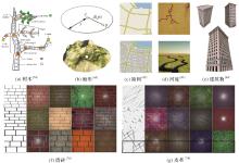
图2
生成式建模方法创建的几何与纹理"


图3
基于还原论的场景构造的基本框架"

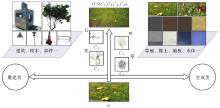
图4
解构的两种维度"
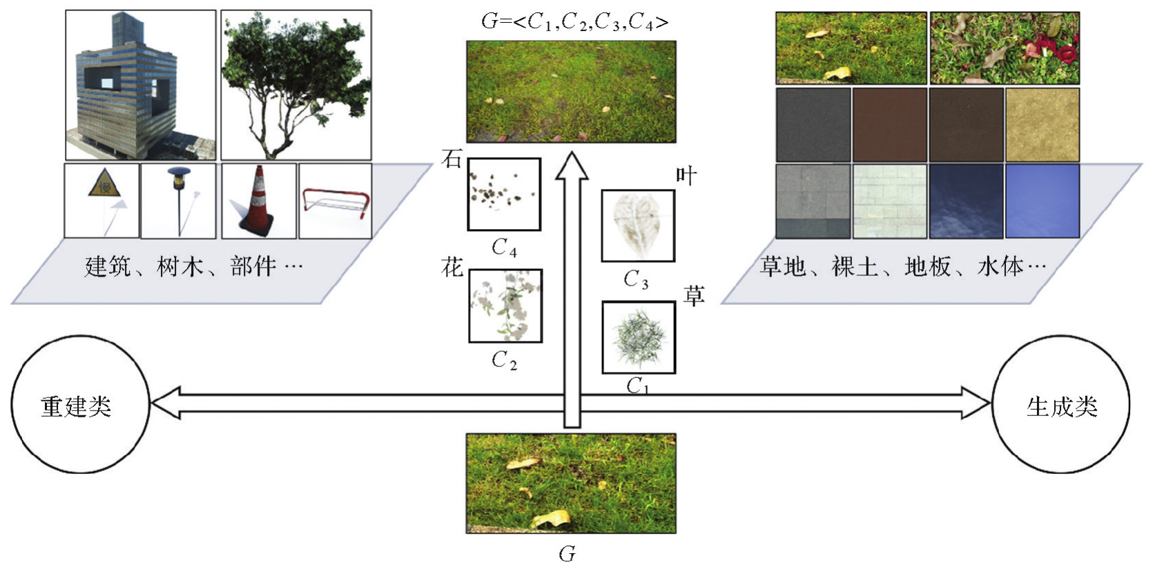
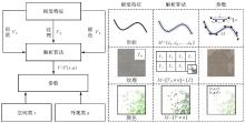
图5
视觉特征的表征和解析"

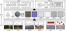
图6
重组的3个模块"

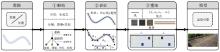
图7
道路模型的构造方法"

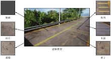
图8
道路段模型的细粒度构成"

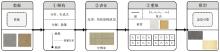
图9
地形表面模型的构造过程"
图10
随机纹理和结构纹理的分布算法"


图11
草地模型的构造过程"

图12
草地中要素模型的属性计算方法"


图13
草体模型的实例化"

图14
建模效果对比"


图15
草地场景的更新"
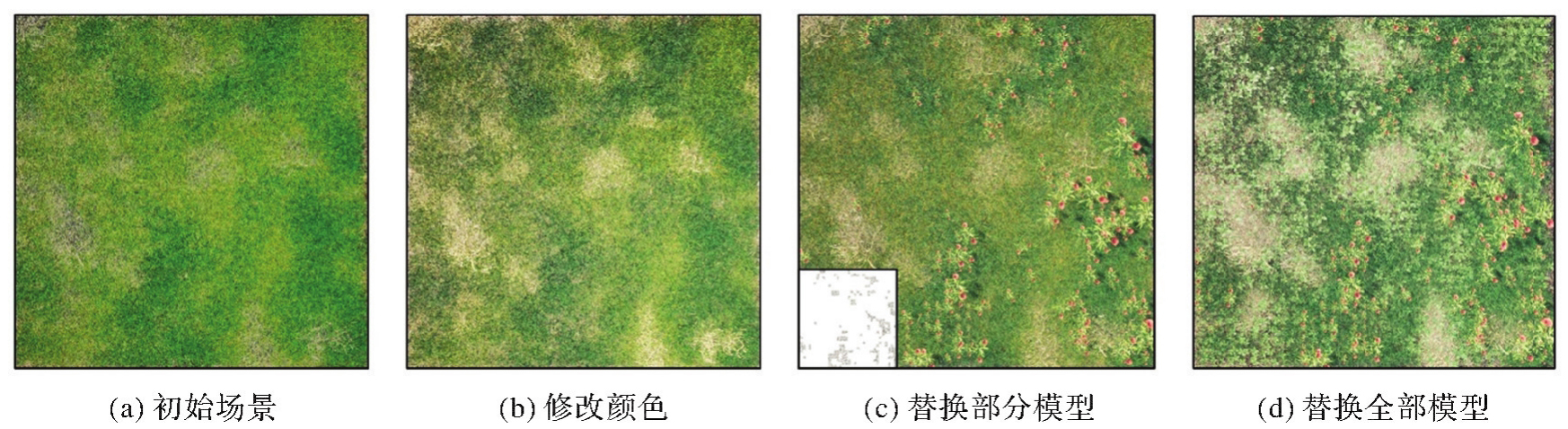
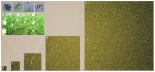
图16
不同范围草地场景的建模效果"

表3
草地场景建模的量化指标"
| ID | 范围 | 初始模型个数 | 初始模型数据量/MB | 参数文件大小/KB | 实例化模型个数 | 三角形个数 | 实例化模型数据量/MB | 生成时间/ms |
|---|---|---|---|---|---|---|---|---|
| 1 | 1×1 | 28 | 610 | 212 572 | 189 | 60 | ||
| 2 | 2×2 | 110 | 2362 | 822 460 | 732 | 92 | ||
| 3 | 4×4 | 4 | 0.31 | 421 | 8990 | 3 109 020 | 2786 | 230 |
| 4 | 8×8 | 1680 | 35 842 | 12 395 202 | 11 111 | 520 | ||
| 5 | 16×16 | 6624 | 141 328 | 48 809 250 | 43 811 | 2620 |
| [1] | GRIEVES M, VICKERS J. Digital twin: mitigating unpredictable, undesirable emergent behavior in complex systems[M]//Transdisciplinary perspectives on complex systems. Cham: Springer International Publishing, 2016: 85-113. |
| [2] | ZHANG Xinchang, LI Shaoying, ZHOU Qiming, et al. Logical and innovative construction of digital twin city[J]. Journal of Geodesy and Geoinformation Science, 2021, 4(4): 113-120. |
| [3] | 陈军, 刘建军, 田海波. 实景三维中国建设的基本定位与技术路径[J]. 武汉大学学报(信息科学版), 2022, 47(10): 1568-1575. |
| CHEN Jun, LIU Jianjun, TIAN Haibo. Basic directions and technological path for building 3D realistic geospatial scene in China[J]. Geomatics and Information Science of Wuhan University, 2022, 47(10): 1568-1575. | |
| [4] |
朱庆, 张利国, 丁雨淋, 等. 从实景三维建模到数字孪生建模[J]. 测绘学报, 2022, 51(6): 1040-1049. DOI: .
doi: 10.11947/j.AGCS.2022.20210640 |
|
ZHU Qing, ZHANG Liguo, DING Yulin, et al. From real 3D modeling to digital twin modeling[J]. Acta Geodaetica et Cartographica Sinica, 2022, 51(6): 1040-1049. DOI: .
doi: 10.11947/j.AGCS.2022.20210640 |
|
| [5] | 自然资源部办公厅. 关于印发《实景三维中国建设技术大纲(2021版)》的通知[EB/OL]. [2024-05-20]. https://m.mnr.gov.cn/gk/tzgg/202108/t20210816_2676831.html. |
| Office of the Ministry of Natural Resources. Notice of the General Office of the Ministry of Natural Resources on Issuing the “Outline of Realistic 3D Construction Technology in China (2021 Edition)”[EB/OL]. [2024-05-20]. https://m.mnr.gov.cn/gk/tzgg/202108/t20210816_2676831.html. | |
| [6] | 刘劲杨. 还原论的两种形相及其思维实质[J]. 自然辩证法通讯, 2007, 29(6): 25-31, 110. |
| LIU Jinyang. Two shapes of reductionism and its essence of thinking[J]. Journal of Dialectics of Nature, 2007, 29(6): 25-31, 110. | |
| [7] | 陶飞, 刘蔚然, 张萌, 等. 数字孪生五维模型及十大领域应用[J]. 计算机集成制造系统, 2019, 25(1): 1-18. |
| TAO Fei, LIU Weiran, ZHANG Meng, et al. Five-dimension digital twin model and its ten applications[J]. Computer Integrated Manufacturing Systems, 2019, 25(1): 1-18. | |
| [8] |
张广运, 张荣庭, 戴琼海, 等. 测绘地理信息与人工智能2.0融合发展的方向[J]. 测绘学报, 2021, 50(8): 1096-1108. DOI: .
doi: 10.11947/j.AGCS.2023.20220262 |
|
ZHANG Guangyun, ZHANG Rongting, DAI Qionghai, et al. The direction of integration surveying and mapping geographic information and artificial intelligence 2.0[J]. Acta Geodaetica et Cartographica Sinica, 2021, 50(8): 1096-1108. DOI: .
doi: 10.11947/j.AGCS.2023.20220262 |
|
| [9] |
张永军, 张祖勋, 龚健雅. 天空地多源遥感数据的广义摄影测量学[J]. 测绘学报, 2021, 50(1): 1-11. DOI: .
doi: 10.11947/j.AGCS.2021.20200245 |
|
ZHANG Yongjun, ZHANG Zuxun, GONG Jianya. Generalized photogrammetry of spaceborne, airborne and terrestrial multi-source remote sensing datasets[J]. Acta Geodaetica et Cartographica Sinica, 2021, 50(1): 1-11. DOI: .
doi: 10.11947/j.AGCS.2021.20200245 |
|
| [10] | 陈宝权, 万国伟. 大规模城市场景建模与理解[J]. 中国计算机学会通讯, 2016, 12(8): 13-19. |
| CHEN Baoquan, WAN Guowei. Modeling and understanding of large scale urban scenarios[J]. Communication from the Chinese Computer Society, 2016, 12(8): 13-19. | |
| [11] | WANG Ruisheng, PEETHAMBARAN J, CHEN Dong. LiDAR point clouds to 3D urban models: a review[J]. IEEE Journal of Selected Topics in Applied Earth Observations and Remote Sensing, 2018, 11(2): 606-627. |
| [12] | GRACIANO A, RUEDA A J, FEITO F R. Real-time visualization of 3D terrains and subsurface geological structures[J]. Advances in Engineering Software, 2018, 115: 314-326. |
| [13] | CHEN Qiyu, LIU Gang, MA Xiaogang, et al. Local curvature entropy-based 3D terrain representation using a comprehensive quadtree[J]. ISPRS Journal of Photogrammetry and Remote Sensing, 2018, 139: 30-45. |
| [14] | 李俊金. 基于Cesium的三维实景可视化技术研究[D]. 郑州: 信息工程大学, 2017. |
| LI Junjin. Research on visualization technology of 3D real scene based on cesium[D]. Zhengzhou: Information Engineering University, 2017. | |
| [15] | VARTHOLOMAIOS A. A machine learning approach to modelling solar irradiation of urban and terrain 3D models[J]. Computers, Environment and Urban Systems, 2019, 78: 101387. |
| [16] | AI Bo, WANG Linyun, YANG Fanlin, et al. Continuous-scale 3D terrain visualization based on a detail-increment model[J]. ISPRS International Journal of Geo-Information, 2019, 8(10): 465. |
| [17] | LARRICK G, TIAN Yun, ROGERS U, et al. Interactive visualization of 3D terrain data stored in the cloud[C]//Proceedings of the 11th IEEE Annual Ubiquitous Computing. New York: IEEE, 2020: 63-70. |
| [18] | DANG Pei, ZHU Jun, WU Jianlin, et al. A real 3D scene rendering optimization method based on region of interest and viewing frustum prediction in virtual reality[J]. International Journal of Digital Earth, 2022, 15(1): 1081-1100. |
| [19] | VAHDATIKHAKI F, EL AMMARI K, LANGROODI A K, et al. Beyond data visualization: a context-realistic construction equipment training simulators[J]. Automation in Construction, 2019, 106: 102853. |
| [20] | WANG Chen, HOU Jingming, MILLER D, et al. Flood risk management in sponge cities: the role of integrated simulation and 3D visualization[J]. International Journal of Disaster Risk Reduction, 2019, 39: 101139. |
| [21] | LEE A, KIM J, JANG I. Movable dynamic data detection and visualization for digital twin city[C]//Proceedings of 2020 IEEE International Conference on Consumer Electronics-Asia. Seoul: IEEE, 2020. |
| [22] | 朱庆, 李函侃, 曾浩炜, 等. 面向数字孪生川藏铁路的实体要素分类与编码研究[J]. 武汉大学学报(信息科学版), 2020, 45(9): 1319-1327. |
| ZHU Qing, LI Hankan, ZENG Haowei, et al. Classification and coding of entity features for digital twin Sichuan-Tibet railway[J]. Geomatics and Information Science of Wuhan University, 2020, 45(9): 1319-1327. | |
| [23] | OEHLKE C, RICHTER R, DÖLLNER J. Automatic detection and large-scale visualization of trees for digital landscapes and city models based on 3D point clouds[C]//Proceedings of the 16th Conference on Digital Landscape Architecture. Dessau: IEEE, 2015: 151-160. |
| [24] | YANG B. GIS based 3D landscape visualization for promoting citizen's awareness of coastal hazard scenarios in flood prone tourism towns[J]. Applied Geography, 2016, 76: 85-97. |
| [25] | EVANGELIDIS K, PAPADOPOULOS T, PAPATHEODOROU K, et al. 3D geospatial visualizations: animation and motion effects on spatial objects[J]. Computers & Geosciences, 2018, 111: 200-212. |
| [26] | 梁慧琳. 苏州环秀山庄园林三维数字化信息研究[D]. 南京: 南京林业大学, 2018. |
| LIANG Huilin. Three-dimensional digital information research for the garden of Huanxiu Shanzhuang, Suzhou, China[D]. Nanjing: Nanjing Forestry University, 2018. | |
| [27] | QIU Yinguo, DUAN Hongtao, XIE Hui, et al. Design and development of a web-based interactive twin platform for watershed management[J]. Transactions in GIS, 2022, 26(3): 1299-1317. |
| [28] | QIU Yinguo, JIAO Yaqin, LUO Juhua, et al. A rapid water region reconstruction scheme in 3D watershed scene generated by UAV oblique photography[J]. Remote Sensing, 2023, 15(5): 1211. |
| [29] | 朱庆, 陈兴旺, 丁雨淋, 等. 视觉感知驱动的三维城市场景数据组织与调度方法[J]. 西南交通大学学报, 2017, 52(5): 869-876. |
| ZHU Qing, CHEN Xingwang, DING Yulin, et al. Organization and scheduling method of 3D urban scene data driven by visual perception[J]. Journal of Southwest Jiaotong University, 2017, 52(5): 869-876. | |
| [30] | YAO Zhihang, NAGEL C, KUNDE F, et al. 3DCityDB - a 3D geodatabase solution for the management, analysis, and visualization of semantic 3D city models based on CityGML[J]. Open Geospatial Data, Software and Standards, 2018, 3(1): 5. |
| [31] | KALFARISI R, WU Zhengyi, SOH K. Crack detection and segmentation using deep learning with 3D reality mesh model for quantitative assessment and integrated visualization[J]. Journal of Computing in Civil Engineering, 2020, 34(3): 04020010. |
| [32] | XU Zhen, WU Yuan, LU Xinzheng, et al. Photo-realistic visualization of seismic dynamic responses of urban building clusters based on oblique aerial photography[J]. Advanced Engineering Informatics, 2020, 43: 101025. |
| [33] |
汪利斌, 胡翰, 朱庆, 等. 局部表面参数化的实景三角网模型语义增强方法[J]. 测绘学报, 2020, 49(2): 225-234. DOI: .
doi: 10.11947/j.AGCS.2020.20180588 |
|
WANG Libin, HU Han, ZHU Qing, et al. A semantic enhancement method for photorealistic mesh model based on local parameterization[J]. Acta Geodaetica et Cartographica Sinica, 2020, 49(2): 225-234. DOI: .
doi: 10.11947/j.AGCS.2020.20180588 |
|
| [34] | ZHI Guozheng, LIAO Zhenliang, TIAN Wenchong, et al. A 3D dynamic visualization method coupled with an urban drainage model[J]. Journal of Hydrology, 2019, 577: 123988. |
| [35] | PEPE M, COSTANTINO D, ALFIO V S, et al. Scan to BIM for the digital management and representation in 3D GIS environment of cultural heritage site[J]. Journal of Cultural Heritage, 2021, 50: |
| [36] | 杜建丽, 陈动, 张振鑫, 等. 建筑点云几何模型重建方法研究进展[J]. 遥感学报, 2019, 23(3): 374-391. |
| DU Jianli, CHEN Dong, ZHANG Zhenxin, et al. Research progress of building reconstruction via airborne point clouds[J]. Journal of Remote Sensing, 2019, 23(3): 374-391. | |
| [37] | 朱庆, 李世明, 胡翰, 等. 面向三维城市建模的多点云数据融合方法综述[J]. 武汉大学学报(信息科学版), 2018, 43(12): 1962-1971. |
| ZHU Qing, LI Shiming, HU Han, et al. Multiple point clouds data fusion method for 3D city modeling[J]. Geomatics and Information Science of Wuhan University, 2018, 43(12): 1962-1971. | |
| [38] | AMENTA N, BERN M, KAMVYSSELIS M. A new Voronoi-based surface reconstruction algorithm[C]//Proceedings of the 25th Annual Conference on Computer Graphics and Interactive Techniques. New York: ACM Press, 1998: 415-421. |
| [39] | KAZHDAN M, BOLITHO M, HOPPE H. Poisson surface reconstruction[C]//Proceedings of the 4th Eurographics Symposium on Geometry Processing. Goslar: IEEE, 2006: 61-70. |
| [40] | KAZHDAN M, HOPPE H. Screened Poisson surface reconstruction[J]. ACM Transactions on Graphics, 2013, 32(3): 1-13. |
| [41] | SELLÁN S, JACOBSON A. Stochastic Poisson surface reconstruction[J]. ACM Transactions on Graphics, 2022, 41(6): 1-12. |
| [42] |
单杰, 李志鑫, 张文元. 大规模三维城市建模进展[J]. 测绘学报, 2019, 48(12): 1523-1541. DOI: .
doi: 10.11947/j.AGCS.2019.20190471 |
|
SHAN Jie, LI Zhixin, ZHANG Wenyuan. Recent progress in large-scale 3D city modeling[J]. Acta Geodaetica et Cartographica Sinica, 2019, 48(12): 1523-1541. DOI: .
doi: 10.11947/j.AGCS.2019.20190471 |
|
| [43] | GONG Jianya, JI Shunping. Photogrammetry and deep learning[J]. Journal of Geodesy and Geoinformation Science, 2018, 1(1): 1-15. |
| [44] | YANG B, LEE J. Improving accuracy of automated 3D building models for smart cities[J]. International Journal of Digital Earth, 2019, 12(2): 209-227. |
| [45] |
张春森, 张卫龙, 郭丙轩, 等. 倾斜影像的三维纹理快速重建[J]. 测绘学报, 2015, 44(7): 782-790. DOI: .
doi: 10.11947/j.AGCS.2015.20140544 |
|
ZHANG Chunsen, ZHANG Weilong, GUO Bingxuan, et al. Rapidly 3D texture reconstruction based on oblique photography[J]. Acta Geodaetica et Cartographica Sinica, 2015, 44(7): 782-790. DOI: .
doi: 10.11947/j.AGCS.2015.20140544 |
|
| [46] | LEE J, YANG B. Developing an optimized texture mapping for photorealistic 3D buildings[J]. Transactions in GIS, 2019, 23(1): 1-21. |
| [47] | MANDELBROT B B. The fractal geometry of nature[M]. New York: W. H. Freeman and Company, 1982. |
| [48] | PRUSINKIEWICZ P, LINDENMAYER A. The algorithmic beauty of plants[M]. [S.l.]: Springer Science & Business Media, 2012. |
| [49] | PERLIN K. An image synthesizer[J]. ACM SIGGRAPH Computer Graphics, 1985, 19(3): 287-296. |
| [50] | PERLIN K. Improving noise[C]//Proceedings of the 29th Annual Conference on Computer Graphics and Interactive Techniques. San Antonio Texas: ACM Press, 2002: 681-682. |
| [51] | PARISH Y I H, MÜLLER P. Procedural modeling of cities[C]//Proceedings of the 28th Annual Conference on Computer Graphics and Interactive Techniques. California: ACM Press, 2001: 301-308. |
| [52] | TALLE J, KOSINKA J. Evolving L-systems in a competitive environment[M]//Advances in computer graphics. Cham: Springer International Publishing, 2020: 326-350. |
| [53] | IJIRI T, OWADA S, IGARASHI T. The sketch L-system: global control of tree modeling using free-form strokes[M]//Smart graphics. Berlin: Springer, 2006: 138-146. |
| [54] | HOETZLEIN R. A procedural model for diverse tree species[C]//Proceedings of the 17th International Conference on the Foundations of Digital Games. Athens Greece: ACM Press, 2022: 1-8. |
| [55] | NIESE T, PIRK S, ALBRECHT M, et al. Procedural urban forestry[J]. ACM Transactions on Graphics, 2022, 41(2): 1-18. |
| [56] | SMELIK R M, DE KRAKER K J, TUTENEL T, et al. A survey of procedural methods for terrain modelling[C]//Proceedings of 2009 CASA Workshop on 3D Advanced Media in Gaming and Simulation, Amsterdam: IEEE, 2009: 25-34. |
| [57] | FOURNIER A, FUSSELL D, CARPENTER L. Computer rendering of stochastic models[J]. Communications of the ACM, 1982, 25(6): 371-384. |
| [58] | MUSGRAVE F K. Methods for realistic landscape imaging[M]. Yale: Yale University, 1993. |
| [59] | SANTAMARÍA-IBIRIKA A, CANTERO X, SALAZAR M, et al. Procedural approach to volumetric terrain generation[J]. The Visual Computer, 2014, 30(9): 997-1007. |
| [60] | GÉNEVAUX J D, GALIN E, PEYTAVIE A, et al. Terrain modelling from feature primitives[J]. Computer Graphics Forum, 2015, 34(6): 198-210. |
| [61] | HNAIDI H, GUÉRIN E, AKKOUCHE S, et al. Feature based terrain generation using diffusion equation[J]. Computer Graphics Forum, 2010, 29(7): 2179-2186. |
| [62] | TENG E, BIDARRA R. A semantic approach to patch-based procedural generation of urban road networks[C]//Proceedings of the 12th International Conference on the Foundations of Digital Games. Hyannis Massachusetts: ACM Press, 2017: 1-10. |
| [63] | ZHANG Jian, WANG Changbo, QIN Hong, et al. Procedural modeling of rivers from single image toward natural scene production[J]. The Visual Computer, 2019, 35(2): 223-237. |
| [64] | NISHIDA G, BOUSSEAU A, ALIAGA D G. Procedural modeling of a building from a single image[J]. Computer Graphics Forum, 2018, 37(2): 415-429. |
| [65] | HOU Fei, QIN Hong, QI Yue. Procedure-based component and architecture modeling from a single image[J]. The Visual Computer, 2016, 32(2): 151-166. |
| [66] | RAISTRICK A, LIPSON L, MA Z, et al. Infinite photorealistic worlds using procedural generation[C]//Proceedings of 2023 IEEE/CVF Conference on Computer Vision and Pattern Recognition. Vancouver: IEEE, 2023: 12630-12641. |
| [67] | YOKOYAMA R, HARALICK R M. Texture synthesis using a growth model[J]. Computer Graphics and Image Processing, 1978, 8(3): 369-381. |
| [68] | GAGALOWICZ A, MASONG DE S. Sequential synthesis of natural textures[J]. Computer Vision, Graphics, and Image Processing, 1985, 30(3): 289-315. |
| [69] | GUEHL P, ALLÈGRE R, DISCHLER J M, et al. Semi-procedural textures using point process texture basis functions[J]. Computer Graphics Forum, 2020, 39(4): 159-171. |
| [70] | LAGAE A, VANGORP P, LENAERTS T, et al. Procedural isotropic stochastic textures by example[J]. Computers & Graphics, 2010, 34(4): 312-321. |
| [71] | GILET G, SAUVAGE B, VANHOEY K, et al. Local random-phase noise for procedural texturing[J]. ACM Transactions on Graphics, 2014, 33(6): 1-11. |
| [72] | TURK G. Generating textures on arbitrary surfaces using reaction-diffusion[J]. ACM Siggraph Computer Graphics, 1991, 25(4): 289-298. |
| [73] | WORLEY S. A cellular texture basis function[C]//Proceedings of the 23rd Annual Conference on Computer Graphics and Interactive Techniques. New Orleans: ACM Press, 1996: 291-294. |
| [74] | HO Y X, LANDY M S, MALONEY L T. Conjoint measurement of gloss and surface texture[J]. Psychological Science, 2008, 19(2): 196-204. |
| [75] | DONG Junyu, LIU Jun, YAO Kang, et al. Survey of procedural methods for two-dimensional texture generation[J]. Sensors, 2020, 20(4): 1135. |
| [76] | ZHOU Xilong, HASAN M, DESCHAINTRE V, et al. TileGen: tileable, controllable material generation and capture[C]//Proceedings of 2022 Conference Papers. New York: ACM Press, 2022: 1-9. |
| [77] | SPICK R R, WALKER J. Realistic and textured terrain generation using GANs[C]//Proceedings of 2019 European Conference on Visual Media Production. London: ACM Press, 2019: 1-10. |
| [78] | TALTON J O, LOU Yu, LESSER S, et al. Metropolis procedural modeling[J]. ACM Transactions on Graphics, 2011, 30(2): 1-14. |
| [79] | RITCHIE D, MILDENHALL B, GOODMAN N D, et al. Controlling procedural modeling programs with stochastically-ordered sequential Monte Carlo[J]. ACM Transactions on Graphics, 2015, 34(4): 1-11. |
| [80] | DE CARPENTIER G J P, BIDARRA R. Interactive GPU-based procedural heightfield brushes[C]//Proceedings of the 4th International Conference on Foundations of Digital Games. New York: ACM Press, 2009: 55-62. |
| [81] | KOHEK Š, STRNAD D. Interactive large-scale procedural forest construction and visualization based on particle flow simulation[J]. Computer Graphics Forum, 2018, 37(1): 389-402. |
| [82] | SMELIK R M, TUTENEL T, BIDARRA R, et al. A survey on procedural modelling for virtual worlds[J]. Computer Graphics Forum, 2014, 33(6): 31-50. |
| [83] | TREISMAN A M, GELADE G. A feature-integration theory of attention[J]. Cognitive Psychology, 1980, 12(1): 97-136. |
| [84] | Khronos 3D Formats Working Group. GLTF 2.0 Specification[EB/OL]. [2024-06-8]. https://github.com/KhronosGroup/glTF. |
| [85] | FERNANDO R. GPU精粹—实时图形编程的技术、技巧和技艺[M]. 姚勇, 王小琴,译. 北京: 人民邮电出版社. 2006. |
| FERNANDO R. GPU gems: programming techniques, tips and tricks for real-time graphics[M]. YAO Yong, WANG Xiaoqin, Trans. Beijing: Pearson Higher Education, 2004. | |
| [86] | 朱庆. 三维GIS及其在智慧城市中的应用[J]. 地球信息科学学报, 2014, 16(2): 151-157. |
| ZHU Qing. Full three-dimensional GIS and its key roles in smart city[J]. Journal of Geo-information Science, 2014, 16(2): 151-157. | |
| [87] | 高俊. 地理空间数据的可视化[J]. 测绘工程, 2000, 9(3): 1-7. |
| GAO Jun. Visualization in geo-spatial data[J]. Engineering of Surveying and Mapping, 2000, 9(3): 1-7. | |
| [88] |
郭仁忠, 陈业滨, 马丁, 等. 论ICT时代的泛地图表达[J]. 测绘学报, 2022, 51(7): 1108-1113. DOI: .
doi: 10.11947/j.AGCS.2022.20220140 |
|
GUO Renzhong, CHEN Yebin, MA Ding, et al. Pan-map representation in ICT era[J]. Acta Geodaetica et Cartographica Sinica, 2022, 51(7): 1108-1113. DOI: .
doi: 10.11947/j.AGCS.2022.20220140 |
| [1] | 郭仁忠, 贺彪, 赵志刚, 李晓明, 蒯希, 林浩嘉, 陈业滨, 马丁. 智慧城市逻辑架构与孪生平台技术需求[J]. 测绘学报, 2025, 54(5): 777-784. |
| [2] | 杨元喜. 地理空间数字孪生与时空智能[J]. 测绘学报, 2025, 54(2): 213-220. |
| [3] | 吴浩宇, 朱庆, 丁雨淋, 鲍榴, 刘利. 数据模型知识协同驱动的隧道围岩高精度数字孪生建模方法[J]. 测绘学报, 2025, 54(10): 1893-1906. |
| [4] | 朱庆, 张利国, 丁雨淋, 胡翰, 葛旭明, 刘铭崴, 王玮. 从实景三维建模到数字孪生建模[J]. 测绘学报, 2022, 51(6): 1040-1049. |
| [5] | 郑束蕾. 地理空间认知理论与地图工具的发展[J]. 测绘学报, 2021, 50(6): 766-776. |
| 阅读次数 | ||||||
|
全文 |
|
|||||
|
摘要 |
|
|||||