


测绘学报 ›› 2025, Vol. 54 ›› Issue (9): 1583-1595.doi: 10.11947/j.AGCS.2025.20240520
押少帅1( ), 刘新1(), 周瑞宸2,3, 李真1, 边少锋4, 郭金运1
收稿日期:2025-01-06
修回日期:2025-08-15
出版日期:2025-10-10
发布日期:2025-10-10
通讯作者:
刘新
E-mail:13526663057@163.com;xinliu1969@126.com
作者简介:押少帅(1992—),男,博士,研究方向为卫星测高数据处理及海洋重力梯度反演。E-mail:13526663057@163.com
基金资助:
Shaoshuai YA1(), Xin LIU1(), Ruichen ZHOU2,3, Zhen LI1, Shaofeng BIAN4, Jinyun GUO1
Received:2025-01-06
Revised:2025-08-15
Online:2025-10-10
Published:2025-10-10
Contact:
Xin LIU
E-mail:13526663057@163.com;xinliu1969@126.com
About author:YA Shaoshuai (1992—), male, PhD, majors in altimeter data processing and marine gravity anomalies recovery. E-mail: 13526663057@163.com
Supported by:摘要:
卫星测高技术是反演海洋垂直重力异常梯度的重要手段之一。针对常规的一维测高数据采样间隔大、跨轨数据稀疏、精度低的问题,SWOT(surface water and ocean topography)测高卫星可以提供二维宽刈幅海洋信息,获取更高空间分辨率和精度的海面高。本文基于1~20周期的SWOT海面高数据反演垂直重力异常梯度模型(SWOT_VGGA),首先,采用移去-恢复法的处理策略,将XGM2019e_2159作为参考场模型;然后,联合沿轨、跨轨和对角线3个方向的测高数据,并利用最小二乘配置法解算垂线偏差;最后,根据垂线偏差和参考场反演出SWOT_VGGA模型。本文选择菲律宾海为试验区域,将SIO V32.1版本的垂直重力异常梯度(SIO_curv_32.1)作为参考模型,结果表明SWOT_VGGA与SIO_curv_32.1模型的一致性为8.25 E,验证了一年SWOT测高数据反演垂直重力异常梯度的可靠性。此外,对SWOT_VGGA模型在不同水深、离岸距离和海底坡角的一致性进行了统计分析。结果表明,多周期SWOT_VGGA模型的一致性要优于单周期,而且1~10和11~20周期的SWOT_VGGA模型之间的一致性为1.81 E。因此,SWOT卫星在不同周期的数据质量比较稳定,可以用来反演高精度的海洋重力信息。
中图分类号:
押少帅, 刘新, 周瑞宸, 李真, 边少锋, 郭金运. 基于科学阶段SWOT/KaRIn测高数据反演高精度的垂直重力异常梯度模型[J]. 测绘学报, 2025, 54(9): 1583-1595.
Shaoshuai YA, Xin LIU, Ruichen ZHOU, Zhen LI, Shaofeng BIAN, Jinyun GUO. High accuracy vertical gradient of gravity anomaly model determined from SWOT/KaRIn altimetry data during scientific phase[J]. Acta Geodaetica et Cartographica Sinica, 2025, 54(9): 1583-1595.

图1
菲律宾海域海深"


图2
SWOT在菲律宾海的海面高"


图3
沿轨、跨轨和对角线方向的大地水准面梯度"
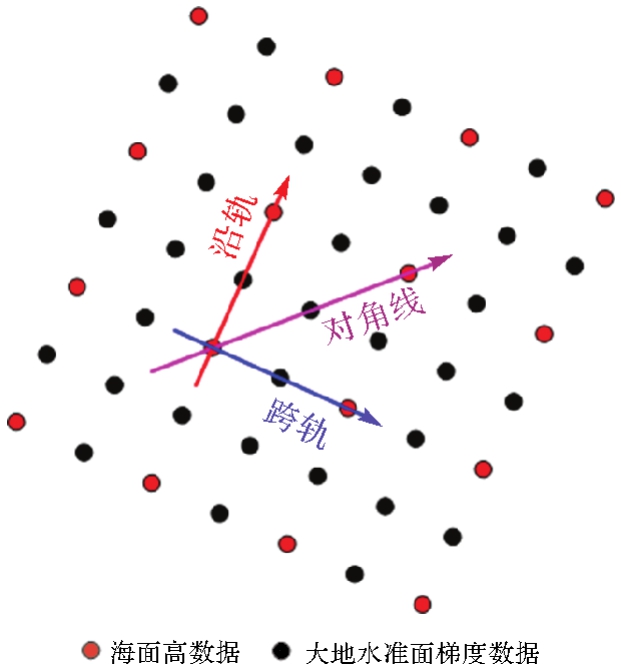

图4
垂直重力异常梯度模型的流程"

表1
SWOT海面高交叉点不符值的统计结果"
| 周期 | 数量 | 最大值 | 最小值 | 均值 | 标准差 | 均方根 |
|---|---|---|---|---|---|---|
| 1~20 | 1 442 392 | 0.061 | -0.061 | 0.000 | 0.016 | 0.016 |
| 5 | 1 278 929 | 0.203 | -0.203 | 0.002 | 0.059 | 0.059 |
| 10 | 1 332 836 | 0.183 | -0.183 | 0.003 | 0.053 | 0.053 |
| 13 | 1 303 739 | 0.202 | -0.202 | -0.001 | 0.059 | 0.059 |
| 20 | 1 234 200 | 0.194 | -0.194 | 0.000 | 0.058 | 0.058 |

图5
SWOT数据反演的SWOT_DOV模型"

表2
SWOT_DOV模型与SIO_DOV_32.1模型的差值统计结果"
| 不同分量 | 最大值 | 最小值 | 均值 | 标准差 | 均方根 |
|---|---|---|---|---|---|
| 北分量 | 80.86 | -62.76 | 0.02 | 1.93 | 1.93 |
| 东分量 | 132.62 | -67.95 | 0.05 | 2.53 | 2.53 |

图6
SWOT数据反演的SWOT_VGGA模型"

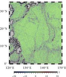
图7
SWOT_VGGA模型与SIO_curv_32.1模型的差值"

表3
SWOT_VGGA模型与SIO_curv_32.1模型的差值统计结果"
| 最大值 | 最小值 | 均值 | 标准差 | 均方根 |
|---|---|---|---|---|
| 358.06 | -391.04 | 0.07 | 8.25 | 8.25 |

图8
SWOT_VGGA模型与SIO_curv_32.1模型的差值分布"
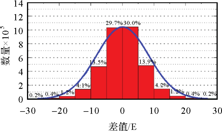

图9
SWOT_VGGA模型与SIO_curv_32.1模型的功率谱密度"

表4
SWOT_VGGA模型与SIO_curv_32.1模型在不同水深下的差值统计结果"
| 不同水深/m | 最大值/E | 最小值/E | 均值/E | 标准差/E | 均方根/E |
|---|---|---|---|---|---|
| (0,1000] | 358.06 | -373.53 | -0.24 | 16.22 | 16.22 |
| (1000,2000] | 193.31 | -391.04 | 0.30 | 12.94 | 12.95 |
| (2000,3000] | 144.86 | -75.15 | -0.13 | 9.05 | 9.05 |
| (3000,4000] | 80.89 | -56.94 | 0.04 | 7.26 | 7.26 |
| (4000,5000] | 70.61 | -41.99 | 0.08 | 5.90 | 5.90 |
| (5000,∞) | 42.52 | -43.61 | 0.19 | 4.92 | 4.93 |
表5
SWOT_VGGA模型与SIO_curv_32.1模型在不同离岸距离下的差值统计结果"
| 离岸距离/km | 最大值/E | 最小值/E | 均值/E | 标准差/E | 均方根/E |
|---|---|---|---|---|---|
| (0,50] | 358.06 | -391.04 | 0.44 | 18.93 | 18.93 |
| (50,100] | 154.91 | -228.64 | 0.03 | 8.19 | 8.19 |
| (100,150] | 65.81 | -79.51 | 0.05 | 6.94 | 6.95 |
| (150,200] | 62.85 | -55.56 | 0.05 | 6.48 | 6.48 |
| (200,250] | 56.06 | -44.07 | 0.03 | 6.22 | 6.22 |
| (250,300] | 43.61 | -71.04 | 0.02 | 6.16 | 6.16 |
| (300,∞) | 94.65 | -76.67 | 0.02 | 5.74 | 5.74 |
表6
SWOT_VGGA模型与SIO_curv_32.1模型在不同海底坡角下的差值统计结果"
| 坡角/(°) | 最大值/E | 最小值/E | 均值/E | 标准差/E | 均方根/E |
|---|---|---|---|---|---|
| [0,2] | 358.06 | -274.77 | 0.15 | 7.00 | 7.00 |
| (2,4] | 273.40 | -228.53 | 0.05 | 8.00 | 8.00 |
| (4,6] | 278.89 | -316.45 | -0.03 | 9.11 | 9.11 |
| (6,8] | 222.55 | -253.63 | -0.10 | 9.77 | 9.77 |
| (8,10] | 220.55 | -248.45 | -0.01 | 10.55 | 10.55 |
| (10,∞) | 211.07 | -391.04 | -0.10 | 11.97 | 11.97 |

图10
菲律宾海域3个研究区域的位置"

表7
3个研究区域的差值统计结果"
| 不同区域 | 最大值 | 最小值 | 均值 | 标准差 | 均方根 |
|---|---|---|---|---|---|
| 区域1 | 20.10 | -20.74 | 0.04 | 4.77 | 4.77 |
| 区域2 | 48.76 | -95.41 | -0.05 | 6.82 | 6.82 |
| 区域3 | 122.25 | -124.55 | 0.13 | 8.64 | 8.64 |
表8
不同窗口长度反演的SWOT_VGGA模型与SIO_curv_32.1模型的差值统计结果"
| 窗口长度/(°) | 最大值/E | 最小值/E | 均值/E | 标准差/E | 均方根/E |
|---|---|---|---|---|---|
| 0.1 | 29.59 | -26.56 | 0.02 | 5.08 | 5.08 |
| 0.2 | 29.19 | -27.45 | 0.02 | 4.95 | 4.95 |
| 0.3 | 29.39 | -30.14 | 0.02 | 4.98 | 4.98 |
| 0.4 | 29.28 | -29.56 | 0.02 | 4.98 | 4.98 |
表9
EGM2008参考场反演的SWOT_VGGA模型与SIO_curv_32.1模型的差值统计结果"
| 参考场 | 最大值 | 最小值 | 均值 | 标准差 | 均方根 |
|---|---|---|---|---|---|
| EGM2008 | 313.67 | -413.11 | 0.12 | 9.78 | 9.79 |
表10
不同周期的SWOT_VGGA模型与SIO_curv_32.1模型的差值统计结果"
| 不同周期 | 最大值 | 最小值 | 均值 | 标准差 | 均方根 |
|---|---|---|---|---|---|
| 1~10 | 357.84 | -393.59 | 0.07 | 8.26 | 8.26 |
| 11~20 | 358.31 | -392.88 | 0.07 | 8.27 | 8.27 |
| 4 | 357.19 | -391.27 | 0.08 | 8.43 | 8.43 |
| 15 | 357.88 | -398.70 | 0.04 | 9.71 | 9.71 |
表11
1~10和11~20周期SWOT_VGGA模型的差值统计结果"
| 最大值 | 最小值 | 均值 | 标准差 | 均方根 |
|---|---|---|---|---|
| 73.35 | -59.61 | 0 | 1.81 | 1.81 |
表12
不同VGGA模型之间的差值统计结果"
| 不同模型 | 最大值 | 最小值 | 均值 | 标准差 | 均方根 |
|---|---|---|---|---|---|
| SWOT_VGGA与curv_SWOT_02 | 247.74 | -253.08 | 0.07 | 7.83 | 7.83 |
| SIO_curv_32.1与curv_SWOT_02 | 249.46 | -169.95 | 0.06 | 6.54 | 6.54 |
| [1] | ODALOVIC O, MEDVED K, NAOD S. Modeling of vertical gravity gradient by normal gravity field and digital terrain models[J]. Journal of Geodesy, 2022, 96(10): 74. |
| [2] |
胡敏章, 李建成, 邢乐林et al.. 由垂直重力梯度异常反演全球海底地形模型[J]. 测绘学报, 2014, 43(6): 558-565, 574. DOI: .
doi: 10.13485/j.cnki.11-2089.2014.0090 |
|
HU Minzhang, LI Jiancheng, XING Lelinet al.. Global bathymetry model predicted from vertical gravity gradient anomalies[J]. Acta Geodaetica et Cartographical Sinica, 2014, 43(6): 558-565, 574. DOI: .
doi: 10.13485/j.cnki.11-2089.2014.0090 |
|
| [3] | ZHENG Wei, HSU H T, ZHONG Min, et al. A contrastive study on the influences of radial and three-dimensional satellite gravity gradiometry on the accuracy of the Earth's gravitational field recovery[J]. Chinese Physics B, 2012, 21(10): 109101. |
| [4] | WAN Xiaoyun, RAN Jiangjun. An alternative method to improve gravity field models by incorporating GOCE gradient data[J]. Earth Sciences Research Journal, 2018, 22(3): 187-193. |
| [5] | 郭金运, 吴渴知, 金鑫, 等. 高精度三维跟踪抛物运动的重力垂直梯度测量方法[J]. 武汉大学学报(信息科学版), 2025, 50(3): 462-468. |
| GUO Jinyun, WU Kezhi, JIN Xin, et al. A method to determine vertical gravity gradient by high-precision 3D tracking parabolic motion[J]. Geomatics and Information Science of Wuhan University, 2025, 50(3): 462-468. | |
| [6] | 赵永奇, 李建成, 徐新禹, 等. 利用GOCE和GRACE卫星观测数据确定静态重力场模型[J]. 地球物理学报, 2023, 66(6): 2322-2336. |
| ZHAO Yongqi, LI Jiancheng, XU Xinyu, et al. Determination of static gravity field model by using satellite data of GOCE and GRACE[J]. Chinese Journal of Geophysics, 2023, 66(6): 2322-2336. | |
| [7] | STRAY B, LAMB A, KAUSHIK A, et al. Quantum sensing for gravity cartography[J]. Nature, 2022, 602(7898): 590-594. |
| [8] |
黄佳喜, 边少锋, 纪兵et al.. 航空重力梯度地形改正[J]. 测绘学报, 2024, 53(8): 1540-1551. DOI: .
doi: 10.11947/j.AGCS.2024.20230342 |
|
HUANG Jiaxi, BIAN Shaofeng, JI Binget al.. Terrain corrections for airborne gravity gradiometry[J]. Acta Geodaetica et Cartographica Sinica, 2024, 53(8): 1540-1551. DOI: .
doi: 10.11947/j.AGCS.2024.20230342 |
|
| [9] | HSIAO Y S, HWANG C, WU Mengling, et al. Improved geoid modeling using observed and modeled gravity gradients in Taiwan[J]. Journal of Surveying Engineering, 2017, 143(2): 04016027. |
| [10] | ZHOU Ruichen, LIU Xin, LI Zhen, et al. On performance of vertical gravity gradient determined from CryoSat-2 altimeter data over Arabian SeaFree[J]. Geophysical Journal International, 2023, 234(2): 1519-1529. |
| [11] | 吴怿昊, 何秀凤, 罗志才, 等. 基于航空重力梯度数据重建高分辨率局部重力场的径向基函数方法[J]. 地球物理学报, 2024, 67(5): 1913-1926. |
| WU Yihao, HE Xiufeng, LUO Zhicai, et al. The approach for high-resolution local gravity field recovery from airborne gravity gradient data based on radial basis functions[J]. Chinese Journal of Geophysics, 2024, 67(5): 1913-1926. | |
| [12] | EVSTIFEEV M I. The state of the art in the development of onboard gravity gradiometers[J]. Gyroscopy and Navigation, 2017, 8(1): 68-79. |
| [13] | DRANSFIELD M H, CHRISTENSEN A N. Performance of airborne gravity gradiometers[J]. The Leading Edge, 2013, 32(8): 908-922. |
| [14] | LEE J. Falcon gravity gradiometer technology[J]. Exploration Geophysics, 2001, 32(3-4): 247-250. |
| [15] | HINKS D, MCINTOSH S, LANE R. A comparison of the Falcon and Air-FTG airborne gravity gradiometer systems at the Kokong Test Block, Botswana[C]//Proceedings of 2004 Airborne Gravity. Sydney: Geoscience Australia Record, 2004: 125-134. |
| [16] | 钟波, 刘滔, 李贤炮, 等. 卫星重力梯度精化局部重力场的径向基函数法[J]. 华中科技大学学报(自然科学版), 2022, 50(9): 141-148. |
| ZHONG Bo, LIU Tao, LI Xianpao, et al. Radial basis function method for refining regional gravity field from satellite gravity gradient[J]. Journal of Huazhong University of Science and Technology (Natural Science Edition), 2022, 50(9): 141-148. | |
| [17] | 郭金运, 张鸿飞, 李真, 等. 多源船载重力异常数据的联合再处理:以墨西哥湾为例[J]. 武汉大学学报(信息科学版), 2025, 50(7): 1277-1290. |
| GUO Jinyun, ZHANG Hongfei, LI Zhen, et al. Joint reprocessing of multi-sources shipborne gravity anomalies: a case study of gulf of Mexico[J]. Geomatics and Information Science of Wuhan University, 2025, 50(7): 1277-1290. | |
| [18] |
李真, 郭金运, 孙中苗, 等. 基于ICESat-2多波束激光测高数据的全球海洋重力异常反演分析[J]. 测绘学报, 2024, 53(2): 252-262. DOI: .
doi: 10.11947/j.AGCS.2024.20230207 |
|
LI Zhen, GUO Jinyun, SUN Zhongmiao, et al. Global marine gravity anomalies recovered from multi-beam laser altimeter data of ICESat-2[J]. Acta Geodaetica et Cartographical Sinica. 2024, 53(2): 252-262. DOI: .
doi: 10.11947/j.AGCS.2024.20230207 |
|
| [19] | LIU Xin, SONG Menghao, LI Chao, et al. Inversion method of deflection of the vertical based on SWOT wide-swath altimeter data[J]. Geodesy and Geodynamics, 2024, 15(4): 419-428. |
| [20] | 王虎彪, 王勇, 陆洋, 等. 联合多种测高资料确定西太平洋海域2′×2′重力梯度[J]. 地球物理学进展, 2009, 24(3): 852-858. |
| WANG Hubiao, WANG Yong, LU Yang, et al. Determination of gravity gradients in the Western Pacific Ocean by combinating multi-altimeter data[J]. Progress in Geophysics, 2009, 24(3): 852-858. | |
| [21] | BAO Lifeng, XU Houze, LI Zhicai. Towards a 1 mGal accuracy and 1 Min resolution altimetry gravity field[J]. Journal of Geodesy, 2013, 87(10): 961-969. |
| [22] | BOUMAN J, BOSCH W, SEBERA J. Assessment of systematic errors in the computation of gravity gradients from satellite altimeter data[J]. Marine Geodesy, 2011, 34(2): 85-107. |
| [23] | ANNAN R F, WAN Xiaoyun, HAO Ruijie, et al. Global marine gravity gradient tensor inverted from altimetry-derived deflections of the vertical: CUGB2023GRAD[J]. Earth System Science Data, 2024, 16(3): 1167-1176. |
| [24] | ZHOU Shuai, LIU Xin, GUO Jinyun, et al. Bathymetry of the gulf of Mexico predicted with multilayer perceptron from multisource marine geodetic data[J]. IEEE Transactions on Geoscience and Remote Sensing, 2023, 61: 1-11. |
| [25] | AKDOĞAN Y, YILDIZ H, AHI G, et al. Evaluation of global gravity models from absolute gravity and vertical gravity gradient measurements in Turkey[J]. Measurement Science and Technology. 2019, 30(11): 115009. |
| [26] | WU Lin, WANG Hubiao, CHAI Hua, et al. Research on the relative positions-constrained pattern matching method for underwater gravity-aided inertial navigation[J]. Journal of Navigation, 2015, 68(5): 937-950. |
| [27] | ORUÇ B. Edge detection and depth estimation using a tilt angle map from gravity gradient data of the Kozaklı-Central Anatolia region, Turkey[J]. Pure and Applied Geophysics, 2011, 168(10): 1769-1780. |
| [28] | FU L L, PAVELSKY T, CRETAUX J F, et al. The surface water and ocean topography mission: a breakthrough in radar remote sensing of the ocean and land surface water[J]. Geophysical Research Letters, 2024, 51(4): e2023GL107652. |
| [29] | YU Y, SANDWELL D T, DIBARBOURE G, et al. Accuracy and resolution of SWOT altimetry: foundation seamounts[J]. Earth and Space Science, 2024, 11(6): e2024EA003581. |
| [30] | YU Daocheng, WENG Zequn, HWANG C, et al. Seamount detection using SWOT-derived vertical gravity gradient: advancements and challenges open access[J]. Geophysical Journal International, 2024, 237(3): 1780-1793. |
| [31] | JIN Taoyong, ZHOU Mao, ZHANG Huan, et al. Analysis of vertical deflections determined from one cycle of simulated SWOT wide-swath altimeter data[J]. Journal of Geodesy, 2022, 96(4): 30. |
| [32] | CASULLA M A A, MIZUNAGA H, TANAKA T, et al. Imaging crustal features and Moho depths through enhancements and inversion of gravity data from the Philippine island arc system[J]. Progress in Earth and Planetary Science, 2022, 9(1): 16. |
| [33] | ZHU C, GUO J, YA S, et al. Moving geoid gradient method for high-precision and high-resolution gravity recovery from SWOT wide-Swath data[J]. IEEE Transactions on Geoscience and Remote Sensing. 2025, 63: 4205613. |
| [34] | SCHAEFFER P, PUJOL M I, VEILLARD P, et al. The CNES CLS 2022 mean sea surface: short wavelength improvements from CryoSat-2 and SARAL/AltiKa high-sampled altimeter data[J]. Remote Sensing, 2023, 15(11): 2910. |
| [35] | JOUSSET S, MULET S, WILKIN J, et al. New global mean dynamic topography CNES-CLS-22 combining drifters, hydrological profiles and High Frequency radar data[C]//Proceedings of 2022 Ocean Surface Topography Science Team Meeting. Venice: IEEE, 2022. |
| [36] | ZINGERLE P, PAIL R, SCHEINERT M, et al. Evaluation of terrestrial and airborne gravity data over Antarctica-a generic approach[J]. Journal of Geodetic Science, 2019, 9(1): 29-40. |
| [37] | ZINGERLE P, PAIL R, GRUBER T, et al. The combined global gravity field model XGM2019e[J]. Journal of Geodesy, 2020, 94(7): 66-72. |
| [38] | ZAKI A, ABDALLAH M, EL-ASHQUER M, et al. Marine gravity modelling from SARAL/AltiKA data using the least square collocation for the Red Sea[J]. The Egyptian Journal of Remote Sensing and Space Sciences, 2023, 26(3): 607-617. |
| [39] | ANDERSEN O B, ZHANG Shengjun, SANDWELL D T, et al. The unique role of the Jason geodetic missions for high resolution gravity field and mean sea surface modelling[J]. Remote Sensing, 2021, 13(4): 646-651. |
| [40] | ZHU Chengcheng, GUO Jinyun, GAO Jinyao, et al. Marine gravity determined from multi-satellite GM/ERM altimeter data over the South China Sea: SCSGA V1.0[J]. Journal of Geodesy, 2020, 94(5): 50-55. |
| [41] | TSCHERNING C, RAPP R. Closed covariance expressions for gravity anomalies, geoid undulations, and deflections of the vertical implied by anomaly degree variance models[R]. Ohio State University: Division of Geodetic Science, 1974. |
| [42] | HWANG C, PARSONS B. Gravity anomalies derived from Seasat, Geosat, ERS-1 and TOPEX/POSEIDON altimetry and ship gravity: a case study over the Reykjanes Ridge[J]. Geophysical Journal International, 1995, 122(2): 551-568. |
| [43] | HOFMANN-WELLENHOF B, LEGAT K, WIESER M. Physical fundamentals[M]. Vienna: Springer, 2003: 59-76. |
| [44] | HEISKANEN W A, MORITZ H. Physical geodesy[J]. Bulletin Géodésique (1946—1975), 1967, 86(1): 491-492. |
| [45] | BOUMAN J. Relation between geoidal undulation, deflection of the vertical and vertical gravity gradient revisited[J]. Journal of Geodesy, 2012, 86(4): 287-304. |
| [46] | 陈旭, 孔祥雪, 周润生, 等. 一种基于SWOT宽刈幅模拟数据的沿轨垂线偏差求解方法[J]. 海洋学报, 2023, 45(11): 175-184. |
| CHEN Xu, KONG Xiangxue, ZHOU Runsheng, et al. A method for solving along-track vertical deflection based on SWOT wide-Swath simulated data[J]. Haiyang Xuebao, 2023, 45(11): 175-184. | |
| [47] | WELCH P. The use of fast Fourier transform for the estimation of power spectra: a method based on time averaging over short, modified periodograms[J]. IEEE Transactions on Audio and Electroacoustics, 1967, 15(2): 70-73. |
| [48] | ZHOU Ruichen, LIU Xin, GUO Jinyun, et al. Inverting vertical gravity anomaly gradients using multidirectional data from a mean sea surface model: the case of the Arabian Sea[J]. Earth, Planets and Space, 2024, 76(1): 170-177. |
| [1] | 高屹, 刘新, 于道成, 押少帅, 边少锋, 孙和平, 郭金运. 综合垂直重力异常梯度和海底地形模型的海山自动探测方法[J]. 测绘学报, 2026, 55(4): 647-657. |
| [2] | 程栋梁, 陈灵秋, 黄志勇, 乔书波, 王丹丹, 闫亚明. 基于COATS的多模多频iGNSS-R测高性能评估[J]. 测绘学报, 2026, 55(1): 73-89. |
| [3] | 翟振和, 孙中苗, 马健, 管斌, 黄河, 欧阳明达, 黄令勇, 黄志勇, 潘星辰, 袁仕耿, 刘胜利, 刘森. 中国编队海洋测绘卫星数据反演海域重力扰动矢量及性能分析[J]. 测绘学报, 2025, 54(4): 714-724. |
| [4] | 施宏凯, 何秀凤, 吴怿昊, 郑翔天, 宋敏峰. 近海强干扰区域高频全聚焦SAR波形污染识别与海面高精确提取算法[J]. 测绘学报, 2025, 54(2): 272-285. |
| [5] | 王云鹏, 刘晓刚, 李琦, 李端, 方柳. DQM2022系列超高阶地球重力场模型构建及其精度评估[J]. 测绘学报, 2024, 53(8): 1505-1516. |
| [6] | 李真, 郭金运, 孙中苗, 贾永君, 黄令勇, 孙和平. 基于ICESat-2多波束激光测高数据的全球海洋重力异常反演分析[J]. 测绘学报, 2024, 53(2): 252-262. |
| [7] | 黄令勇, 李世忠, 夏俊明, 王海岩, 孙越强, 杨日新, 杜起飞, 黄志勇. 岸基条件下的星载GNSS-R干涉测高精度验证评估[J]. 测绘学报, 2024, 53(2): 239-251. |
| [8] | 孙中苗, 翟振和, 管斌, 阮仁桂, 黄令勇. 双星跟飞测高卫星在轨初步验证[J]. 测绘学报, 2024, 53(2): 207-216. |
| [9] | 陈灵秋, 柴洪洲, 暴景阳, 王敏, 郑乃铨. 基于多模多频SNR数据逆建模反演海面高度变化[J]. 测绘学报, 2024, 53(11): 2099-2110. |
| [10] | 詹银虎, 张超, 李飞战, 骆亚波, 米科峰, 张旭, 张志峰. 基于图像全站仪的天文大地垂线偏差测量及其精度分析[J]. 测绘学报, 2023, 52(2): 175-182. |
| [11] | 郭金运, 金鑫, 边少锋, 常晓涛. 垂线偏差测量的固体潮和海潮改正[J]. 测绘学报, 2022, 51(7): 1215-1224. |
| [12] | 魏子卿. 第二大地边值问题引论[J]. 测绘学报, 2022, 51(6): 797-803. |
| [13] | 马小辉, 孙中苗, 张志斌, 张阿丽, 袁野, 孙正雄, 王宏. 利用射电天线轴线信息测定VLBI站点垂线偏差[J]. 测绘学报, 2021, 50(3): 315-323. |
| [14] | 张胜军, 李建成, 孔祥雪. 基于Laplace方程的垂线偏差法反演全球海域重力异常[J]. 测绘学报, 2020, 49(4): 452-460. |
| [15] | 邢志斌, 李姗姗. 我国陆海统一似大地水准面构建的三维重力矢量法[J]. 测绘学报, 2018, 47(5): 575-583. |
| 阅读次数 | ||||||
|
全文 |
|
|||||
|
摘要 |
|
|||||