


测绘学报 ›› 2025, Vol. 54 ›› Issue (12): 2276-2286.doi: 10.11947/j.AGCS.2025.20250178
张锦彬1( ), 朱军1,2(), 党沛1, 周宇轩1, 杨博文1
收稿日期:2025-04-23
修回日期:2025-11-14
出版日期:2026-01-15
发布日期:2026-01-15
通讯作者:
朱军
E-mail:zhangjinbin@my.swjtu.edu.cn;zhujun@swjtu.edu.cn
作者简介:张锦彬(1998—),男,博士生,研究方向为虚拟地理环境与数字孪生。 E-mail:zhangjinbin@my.swjtu.edu.cn
基金资助:
Jinbin ZHANG1(), Jun ZHU1,2(), Pei DANG1, Yuxuan ZHOU1, Bowen YANG1
Received:2025-04-23
Revised:2025-11-14
Online:2026-01-15
Published:2026-01-15
Contact:
Jun ZHU
E-mail:zhangjinbin@my.swjtu.edu.cn;zhujun@swjtu.edu.cn
About author:ZHANG Jinbin (1998—), male, PhD candidate, majors in virtual geographical environment and digital twins. E-mail: zhangjinbin@my.swjtu.edu.cn
Supported by:摘要:
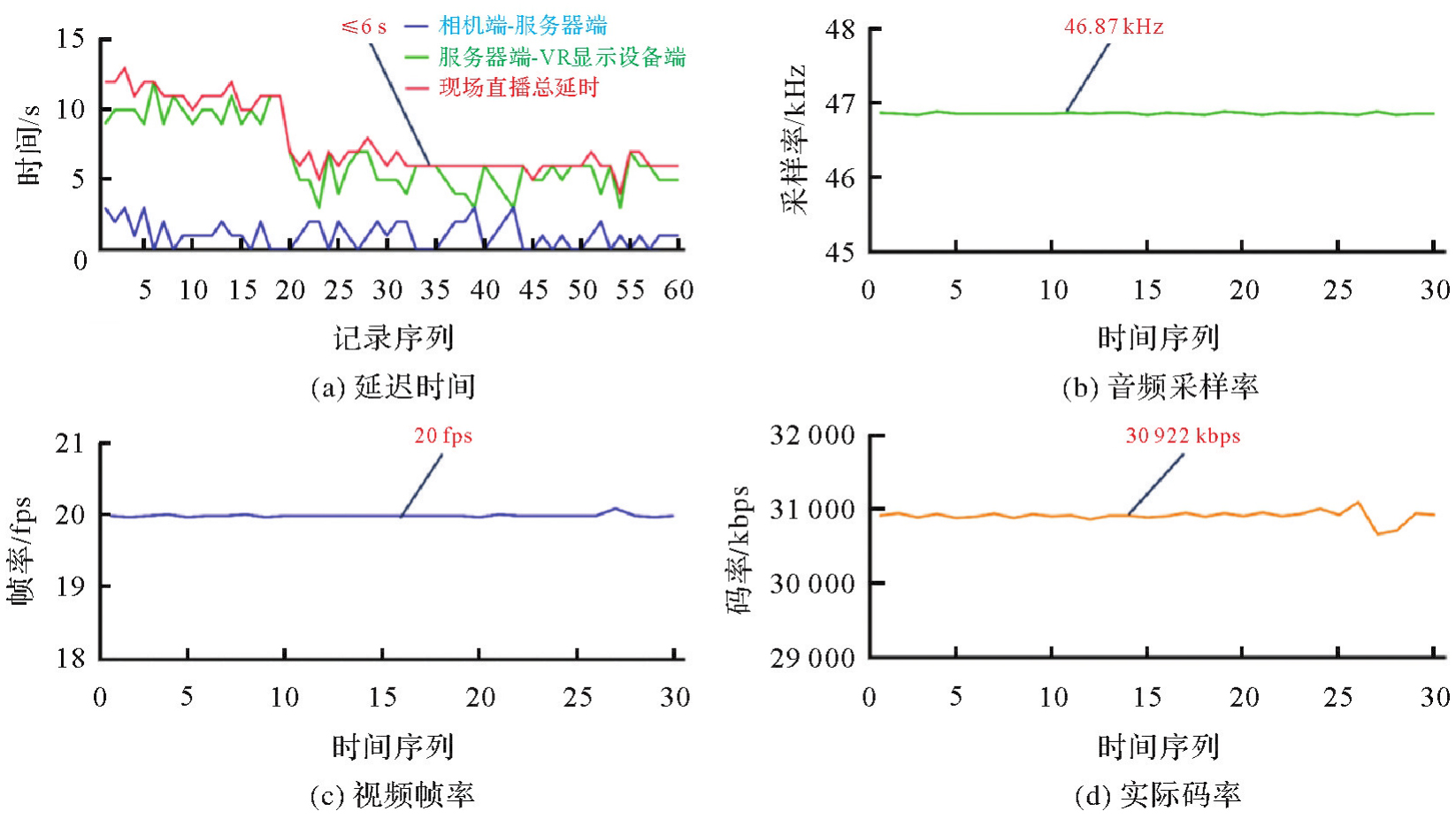
现场直播式地理信息服务在应急指挥、施工管理和环境监测等领域具备巨大的应用潜力,但传统方法难以满足用户对于现场地理信息全方位、高保真、可分析、强时效的综合感知需求。因此,本文建立了基于VR全景的现场实况远程临浸感知方法及装备系统,搭建了面向复杂地理环境的全景相机挂接云台,设计了基于全景视频的地理信息远程传输机制,提出了展示-分析-探索多级增强的现场实况远程临浸感知方法,研制了VR全景远程临浸感知装备和原型系统,开展了案例试验分析。结果表明,本文方法能够帮助远程用户沉浸式感知和分析现场地理信息,实现了复杂环境下多层级的现场直播式地理信息服务,直播延迟时间稳定在6 s左右,音视频清晰且流畅,相比其他方法在沉浸感、实时性和可分析性方面具备显著优势,为无人机VR全景技术赋能测绘地理信息服务提供了范例参考。
中图分类号:
张锦彬, 朱军, 党沛, 周宇轩, 杨博文. 现场直播式地理信息服务:基于VR全景的现场实况远程临浸感知[J]. 测绘学报, 2025, 54(12): 2276-2286.
Jinbin ZHANG, Jun ZHU, Pei DANG, Yuxuan ZHOU, Bowen YANG. Live-streaming geographic information service: remote immersive perception of on-site conditions based on VR panoramas[J]. Acta Geodaetica et Cartographica Sinica, 2025, 54(12): 2276-2286.
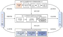
图1
总体研究思路"
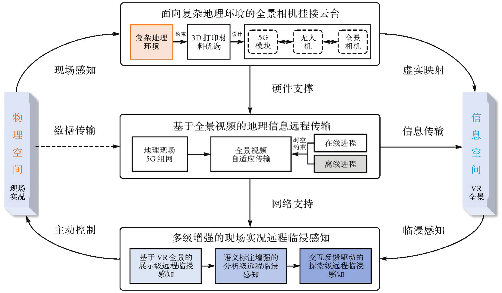
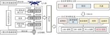
图2
全景相机挂接云台设计思路"
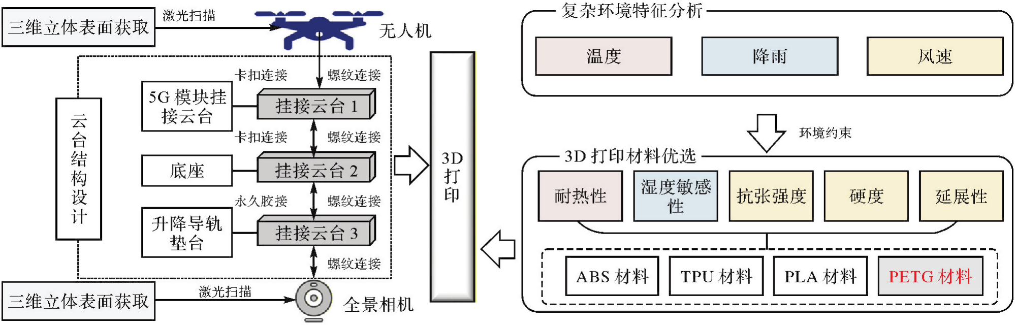
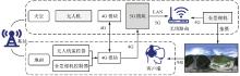
图3
基于5G的地理现场组网架构"

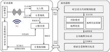
图4
基于全景视频的地理信息远程传输"
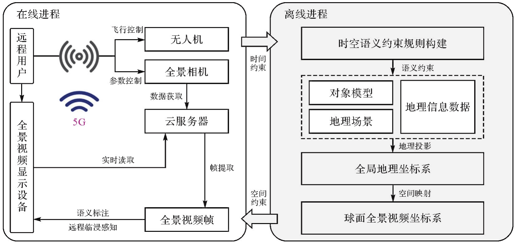
表1
属性语义信息规则"
| 层级Ⅰ | 层级Ⅱ | 层级Ⅲ | 层级Ⅳ |
|---|---|---|---|
| 地理过程 | 时间信息 | 发生时间、结束时间 | 具体地理信息 |
| 类别信息 | 暴雨洪水、溃坝洪水 | ||
| 数值信息 | 水深、流速、淹没面积 | ||
| 因果信息 | 暴雨、河道堵塞 | ||
| 空间语义属性 | 几何形状 | 长、宽、高 | |
| 坐标位置 | (B,L,H) | ||
| 地理实体 | 非空间语义属性 | 名称标识 | ***桥 |
| 从属类别 | 中承式自锚悬索桥 | ||
| 用途描述 | 铁路公路两用桥梁 | ||
| 地理过程影响 | 未被洪水淹没 |
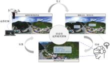
图5
探索级远程临浸感知研究思路"

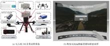
图6
装备集成与原型系统"
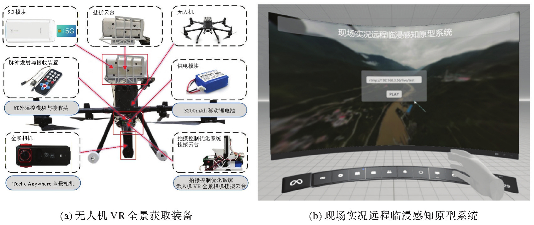
表2
软硬件信息"
| 类别 | 名称 | 详细信息 |
|---|---|---|
| 硬件 | 无人机负载平台 | 大疆M300 RTK无人机 |
| 全景采集设备 | TECHE 360Anywhere四目鱼眼全景相机 | |
| 5G模块 | 华为5G CPE Pro移动路由器、5G SIM卡 | |
| 笔记本 | 拯救者R9000P 2021版 | |
| 移动VR眼镜 | Oculus Quest 2 | |
| 3D打印设备 | 创维CR5-PRO 3D打印机 | |
| 软件 | 视频实时传输平台 | TECHE Anywhere Control |
| 视频处理编辑平台 | TECHE Anywhere Stitcher | |
| 云服务器平台 | Aliyun ECS | |
| 开发平台 | Unity 3D 2021.3.33f1c1 | |
| 开发语言 | C#、Python 3.10 |
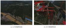
图7
展示级远程临浸感知效果"
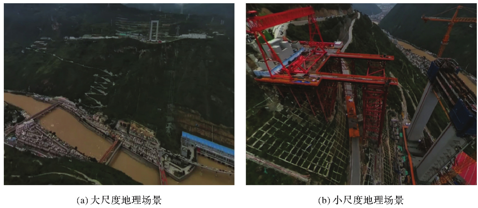

图8
分析级远程临浸感知效果"
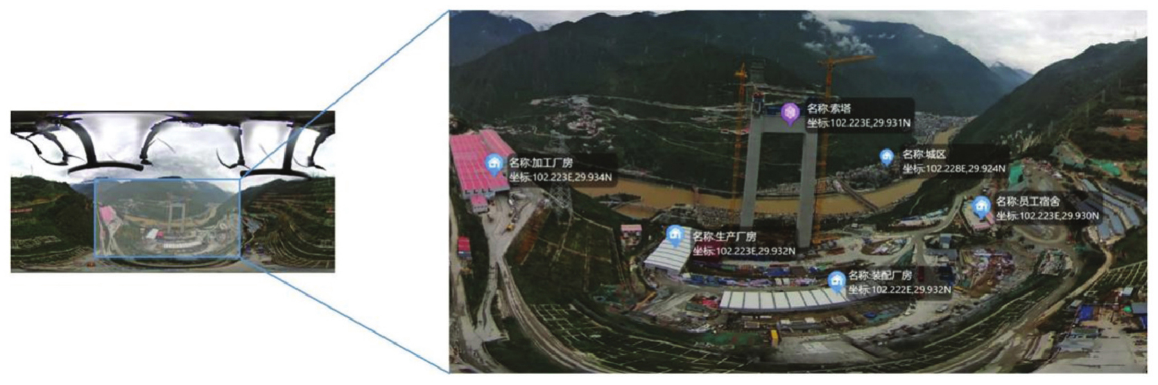
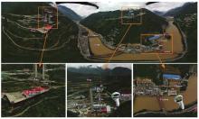
图9
探索级远程临浸感知效果"
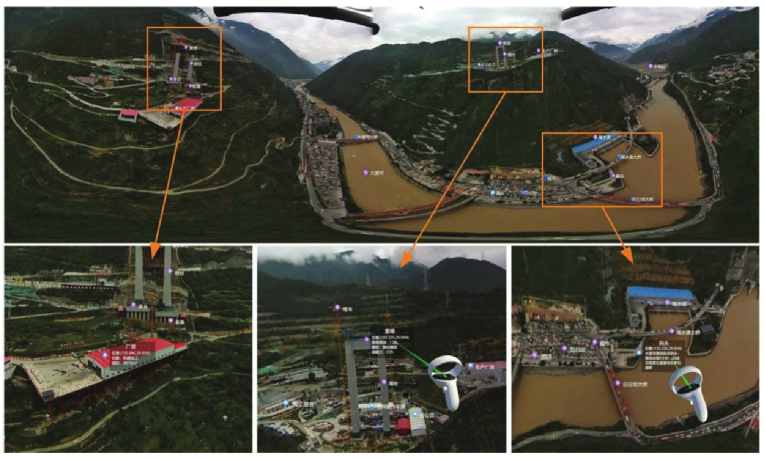
表3
现场直播式地理信息服务方法对比结果"
| 分析指标 | 基于视频图像 | 基于遥感影像 | 基于虚拟场景 | 本文方法 |
|---|---|---|---|---|
| 现场环境 | 动态/真实 | 静态/真实 | 静态/虚拟 | 动态/真实 |
| 空间信息 | 无 | 有 | 有 | 有 |
| 三维信息 | 无 | 无 | 有 | 有 |
| 语义引导 | 无 | 无 | 有 | 有 |
| 沉浸感知 | 不支持 | 不支持 | 部分支持 | 支持 |
| 远程交互 | 不支持 | 不支持 | 不支持 | 支持 |
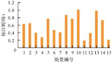
图10
VR全景地理信息标注效率"
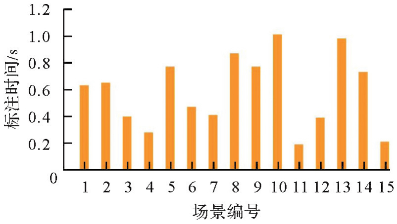
图11
VR全景视频传输效率"
| [1] | 李德仁, 邵振峰. 信息化测绘的本质是服务[J]. 测绘通报, 2008(5): 1-4. |
| LI Deren, SHAO Zhenfeng. The intrinsic property of geo-informatics is service[J]. Bulletin of Surveying and Mapping, 2008(5): 1-4. | |
| [2] |
李德仁, 徐小迪, 邵振峰. 论万物互联时代的地球空间信息学[J]. 测绘学报, 2022, 51(1): 1-8. DOI: .
doi: 10.11947/j.AGCS.2022.20210564 |
|
LI Deren, XU Xiaodi, SHAO Zhenfeng. On geospatial information science in the era of IoE[J]. Acta Geodaetica et Cartographica Sinica, 2022, 51(1): 1-8. DOI: .
doi: 10.11947/j.AGCS.2022.20210564 |
|
| [3] | 王家耀. 关于地理信息系统未来发展的思考[J]. 武汉大学学报(信息科学版), 2022, 47(10): 1535-1545. |
| WANG Jiayao. Thoughts on the future development of geographic information system[J]. Geomatics and Information Science of Wuhan University, 2022, 47(10): 1535-1545. | |
| [4] | ZHU Jun, ZHANG Jinbin, ZHU Qing, et al. A knowledge-guided visualization framework of disaster scenes for helping the public cognize risk information[J]. International Journal of Geographical Information Science, 2024, 38(4): 626-653. |
| [5] | ZHU Jun, ZHANG Jinbin, ZHU Qing, et al. Virtual geographical scene twin modeling: a combined data-driven and knowledge-driven method with bridge construction as a case study[J]. International Journal of Digital Earth, 2024, 17(1): 1-23. |
| [6] | 张永生. 现场直播式地理空间信息服务的构思与体系[J]. 测绘学报, 2011, 40(1): 1-4. |
| ZHANG Yongsheng. The conception and architecture of live-service for geospatial informationd[J]. Acta Geodaetica et Cartographica Sinica, 2011, 40(1): 1-4. | |
| [7] | 李科, 熊自明, 杜琳. 基于全景视频的虚拟地理环境建模技术研究[J]. 系统仿真学报, 2013, 25(8): 1871-1875. |
| LI Ke, XIONG Ziming, DU Lin. Research for visual geographic environment model design based on panorama video[J]. Journal of System Simulation, 2013, 25(8): 1871-1875. | |
| [8] | ZHU Yiwen, ZHANG Xumin, YAN Simin, et al. Research on spatial patterns and mechanisms of live streaming commerce in China based on geolocation data[J]. ISPRS International Journal of Geo-Information, 2023, 12(6): 229. |
| [9] | 梁美盈, 陈实. 疫情背景下地理直播课堂学习环境分析[J]. 地理教学, 2020(8): 27-30. |
| LIANG Meiying, CHEN Shi. The analysis of the learning environment of geography live classes in the context of the epidemic situation[J]. Geography Teaching, 2020(8): 27-30. | |
| [10] | 商世民, 徐祺娴. 助农直播中地理标志文化传播的空间转向[J]. 中南民族大学学报(人文社会科学版), 2022, 42(12): 82-89. |
| SHANG Shimin, XU Qixian. Spatial turn in communication of geographical indication culture in livestream advertising of agricultural products[J]. Journal of South-Central Minzu University (Humanities and Social Sciences), 2022, 42(12): 82-89. | |
| [11] | LI Yufei, XIE Yakun, CHEN Mingzhen, et al. A multi-level semantic constraint approach for highway tunnel scene twin modeling[J]. Journal of Geodesy and Geoinformation Science, 2025, 8(2): 37-56. |
| [12] | 李维森. 中国地理信息产业发展展望[J]. 资源导刊, 2024(24): 10-11. |
| LI Weisen. The development prospect of China's geographic information industry[J]. Resources Guide, 2024(24): 10-11. | |
| [13] | 徐开明. 让新质生产力成为测绘地理信息高质量发展的引擎[J]. 中国测绘, 2024(4): 19-23. |
| XU Kaiming. Making new quality productivity the engine of high-quality development of mapping and geographic information[J]. China Surveying and Mapping, 2024(4): 19-23. | |
| [14] | ZHANG Jinbin, ZHU Jun, ZHOU Yuxuan, et al. Exploring geospatial digital twins: a novel panorama-based method with enhanced representation of virtual geographic scenes in virtual reality (VR)[J]. International Journal of Geographical Information Science, 2024, 38(11): 2301-2324. |
| [15] | AO Ying, LI Penglong, Li Wen, et al. Fully convolutional networks for street furniture identification in panorama images[J]. Journal of Geodesy and Geoinformation Science, 2022, 5(4): 59-71. |
| [16] | DANG Pei, ZHU Jun, ZHOU Yuxuan, et al. A 3D-panoramic fusion flood enhanced visualization method for VR[J]. Environmental Modelling & Software, 2023, 169: 105810. |
| [17] | 李栋. 整车VR全景图生成展示系统的设计与实现[D]. 成都: 电子科技大学, 2024. |
| LI Dong. Design and implementation of vehicle VR panorama generation and display system[D]. Chengdu: University of Electronic Science and Technology of China, 2024. | |
| [18] | 陈志, 李阳靖, 罗超, 等. 空地一体多源数据融合的历史建筑数字化关键技术研究[J]. 测绘通报, 2025(S1): 179-184. |
| CHEN Zhi, LI Yangjing, LUO Chao, et al. Research on historical building surveying methods based on integrated air-ground multi-source data[J]. Bulletin of Surveying and Mapping, 2025(S1): 179-184. | |
| [19] | 叶成英, 李建微, 陈思喜. VR全景视频传输研究进展[J]. 计算机应用研究, 2022, 39(6): 1601-1607. |
| YE Chengying, LI Jianwei, CHEN Sixi. Research progress of VR panoramic video transmission[J]. Application Research of Computers, 2022, 39(6): 1601-1607. | |
| [20] | CINNAMON J, JAHIU L. 360-degree video for virtual place-based research: a review and research agenda[J]. Computers, Environment and Urban Systems, 2023, 106: 102044. |
| [21] | 黄明伟, 沈泉飞, 庄旭, 等. 轻便式全景设备在城市三维全景建设中的应用[J]. 地理空间信息, 2021, 19(9): 100-102. |
| HUANG Mingwei, SHEN Quanfei, ZHUANG Xu, et al. Application of portable panoramic equipment in urban 3D panoramic construction[J]. Geospatial Information, 2021, 19(9): 100-102. | |
| [22] | 廖小罕, 张捷, 黄耀欢. 浅析低空地理学的特征及其对地理学的拓展[J]. 地理学报, 2024, 79(3): 551-564. |
| LIAO Xiaohan, ZHANG Jie, HUANG Yaohuan. Views on characters of low-altitude airspace geography and its impact onthe geography development[J]. Acta Geographica Sinica, 2024, 79(3): 551-564. | |
| [23] | 卢嘉伟. 无人机倾斜摄影在工程项目管理决策中的应用探索[J]. 测绘与空间地理信息, 2024, 47(5): 218-220. |
| LU Jiawei. Application of UAV oblique photogrammety in engineering project management decision[J]. Geomatics & Spatial Information Technology, 2024, 47(5): 218-220. | |
| [24] | 杨铭. 空地一体遥感技术在轨道交通安全保护区巡查中的应用[J]. 测绘通报, 2024(S2): 178-181. |
| YANG Ming. The application of integrated air-ground remote sensing technology in the inspection of rail transit safety protection area[J]. Bulletin of Surveying and Mapping, 2024(S2): 178-181. | |
| [25] | 贾仕奎, 李云云, 张向阳, 等. 3D打印成型工艺及PLA材料在打印中的应用最新进展[J]. 应用化工, 2020, 49(12): 3185-3190. |
| JIA Shikui, LI Yunyun, ZHANG Xiangyang, et al. Recent progress on 3D processing methods and applications of 3D printing PLA[J]. Applied Chemical Industry, 2020, 49(12): 3185-3190. | |
| [26] | 林珲, 龚建华. 论虚拟地理环境[J]. 测绘学报, 2002, 31(1): 1-6. |
| LIN Hui, GONG Jianhua. Onvirtual geographic environments[J]. Acta Geodaetica et Cartographica Sinica, 2002, 31(1): 1-6. | |
| [27] | 林珲, 胡明远, 陈旻, 等. 从地理信息系统到虚拟地理环境的认知转变[J]. 地球信息科学学报, 2020, 22(4): 662-672. |
| LIN Hui, HU Mingyuan, CHEN Min, et al. Cognitive transformation from geographic information system to virtual geographic environments[J]. Journal of Geo-information Science, 2020, 22(4): 662-672. | |
| [28] | XU Bingli, XIAO Xin, WANG Yiqing, et al. Concept and framework of digital twin human geographical environment[J]. Journal of Environmental Management, 2025, 373: 123866. |
| [29] | 马良. 全景视频传输系统的关键技术优化研究[D]. 武汉: 华中科技大学, 2024. |
| MA Liang. Research on optimization of key technologies of panoramic video transmission system[D]. Wuhan: Huazhong University of Science and Technology, 2024. | |
| [30] | SODAGAR I. The MPEG-DASH standard for multimedia streaming over the Internet[J]. IEEE Multimedia, 2011, 18(4): 62-67. |
| [31] | LI Weilian, ZHU Jun, DANG Pei, et al. Immersive virtual reality as a tool to improve bridge teaching communication[J]. Expert Systems with Applications, 2023, 217: 119502. |
| [32] | MACEACHREN A M. Visualization in modern cartography: setting the agenda[M]//Visualization in modern cartography. New York: Pergamon, 1994: 1-12. |
| [33] | LA SALANDRA A, FRAJBERG D, FRATERNALI P. A virtual reality application for augmented panoramic mountain images[J]. Virtual Reality, 2020, 24(1): 123-141. |
| [34] | BRIVIO E, SERINO S, NEGRO COUSA E, et al. Virtual reality and 360° panorama technology: a media comparison to study changes in sense of presence, anxiety, and positive emotions[J]. Virtual Reality, 2021, 25(2): 303-311. |
| [1] | 龚健雅, 乐鹏, 向隆刚, 吴浩儒, 王凯旋, 刘瑞祥, 滕宝鑫. 开放地球引擎OGE设计与研制[J]. 测绘学报, 2025, 54(4): 587-602. |
| [2] | 彭葳, 阳靖, 付海强, 朱建军, 曾东. 顾及运动误差特性的无人机载重轨InSAR数据处理方法[J]. 测绘学报, 2025, 54(11): 1954-1967. |
| [3] | 宋瀚昀, 李昕, 黄观文, 李航. 无人机气压计测高模型精化及GNSS/SINS组合定位增强[J]. 测绘学报, 2025, 54(11): 1980-1991. |
| [4] | 闫利, 赵英豪, 戴集成, 徐博, 谢洪, 周玉泉. 面向未知环境的自主无人机智能感知测量技术[J]. 测绘学报, 2024, 53(6): 999-1012. |
| [5] | 许豪, 张勤, 王利, 舒宝, 杜源, 黄观文. 无人机抛投式GNSS滑坡监测设备智能化部署选址方法[J]. 测绘学报, 2024, 53(6): 1140-1153. |
| [6] | 姜三, 马一尘, 李清泉, 江万寿, 郭丙轩, 王力哲. 无序无人机影像的并行化SfM三维重建方法[J]. 测绘学报, 2024, 53(5): 946-958. |
| [7] | 肖腾, 王鑫, 梅熙, 叶志伟, 颜青松, 邓非. 摄影测量局部场景稳健合并的并行式运动恢复结构方法[J]. 测绘学报, 2024, 53(2): 332-343. |
| [8] | 吴华意, 赵安琪, 梁健源, 侯树洋. 面向地学分析AI建模的地理信息服务层次网络模型[J]. 测绘学报, 2024, 53(11): 2053-2063. |
| [9] | 曹子龙, 童小华, 许雄, 叶真, 肖长江. 基于空地影像多层级匹配的火星巡视器定位与地面验证[J]. 测绘学报, 2023, 52(4): 579-587. |
| [10] | 张永显, 马国锐, 崔志祥, 张志军. 面向大视角差的无人机影像序列学习型特征匹配[J]. 测绘学报, 2023, 52(2): 230-243. |
| [11] | 许强, 朱星, 李为乐, 董秀军, 戴可人, 蒋亚楠, 陆会燕, 郭晨. “天-空-地”协同滑坡监测技术进展[J]. 测绘学报, 2022, 51(7): 1416-1436. |
| [12] | 吴华意, 靳凤营, 梁健源, 张显源, 邢华桥, 桂志鹏, 李锐, 向隆刚. 地理信息服务网络与协同研究进展[J]. 测绘学报, 2022, 51(6): 1050-1061. |
| [13] | 李清泉, 黄惠, 姜三, 胡庆武, 于文率. 优视摄影测量方法及精度分析[J]. 测绘学报, 2022, 51(6): 996-1007. |
| [14] | 唐晓芳, 詹总谦, 丁久婕, 刘佳辉, 熊子柔. 顾及超像素光谱特征的无人机影像自动模糊聚类分割法[J]. 测绘学报, 2022, 51(5): 677-690. |
| [15] | 张春森, 葛英伟, 郭丙轩, 张月莹. 无人机影像DSM自动生成随机传播COLVLL算法[J]. 测绘学报, 2022, 51(11): 2346-2354. |
| 阅读次数 | ||||||
|
全文 |
|
|||||
|
摘要 |
|
|||||