

Acta Geodaetica et Cartographica Sinica ›› 2024, Vol. 53 ›› Issue (4): 761-772.doi: 10.11947/j.AGCS.2024.20230308
• Cartography and Geoinformation • Previous Articles Next Articles
Fei ZHAO1,2( ), Zhaozheng LI3, Quan GAN4, Zuyu GAO3, Zhanchu WANG3, Qingyun DU5, Zhensheng WANG6, Yang SHEN4, Wei PAN7()
Received:2023-07-05
Revised:2024-02-22
Published:2024-05-13
Contact:
Wei PAN
E-mail:cartographer@ynu.edu.cn;panwei@ynu.edu.cn
About author:ZHAO Fei (1986—), male, PhD, associate professor, majors in cartography theory & application and spatio-temporal big data analysis. E-mail: cartographer@ynu.edu.cn
Supported by:CLC Number:
Fei ZHAO, Zhaozheng LI, Quan GAN, Zuyu GAO, Zhanchu WANG, Qingyun DU, Zhensheng WANG, Yang SHEN, Wei PAN. A method for hydrological information extraction from historical maps combining SAM large model and mathematical morphology[J]. Acta Geodaetica et Cartographica Sinica, 2024, 53(4): 761-772.
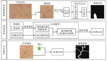
Fig. 1
Flowchart of hydrological information extraction from historical maps"

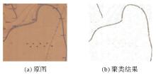
Fig. 2
Results of FCM clustering"
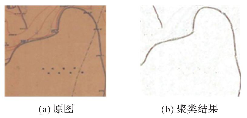
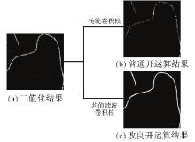
Fig. 3
Comparison of open operation results"
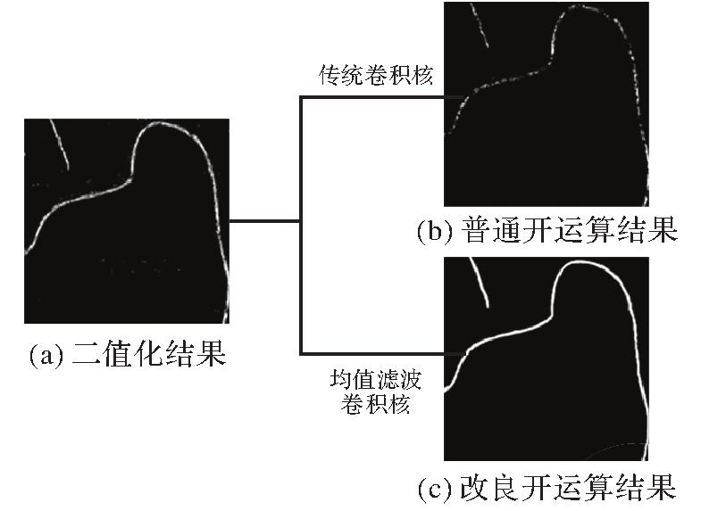

Fig. 4
Structure of image encoder"
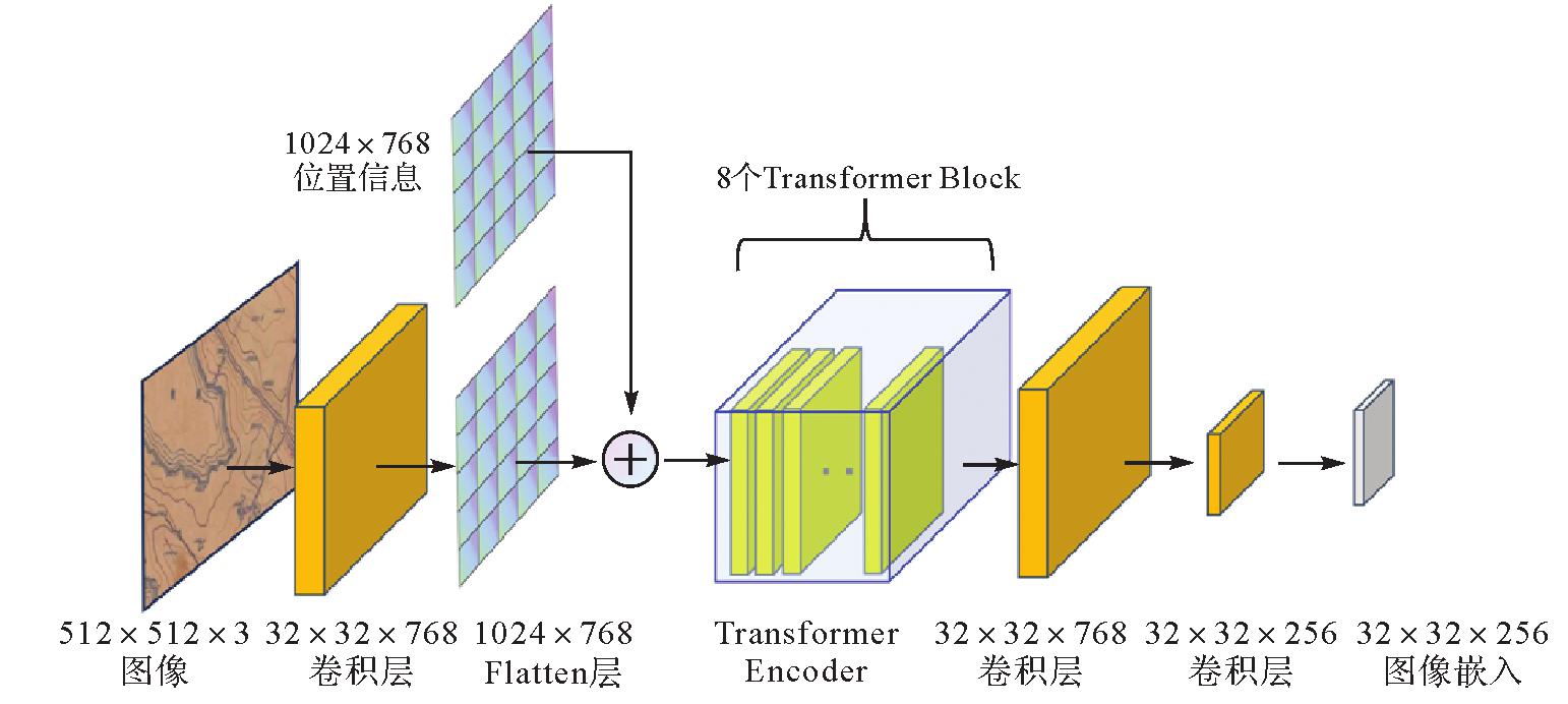
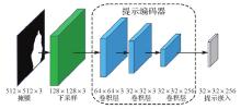
Fig. 5
Structure of prompt encoder"

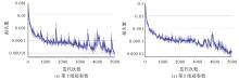
Fig. 6
Loss function curves of different hyperparameters"
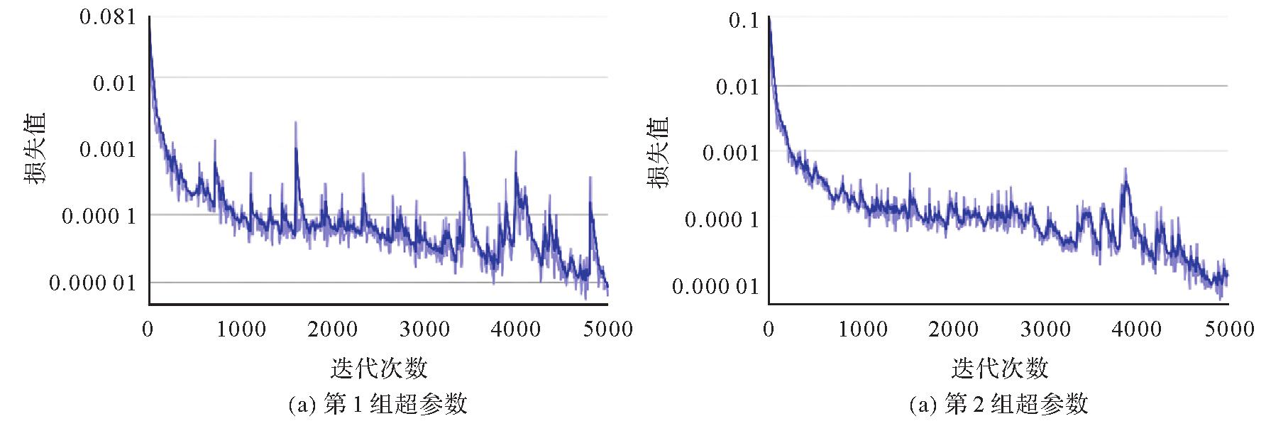
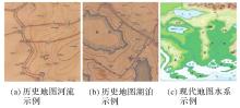
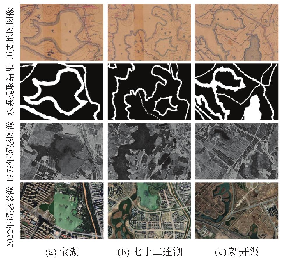
Fig. 7
The comparison of hydrological representation between historical maps and modern maps"
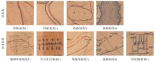
Fig. 8
Tag classification"
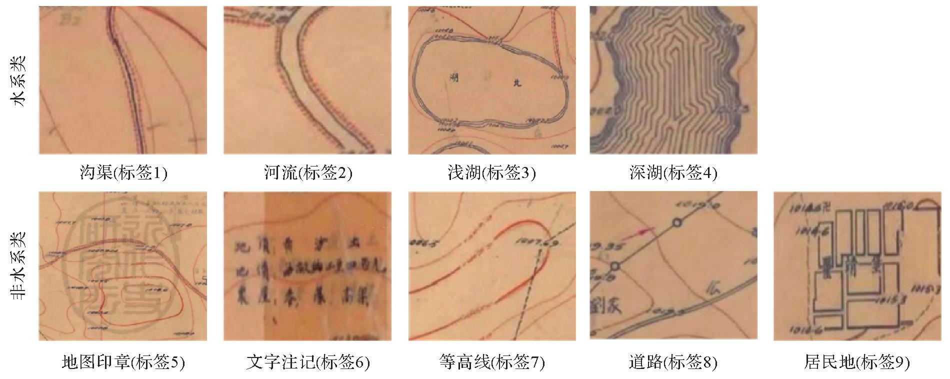
Tab. 1
Number of tags in different categories"
| 标签类别 | 数量 | 占比/(%) |
|---|---|---|
| 沟渠 | 186 | 88.57 |
| 河流 | 59 | 28.10 |
| 浅湖 | 151 | 71.90 |
| 深湖 | 33 | 15.71 |
| 地图印章 | 15 | 7.14 |
| 文字注记 | 210 | 100.00 |
| 等高线 | 210 | 100.00 |
| 道路 | 91 | 43.30 |
| 居民地 | 118 | 56.19 |
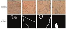
Fig. 9
Dataset example"

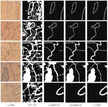
Fig. 10
Visual comparison of multi-model hydrological information extraction effects"

Tab. 2
Comparison of multi-model water system extraction accuracy"
| 模型 | 准确率 | IoU | 精度 | F1值 |
|---|---|---|---|---|
| U-Net | 84.31 | 61.62 | 62.32 | 76.48 |
| 原始SAM | 89.68 | 76.65 | 84.70 | 84.40 |
| 改进SAM | 94.13 | 83.25 | 91.18 | 90.86 |
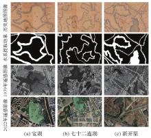
Fig. 11
Comparison of hydrological information extraction results with modern remote sensing images"
| [1] | 王光霞, 游雄, 於建峰, 等.地图设计与编绘[M].北京: 测绘出版社, 2014. |
| WANG Guangxia, YOU Xiong, YU Jianfeng, et al. Map design and compilation[M]. Beijing: Surveying and Mapping Press, 2014. | |
| [2] | 翁敏, 黄谦, 苏世亮, 等. 基于皮尔斯符号三元观的专题地图符号设计[J]. 测绘地理信息, 2021, 46(1):44-47. |
| WENG Min, HUANG Qian, SU Shiliang, et al. Design of thematic map symbols based on Peirce's semiotic triangle[J]. Journal of Geomatics, 2021, 46(1):44-47. | |
| [3] | 王家耀, 武芳, 闫浩文. 大变化时代的地图学[J]. 测绘学报, 2022, 51(6):829-842. DOI: 10.11947/j.AGCS.2022.20210661. |
| WANG Jiayao, WU Fang, YAN Haowen. Cartography: its past, present and future[J]. Acta Geodaetica et Cartographica Sinica, 2022, 51(6):829-842. DOI: 10.11947/j.AGCS.2022.20210661. | |
| [4] | 赵飞, 杜清运, 任福, 等. 专题地图符号的句法结构及其自动构建机制[J]. 测绘学报, 2014, 43(6):653-660. DOI: 10.13485/j.cnki.11-2089.2014.0105. |
| ZHAO Fei, DU Qingyun, REN Fu, et al. Syntactic characteristics and smart construction mechanism of thematic map symbol[J]. Acta Geodaetica et Cartographica Sinica, 2014, 43(6):653-660. DOI: 10.13485/j.cnki.11-2089.2014.0105. | |
| [5] | PAL N R, PAL S K. A review on image segmentation techniques[J]. Pattern Recognition, 1993, 26(9):1277-1294. |
| [6] | ZHONG D X, YAN H. Color image segmentation using color space analysis and fuzzy clustering[C]//Proceedings of 2000 IEEE Signal Processing Society Workshop. Sydney: IEEE, 2000: 624-633. |
| [7] | LIU Tiange, XU Pengfei, ZHANG Shihui. A review of recent advances in scanned topographic map processing[J]. Neurocomputing, 2019, 328:75-87. |
| [8] | LEVACHKINE S, VELÀZQUEZ A, ALEXANDROV V, et al. Semantic analysis and recognition of raster-scanned color cartographic images[C]//Proceedings of 2001 International Workshop on Graphics Recognition. Berlin: Springer, 2001: 178-189. |
| [9] | KHOTANZAD A, BOUARFA A. Image segmentation by a parallel, non-parametric histogram based clustering algorithm[J]. Pattern Recognition, 1990, 23(9):961-973. |
| [10] | 于子娟. 基于模糊C均值聚类的彩色图像分割方法研究[D]. 长沙: 中南大学, 2009. |
| YU Zijuan. Research on color image segmentation method based on fuzzy C-means clustering[D]. Changsha: Central South University, 2009. | |
| [11] | 郑华利, 周献中, 王建宇. 基于色彩空间转换及模糊约束聚类的地形图自动分色[J]. 测绘学报, 2003, 32(2):183-187. |
| ZHENG Huali, ZHOU Xianzhong, WANG Jianyu. Automatic color segmentation of topographic maps based on color space transformation and fuzzy restraint clustering[J]. Acta Geodaetica et Cartographic Sinica, 2003, 32(2):183-187. | |
| [12] | LIM Y W, LEE S U. On the color image segmentation algorithm based on the thresholding and the fuzzy C-means techniques[J]. Pattern Recognition, 1990, 23(9):935-952. |
| [13] | 林开颜, 徐立鸿, 吴军辉. 快速模糊C均值聚类彩色图像分割方法[J]. 中国图象图形学报, 2004, 9(2):159-163. |
| LIN Kaiyan, XU Lihong, WU Junhui. A fast fuzzy C-means clustering for color image segmentation[J]. Journal of Image and Graphics, 2004, 9(2):159-163. | |
| [14] | 郑华利, 周献中, 王建宇. 空间关系信息和颜色信息相结合的地形图分层算法[J]. 中国图象图形学报, 2003, 8(3):334-340. |
| ZHENG Huali, ZHOU Xianzhong, WANG Jianyu. Automatic color segmentation of topographic maps based on the combination of spatial relation information and color information[J]. Journal of Image and Graphics, 2003, 8(3):334-340. | |
| [15] | KHOTANZAD A, ZINK E. Contour line and geographic feature extraction from USGS color topographical paper maps[J]. IEEE Transactions on Pattern Analysis and Machine Intelligence, 2003, 25(1):18-31. |
| [16] | GHIRCOIAS T, BRAD R. Contour lines extraction and reconstruction from topographic maps[J]. Ubiquitous Computing and Communication Journal, 2011, 6(2):681-691. |
| [17] | ZHANG Xiaoyu, CHEN Jiusheng, DONG Jiankang. Color clustering using self-organizing maps[C]//Proceedings of 2007 International Conference on Wavelet Analysis and Pattern Recognition. Beijing: IEEE, 2007: 986-989. |
| [18] | WANG Ming, YU Zhiwei, GUO Chengman, et al. Study on the method of generating digital elevation topographic map in the MATLAB[J]. Advanced Materials Research, 2012, 594/595/596/597:2902-2905. |
| [19] | MIAO Qiguang, XU Pengfei, LIU Tiange, et al. Linear feature separation from topographic maps using energy density and the shear transform[J]. IEEE Transactions on Image Processing, 2013, 22(4):1548-1558. |
| [20] | 田宽. 彩色地形图中的点状符号识别算法研究[D]. 西安: 西安电子科技大学, 2017. |
| TIAN Kuan. Research on point symbols recognition in color topographic map[D]. Xi'an: Xidian University, 2017. | |
| [21] | 崔腾腾, 刘纪平, 罗安. 一种卷积神经网络的地图图片智能识别方法[J]. 测绘科学, 2019, 44(1):118-123. |
| CUI Tengteng, LIU Jiping, LUO An. Intelligent identification method of network map images based on convolutional neural network[J]. Science of Surveying and Mapping, 2019, 44(1):118-123. | |
| [22] | 任加新, 刘万增, 李志林, 等. 利用卷积神经网络进行“问题地图” 智能检测[J]. 武汉大学学报(信息科学版), 2021, 46(4):570-577. |
| REN Jiaxin, LIU Wanzeng, LI Zhilin, et al. Intelligent detection of “problematic map” using convolutional neural network[J]. Geomatics and Information Science of Wuhan University, 2021, 46(4):570-577. | |
| [23] | 李想. 基于深度学习的地图点注记识别及配置研究[D]. 郑州: 郑州大学, 2022. |
| LI Xiang. Research on map point annotation recognition and configuration based on deep learning[D].Zhengzhou: Zhengzhou University, 2022. | |
| [24] | 周翰林. 基于深度学习的GIS图例符号识别系统研建[D]. 北京: 北京林业大学, 2018. |
| ZHOU Hanlin. Study on GIS similar legend recognition system based on deep learning[D]. Beijing: Beijing Forestry University, 2018. | |
| [25] | 闫晓婧, 闫浩文, 王小龙, 等. 微地图符号的智能化匹配:“识图配符”[J]. 测绘科学, 2022, 47(10):205-212. |
| YAN Xiaojing, YAN Haowen, WANG Xiaolong, et al. An intelligent symbol matching solution for we-maps through image recognition[J]. Science of Surveying and Mapping, 2022, 47(10):205-212. | |
| [26] | ZHANG C, LIU L, CUI Y, et al. A comprehensive survey on segment anything model for vision and beyond[EB/OL]. [2023-06-10].https://arxiv.org/pdf/2305.08196.pdf. |
| [27] | 张良培, 张乐飞, 袁强强. 遥感大模型:进展与前瞻[J]. 武汉大学学报(信息科学版), 2023, 48(10):1574-1581. |
| ZHANG Liangpei, ZHANG Lefei, YUAN Qiangqiang. Large remote sensing model: progress and prospects[J]. Geomatics and Information Science of Wuhan University, 2023, 48(10):1574-1581. | |
| [28] | WANG Yi, ALBRECHT C M, ZHU Xiaoxiang. Self-supervised vision transformers for joint SAR-optical representation learning[EB/OL]. [2023-06-10]. https://arxiv.org/pdf/2204.05381.pdf. |
| [29] | REED C J, GUPTA R, LI Shufan, et al. Scale-MAE: a scale-aware masked autoencoder for multiscale geospatial representation learning[C]///Proceedings of 2023 IEEE/CVF International Conference on Computer Vision. Paris: IEEE, 2023: 4088-4099. |
| [30] | KIRILLOV A, MINTUN E, RAVI N, et al. Segment anything[EB/OL]. [2023-06-10].https://doi.org/10.48550/arXiv.2304.02643. |
| [31] | JIE L, ZHANG H. When SAM meets shadow detection[EB/OL]. [2023-06-10].https://arxiv.org/pdf/2305.11513.pdf. |
| [32] | PAL N R, BEZDEK J C. On cluster validity for the fuzzy c-means model[J]. IEEE Transactions on Fuzzy Systems, 1995, 3(3):370-379. |
| [33] | ZHAO Fei, DU Qingyun, REN Fu, et al. Syntactic characteristics and a smart construction mechanism for thematic map symbols[J]. Journal of Geodesy and Geoinformation Science, 2019, 2(1):37-48. |
| [34] | RIPLEY B D, MATHERON G. Random sets and integral geometry[J]. Journal of the Royal Statistical Society, 1976, 139(2):277-278. |
| [35] | SERRA J. Introduction to mathematical morphology[J]. Computer Vision, Graphics, and Image Processing, 1986, 35(3):283-305. |
| [36] | DOSOVITSKIY A, BEYER L, KOLESNIKOV A, et al. An image is worth 16×16 words: transformers for image recognition at scale[EB/OL]. [2023-06-10]. https://arxiv.org/pdf/2010.11929.pdf. |
| [37] | VASWANI A, SHAZEER N, PARMAR N, et al. Attention is all you need[C]//Proceedings of the 31st International Conference on Neural Information Processing Systems. Long Beach: ACM Press, 2017: 6000-6010. |
| [38] | LIN T Y, GOYAL P, GIRSHICK R, et al. Focal loss for dense object detection[C]//Proceedings of 2017 IEEE International Conference on Computer Vision. Venice: IEEE, 2017: 2980-2988. |
| [39] | ZHAO Yao, WANG Guangxia, YANG Jian, et al. Building block extraction from historical maps using deep object attention networks[J]. ISPRS International Journal of Geo-Information, 2022, 11(11):572. |
| Viewed | ||||||
|
Full text |
|
|||||
|
Abstract |
|
|||||