

Acta Geodaetica et Cartographica Sinica ›› 2024, Vol. 53 ›› Issue (4): 599-609.doi: 10.11947/j.AGCS.2024.20230357
• Real-time Remote Sensing Mapping • Previous Articles Next Articles
Mi WANG1( ), Beibei GUO1(), Yingdong PI1, Zhiqi ZHANG2, Jing XIAO3, Rongfan DAI1, Shao XIANG1
Received:2023-09-04
Revised:2024-02-18
Published:2024-05-13
Contact:
Beibei GUO
E-mail:wangmi@whu.edu.cn;gbb_whu@whu.edu.cn
About author:WANG Mi (1974—), male, PhD, professor, PhD supervisor, majors in high-resolution optical satellite imagery data processing and intelligent service. E-mail: wangmi@whu.edu.cn
Supported by:CLC Number:
Mi WANG, Beibei GUO, Yingdong PI, Zhiqi ZHANG, Jing XIAO, Rongfan DAI, Shao XIANG. On-orbit processing technology and verification of Luojia-3 01 satellite[J]. Acta Geodaetica et Cartographica Sinica, 2024, 53(4): 599-609.
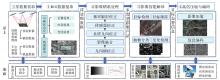
Fig. 1
Task-driven on-orbit processing framework"
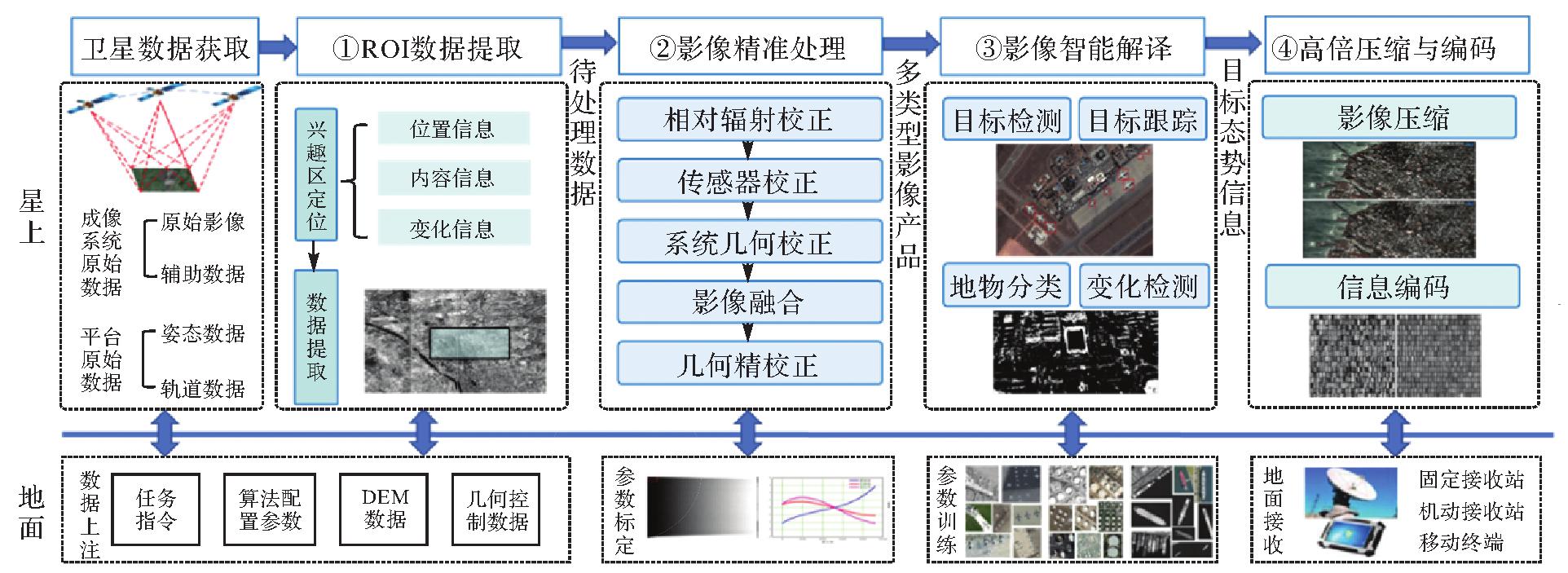
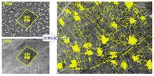
Fig. 2
Distribution of control points for geometric calibration"
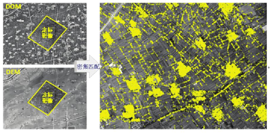
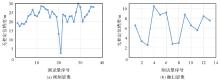
Fig. 3
Geometric positioning accuracy of test images"
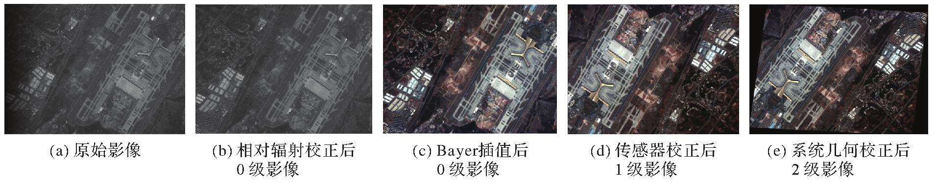
Fig. 4
Original image and 0~2 level product images"
Tab. 1
Test results of relative radiation correction accuracy"
| 地物类型 | 序号 | 广义噪声/(%) | |
|---|---|---|---|
| 原始影像 | 辐射校正后影像 | ||
| 海洋 | 1 | 9.56 | 2.05 |
| 2 | 10.38 | 1.09 | |
| 3 | 10.04 | 1.15 | |
| 陆地 | 1 | 10.80 | 1.72 |
| 2 | 11.17 | 1.62 | |
| 3 | 9.93 | 2.57 | |
Tab. 2
Test results of internal geometric accuracy"
| 影像 | 成像时间 | 中心经纬度 | 内部几何精度/像素 | ||
|---|---|---|---|---|---|
| 沿轨方向 | 垂轨方向 | 平面 | |||
| Test1 | 2023-04-30 | 109.94°E,41.99°N | 0.864 | 0.603 | 1.054 |
| Test2 | 2023-04-30 | 109.60°E,40.79°N | 0.777 | 0.950 | 1.227 |
| Test3 | 2023-05-01 | 44.67°E,34.39°N | 1.024 | 0.786 | 1.291 |
| Test4 | 2023-05-01 | 44.04°E,32.13°N | 0.872 | 0.990 | 1.319 |
| Test5 | 2023-05-03 | 33.84°E,45.04°N | 0.675 | 1.041 | 1.241 |
| Test6 | 2023-05-03 | 33.67°E,44.57°N | 0.777 | 1.001 | 1.267 |
Tab. 3
Comparison of processing time for image products"
| 方法 | 影像大小/像素 | 相对辐射校正耗时/s | 传感器校正耗时/s | 系统几何校正耗时/s | 总耗时/s | 加速比 |
|---|---|---|---|---|---|---|
| 传统标准景方法 | 4000×4000 | 11.045 | 166.837 | 379.988 | 557.870 | 1.0 |
| 面向ROI方法 | 4000×4000 | 3.353 | 0.838 | 0.108 | 4.300 | 129.7 |
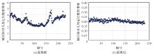
Fig. 5
Relative geometric accuracy between frames before and after video image stabilization"
Tab. 4
Object detecting accuracy"
| 目标 | 发现率/(%) | 虚警率/(%) |
|---|---|---|
| 飞机 | 96.61 | 4.35 |
| 油桶 | 95.24 | 5.05 |
| 船舶 | 94.54 | 5.56 |
| 平均 | 95.46 | 4.98 |
Tab. 5
Object detecting time"
| 影像 | 图像大小/像素 | 检测耗时/s |
|---|---|---|
| 1 | 2000×2000 | 0.051 |
| 2 | 2000×2000 | 0.049 |
| 3 | 2000×2000 | 0.050 |
| 4 | 2000×2000 | 0.052 |
| 平均值 | 0.051 | |
Tab. 6
Moving object tracking accuracy and efficiency"
| 视频名称 | 图像大小/像素 | 跟踪精度/(%) | 跟踪耗时/s |
|---|---|---|---|
| 港口1 | 980×1238 | 91 | 0.025 |
| 港口2 | 3328×1832 | 85 | 0.040 |
| 机场1 | 5304×3008 | 86 | 0.067 |
| 机场2 | 1536×1080 | 95 | 0.033 |
| 平均值 | 89 | 0.041 | |

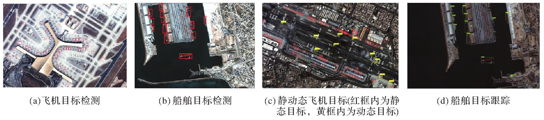
Fig. 6
Typical target detection and tracking results"
Tab. 7
Test results of static image compression"
| 图像名称 | 图像大小/像素 | 压缩耗时/s | 压缩倍数 | PSNR/dB | SSIM |
|---|---|---|---|---|---|
| 迪拜 | 3840×2160 | 0.388 | 30.20 | 36.304 | 0.927 |
| 港口 | 3840×2160 | 0.463 | 42.00 | 36.200 | 0.923 |
| 机场 | 3840×2160 | 0.351 | 30.30 | 36.559 | 0.927 |
| 拉萨 | 3840×2160 | 0.392 | 31.90 | 36.450 | 0.942 |
| 马斯喀特 | 3840×2160 | 0.377 | 32.33 | 36.397 | 0.901 |
Tab. 8
Test results of video image compression"
| 图像名称 | 图像大小/像素 | 压缩耗时/s | 压缩倍数 | PSNR/dB | SSIM |
|---|---|---|---|---|---|
| 迪拜 | 1920×1080 | 0.067 | 217.3 | 37.4 | 0.93 |
| 港口 | 2664×1520 | 0.067 | 211.3 | 39.5 | 0.95 |
| 机场 | 1920×1080 | 0.063 | 207.4 | 36.2 | 0.89 |
| 拉萨 | 1976×1136 | 0.063 | 220.0 | 37.2 | 0.94 |
| 马斯喀特 | 2360×1344 | 0.071 | 212.6 | 37.2 | 0.91 |
Fig. 7
Static image on-orbit compression results"
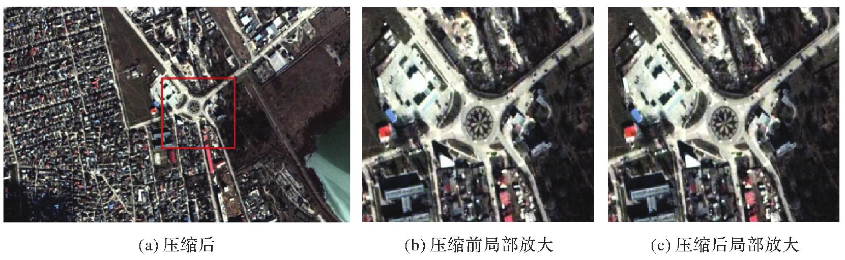
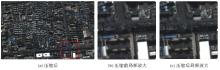
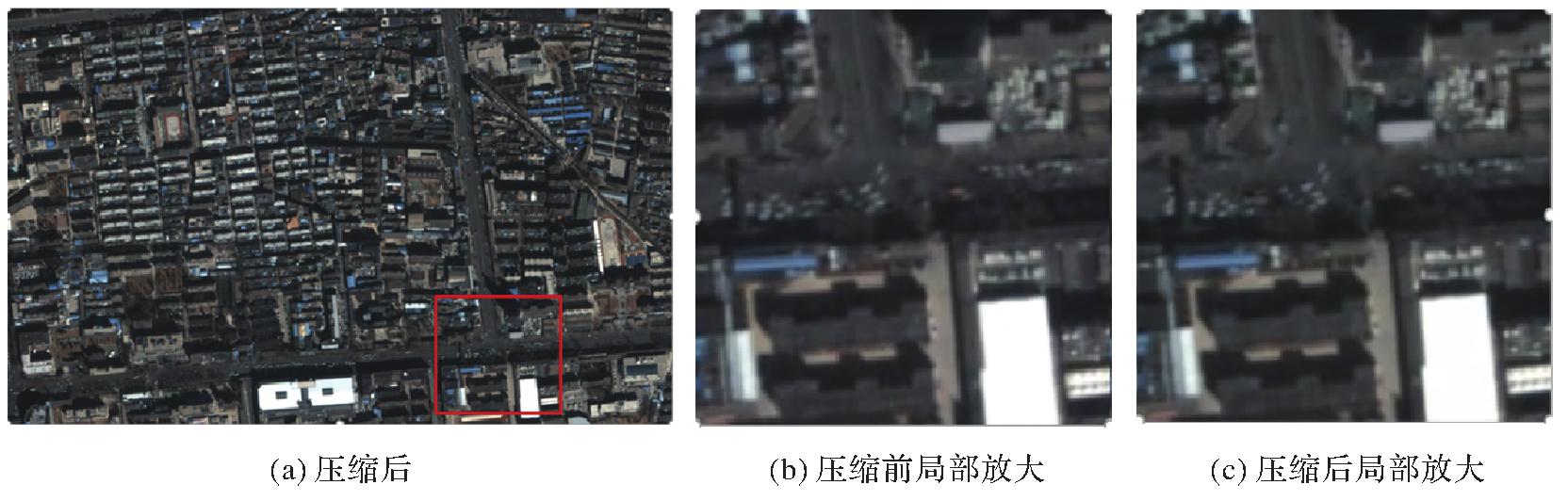
Fig. 8
Video image on-orbit compression results"
| [1] | 李劲东. 中国高分辨率对地观测卫星遥感技术进展[J]. 前瞻科技, 2022, 1(1):112-125. |
| LI Jindong. Advances in high-resolution earth observation satellite remote sensing technologies in China[J]. Science and Technology Foresight, 2022, 1(1):112-125. | |
| [2] | 赵坚, 孟令杰, 王琦, 等. 我国高分辨率对地观测系统建设与发展[J]. 卫星应用, 2022, 131(11):8-13. |
| ZHAO Jian, MENG Lingjie, WANG Qi, et al. Construction and development of high resolution earth observation system in China[J]. Satellite Application, 2022, 131(11):8-13. | |
| [3] | 赵文波, 李帅, 李博, 等. 新一代体系效能型对地观测体系发展战略研究[J]. 中国工程科学, 2021, 23(6):128-138. |
| ZHAO Wenbo, LI Shuai, LI Bo, et al. Development strategy of the new-generation effectiveness-oriented earth-observation system[J]. Strategic Study of CAE, 2021, 23(6):128-138. | |
| [4] | 李德仁. 从珞珈系列卫星到东方慧眼星座[J]. 武汉大学学报(信息科学版), 2023, 48(10):1557-1565. |
| LI Deren. From the Luojia series satellites to the oriental smart eye constellation[J]. Geomatics and Information Science of Wuhan University, 2023, 48(10):1557-1565. | |
| [5] | 杨芳, 刘思远, 赵键, 等. 新型智能遥感卫星技术展望[J]. 航天器工程, 2017, 26(5):74-81. |
| YANG Fang, LIU Siyuan, ZHAO Jian, et al. Technology prospective of intelligent remote sensing satellite[J]. Spacecraft Engineering, 2017, 26(5):74-81. | |
| [6] | 张兵. 智能遥感卫星系统[J]. 遥感学报, 2011, 15(3):415-431. |
| ZHANG Bing. Intelligent remote sensing satellite system[J]. Journal of Remote Sensing, 2011, 15(3):415-431. | |
| [7] | 李德仁, 王密, 杨芳. 新一代智能测绘遥感科学试验卫星珞珈三号01星[J]. 测绘学报, 2022, 51(6):789-796.DOI: 10.11947/j.AGCS.2022.20220184. |
| LI Deren, WANG Mi, YANG Fang. A new generation of intelligent mapping and remote sensing scientific test satellite Luojia-3 01[J]. Acta Geodaetica et Cartographica Sinica, 2022, 51(6):789-796. DOI: 10.11947/j.AGCS.2022.20220184. | |
| [8] | 乔凯, 智喜洋, 王达伟, 等. 星上智能信息处理技术发展趋势分析与若干思考[J]. 航天返回与遥感, 2021, 42(1):21-27. |
| QIAO Kai, ZHI Xiyang, WANG Dawei, et al. Analysis and some thoughts on the development trend of the on-board intelligent information processing technology[J]. Spacecraft Recovery & Remote Sensing, 2021, 42(1):21-27. | |
| [9] | 王密, 杨芳. 智能遥感卫星与遥感影像实时服务[J]. 测绘学报, 2019, 48(12):1586-1594.DOI: 10.11947/j.AGCS.2019.20190454. |
| WANG Mi, YANG Fang. Intelligent remote sensing satellite and remote sensing image real-time service[J]. Acta Geodaetica et Cartographica Sinica, 2019, 48(12):1586-1594. DOI: 10.11947/j.AGCS.2019.20190454. | |
| [10] | 李刚, 刘瑜, 张庆君. 多源卫星数据在轨智能融合技术[J]. 中国科学基金, 2021, 35(5):708-712. |
| LI Gang, LIU Yu, ZHANG Qingjun. On the development of on-board fusion of multi-source satellite data[J]. Bulletin of National Na-tural Science Foundation of China, 2021, 35(5):708-712. | |
| [11] | ZHOU Guoqing. Future intelligent Earth observing satellites[C]//Proceedings of 2003 Earth Observing Systems. San Diego: SPIE, 2003. |
| [12] | CRISP N, SMITH K, HOLLINGSWORTH P. Small satellite launch to LEO: a review of current and future launch system[J]. Tran-sactions of Japan Society for Aeronautical and Space Sciences, Aerospace Technology Japan, 2014, 12(29):39-47. |
| [13] | VANCE L, WOIDA R, STALLINGS J. Responsive imaging surveillance using CubeSat technologies derived from the DARPA SeeMe project[C]//Proceedings of the 28th Annual AIAA/USU Conference on Small Satellites. Logan: AIAA, 2014. |
| [14] | SCARDERA M, BAKER M, REYNOLDS R, et al. ALTAIR: millennium's DARPA seeme satellite solution technical evolution[C]//Proceedings of the 28th Annual AIAA/USU Conference on Small Satellites. Logan: AIAA, 2014. |
| [15] | 李德仁. 论“互联网+” 天基信息服务[J]. 遥感学报, 2016, 20(5):708-715. |
| LI Deren. The “Internet Plus” space-based information services[J]. Journal of Remote Sensing, 2016, 20(5):708-715. | |
| [16] | 李德仁, 沈欣, 李迪龙, 等. 论军民融合的卫星通信、遥感、导航一体天基信息实时服务系统[J]. 武汉大学学报(信息科学版), 2017, 42(11):1501-1505. |
| LI Deren, SHEN Xin, LI Dilong, et al. On civil-military integrated space-based real-time information service system[J]. Geomatics and Information Science of Wuhan University, 2017, 42(11):1501-1505. | |
| [17] | 李德仁, 王密, 沈欣, 等. 从对地观测卫星到对地观测脑[J]. 武汉大学学报(信息科学版), 2017, 42(2):143-149. |
| LI Deren, WANG Mi, SHEN Xin, et al. From earth observation satellite to earth observation brain[J]. Geomatics and Information Science of Wuhan University, 2017, 42(2):143-149. | |
| [18] | MACKEY R, BROWNSTON L, P CASTLE J, et al. Getting diagnostic reasoning off the ground: maturing technology with TacSat-3[J]. IEEE Intelligent Systems, 2010, 25(5):27-35. |
| [19] | LORENZ E, HALLE W, FISCHER C, et al. Recent results of the firebird mission[C]//Proceedings of the 37th International Symposium on Remote Sensing of Environment. Tshwane: [s.n.], 2017. |
| [20] | FISCHER C, KLEIN D, KERR G, et al. Data validation and case studies using the TET-1 thermal infrared satellite system[C]//Proceeding of the 36th International Symposium on Remote Sensing of Environment. Berlin: [s.n.], 2015. |
| [21] | MARTIN V, BLANCHETG, KUBIK P, et al. PLEIADES-HR 1A&1B image quality commissioning: innovative radiometric calibration methods and results[C]//Proceedings of 2013 Earth Observing Systems XVIII. California: SPIE, 2013. |
| [22] | 贺小军, 李竺强, 秦小宝, 等. 吉林一号光谱卫星技术创新与应用成果[J]. 卫星应用, 2020(3):18-26. |
| HE Xiaojun, LI Zhuqiang, QIN Xiaobao, et al. Technological innovation and application achievements of Jilin-1 spectral satellite[J]. Satellite Application, 2020(3):18-26. | |
| [23] | 汪精华, 王跃, 于龙江, 等. 高分多模卫星星地一体化快速响应系统设计与在轨验证[J]. 航天器工程, 2021, 30(3):58-63. |
| WANG Jinghua, WANG Yue, YU Longjiang, et al. Design and on-orbit verification of ground-to-satellite integrated system supporting rapid response of GFDM-1 satellite[J]. Spacecraft Engineering, 2021, 30(3):58-63. | |
| [24] | ZHANG Bing, WU Yuanfeng, ZHAO Boya, et al. Progress and challenges in intelligent remote sensing satellite systems[J]. IEEE Journal of Selected Topics in Applied Earth Observations and Remote Sensing, 2022, 15:1814-1822. |
| [25] | LI Deren, WANG Mi, YANG Fang, et al. Internet intelligent remote sensing scientific experimental satellite LuoJia3-01[J]. Geo-spatial Information Science, 2023, 26(3):257-261. |
| [26] | 李琳, 岳文振, 葛礼晖, 等. 光学遥感微纳卫星在轨实时信息处理系统[J]. 南京航空航天大学学报, 2018, 50(S1):108-111. |
| LI Lin, YUE Wenzhen, GE Lihui, et al. In-orbit real-time information processing system for optical remote sensing micro/nano satellites[J]. Journal of Nanjing University of Aeronautics & Astronautics, 2018, 50(S1):108-111. | |
| [27] | 王兆魁, 方青云, 韩大鹏. 成像卫星在轨智能处理技术研究进展[J]. 宇航学报, 2022, 43(3):259-270. |
| WANG Zhaokui, FANG Qingyun, HAN Dapeng. Research progress of on-orbit artificial intelligence technology for imaging satellite[J]. Journal of Astronautics, 2022, 43(3):259-270. | |
| [28] | 王密, 仵倩玉. 面向星群的遥感影像智能服务关键问题[J]. 测绘学报, 2022, 51(6):1008-1016.DOI: 10.11947/j.AGCS.2022.20220186. |
| WANG Mi, WU Qianyu. Key problems of remote sensing images intelligent service for constellation[J]. Acta Geodaetica et Cartographica Sinica, 2022, 51(6):1008-1016. DOI: 10.11947/j.AGCS.2022.20220186. | |
| [29] | POLI D, TOUTIN T. Review of developments in geometric modelling for high resolution satellite pushbroom sensors[J]. The Photogrammetric Record, 2012, 27(137):58-73. |
| [30] | 张祖勋, 姜慧伟, 庞世燕, 等. 多时相遥感影像的变化检测研究现状与展望[J]. 测绘学报, 2022, 51(7):1091-1107. DOI: 10.11947/j.AGCS.2022.20220070. |
| ZHANG Zuxun, JIANG Huiwei, PANG Shiyan, et al. Review and prospect in change detection of multi-temporal remote sensing images[J]. Acta Geodaetica et Cartographica Sinica, 2022, 51(7):1091-1107. DOI: 10.11947/j.AGCS.2022.20220070. | |
| [31] | WANG Mi, CHENG Yufeng, CHANG Xueli, et al. On-orbit geometric calibration and geometric quality assessment for the high-resolution geostationary opticalsatellite GaoFen4[J]. ISPRS Journal of Photogrammetry and Remote Sensing, 2017, 125:63-77. |
| [32] | 王密, 田原, 程宇峰. 高分辨率光学遥感卫星在轨几何定标现状与展望[J]. 武汉大学学报(信息科学版), 2017, 42(11):1580-1588. |
| WANG Mi, TIAN Yuan, CHENG Yufeng. Development of on-orbit geometric calibration for high resolution optical remote sensing satellite[J]. Geomatics and Information Science of Wuhan University, 2017, 42(11):1580-1588. | |
| [33] | 张致齐. 任务驱动的高分辨率光学遥感影像星上实时处理关键技术研究[D]. 武汉: 武汉大学, 2018. |
| ZHANG Zhiqi. Research on key technologies of task-driven on-board real-time processing of high resolution optical satellite imagery[D]. Wuhan: Wuhan University, 2018. | |
| [34] | 曹金山, 张致齐, 王密. 一种带有地理编码的光学卫星视频稳像方法及系统: CN111010494B[P]. 2020-11-03. |
| CAO Jinshan, ZHANG Zhiqi, WANG Mi. Optical satellite video image stabilization method and system with geocodes: CN111010494B[P]. 2020-11-03. | |
| [35] | DONG Zhipeng, WANG Mi, WANG Yanli, et al. Object detection in high resolution remote sensing imagery based on convolutional neural networks with suitable object scale features[J]. IEEE Transactions on Geoscience and Remote Sensing, 2020, 58(3):2104-2114. |
| [36] | BLANES I, MAGLI E, SERRA-SAGRISTA J. A tutorial on image compression for optical space imaging systems[J]. IEEE Geoscience and Remote Sensing Magazine, 2014, 2(3):8-26. |
| [37] | XIAO Jing, ZHU Rong, HU Ruimin, et al. Towards real-time service from remote sensing: compression of earth observatory video data via long-term background referencing[J]. Remote Sensing, 2018, 10(6):876. |
| [38] | LIAO Liang, XIAO Jing, LI Yating, et al. Learned representation of satellite image series for data compression[J]. Remote Sensing, 2020, 12(3):497. |
| [1] | Weiying XIE, Zixuan WANG, Yunsong LI. Efficient-communication on-orbit distributed hyperspectral image processing [J]. Acta Geodaetica et Cartographica Sinica, 2024, 53(4): 589-598. |
| [2] | WANG Mi, WU Qianyu. Key problems of remote sensing images intelligent service for constellation [J]. Acta Geodaetica et Cartographica Sinica, 2022, 51(6): 1008-1016. |
| [3] | LI Deren, WANG Mi, YANG Fang. A new generation of intelligent mapping and remote sensing scientific test satellite Luojia-3 01 [J]. Acta Geodaetica et Cartographica Sinica, 2022, 51(6): 789-796. |
| [4] | WANG Mi, YANG Fang. Intelligent remote sensing satellite and remote sensing image real-time service [J]. Acta Geodaetica et Cartographica Sinica, 2019, 48(12): 1586-1594. |
| Viewed | ||||||
|
Full text |
|
|||||
|
Abstract |
|
|||||