

Acta Geodaetica et Cartographica Sinica ›› 2024, Vol. 53 ›› Issue (6): 985-998.doi: 10.11947/j.AGCS.2024.20240131
• Smart Surveying and Mapping • Next Articles
Jun CHEN1,2,3,4( ), Tinghua AI5, Li YAN6(), Wanzeng LIU1,3, Zhilin LI7, Qiang ZHU8, Jingxiang GAO2, Hong XIE6, Hao WU1, Jun ZHANG1
Received:2024-04-06
Published:2024-07-22
Contact:
Li YAN
E-mail:chenjun@ngcc.cn;lyan@sgg.whu.edu.cn
About author:CHEN Jun (1956—), male, professor, academician of Chinese Academy of Engineering, majors in the theory of geospatial information modeling and its applications. E-mail: chenjun@ngcc.cn
Supported by:CLC Number:
Jun CHEN, Tinghua AI, Li YAN, Wanzeng LIU, Zhilin LI, Qiang ZHU, Jingxiang GAO, Hong XIE, Hao WU, Jun ZHANG. Hybrid computational paradigm and methods for intelligentized surveying and mapping[J]. Acta Geodaetica et Cartographica Sinica, 2024, 53(6): 985-998.
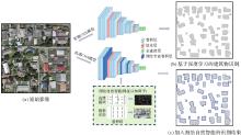
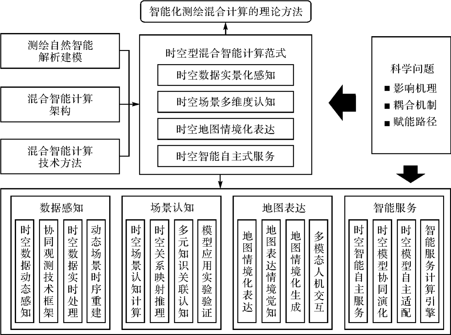
Fig.1
Image feature recognition guided by natural intelligence in surveying and mapping"

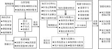
Fig.2
Core connotation of spatiotemporal hybrid computing paradigm KDAS"

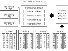
Fig.3
Key tasks of intelligentized surveying and mapping and research methods for hybrid computing"
| [1] | 王之卓. 当代测绘学科的发展[J]. 测绘学报, 1998, 27(4):283-286. |
| WANG Zhizhuo. Development of surveying and mapping[J]. Acta Geodaetica et Cartographica Sinica, 1998, 27(4):283-286. | |
| [2] | 宁津生, 王正涛. 从测绘学向地理空间信息学演变历程[J]. 测绘学报, 2017, 46(10):1213-1218.DOI:10.11947/j.AGCS.2017.20170375. |
| NING Jinsheng, WANG Zhengtao. Progresses from surveying and mapping to geomatics[J]. Acta Geodaetica et Cartographica Sinica, 2017, 46(10):1213-1218.DOI:10.11947/j.AGCS.2017.20170375. | |
| [3] | 杨凯. 建立我国数字化测绘技术体系的有关问题[M]//测绘遥感信息工程国家重点实验室年报 (1990—1991). 武汉: 武汉大学出版社, 1992. |
| YANG Kai. Issues related to establishing a digital surveying and mapping technology system in China[M]//Annual report of the State Key Laboratory of Surveying, Mapping and Remote Sensing Information Engineering (1990—1991). Wuhan: Wuhan University Press, 1992. | |
| [4] | 陈军, 刘建军, 田海波. 实景三维中国建设的基本定位与技术路径[J]. 武汉大学学报(信息科学版), 2022, 47(10):1568-1575. |
| CHEN Jun, LIU Jianjun, TIAN Haibo. Basic directions and technological path for building 3D realistic geospatial scene in China[J]. Geomatics and Information Science of Wuhan University, 2022, 47(10):1568-1575. | |
| [5] | 宁津生. 测绘科学与技术转型升级发展战略研究[J]. 武汉大学学报(信息科学版), 2019, 44(1):1-9. |
| NING Jinsheng. Research on the development strategy of surveying and mapping science and technology transformation and upgrading[J]. Geomatics and Information Science of Wuhan University, 2019, 44(1):1-9. | |
| [6] | 陈军, 刘万增, 武昊, 等. 智能化测绘的基本问题与发展方向[J]. 测绘学报, 2021, 50(8):995-1005.DOI:10.11947/j.AGCS.2021.20210235. |
| CHEN Jun, LIU Wanzeng, WU Hao, et al. Smart surveying and mapping: fundamental issues and research agenda[J]. Acta Geodaetica et Cartographica Sinica, 2021, 50(8):995-1005.DOI:10.11947/j.AGCS.2021.20210235. | |
| [7] | 高井祥, 王坚, 李增科. 智能背景下测绘科技发展的几点思考[J]. 武汉大学学报(信息科学版), 2019, 44(1):55-61. |
| GAO Jingxiang, WANG Jian, LI Zengke. Challenges for the development of surveying and mapping technology in the age of intelligence[J]. Geomatics and Information Science of Wuhan University, 2019, 44(1):55-61. | |
| [8] | 刘经南, 郭文飞, 郭迟, 等. 智能时代泛在测绘的再思考[J]. 测绘学报, 2020, 49(4):403-414.DOI:10.11947/j.AGCS.2020.20190539. |
| LIU Jingnan, GUO Wenfei, GUO Chi, et al. Rethinking ubiquitous mapping in the intelligent age[J]. Acta Geodaetica et Cartographica Sinica, 2020, 49(4):403-414.DOI:10.11947/j.AGCS.2020.20190539. | |
| [9] | 闫利, 李建成. 测绘类专业的“新工科” 建设思考[J]. 测绘通报, 2020 (12):148-154. |
| YAN Li, LI Jiancheng. The emerging engineering education construction for surveying and mapping specialty[J]. Bulletin of Surveying and Mapping, 2020 (12):148-154. | |
| [10] | 杨必胜, 陈一平, 邹勤. 从大模型看测绘时空信息智能处理的机遇和挑战[J]. 武汉大学学报(信息科学版), 2023, 48(11):1756-1768. |
| YANG Bisheng, CHEN Yiping, ZOU Qin. Opportunities and challenges of spatiotemporal information intelligent processing of surveying and mapping in the era of large models[J]. Geomatics and Information Science of Wuhan University, 2023, 48(11):1756-1768. | |
| [11] | 孙群. 专家系统以及它在地图制图领域中的应用[J]. 解放军测绘学院学报, 1992, 9(1):67-73. |
| SUN Qun. Expert system and its application in cartography[J]. Journal of the PLA Institute of Surveying and Mapping, 1992, 9(1):67-73. | |
| [12] | 华一新. 用专家系统技术确定地图要素的地图符号类型[J]. 解放军测绘学院学报, 1991, 8(3):43-47, 55. |
| HUA Yixin. Determine the map symbol type of map element with expert system technology[J]. Journal of the PLA Institute of Surveying and Mapping, 1991, 8(3):43-47, 55. | |
| [13] | 张文星, 苏波, 李华, 等. 集成式专家系统工具GEST[J]. 武汉测绘科技大学学报, 1992, 17(3):1-8. |
| ZHANG Wenxing, SU Bo, LI Hua, et al. An integrated expert system tool—GEST[J]. Journal of Wuhan Technical University of Surveying and Mapping, 1992, 17(3):1-8. | |
| [14] | SESTER M. Knowledge acquisition for the automatic interpretation of spatial data[J]. International Journal of Geographical Information Science, 2000, 14(1):1-24. |
| [15] | 艾廷华. 深度学习赋能地图制图的若干思考[J]. 测绘学报, 2021, 50(9):1170-1182.DOI:10.11947/j.AGCS.2021.20210091. |
| AI Tinghua. Some thoughts on deep learning enabling cartography[J]. Acta Geodaetica et Cartographica Sinica, 2021, 50(9):1170-1182.DOI:10.11947/j.AGCS.2021.20210091. | |
| [16] | 江南, 马健, 武丽丽, 等. 面向自动推荐的表示方法规则的形式化表达研究[J]. 测绘通报, 2015 (9):36-38, 43. |
| JIANG Nan, MA Jian, WU Lili, et al. The formalization expression of representation method rules oriented to automatic recommendation[J]. Bulletin of Surveying and Mapping, 2015 (9):36-38, 43. | |
| [17] | 丁小辉, 张树清, 陈祥葱, 等. 时空对象行为分类与形式化表达[J]. 地球信息科学学报, 2017, 19(9):1195-1200. |
| DING Xiaohui, ZHANG Shuqing, CHEN Xiangcong, et al. A study on the classification and formalization of the behavior of spatio-temporal object[J]. Journal of Geo-Information Science, 2017, 19(9):1195-1200. | |
| [18] | 王家耀. 时空大数据时代的地图学[J]. 测绘学报, 2017, 46(10):1226-1237.DOI:10.11947/j.AGCS.2017.20170308. |
| WANG Jiayao. Cartography in the age of spatio-temporal big data[J]. Acta Geodaetica et Cartographica Sinica, 2017, 46(10):1226-1237.DOI:10.11947/j.AGCS.2017.20170308. | |
| [19] | 刘经南, 高柯夫. 智能时代测绘与位置服务领域的挑战与机遇[J]. 武汉大学学报(信息科学版), 2017, 42(11):1506-1517. |
| LIU Jingnan, GAO Kefu. Challenges and opportunities for mapping and surveying and location based service in the age of intelligence[J]. Geomatics and Information Science of Wuhan University, 2017, 42(11):1506-1517. | |
| [20] | 刘经南, 罗亚荣, 郭迟, 等. PNT智能与智能PNT[J]. 测绘学报, 2022, 51(6):811-828.DOI:10.11947/j.AGCS.2022.20220152. |
| LIU Jingnan, LUO Yarong, GUO Chi, et al. PNT intelligence and intelligent PNT[J]. Acta Geodaetica et Cartographica Sinica, 2022, 51(6):811-828.DOI:10.11947/j.AGCS.2022.20220152. | |
| [21] | 杨元喜, 王建荣. 泛在感知与航天测绘[J]. 测绘学报, 2023, 52(1):1-7.DOI:10.11947/j.AGCS.2023.20220405. |
| YANG Yuanxi, WANG Jianrong. Ubiquitous perception and space mapping[J]. Acta Geodaetica et Cartographica Sinica, 2023, 52(1):1-7.DOI:10.11947/j.AGCS.2023.20220405. | |
| [22] | 朱日祥, 侯增谦, 郭正堂, 等. 宜居地球的过去、现在与未来:地球科学发展战略概要[J]. 科学通报, 2021, 66(35):4485-4490. |
| ZHU Rixiang, HOU Zengqian, GUO Zhengtang, et al. Summary of “the past, present and future of the habitable Earth: development strategy of Earth science”[J]. Chinese Science Bulletin, 2021, 66(35):4485-4490. | |
| [23] | 张广运, 张荣庭, 戴琼海, 等. 测绘地理信息与人工智能2.0融合发展的方向[J]. 测绘学报, 2021, 50(8):1096-1108.DOI:10.11947/j.AGCS.2021.20210200. |
| ZHANG Guangyun, ZHANG Rongting, DAI Qionghai, et al. The direction of integration surveying and mapping geographic information and artificial intelligence 2.0[J]. Acta Geodaetica et Cartographica Sinica, 2021, 50(8):1096-1108.DOI:10.11947/j.AGCS.2021.20210200. | |
| [24] | 郑南宁. 人工智能新时代[J]. 智能科学与技术学报, 2019, 1(1):1-3. |
| ZHENG Nanning. A new era of artificial intelligence[J]. Journal of Intelligent Science and Technology, 2019, 1(1):1-3. | |
| [25] | 吴文峻, 马宇晴, 高雅君, 等. 人工智能驱动科学研究新范式综述:模型、应用与案例[J]. 人工智能, 2023, 10(3):1-17. |
| WU Wenjun, MA Yuqing, GAO Yajun, et al. A summary of the new paradigm of artificial intelligence driving scientific research—models, applications and cases[J]. AI-View, 2023, 10(3):1-17. | |
| [26] | 骆剑承, 吴田军, 夏列钢. 遥感图谱认知理论与计算[J]. 地球信息科学学报, 2016, 18(5):578-589. |
| LUO Jiancheng, WU Tianjun, XIA Liegang. The theory and calculation of spatial-spectral cognition of remote sensing[J]. Journal of Geo-Information Science, 2016, 18(5):578-589. | |
| [27] | YAN Li, ZHU Ruixi, LIU Yi, et al. Scene capture and selected codebook-based refined fuzzy classification of large high-resolution images[J]. IEEE Transactions on Geoscience and Remote Sensing, 2018, 56(7):4178-4192. |
| [28] | 龚健雅, 季顺平. 摄影测量与深度学习[J]. 测绘学报, 2018, 47(6):693-704.DOI:10.11947/j.AGCS.2018.20170640. |
| GONG Jianya, JI Shunping. Photogrammetry and deep learning[J]. Acta Geodaetica et Cartographica Sinica, 2018, 47(6):693-704.DOI:10.11947/j.AGCS.2018.20170640. | |
| [29] | MO Nan, YAN Li, ZHU Ruixi, et al. Class-specific anchor based and context-guided multi-class object detection in high resolution remote sensing imagery with a convolutional neural network[J]. Remote Sensing, 2019, 11(3):272. |
| [30] | 王克平, 洪安东, 吴国栋. 基于知识图谱的海洋测绘发展趋势研究[J]. 天津科技, 2022, 49(1):20-24. |
| WANG Keping, HONG Andong, WU Guodong. Research on development trend of marine surveying and charting based on knowledge graph[J]. Tianjin Science & Technology, 2022, 49(1):20-24. | |
| [31] | YAN Li, HUANG Jianming, XIE Hong, et al. Efficient depth fusion transformer for aerial image semantic segmentation[J]. Remote Sensing, 2022, 14(5):1294. |
| [32] | 刘贤, 李爱国, 邬梁超. 基于知识图谱的海洋测绘发展趋势研究[J]. 低碳世界, 2023, 13(7):184-186. |
| LIU Xian, LI Aiguo, WU Liangchao. Research on the development trend of marine surveying and mapping based on knowledge map[J]. Low Carbon World, 2023, 13(7):184-186. | |
| [33] | 桂志鹏, 胡晓辉, 刘欣婕, 等. 顾及地理语义的地图检索意图形式化表达与识别[J]. 地球信息科学学报, 2023, 25(6):1186-1201. |
| GUI Zhipeng, HU Xiaohui, LIU Xinjie, et al. Map retrieval intention formalization and recognition by considering geographic semantics[J]. Journal of Geo-Information Science, 2023, 25(6):1186-1201. | |
| [34] | 闫利, 张毅, 杨见兵, 等. 自然资源典型地类遥感智能主动调查监测技术及应用[J]. 地理信息世界, 2022, 29(5):66-73. |
| YAN Li, ZHANG Yi, YANG Jianbing, et al. Autonomous remote sensing investigation and monitoring technique of typical classes of natural resources and its application[J]. Geomatics World, 2022, 29(5):66-73. | |
| [35] | WEI Pengcheng, YAN Li, XIE Hong, et al. LiDeNeRF: neural radiance field reconstruction with depth prior provided by LiDAR point cloud[J]. ISPRS Journal of Photogrammetry and Remote Sensing, 2024, 208:296-307. |
| [36] | PAN Yunhe. Heading toward artificial intelligence 2.0[J]. Engineering, 2016, 2(4):409-413. |
| [37] | BERGEN K J, JOHNSON P A, DE HOOP M V, et al. Machine learning for data-driven discovery in solid Earth geoscience[J]. Science, 2019, 363(6433):eaau0323. |
| [38] | REICHSTEIN M, CAMPS-VALLS G, STEVENS B, et al. Deep learning and process understanding for data-driven Earth system science[J]. Nature, 2019, 566(7743):195-204. |
| [39] | 龚健雅, 许越, 胡翔云, 等. 遥感影像智能解译样本库现状与研究[J]. 测绘学报, 2021, 50(8):1013-1022.DOI:10.11947/j.AGCS.2021.20210085. |
| GONG Jianya, XU Yue, HU Xiangyun, et al. Status analysis and research of sample database for intelligent interpretation of remote sensing image[J]. Acta Geodaetica et Cartographica Sinica, 2021, 50(8):1013-1022.DOI:10.11947/j.AGCS.2021.20210085. | |
| [40] | YAN Li, YANG Jianbing, ZHANG Yi, et al. Radiometric normalization for cross-sensor optical Gaofen images with change detection and Chi-square test[J]. Remote Sensing, 2021, 13(16):3125. |
| [41] | XIAO Wensheng, LI Guangxin, LIU Chao, et al. A novel chaotic and neighborhood search-based artificial bee colony algorithm for solving optimization problems[J]. Scientific Reports, 2023, 13:20496. |
| [42] | VASWANI A, SHAZEER N, PARMAR N, et al. Illia polosukhin: attention is all you need[C]//Proceedings of 2017 Annual Conference on Neural Information Processing Systems. Long Beach: IEEE, 2017: 5998-6008. |
| [43] | 鄂维南. AI助力打造科学研究新范式[J]. 中国科学院院刊, 2024, 39(1):10-16. |
| E Weinan. AI helps to establish a new paradigm for scientific research[J]. Bulletin of Chinese Academy of Sciences, 2024, 39(1):10-16. | |
| [44] | ZHU Shiqiang, YU Ting, XU Tao, et al. Intelligent computing: the latest advances, challenges, and future[J]. Intelligent Computing, 2023, 2:6. |
| [45] | 陈晨, 王艳慧, 陈军. 国际摄影测量与遥感学会 (ISPRS) 2022—2026年研究方向[J]. 地理信息世界, 2022, 29(6):98-103. |
| CHEN Chen, WANG Yanhui, CHEN Jun. Research directions of the international society for photogrammetry and remote sensing (ISPRS) for 2022—2026[J]. Geomatics World, 2022, 29(6):98-103. | |
| [46] | 陈军, 武昊, 张继贤, 等. 自然资源调查监测技术体系构建的方向与任务[J]. 地理学报, 2022, 77(5):1041-1055. |
| CHEN Jun, WU Hao, ZHANG Jixian, et al. Building natural resources surveying and monitoring technological system: direction and research agenda[J]. Acta Geographica Sinica, 2022, 77(5):1041-1055. | |
| [47] | 陈军, 王艳慧, 武昊, 等. 时空信息赋能高质量发展的基本问题与发展方向[J]. 时空信息学报, 2023 (1):1-11. |
| CHEN Jun, WANG Yanhui, WU Hao, et al. Basic issues and development directions of high-quality development empowered by spatio-temporal information[J]. Journal of Spatio-Temporal Information, 2023 (1):1-11. | |
| [48] | 杜志强, 李钰, 张叶廷, 等. 自然灾害应急知识图谱构建方法研究[J]. 武汉大学学报(信息科学版), 2020, 45(9):1344-1355. |
| DU Zhiqiang, LI Yu, ZHANG Yeting, et al. Knowledge graph construction method on natural disaster emergency[J]. Geomatics and Information Science of Wuhan University, 2020, 45(9):1344-1355. | |
| [49] | 郭仁忠, 罗婷文. 土地资源智能管控[J]. 科学通报, 2019, 64(21):2166-2171. |
| GUO Renzhong, LUO Tingwen. Intelligent management and control for land resources[J]. Chinese Science Bulletin, 2019, 64(21):2166-2171. | |
| [50] | 郭仁忠, 林浩嘉, 贺彪, 等. 面向智慧城市的GIS框架[J]. 武汉大学学报(信息科学版), 2020, 45(12):1829-1835. |
| GUO Renzhong, LIN Haojia, HE Biao, et al. GIS framework for smart cities[J]. Geomatics and Information Science of Wuhan University, 2020, 45(12):1829-1835. | |
| [51] | 刘万增, 陈军, 翟曦, 等. 时空知识中心的研究进展与应用[J]. 测绘学报, 2021, 50(9):1183-1193. |
| LIU Wanzeng, CHEN Jun, ZHAI Xi, et al. Research progress and application of spatiotemporal knowledge center[J]. Acta Geodaetica et Cartographica Sinica, 2021, 50(9):1183-1193. | |
| [52] | PIERDICCA R, PAOLANTI M. GeoAI: a review of artificial intelligence approaches for the interpretation of complex geomatics data[J]. Geoscientific Instrumentation, Methods and Data Systems, 2022, 11(1):195-218. |
| [53] | LI Zhilin. Mathematical background[M]//Algorithmic foundation of multi-scale spatial representation. Boca Raton: CRC Press, 2006: 49-76. |
| [54] | 郑南宁.“混合增强智能”是人工智能的发展趋向[N]. 人民日报, 2017-11-13(1). |
| ZHENG Nanning. “Hybrid enhanced intelligence ”is the development trend of artificial intelligence[N]. People's Daily, 2017-11-13(1). | |
| [55] | PAN Yunhe. The direction of AI: the emergence and upgrading of knowledge[C]//Proceedings of 2022 World Conference on Artificial Intelligence Scientific Frontiers Plenary Session. Shanghai: Springer, 2022. |
| [56] | SCARSELLI F, GORI M, TSOI A C, et al. The graph neural network model[J]. IEEE Transactions on Neural Networks, 2009, 20(1):61-80. |
| [57] | LECUN Y, BENGIO Y, HINTON G. Deep learning[J]. Nature, 2015, 521:436-444. |
| [58] | 王俞涵, 陈子阳, 赵翔, 等. 时序知识图谱表示与推理的研究进展与趋势[J/OL]. 软件学报: 1-29 [2024-02-11].https://doi.org/10.13328/j.cnki.jos.007093. |
| WANG Yuhan, CHEN Ziyang, ZHAO Xiang, et al. Survey on temporal knowledge graph representation and reasoning[J/OL]. Journal of Software: 1-29 [2024-02-11].https://doi.org/10.13328/j.cnki.jos.007093. | |
| [59] | 李铭, 朱欣焰, 段炼, 等. 时空约束下任务驱动的遥感影像发现案例推理方法[J]. 武汉大学学报(信息科学版), 2017, 42(6):768-774. |
| LI Ming, ZHU Xinyan, DUAN Lian, et al. A case-based reasoning approach for task-driven remote sensing image discovery under spatial-temporal constrains[J]. Geomatics and Information Science of Wuhan University, 2017, 42(6):768-774. | |
| [60] | 张祖勋, 林宗坚. 摄影测量测图的全数字化道路[J]. 武汉测绘学院学报, 1985 (3):13-18. |
| ZHANG Zuxun, LIN Zongjian. The full digital path of photogrammetric mapping [J]. Journal of Wuhan Institute of Surveying and Mapping, 1985 (3):13-18. | |
| [61] | 潘正风. 大比例尺数字测图[M]. 北京: 测绘出版社, 1996. |
| PAN Zhengfeng. Large scale digital mapping[M]. Beijing: Surveying and Mapping Press, 1996. | |
| [62] | 杜清运. 空间信息的结构、表达及其理解机制[J]. 武汉测绘科技大学学报, 1998 (4):388-393. |
| DU Qingyun. Structure, representation and understanding of spatial information[J]. Geomatics and Information Science of Wuhan University, 1998 (4):388-393. | |
| [63] | 刘瑜, 郭浩, 李海峰, 等. 从地理规律到地理空间人工智能[J]. 测绘学报, 2022, 51(6):1062-1069.DOI:10.11947/j.AGCS.2022.20220125. |
| LIU Yu, GUO Hao, LI Haifeng, et al. A note on GeoAI from the perspective of geographical laws[J]. Acta Geodaetica et Cartographica Sinica, 2022, 51(6):1062-1069.DOI:10.11947/j.AGCS.2022.20220125. | |
| [64] | 安沈昊, 于荣欢. 复杂网络理论研究综述[J]. 计算机系统应用, 2020, 29(9):26-31. |
| AN Shenhao, YU Ronghuan. Review on complex network theory research[J]. Computer Systems & Applications, 2020, 29(9):26-31. | |
| [65] | 张兵. 遥感大数据时代与智能信息提取[J]. 武汉大学学报(信息科学版), 2018, 43(12):1861-1871. |
| ZHANG Bing. Remotely sensed big data era and intelligent information extraction[J]. Geomatics and Information Science of Wuhan University, 2018, 43(12):1861-1871. | |
| [66] | 刘华峰, 陈静静, 李亮, 等. 跨模态表征与生成技术[J]. 中国图象图形学报, 2023, 28(6):1608-1629. |
| LIU Huafeng, CHEN Jingjing, LI Liang, et al. Cross-modal representation learning and generation[J]. Journal of Image and Graphics, 2023, 28(6):1608-1629. | |
| [67] | 朱建军, 宋迎春, 胡俊, 等. 测绘大数据时代数据处理理论面临的挑战与发展[J]. 武汉大学学报(信息科学版), 2021, 46(7):1025-1031. |
| ZHU Jianjun, SONG Yingchun, HU Jun, et al. Challenges and development of data processing theory in the era of surveying and mapping big data[J]. Geomatics and Information Science of Wuhan University, 2021, 46(7):1025-1031. | |
| [68] | 徐红. 陈军:智能化测绘,从数据信息服务走向知识服务[J]. 中国测绘, 2023 (12):12-16. |
| XU Hong. CHEN Jun: intelligent surveying and mapping, from data information service to knowledge service[J]. China Surveying and Mapping, 2023 (12):12-16. | |
| [69] | BROWN T, MANN B, RYDER N, et al. Language models are few-shot learners[J]. Advances in neural information processing systems, 2020, 33:1877-1901. |
| [70] | 姜三, 江万寿. Delaunay三角网约束下的影像稳健匹配方法[J]. 测绘学报, 2020, 49(3):322-333. |
| JIANG San, JIANG Wanshou. Robust image matching constrained by delaunay triangulation[J]. Acta Geodaetica et Cartographica Sinica, 2020, 49(3):322-333. | |
| [71] | 刘涵宇, 李威, 韩桂军, 等. 基于时空四维多尺度分析方法的卫星遥感和现场观测联合同化研究[J]. 海洋学报, 2023, 45(7):110-125. |
| LIU Hanyu, LI Wei, HAN Guijun, et al. Assimilation of combining satellite remote sensing and in situ observation based on space-time four-dimensional multi-scale analysis method[J]. Haiyang Xuebao, 2023, 45(7):110-125. | |
| [72] | 杨恒, 张文清. 多源数据融合实景三维重建研究进展[J]. 智能建筑与智慧城市, 2023 (9):70-73. |
| YANG Heng, ZHANG Wenqing. Research progress of real scene 3D reconstruction of multi-source data fusion[J]. Intelligent Building & Smart City, 2023 (9):70-73. | |
| [73] | 邢立宁, 陈英武. 基于知识的智能优化引导方法研究进展[J]. 自动化学报, 2011, 37(11):1285-1289. |
| XING Lining, CHEN Yingwu. Research progress on intelligent optimization guidance approaches using knowledge[J]. Acta Automatica Sinica, 2011, 37(11):1285-1289. | |
| [74] | 吴飞, 阳春华, 兰旭光, 等. 人工智能的回顾与展望[J]. 中国科学基金, 2018, 32(3):243-250. |
| WU Fei, YANG Chunhua, LAN Xuguang, et al. Artificial intelligence: review and future opportunities[J]. Bulletin of National Natural Science Foundation of China, 2018, 32(3):243-250. | |
| [75] | 钟义信. 人工智能:概念·方法·机遇[J]. 科学通报, 2017, 62(22):2473-2479. |
| ZHONG Yixin. Artificial intelligence: concepts, methods, and opportunities [J]. Science Bulletin, 2017, 62(22):2473-2479. | |
| [76] | HARIRI S, KHARGHARIA B, CHEN Houping, et al. The autonomic computing paradigm[J]. Cluster Computing, 2006, 9(1):5-17. |
| [77] | VÉGH J, TISAN A. The need for modern computing paradigm: science applied to computing[C]//Proceedings of 2019 International Conference on Computational Science and Computational Intelligence. Wuhan: IEEE, 2019: 1523-1532. |
| [78] | YANG L T, GUO M. High-performance computing: paradigm and infrastructure[M]. New York: John Wiley & Sons, 2005. |
| [79] | RAZAVI S. Deep learning, explained: fundamentals, explainability, and bridgeability to process-based modelling[J]. Environmental Modelling & Software, 2021, 144:105159. |
| [80] | CHEN Min, QIAN Zhen, BOERS N, et al. Iterative integration of deep learning in hybrid Earth surface system modelling[J]. Nature Reviews Earth & Environment, 2023, 4:568-581. |
| [81] | SHEN Huanfeng, ZHANG Liangpei. Mechanism-learning coupling paradigms for parameter inversion and simulation in earth surface systems[J]. Science China Earth Sciences, 2023, 66(3):568-582. |
| [82] | LI Xin, LIU Feng, FANG Miao. Harmonizing models and observations: data assimilation in Earth system science[J]. Science China Earth Sciences, 2020, 63(8):1059-1068. |
| [83] | LI Xin, MA Hanqing, RAN Youhua, et al. Terrestrial carbon cycle model-data fusion: progress and challenges[J]. Science China Earth Sciences, 2021, 64(10):1645-1657. |
| [84] | SHEN Y, SONG K, TAN X, et al. Hugging GPT: solving AI tasks with chatGPT and its friends in hugging face[EB/OL]. [2024-01-30]. https://doi.org/10.48550/arXiv.2303.17580. |
| [85] | CHAKRABORTY S, RAY B. On multi-modal learning of editing source code[C]//Proceedings of the 36th IEEE/ACM International Conference on Automated Software Engineering. Melbourne: IEEE, 2021: 443-455. |
| [86] | FLORIDI L, CHIRIATTI M. GPT-3: its nature, scope, limits, and consequences[J]. Minds and Machines, 2020, 30(4):681-694. |
| [1] | REN Jiaxin, LIU Wanzeng, CHEN Jun, ZHANG Lan, TAO Yuan, ZHU Xiuli, ZHAO Tingting, LI Ran, ZHAI Xi, WANG Haiqing, ZHOU Xiaoguang, HOU Dongyang, WANG Yong. Knowledge-guided intelligent recognition of the scale for fragmented raster topographic maps [J]. Acta Geodaetica et Cartographica Sinica, 2024, 53(1): 146-157. |
| Viewed | ||||||
|
Full text |
|
|||||
|
Abstract |
|
|||||