

Acta Geodaetica et Cartographica Sinica ›› 2025, Vol. 54 ›› Issue (5): 819-830.doi: 10.11947/j.AGCS.2025.20240449
• Geodesy and Navigation • Previous Articles Next Articles
Mingtao ZHU1( ), Yi ZHANG2, Xian MA3, Linsong WANG1,4()
Received:2024-11-01
Revised:2025-03-20
Online:2025-06-23
Published:2025-06-23
Contact:
Linsong WANG
E-mail:zhumingtao@cug.edu.cn;wanglinsong@cug.edu.cn
About author:ZHU Mingtao (2000—), male, PhD candidate, majors in ground precision gravity measurement and its application in geology. E-mail: zhumingtao@cug.edu.cn
Supported by:CLC Number:
Mingtao ZHU, Yi ZHANG, Xian MA, Linsong WANG. Simulation and verification of regional hydrological gravity effect considering undulating terrain: a case study of the head region of Three Gorges Reservoir[J]. Acta Geodaetica et Cartographica Sinica, 2025, 54(5): 819-830.
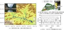
Fig. 1
Overview of the study area"

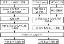
Fig. 2
Flowchart of reservoir water storage and regional hydrological load model construction"

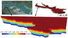
Fig. 3
Triangulation of the water storage load model in the head region of Three Gorges Reservoir (part in front of the dam)"
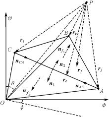
Fig. 4
A tetrahedron ABCO in the cartesian coordinate"

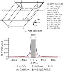
Fig. 5
Forward simulation of reservoir water storage load model"
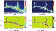
Fig. 6
The spatial distribution of gravity/gravity gradient effect caused by water storage at 145~175 m in the head region of Three Gorges Reservoir"

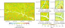
Fig. 7
Gravity effect caused by GLDAS equivalent water height difference in summer and winter in the reservoir head area from January 2010 to December 2023"

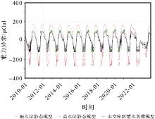
Fig. 8
Time series of gravity effect generated by different load models at 124 observation points"
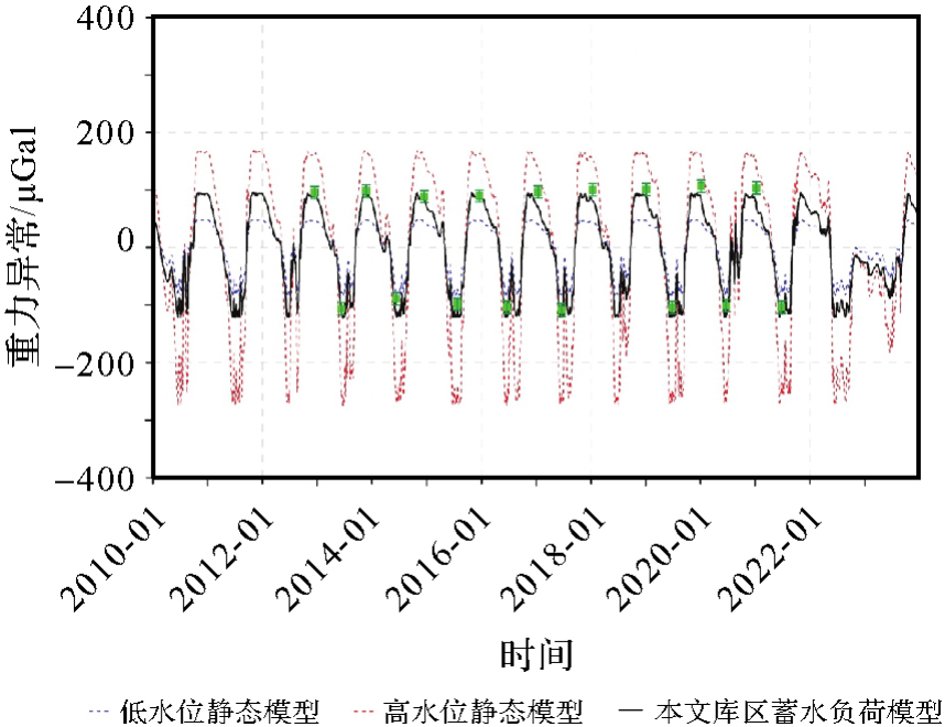
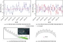
Fig. 9
The time series of regional hydrological gravitational effect and the location of water load variation at the local measuring point"

Tab. 1
Comparison of A10 absolute gravity observation and simulation results of different reservoir storage load model"
| A10测点 | 实测差异 | 低水位静态模型+区域水文模型 | 高水位静态模型+区域水文模型 | 本文蓄水模型+区域水文模型 | 区域水文模型 |
|---|---|---|---|---|---|
| 秭归测站 | 13.79 | 4.80(-8.99) | 16.85(+3.06) | 12.06(-1.74) | -3.90 |
| 112 | 64.56 | 64.57(+0.01) | 112.09(+47.52) | 76.05(+11.49) | -1.37 |
| 114 | 15.44 | 6.17(-9.27) | 65.18(+49.74) | 10.82(-4.62) | -2.36 |
| 116 | 125.18 | 13.60(-111.58) | 15.65(-109.54) | 134.02(+8.84) | -1.68 |
| 118 | 95.65 | 106.23(+10.58) | 139.45(+43.80) | 88.51(-7.15) | -1.71 |
| 120 | 137.48 | 149.42(+11.94) | 773.84(+636.35) | 102.76(-34.72) | -1.22 |
| 124 | 190.52 | 115.61(-74.91) | 388.34(+197.82) | 185.69(-4.83) | -1.00 |
| 132 | 105.55 | 71.22(-34.33) | 88.71(-16.84) | 102.52(-3.03) | -1.41 |
| 134 | 97.58 | 57.88(-39.69) | 89.91(-7.67) | 74.4(-23.17) | -1.96 |
| 138 | 284.78 | 222.91(-61.87) | 441.27(+156.49) | 307.71(+22.93) | -0.72 |
| 212 | 12.38 | 7.90(-4.49) | 11.06(-1.32) | 12.03(-0.35) | -1.99 |
| 218 | 132.61 | 67.53(-65.09) | 668.57(+535.96) | 133.54(+0.93) | -0.94 |
| 220 | 67.36 | 27.76(-39.6) | 51.15(-16.21) | 52.01(-15.34) | -0.59 |
| 222 | 73.32 | 1.08(-72.25) | 67.59(-5.73) | 38.99(-34.34) | -1.32 |
| 301 | 10.50 | 13.86(+3.36) | 27.15(+16.65) | 26.06(+15.56) | -2.04 |
| 303 | 6.18 | 0.16(-6.02) | 0.24(-5.94) | 5.43(-0.75) | -0.02 |
| 305 | 2.35 | 0.52(-1.82) | 46.41(+44.06) | 2.13(-0.21) | -2.19 |
| 306 | 1.97 | -0.63(-2.6) | 0.16(-1.81) | 0.71(-1.26) | -2.23 |
| 2222 | 22.66 | 70.28(+47.63) | 366.51(+343.85) | 47.1(+24.45) | -1.32 |
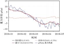
Fig. 10
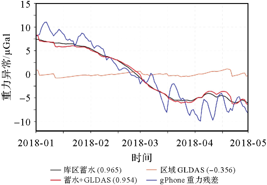
Comparison of gPhone gravity residual time series with simulation results of hydrological gravity effect"
| [1] | ZHENG Yuhao, WANG Linsong, CHEN Chao, et al. Using satellite gravity and hydrological data to estimate changes in evapotranspiration induced by water storage fluctuations in the Three Gorges Reservoir of China[J]. Remote Sensing, 2020, 12(13): 2143. |
| [2] | LI Linxuan, LUO Gang. What causes the spatiotemporal patterns of seismicity in the Three Gorges Reservoir area, central China?[J]. Earth and Planetary Science Letters, 2022, 592: 117618. |
| [3] | 孙和平, 孙文科, 申文斌, 等. 地球重力场及其地学应用研究进展:2020中国地球科学联合学术年会专题综述[J]. 地球科学进展, 2021, 36(5): 445-460. |
| SUN Heping, SUN Wenke, SHEN Wenbin, et al. Research progress of Earth's gravity field and its application in geosciences: a summary of annual meeting of Chinese geoscience union in 2020[J]. Advances in Earth Science, 2021, 36(5): 445-460. | |
| [4] | 党亚民, 王伟, 章传银, 等. 综合GNSS和重力数据定量评价三峡地区地质环境稳定性[J]. 武汉大学学报(信息科学版), 2020, 45(7): 1052-1057. |
| DANG Yamin, WANG Wei, ZHANG Chuanyin, et al. Quantitative evaluation of geological environment stability in the Three Gorges area with continuous GNSS and gravity data[J]. Geomatics and Information Science of Wuhan University, 2020, 45(7): 1052-1057. | |
| [5] | SUN Heping, BAO Lifeng, CHEN Shi, et al. Research progress in surface and marine gravimetry[J]. Journal of Geodesy and Geoinformation Science, 2023, 6(3): 19-32. |
| [6] | FENG Wei, XIONG Yuhao, YI Shuang, et al. Recent progress on hydrogeodesy in China[J]. Journal of Geodesy and Geoinformation Science, 2023, 6(3): 124-134. |
| [7] | WANG Hansheng. Surface vertical displacements and level plane changes in the front reservoir area caused by filling the Three Gorges Reservoir[J]. Journal of Geophysical Research: Solid Earth, 2000, 105(B6): 13211-13220. |
| [8] | WANG H, HSU H T, ZHU Y Z. Prediction of surface horizontal displacements, and gravity and tilt changes caused by filling the Three Gorges Reservoir[J]. Journal of Geodesy, 2002, 76(2): 105-114. |
| [9] | BOY J, CHAO B F. Time-variable gravity signal during the water impoundment of China's Three-Gorges Reservoir[J]. Geophysical Research Letters, 2002, 29(24): 53-1-53-4. |
| [10] | 杨光亮, 申重阳, 王晓权, 等. 三峡水库蓄水重力效应数值模拟[J]. 大地测量与地球动力学, 2005, 25(1): 19-23. |
| YANG Guangliang, SHEN Chongyang, WANG Xiaoquan, et al. Numerical simulation of gravity effect of water-impoundment in Three Gorges Reservoir[J]. Journal of Geodesy and Geodynamics, 2005, 25(1): 19-23. | |
| [11] |
王林松, 陈超, 马险, 等. 基于SRTM-DEM数据的三峡库区蓄水负荷模型及其地表重力与形变响应模拟[J]. 测绘学报, 2016, 45(10): 1148-1156. DOI: .
doi: 10.11947/j.AGCS.2016.20160016 |
|
WANG Linsong, CHEN Chao, MA Xian, et al. A water storage loading model by SRTM-DEM data and surface response simulation of gravity and deformation in the Three Gorges Reservoir of China[J]. Acta Geodaetica et Cartographica Sinica, 2016, 45(10): 1148-1156. DOI: .
doi: 10.11947/j.AGCS.2016.20160016 |
|
| [12] | 王伟, 党亚民, 章传银, 等. 基于CORS站网监测三峡地区陆地水负荷对地壳形变和重力变化的影响[J]. 地球物理学报, 2017, 60(3): 962-971. |
| WANG Wei, DANG Yamin, ZHANG Chuanyin, et al. Monitoring of crustal deformation and gravity variation from terrestrial water loading in the Three Gorges region by the CORS network[J]. Chinese Journal of Geophysics, 2017, 60(3): 962-971. | |
| [13] | 章传银, 王伟, 甘卫军, 等. 利用CORS站网监测三峡地区环境负荷引起的地壳形变与重力场时空变化[J]. 武汉大学学报(信息科学版), 2018, 43(9): 1287-1294. |
| ZHANG Chuanyin, WANG Wei, GAN Weijun, et al. Monitoring temporal and spatial changes of crustal deformation and gravity field caused by environmental load in the Three Gorges Reservoir region based on CORS network[J]. Geomatics and Information Science of Wuhan University, 2018, 43(9): 1287-1294. | |
| [14] | MA Xian, WANG Linsong, CHEN Chao, et al. Simulation of the dynamic water storage and its gravitational effect in the head region of Three Gorges Reservoir using imageries of Gaofen-1[J]. Remote Sensing, 2020, 12(20): 3353. |
| [15] | WANG Xianwei, CHEN Yan, SONG Lianchun, et al. Analysis of lengths, water areas and volumes of the Three Gorges Reservoir at different water levels using Landsat images and SRTM DEM data[J]. Quaternary International, 2013, 304: 115-125. |
| [16] | DU Wenying, CHEN Nengcheng, LIU Dandan. Automatic balloon snake method for topology adaptive water boundary extraction: using GF-1 satellite imagery as an example[J]. IEEE Journal of Selected Topics in Applied Earth Observations and Remote Sensing, 2017, 10(12): 5381-5394. |
| [17] | ZHU Siyu, WAN Wei, XIE Hongjie, et al. An efficient and effective approach for georeferencing AVHRR and GaoFen-1 imageries using inland water bodies[J]. IEEE Journal of Selected Topics in Applied Earth Observations and Remote Sensing, 2018, 11(7): 2491-2500. |
| [18] | RABUS B, EINEDER M, ROTH A, et al. The shuttle radar topography mission: a new class of digital elevation models acquired by spaceborne radar[J]. ISPRS Journal of Photogrammetry and Remote Sensing, 2003, 57(4): 241-262. |
| [19] | 马险. 三峡库区高精度库水模型构建及其重力效应研究[D]. 武汉: 中国地质大学, 2021. |
| MA Xian. Construction of high-resolution water storage model and its gravitational effect in Three Gorges Reservoir area[D]. Wuhan: China University of Geosciences, 2021. | |
| [20] | RODELL M, HOUSER P R, JAMBOR U, et al. The global land data assimilation system[J]. Bulletin of the American Meteorological Society, 2004, 85(3): 381-394. |
| [21] | LAWSON C L. Properties of n-dimensional triangulations[J]. Computer Aided Geometric Design, 1986, 3(4): 231-246. |
| [22] | 高新宇, 鲁宝亮, 安国强, 等. 起伏地形下基于非结构网格模型降维的重力三维密度反演[J]. 地球物理学报, 2024, 67(1): 379-393. |
| GAO Xinyu, LU Baoliang, AN Guoqiang, et al. 3D density inversion of gravity based on unstructured grid and model dimension reduction under undulating terrain[J]. Chinese Journal of Geophysics, 2024, 67(1): 379-393. | |
| [23] | WERNER R A, SCHEERES D J. Exterior gravitation of a polyhedron derived and compared with harmonic and mascon gravitation representations of asteroid 4769 Castalia[J]. Celestial Mechanics and Dynamical Astronomy, 1996, 65: 313-344. |
| [24] | ZHANG Yi, CHEN Chao. Forward calculation of gravity and its gradient using polyhedral representation of density interfaces: an application of spherical or ellipsoidal topographic gravity effect[J]. Journal of Geodesy, 2018, 92: 205-218. |
| [25] | CHEN K H, HWANG C, CHANG L C, et al. Measuring aquifer specific yields with absolute gravimetry: result in the Choushui river alluvial fan and Mingchu basin, central Taiwan[J]. Water Resources Research, 2020, 56(9): e2020WR027261. |
| [26] | CREUTZFELDT B, GÜNTNER A, KLÜGEL T, et al. Simulating the influence of water storage changes on the superconducting gravimeter of the Geodetic Observatory Wettzell, Germany[J]. Geophysics, 2008, 73(6): WA95-WA104. |
| [27] | WANG Linsong, PENG Zhenran, MA Xian, et al. Multiscale gravity measurements to characterize 2020 flood events and their spatio-temporal evolution in Yangtze river of China[J]. Journal of Hydrology, 2021, 603: 127176. |
| [28] | 马险, 王林松, 陈超, 等. 利用gPhone重力仪监测三峡库区蓄水的重力响应[J]. 大地测量与地球动力学, 2017, 37(4): 420-424. |
| MA Xian, WANG Linsong, CHEN Chao, et al. Detecting the gravimetric response of impound in the Three Gorges Reservoir area using gPhone gravimeter in Zigui[J]. Journal of Geodesy and Geodynamics, 2017, 37(4): 420-424. | |
| [29] | 李晖, 刘子维, 江颖, 等. 三峡库首区蓄放水重力效应模型的构建与观测[J]. 大地测量与地球动力学, 2024, 44(8): 867-872. |
| LI Hui, LIU Ziwei, JIANG Ying, et al. Construction and observation of gravity effect model of water storage and release in the head area of the Three Gorges Reservoir[J]. Journal of Geodesy and Geodynamics, 2024, 44(8): 867-872. | |
| [30] | VAN CAMP M, VAUTERIN P. Tsoft: graphical and interactive software for the analysis of time series and Earth tides[J]. Computers & Geosciences, 2005, 31(5): 631-640. |
| [1] | XIAO Tianyuan, AI Tinghua, YU Huafei, YANG Min, LIU Pengcheng. A point cluster simplification approach of graph convolutional neural network for map generalization [J]. Acta Geodaetica et Cartographica Sinica, 2024, 53(1): 158-172. |
| [2] | WEI Hongcheng, ZHANG Lihua, TANG Lulu, DONG Jian, LI Gaixiao, YUAN Hao. Complexity measurement of line element on nautical chart considering local difference [J]. Acta Geodaetica et Cartographica Sinica, 2022, 51(9): 1959-1968. |
| [3] | LI Yang, GUO Jinyun, SUN Yu, YUAN Jiajia, CHANG Xiaotao, ZHANG Hongri. Inversion of global sea level change and its component contributions by combining time-varying gravity data and altimetry data [J]. Acta Geodaetica et Cartographica Sinica, 2022, 51(8): 1768-1778. |
| [4] | JIANG San, JIANG Wanshou. Robust image matching constrained by delaunay triangulation [J]. Acta Geodaetica et Cartographica Sinica, 2020, 49(3): 322-333. |
| [5] | YAN Jinbiao, WU Bo, PENG Xin. A method to shape reconstruction from planar point sets with Gestalt proximity and simplification principle [J]. Acta Geodaetica et Cartographica Sinica, 2020, 49(11): 1485-1496. |
| [6] | LI Chengming, YIN Yong, WU Pengda, LIU Xiaoli. An automatic recognition and processing method for agglomeration area in aggregated area groups [J]. Acta Geodaetica et Cartographica Sinica, 2019, 48(3): 363-373. |
| [7] | LIU Wenkai, LIU Qiliang, CAI Jiannan. Discovery of co-location patterns based on natural neighborhood [J]. Acta Geodaetica et Cartographica Sinica, 2019, 48(1): 95-105. |
| [8] | JIA Junhui, HUANG Ming, LIU Xianglei. Surface Reconstruction Algorithm Based on 3D Delaunay Triangulation [J]. Acta Geodaetica et Cartographica Sinica, 2018, 47(2): 281-290. |
| [9] | YANG Wei, AI Tinghua. A Method for Road Map Construction Based on Trajectory Segmentation and Layer Fusion Using Vehicle Track Line [J]. Acta Geodaetica et Cartographica Sinica, 2018, 47(12): 1650-1659. |
| [10] | ZHU Jie, SUN Yizhong. An Efficient Approach to Shape Reconstruction from Planar Point Set Based on Multi-constraints [J]. Acta Geodaetica et Cartographica Sinica, 2017, 46(2): 253-264. |
| [11] | YANG Wei, AI Tinghua. The Extraction of Road Boundary from Crowdsourcing Trajectory Using Constrained Delaunay Triangulation [J]. Acta Geodaetica et Cartographica Sinica, 2017, 46(2): 237-245. |
| [12] | GUO Peipei, LI Chengming, YIN Yong. Classification and Filtering of Constrained Delaunay Triangulation for Automated Building Aggregation [J]. Acta Geodaetica et Cartographica Sinica, 2016, 45(8): 1001-1007. |
| [13] | HAN Yuanli. A General-division Grid Pattern Delaunay-TIN Parallel Algorithm [J]. Acta Geodaetica et Cartographica Sinica, 2015, 44(6): 702-708. |
| [14] | . A Method of Road Network Generalization Considering Stroke Properties of Road Object [J]. Acta Geodaetica et Cartographica Sinica, 2013, 42(4): 0-0. |
| [15] | . Geographic-feature Oriented Ria Coastline Simplification [J]. Acta Geodaetica et Cartographica Sinica, 2013, 42(4): 0-0. |
| Viewed | ||||||
|
Full text |
|
|||||
|
Abstract |
|
|||||