

Acta Geodaetica et Cartographica Sinica ›› 2025, Vol. 54 ›› Issue (12): 2262-2275.doi: 10.11947/j.AGCS.2025.20250162
• Cartography and Geoinformation • Previous Articles Next Articles
Yue QIU( ), Fang WU(), Renjian ZHAI, Haizhong QIAN, Zhekun HUANG, Bo LI
Received:2025-04-16
Revised:2025-11-01
Online:2026-01-15
Published:2026-01-15
Contact:
Fang WU
E-mail:qiuyue@whu.edu.cn;wufang_630@126.com
About author:QIU Yue (1997—), male, PhD candidate, majors in intelligent geospatial data processing. E-mail: qiuyue@whu.edu.cn
Supported by:CLC Number:
Yue QIU, Fang WU, Renjian ZHAI, Haizhong QIAN, Zhekun HUANG, Bo LI. An entity-level conformal spatial alignment model for multi-source building matching optimization[J]. Acta Geodaetica et Cartographica Sinica, 2025, 54(12): 2262-2275.
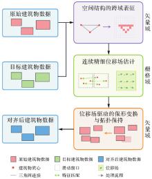
Fig. 1
The entity-level conformal spatial alignment framework using vector-raster-vector collaboration"
Fig. 2
Centroid-based spatial structure modeling and cross-domain mapping"
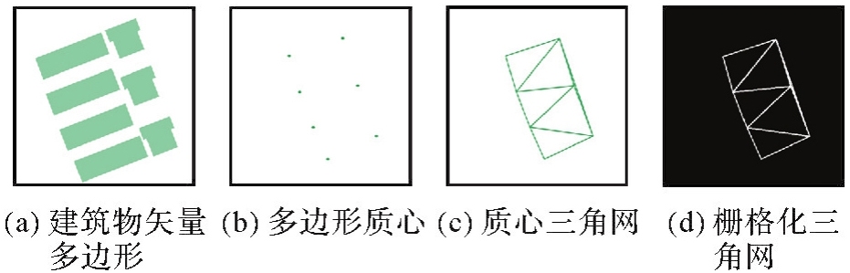
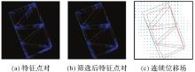
Fig. 3
Feature matching and displacement field modeling"
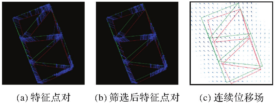
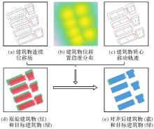
Fig. 4
Conformal rigid translation"

Tab. 1
Evaluation metrics for spatial alignment in the raster domain"
| 指标 | 定义 | 参数 | 说明 |
|---|---|---|---|
| 互信息(MI) | MI(A,B)=H(A)+H(B)-H(A,B) | H(•)为信息熵,A、B为标准化后的栅格图像 | 度量信息共享程度,值越大表明分布协同性越强 |
| 均方误差(MSE) | 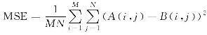 | M、N为图像尺寸 | 直接反映像素级差异,值越小表明对齐精度越高 |
| 峰值信噪比(PSNR) | 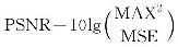 | MAX为图像最大值 | 对数尺度敏感度指标,值越大表明对齐质量越高 |
| 结构相似性指数(SSIM) | 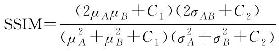 | μ为均值,σ为方差,C1、C2均为稳定性常数 | 综合亮度、对比度、结构相似性,越接近1越好 |
| 归一化互相关(NCC) | 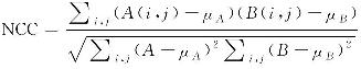 | μA、μB均为图像均值 | 衡量线性相关性,值越接近1表明分布模式越相似 |
| Dice系数 | 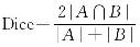 |  | 量化空间重叠度,值越接近1表明重叠区域越大 |
Tab. 2
Metrics for matching effectiveness evaluation"
| 指标 | 定义 | 参数 | 说明 |
|---|---|---|---|
| 查准率(Precision) |  | TP:真正例 FP:假正例 | 度量匹配准确性,值越大误匹配越少 |
| 查全率(Recall) |  | FN:假负例 | 度量匹配完整性,值越大漏匹配越少 |
| F1值(F1score) |  | Precision:查准率 Recall:查全率 | 综合准确性与完整性,值越大匹配性能越优 |
Tab. 3
Quantitative evaluation results of the entity-level conformal spatial alignment method"
| 指标 | 对齐前 | 对齐后 | 相对提升量/(%) | 绝对提升量 |
|---|---|---|---|---|
| MSE | 0.149 9 | 0.116 7 | 22.15 | 0.033 2 |
| NCC | 0.545 9 | 0.647 6 | 18.63 | 0.101 7 |
| PSNR | 8.240 9 | 9.327 9 | 13.19 | 1.087 0 |
| MI | 0.184 6 | 0.261 3 | 41.55 | 0.076 7 |
| SSIM | 0.779 3 | 0.816 0 | 4.71 | 0.036 7 |
| DICE | 0.640 5 | 0.721 2 | 12.60 | 0.080 7 |
| Hausdorff | 100.121 4 | 88.763 0 | 11.34 | 11.358 4 |
| 平均Hausdorff | 8.660 2 | 7.081 6 | 18.23 | 1.578 6 |
Tab. 4
Performance comparison of different spatial alignment methods"
| 指标 | 对齐前 | 本文方法 | 人工标记1对 | 人工标记5对 | 人工标记9对 | ||||
|---|---|---|---|---|---|---|---|---|---|
| 对齐后 | 相对提升量/(%) | 对齐后 | 相对提升量/(%) | 对齐后 | 相对提升量/(%) | 对齐后 | 相对提升量/(%) | ||
| MSE | 0.149 9 | 0.116 7 | 22.15 | 0.151 0 | -0.73 | 0.141 3 | 5.74 | 0.136 4 | 9.01 |
| NCC | 0.545 9 | 0.647 6 | 18.63 | 0.542 9 | -0.55 | 0.574 0 | 5.15 | 0.588 4 | 7.79 |
| PSNR | 8.240 9 | 9.327 9 | 13.19 | 8.210 8 | -0.37 | 8.498 9 | 3.13 | 8.652 0 | 4.99 |
| MI | 0.184 6 | 0.261 3 | 41.55 | 0.182 5 | -1.14 | 0.204 6 | 10.83 | 0.214 9 | 16.41 |
| SSIM | 0.779 3 | 0.816 0 | 4.71 | 0.778 4 | -0.12 | 0.788 8 | 1.22 | 0.793 8 | 1.86 |
| DICE | 0.640 5 | 0.721 2 | 12.60 | 0.638 1 | -0.37 | 0.663 3 | 3.56 | 0.674 5 | 5.31 |
| Hausdorff | 100.121 4 | 88.763 0 | 11.34 | 88.206 1 | 11.90 | 87.080 3 | 13.03 | 87.080 3 | 13.03 |
| 平均Hausdorff | 8.660 2 | 7.081 6 | 18.23 | 8.415 0 | 2.83 | 8.505 4 | 1.79 | 7.990 5 | 7.73 |
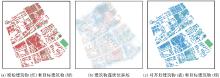
Fig. 5
Qualitative visualization of alignment results in the study area"

Tab. 5
Comparison of matching performance before and after conformal spatial alignment"
| 匹配方法 | 对齐前 | 对齐后 | 绝对提升量 | ||||||
|---|---|---|---|---|---|---|---|---|---|
| 查准率 | 查全率 | F1值 | 查准率 | 查全率 | F1值 | 查准率 | 查全率 | F1值 | |
| 位置法 | 60.29 | 76.46 | 67.42 | 66.72 | 81.93 | 73.55 | 6.43 | 5.47 | 6.13 |
| 重叠法 | 71.74 | 83.39 | 77.13 | 79.83 | 88.14 | 83.78 | 8.09 | 4.75 | 6.65 |
| 3指标法 | 77.44 | 89.60 | 83.08 | 79.23 | 89.78 | 84.17 | 1.79 | 0.18 | 1.09 |
| 6指标法 | 64.74 | 79.74 | 71.46 | 71.60 | 85.58 | 77.97 | 6.86 | 5.84 | 6.51 |
Tab. 6
Comparison of performance improvements achieved by different spatial alignment methods"
| 匹配方法 | 查准率绝对提升量 | 查全率绝对提升量 | F1值绝对提升量 | |||||||||
|---|---|---|---|---|---|---|---|---|---|---|---|---|
| 人工-1 | 人工-5 | 人工-9 | 本文方法 | 人工-1 | 人工-5 | 人工-9 | 本文方法 | 人工-1 | 人工-5 | 人工-9 | 本文方法 | |
| 位置法 | -8.02 | -2.69 | 2.37 | 6.43 | -7.12 | -1.10 | 1.64 | 5.47 | -7.81 | -2.12 | 2.12 | 6.13 |
| 重叠法 | -7.93 | 2.11 | 2.78 | 8.09 | -4.56 | 4.20 | 2.01 | 4.75 | -6.60 | 3.00 | 2.46 | 6.65 |
| 3指标法 | -0.22 | 0.50 | 0.30 | 1.79 | -2.37 | -1.28 | -1.64 | 0.18 | -1.16 | -0.27 | -0.55 | 1.09 |
| 6指标法 | -6.72 | 4.39 | 3.80 | 6.86 | -5.83 | 4.02 | 2.56 | 5.84 | -6.45 | 4.28 | 3.33 | 6.51 |
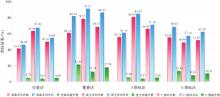
Fig. 6
Effectiveness of spatial alignment in enhancing matching performance in dense areas"

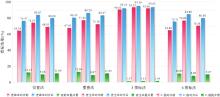
Fig. 7
Changes in matching performance before and after spatial alignment in sparse areas"

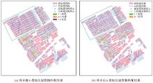
Fig. 8
Comparison of building matching results using the six-index method before and after spatial alignment"

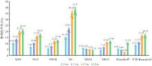
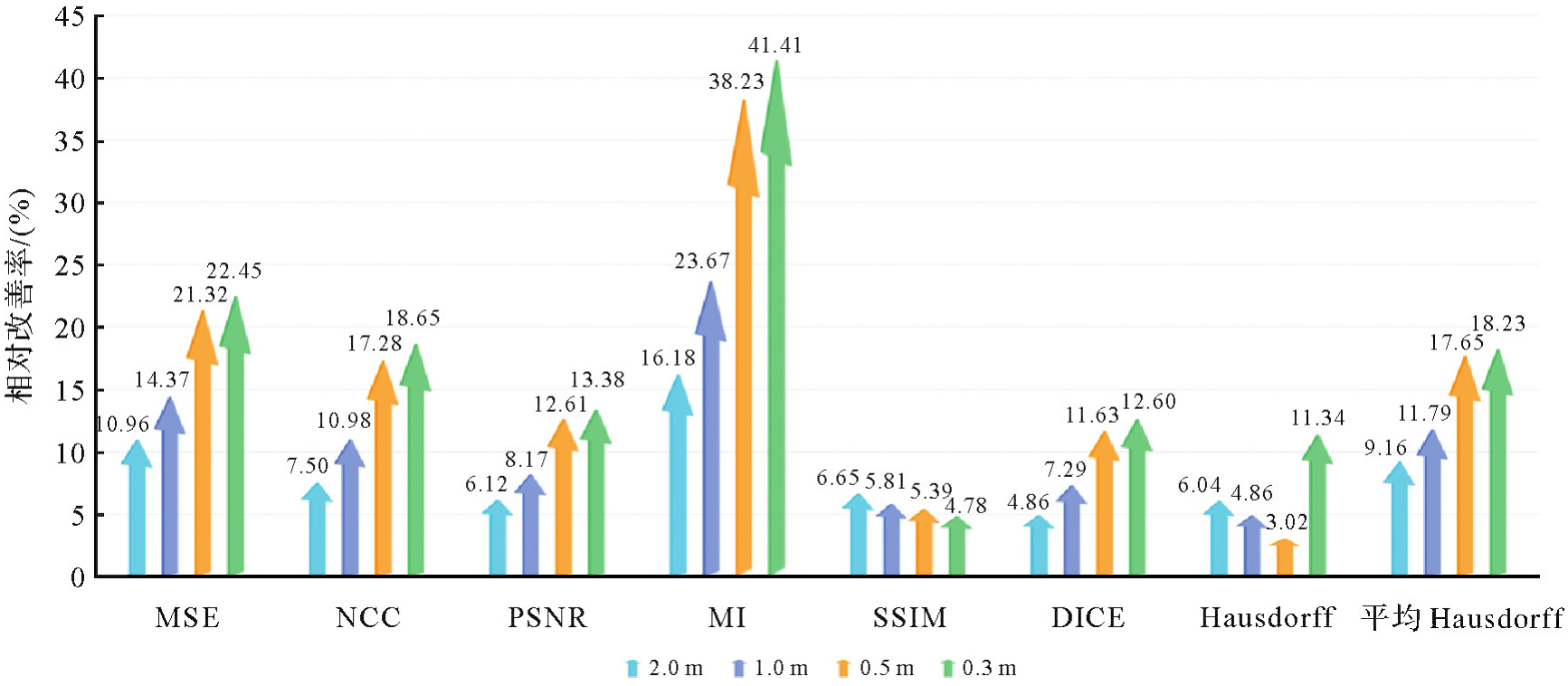
Fig. 9
Relative improvement rates of spatial alignment effectiveness under different rasterization resolutions"
| [1] | 武芳, 王泽根, 蔡忠亮, 等. 空间数据库原理[M]. 武汉: 武汉大学出版社, 2017: 230-231. |
| WU Fang, WANG Zegen, CAI Zhongliang, et al. Spatial database principle[M]. Wuhan: Wuhan University Press, 2017: 230-231. | |
| [2] | 杨飞, 华一新, 李响, 等. 基于多粒度时空对象数据模型的城市基础设施建模与管理[J]. 地球信息科学学报, 2021, 23(11): 1984-1997. |
| YANG Fei, HUA Yixin, LI Xiang, et al. An urban facilities modeling and management method based on the multi-granularity spatiotemporal object data model[J]. Journal of Geo-information Science, 2021, 23(11): 1984-1997. | |
| [3] | 张新长, 华淑贞, 齐霁, 等. 新型智慧城市建设与展望:基于AI的大数据、大模型与大算力[J]. 地球信息科学学报, 2024, 26(4): 779-789. |
| ZHANG Xinchang, HUA Shuzhen, QI Ji, et al. Progress and prospects of new smart city construction: AI-based big data, big models and big computing power[J]. Journal of Geo-information Science, 2024, 26(4): 779-789. | |
| [4] |
张永军, 张祖勋, 龚健雅. 天空地多源遥感数据的广义摄影测量学[J]. 测绘学报, 2021, 50(1): 1-11. DOI: .
doi: 10.11947/j.AGCS.2021.20200245 |
|
ZHANG Yongjun, ZHANG Zuxun, GONG Jianya. Generalized photogrammetry of spaceborne, airborne and terrestrial multi-source remote sensing datasets[J]. Acta Geodaetica et Cartographica Sinica, 2021, 50(1): 1-11. DOI: .
doi: 10.11947/j.AGCS.2021.20200245 |
|
| [5] | 李德仁. 新基建时代地理信息产业的机遇与挑战[J]. 中国工业和信息化, 2020(12): 52-57. |
| LI Deren. Opportunities and challenges of geographic information industry in the new infrastructure era[J]. China Industry & Information Technology, 2020(12): 52-57. | |
| [6] | 杨明旺, 赵丽科, 叶林峰, 等. 基于卷积神经网络的遥感影像建筑物提取方法综述[J]. 地球信息科学学报, 2024, 26(6): 1500-1516. |
| YANG Mingwang, ZHAO Like, YE Linfeng, et al. A review of convolutional neural networks related methods for building extraction from remote sensing images[J]. Journal of Geo-information Science, 2024, 26(6): 1500-1516. | |
| [7] | DOYTSHER Y. A rubber sheeting algorithm for non-rectangular maps[J]. Computers & Geosciences, 2000, 26(9/10): 1001-1010. |
| [8] | WEI R, MURRAY A T. An integrated approach for addressing geographic uncertainty in spatial optimization[J]. International Journal of Geographical Information Science, 2012, 26(7): 1231-1249. |
| [9] | 赵东保, 盛业华, 张卡. 利用几何矩和叠置分析进行多尺度面要素自动匹配[J]. 武汉大学学报(信息科学版), 2011, 36(11): 1371-1375. |
| ZHAO Dongbao, SHENG Yehua, ZHANG Ka. An algorithm for muti-scale one-to-many areal feature matching based on geometry moments and overly analysis[J]. Geomatics and Information Science of Wuhan University, 2011, 36(11): 1371-1375. | |
| [10] | 刘凌佳. 多尺度面实体匹配方法及其融合应用研究[D]. 武汉: 武汉大学, 2018. |
| LIU Lingjia. Research on methods and integration applications of polygonal object matching on multi-scale datasets[D]. Wuhan: Wuhan University, 2018. | |
| [11] | CHEN S, SHI W, ZHOU M, et al. CDasXORNet: change detection of buildings from bi-temporal remote sensing images as an XOR problem[J]. International Journal of Applied Earth Observation and Geoinformation, 2024, 130(1): 103836. |
| [12] | TONG Xiaohua, LIANG Dan, JIN Yanmin. A linear road object matching method for conflation based on optimization and logistic regression[J]. International Journal of Geographical Information Science, 2014, 28(4): 824-846. |
| [13] | WANG Yanxia, CHEN Deng, ZHAO Zhiyuan, et al. A back-propagation neural network-based approach for multi-represented feature matching in update propagation[J]. Transactions in GIS, 2015, 19(6): 964-993. |
| [14] | 李德仁, 龚健雅, 张桥平. 论地图数据库合并技术[J]. 测绘科学, 2004, 29(1): 1-4. |
| LI Deren, GONG Jianya, ZHANG Qiaoping. On the conflation of geographic databases[J]. Science of Surveying and Mapping, 2004, 29(1): 1-4. | |
| [15] |
张新长, 何显锦, 孙颖, 等. 多尺度空间数据联动更新技术研究现状及展望[J]. 测绘学报, 2022, 51(7): 1520-1535. DOI: .
doi: 10.11947/j.AGCS.2022.20220095 |
|
ZHANG Xinchang, HE Xianjin, SUN Ying, et al. Advance and future development of the multi-scale spatial data linkage updating[J]. Acta Geodaetica et Cartographica Sinica, 2022, 51(7): 1520-1535. DOI: .
doi: 10.11947/j.AGCS.2022.20220095 |
|
| [16] | SCHORCHT M, HECHT R, MEINEL G. Comparative study on matching methods for the distinction of building modifications and replacements based on multi-temporal building footprint data[J]. ISPRS International Journal of Geo-Information, 2022, 11(2): 91-107. |
| [17] | DUAN Weiwei, CHIANG Yaoyi, LEYK S, et al. Automatic alignment of contemporary vector data and georeferenced historical maps using reinforcement learning[J]. International Journal of Geographical Information Science, 2020, 34(4): 824-849. |
| [18] | 翟仁健. 基于全局一致性评价的多尺度矢量空间数据匹配方法研究[D]. 郑州: 信息工程大学, 2011. |
| ZHAI Renjian. Research on automated matching methods for multi-scale vector spatial data based on global consistency evaluation[D]. Zhengzhou: Information Engineering University, 2011. | |
| [19] | 蓝振家. 顾及邻域相似性的面实体匹配最优化方法[D]. 武汉: 武汉大学, 2019. |
| LAN Zhenjia. Optimization method for areal feature matching considering context-dependent similarity[D]. Wuhan: Wuhan University, 2019. | |
| [20] | 朱欣焰, 刘凌佳. 一种用于空间数据整合的建筑物面实体对齐方法[J]. 武汉大学学报(信息科学版), 2018, 43(12): 2269-2277. |
| ZHU Xinyan, LIU Lingjia. A building polygonal object alignment approach for spatial data integration[J]. Geomatics and Information Science of Wuhan University, 2018, 43(12): 2269-2277. | |
| [21] | 张付兵, 温伯威, 郭丽萍, 等. 基于机器学习的多源矢量同名面实体几何不一致性识别和处理方法[J]. 测绘科学技术学报, 2024, 40(4): 411-417. |
| ZHANG Fubing, WEN Bowei, GUO Liping, et al. A method for recognizing and processing geometric inconsistencies in multi-source identical polygonal vector entities based on machine learning[J]. Journal of Geomatics Science and Technology, 2024, 40(4): 411-417. | |
| [22] | KOVALERCHUK B, DOUCETTE P, SEEDAHMED G, et al. Automated vector-to-raster image registration[C]//Proceedings of 2008 Algorithms and Technologies for Multispectral, Hyperspectral, and Ultraspectral Imagery XIV. Orlando: SPIE, 2008: 69660W. |
| [23] | 杜永葛, 霍亮, 程宏宇, 等. 矢量数据校正工具集的设计与实现[J]. 矿山测量, 2017, 45(1): 9-13. |
| DU Yongge, HUO Liang, CHENG Hongyu, et al. Design and implementation of vector data correction toolkit[J]. Mine Survey, 2017, 45(1): 9-13. | |
| [24] | 王艳东, 邵鑫, 刘波, 等. 一种利用Mask R-CNN的遥感影像与矢量数据配准方法[J]. 武汉大学学报(信息科学版), 2022, 47(4): 623-631. |
| WANG Yandong, SHAO Xin, LIU Bo, et al. A registration method of remote sensing image and vector data using mask R-CNN[J]. Geomatics and Information Science of Wuhan University, 2022, 47(4): 623-631. | |
| [25] | RUIZ-LENDÍNEZ J J, MAĆKIEWICZ B, MOTEK P, et al. Method for an automatic alignment of imagery and vector data applied to cadastral information in Poland[J]. Survey Review, 2019, 51(365): 123-134. |
| [26] | YUAN Lang, LI Yuxia, YANG Chao, et al. Road vectorization based on image pixel tracking and attribute matching method[C]//Proceedings of 2020 IEEE International Geoscience and Remote Sensing Symposium. Waikoloa: IEEE, 2020: 3199-3202. |
| [27] | FAN Hongchao, ZIPF A, FU Qing, et al. Quality assessment for building footprints data on OpenStreetMap[J]. International Journal of Geographical Information Science, 2014, 28(4): 700-719. |
| [28] | 郝燕玲, 唐文静, 赵玉新, 等. 基于空间相似性的面实体匹配算法研究[J]. 测绘学报, 2008, 37(4): 501-506. |
| HAO Yanling, TANG Wenjing, ZHAO Yuxin, et al. Areal feature matching algorithm based on spatial similarity[J]. Acta Geodaetica et Cartographica Sinica, 2008, 37(4): 501-506. | |
| [29] | 汪汇兵, 唐新明, 邱博, 等. 运用多算子加权的面要素几何匹配方法[J]. 武汉大学学报(信息科学版), 2013, 38(10): 1243-1247. |
| WANG Huibing, TANG Xinming, QIU Bo, et al. Geometric matching method of area feature based on multi-weighted operators[J]. Geomatics and Information Science of Wuhan University, 2013, 38(10): 1243-1247. | |
| [30] | LIU Lingjia, DING Xiaohui, ZHU Xinyan, et al. An iterative approach based on contextual information for matching multi-scale polygonal object datasets[J]. Transactions in GIS, 2020, 24(4): 1047-1072. |
| [31] | 郭黎, 崔铁军, 郑海鹰, 等. 基于空间方向相似性的面状矢量空间数据匹配算法[J]. 测绘科学技术学报, 2008(5): 380-382. |
| GUO Li, CUI Tiejun, ZHENG Haiying, et al. Arithmetic for area vector spatial data matching on spatial direction similarity[J]. Journal of Geomatics Science and Technology, 2008(5): 380-382. | |
| [32] | 邵世维. 基于几何特征的多尺度矢量面状实体匹配方法研究与应用[D]. 武汉: 武汉大学, 2012. |
| SHAO Shiwei. Researches and applications on polygon entity matching for multi-scale vector data based on geometric features[D]. Wuhan: Wuhan University, 2012. | |
| [33] | POTJE G, CADAR F, ARAUJO A, et al. XFeat: accelerated features for lightweight image matching[C]//Proceedings of 2024 IEEE/CVF Conference on Computer Vision and Pattern Recognition. Seattle: IEEE, 2024: 2682-2691. |
| [34] | LOWE D G. Object recognition from local scale-invariant features[C]//Proceedings of the 7th IEEE International Conference on Computer Vision. Kerkyra: IEEE, 1999: 1150-1157. |
| [35] | BAY H, TUYTELAARS T, VAN GOOL L. SURF: speeded up robust features[M]//Computer Vision-ECCV 2006. Berlin: Springer, 2006: 404-417. |
| [36] | RUBLEE E, RABAUD V, KONOLIGE K, et al. ORB: an efficient alternative to SIFT or SURF[C]//Proceedings of 2011 International Conference on Computer Vision. Barcelona: IEEE, 2011: 2564-2571. |
| [37] | XU Shibiao, CHEN Shunpeng, XU Rongtao, et al. Local feature matching using deep learning: a survey[J]. Information Fusion, 2024, 107: 102344. |
| [38] | BALAKRISHNAN G, ZHAO A, SABUNCU M R, et al. VoxelMorph: a learning framework for deformable medical image registration[J]. IEEE Transactions on Medical Imaging, 2019, 38(8): 1788-1800. |
| [39] | MENG Mingyuan, BI Lei, FENG Dagan, et al. Non-iterative coarse-to-fine registration based on single-pass deep cumulative learning[M]//Medical Image Computing and Computer Assisted Intervention-MICCAI 2022. Cham: Springer Nature Switzerland, 2022: 88-97. |
| [40] | MENG Mingyuan, BI Lei, FULHAM M, et al. Non-iterative coarse-to-fine Transformer networks for joint affine and deformable image registration[M]//Medical Image Computing and Computer Assisted Intervention-MICCAI 2023. Cham: Springer Nature Switzerland, 2023: 750-760. |
| [41] | AI Tinghua, ZHANG Xiang, ZHOU Qi, et al. A vector field model to handle the displacement of multiple conflicts in building generalization[J]. International Journal of Geographical Information Science, 2015, 29(8): 1310-1331. |
| [42] | XU Yongyang, LI Jun, XIE Xuejing, et al. Matching the building footprints of different vector spatial datasets at a similar scale based on one-class support vector machines[J]. International Journal of Geographical Information Science, 2024, 38(8): 1555-1582. |
| [1] | Wanzeng LIU, Xinpeng WANG, Tingting ZHAO, Xi ZHAI, Ran LI, Xiuli ZHU, Zhihao JIANG, Yunlu PENG, Ye ZHANG. Scale evaluation method for fragmented terrain vector data [J]. Acta Geodaetica et Cartographica Sinica, 2024, 53(6): 1013-1024. |
| [2] | LI Hao, YUE Peng, JIANG Liangcun, ZHANG Mingda, LIANG Zheheng. Blockchain technology for vector geographic provenance information organization and verification [J]. Acta Geodaetica et Cartographica Sinica, 2021, 50(6): 823-832. |
| [3] | XIE Peng, YANG Chuncheng, XIONG Shun, HE Liesong, ZHOU Xiaodong. Design and optimization of spatial vector data storage model based on HBase [J]. Acta Geodaetica et Cartographica Sinica, 2020, 49(10): 1365-1373. |
| [4] | TONG Deyu, ZHU Changqing, REN Na. Watermarking Algorithm Applying to Small Amount of Vector Geographical Data [J]. Acta Geodaetica et Cartographica Sinica, 2018, 47(11): 1518-1525. |
| [5] | SUN Qun. Research on the Progress of Multi-sources Geospatial Vector Data Fusion [J]. Acta Geodaetica et Cartographica Sinica, 2017, 46(10): 1627-1636. |
| [6] | . Research on Registration Method between Vector Data and Image Data based on Shape Feature [J]. Acta Geodaetica et Cartographica Sinica, 2014, 43(8): 879-879. |
| [7] | MA Xiaolong LI Chengming ZHAO Zhanjie. Three-dimensional Road Intersection Automatic Inspection and Robotization Modeling Based on OSG [J]. Acta Geodaetica et Cartographica Sinica, 2014, 43(10): 1083-1091. |
| [8] | 1,. Robust Watermarking Algorithm for Geometrical Transform for Vector Geo-spatial Data Based on Invariant Function [J]. Acta Geodaetica et Cartographica Sinica, 2011, 40(2): 256-261. |
| Viewed | ||||||
|
Full text |
|
|||||
|
Abstract |
|
|||||