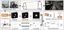
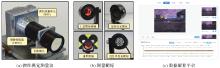
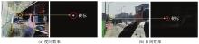
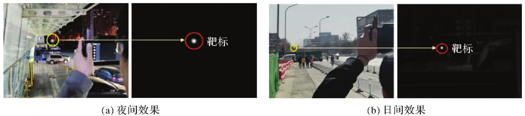
| [1] |
许俊伟, 刘永胜, 吴达, 等. 隧道与地下工程监控量测技术的发展与展望[J]. 测绘地理信息, 2023, 48(3): 7-13.
|
|
XU Junwei, LIU Yongsheng, WU Da, et al. Development and outlook of monitoring and measuring technologies of tunnel and underground engineering[J]. Journal of Geomatics, 2023, 48(3): 7-13.
|
| [2] |
ZHOU Jianguo, XIAO Henglin, JIANG Weiwei, et al. Automatic subway tunnel displacement monitoring using robotic total station[J]. Measurement, 2020, 151: 107251.
|
| [3] |
刘龙龙, 张继贤, 赵争, 等. GB-SAR变形监测技术研究现状与展望[J]. 测绘通报, 2019(11): 1-7.
|
|
LIU Longlong, ZHANG Jixian, ZHAO Zheng, et al. Research status and prospects of GB-SAR deformation monitoring technology[J]. Bulletin of Surveying and Mapping, 2019(11): 1-7.
|
| [4] |
LONG S, YUAN X, LU S, et al. Solid model bridge static damage monitoring based on GB-SAR[J]. The Journal of Geodesy and Geoinformation Science, 2022, 5(4): 38-49.
|
| [5] |
SHEN Yueqian, WANG Jinguo, WANG Jinhu, et al. Methodology for extraction of tunnel cross-sections using dense point cloud data[J]. The Journal of Geodesy and Geoinformation Science, 2021, 4(2): 56-71.
|
| [6] |
陈柱, 商长君, 杨建超, 等. 三维可视化激光扫描技术在隧道变形监测中的应用[J]. 铁道勘察, 2022, 48(4): 29-35.
|
|
CHEN Zhu, SHANG Changjun, YANG Jianchao, et al. Application of 3D visualized laser scanning technology in tunnel deformation monitoring[J]. Railway Investigation and Surveying, 2022, 48(4): 29-35.
|
| [7] |
侯公羽, 李子祥, 胡涛, 等. 用于隧道变形监测的分布式光纤定点式布设监测误差测定研究[J]. 岩土力学, 2020, 41(10): 3481-3490.
|
|
HOU Gongyu, LI Zixiang, HU Tao, et al. Study on monitoring error of distributed optical fiber using fixed-point layout for tunnel deformation monitoring[J]. Rock and Soil Mechanics, 2020, 41(10): 3481-3490.
|
| [8] |
GOLMOHAMMADI A, HASHEMINEJAD N, VANDEN BERGH W. Enhancing roads infrastructure monitoring with FBG sensors and multi-threshold signal tracking[J]. E-journal of Nondestructive Testing, 2024, 29(7): 1-8.
|
| [9] |
殷煜, 李清泉, 余建伟, 等. 基于管道测量机器人的高堆石坝内部沉降测量方法[J]. 岩土工程学报, 2022, 44(10): 1951-1958.
|
|
YIN Yu, LI Qingquan, YU Jianwei, et al. Measuring method for internal settlement of high rockfill dams based on pipeline measuring robot[J]. Chinese Journal of Geotechnical Engineering, 2022, 44(10): 1951-1958.
|
| [10] |
李清泉, 谷宇, 涂伟, 等. 利用管道胶囊进行排水管网协同检测的新方法[J]. 武汉大学学报(信息科学版), 2021, 46(8): 1123-1130.
|
|
LI Qingquan, GU Yu, TU Wei, et al. Collaborative inspection for the sewer pipe network using pipe capsules[J]. Geomatics and Information Science of Wuhan University, 2021, 46(8): 1123-1130.
|
| [11] |
李清泉, 陈睿哲, 涂伟, 等. 基于惯性相机的大跨度桥梁线形形变实时测量方法[J]. 武汉大学学报(信息科学版), 2023, 48(11): 1834-1843.
|
|
LI Qingquan, CHEN Ruizhe, TU Wei, et al. Real-time vision-based deformation measurement of long-span bridge with inertial sensors[J]. Geomatics and Information Science of Wuhan University, 2023, 48(11): 1834-1843.
|
| [12] |
孟丽媛. 多源信息辅助影像的形变监测关键技术研究[D]. 武汉: 武汉大学, 2021.
|
|
MENG Liyuan. Research on the key technologies of deformation monitoring based on image assisted by multi-source information[D]. Wuhan: Wuhan University, 2021.
|
| [13] |
HU Biao, CHEN Wenjun, ZHANG Yueqiang, et al. Vision-based multi-point real-time monitoring of dynamic displacement of large-span cable-stayed bridges[J]. Mechanical Systems and Signal Processing, 2023, 204: 110790.
|
| [14] |
RIBEIRO D, SANTOS R, CABRAL R, et al. Non-contact structural displacement measurement using unmanned aerial vehicles and video-based systems[J]. Mechanical Systems and Signal Processing, 2021, 160: 107869.
|
| [15] |
ZHU Aixi. A novel high-precision photogrammetric technique for monitoring subway tunnel deformation[J]. Structures, 2023, 55: 2217-2231.
|
| [16] |
ZHU Min, RAO Wei, HONG Chengyu, et al. Displacement measurement of underground prefabricated metro stations by computer vision technology[J]. Measurement, 2024, 231: 114500.
|
| [17] |
李清泉, 张德津, 汪驰升, 等. 动态精密工程测量技术及应用[J]. 测绘学报, 2021, 50(9): 1147-1158. DOI: .
doi: 10.11947/j.AGCS.2021.20210172
|
|
LI Qingquan, ZHANG Dejin, WANG Chisheng, et al. Technology and applications of dynamic and precise engineering surveying[J]. Acta Geodaetica et Cartographica Sinica, 2021, 50(9): 1147-1158. DOI: .
doi: 10.11947/j.AGCS.2021.20210172
|
| [18] |
LU Changsheng, XIA Siyu, SHAO Ming, et al. Arc-support line segments revisited: an efficient high-quality ellipse detection. IEEE Transactions on Image Processing, 2020, 29: 768-781.
|
| [19] |
HAHN K, HAN Y, HAHN H. Ellipse detection using a randomized Hough transform based on edge segment merging scheme[C]//Proceedings of the 6th WSEAS International Conference on Signal Processing, Robotics and automation. Hangzhou: IEEE, 2007: 1-6.
|
| [20] |
陈余根, 杨艳. 基于霍夫变换椭圆检测的两种改进算法[J]. 半导体光电, 2017, 38(5): 745-750.
|
|
CHEN Yugen, YANG Yan. Two improved algorithms for ellipse detection based on Hough transform[J]. Semiconductor Optoelectronics, 2017, 38(5): 745-750.
|
| [21] |
WANG Jian, HAN Houzeng, LIU Fei, et al. Performance analysis of GNSS/MIMU tight fusion positioning model with complex scene feature constraints[J]. The Journal of Geodesy and Geoinformation Science, 2021, 4(2): 1-13.
|
| [22] |
FAKHARIAN A, GUSTAFSSON T, MEHRFAM M. Adaptive Kalman filtering based navigation: an IMU/GPS integration approach[C]//Proceedings of 2011 International Conference on Networking, Sensing and Control. Delft: IEEE, 2011: 181-185.
|
| [23] |
FENG Daquan, WANG Chunqi, HE Chunlong, et al. Kalman-filter-based integration of IMU and UWB for high-accuracy indoor positioning and navigation[J]. IEEE Internet of Things Journal, 2020, 7(4): 3133-3146.
|
| [24] |
CHEN I H, HO S C, SU M B. Computer vision application programming for settlement monitoring in a drainage tunnel[J]. Automation in Construction, 2020, 110: 103011.
|
| [25] |
QIU Zurong, LI Haopeng, HU Wenchuan, et al. Real-time tunnel deformation monitoring technology based on laser and machine vision[J]. Applied Sciences, 2018, 8(12): 2579.
|
| [26] |
中国国家铁路集团有限公司. 铁路隧道监控量测技术规程:Q/CR 9218—2024[S]. 北京: 中国铁道出版社, 2024.
|
|
China National Railway Group Co., Ltd.. Technical specification for monitoring and measurement of railway tunnels: Q/CR 9218—2024[S]. Beijing: China Railway Publishing House, 2024.
|
| [27] |
马沁巍. 温度导致的光测力学方法误差产生机理及校正研究[D]. 北京: 北京理工大学, 2014.
|
|
MA Qinwei. Mechanism and correction of the error in photomechanics methods induced by temperature[D]. Beijing: Beijing Institute of Technology, 2014.
|
| [28] |
ZHOU Shichao, ZHU Haibin, MA Qqinwei, et al. Mechanism and compensation of measurement error induced by thermal deformation of digital camera in photo mechanics[J]. Applied Sciences, 2020, 10(10): 3422.
|


 ), Boyu CHEN1, Xinlin LIU1, Yun YANG1, Song ZHU1,2,3(