

Acta Geodaetica et Cartographica Sinica ›› 2026, Vol. 55 ›› Issue (3): 490-501.doi: 10.11947/j.AGCS.2026.20250359
• Geodesy and Navigation • Previous Articles Next Articles
Wentao HOU1,2( ), Yun XIAO2,3(), Jie CAO4, Yukang WANG1,2, Chunting CAO1,2, Han WANG1,2
Received:2025-09-25
Revised:2026-03-21
Online:2026-04-16
Published:2026-04-16
Contact:
Yun XIAO
E-mail:2024126031@chd.edu.cn;2262164268@qq.com
About author:HOU Wentao (2002—), male, postgraduate, majors in hydrological applications of satellite gravity. E-mail: 2024126031@chd.edu.cn
Supported by:CLC Number:
Wentao HOU, Yun XIAO, Jie CAO, Yukang WANG, Chunting CAO, Han WANG. A downscaling method for gravity satellite derived groundwater storage changes based on a feature-weighted CatBoost model[J]. Acta Geodaetica et Cartographica Sinica, 2026, 55(3): 490-501.
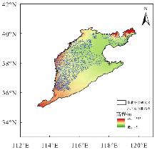
Fig. 1
The North China Plain"
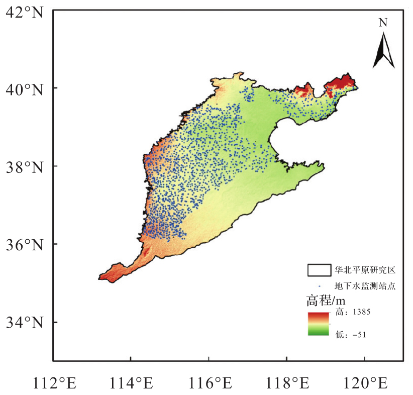
Fig. 2
Regional hydrological cycle system"
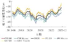
Fig. 3
Time series of groundwater storage variations in the North China Plain before and after weighted fusion"
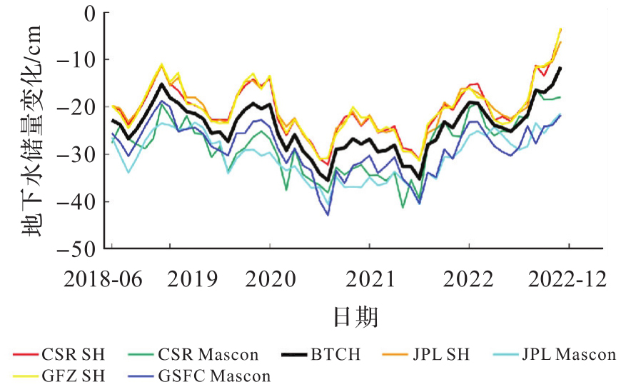
Fig. 4
Spatial distribution of groundwater storage variation trends in the North China Plain after weighted fusion"
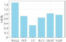
Fig. 5
VIP values of each feature variable"
Tab. 1
Parameters of CatBoost model"
| 参数 | 含义 | 取值 |
|---|---|---|
| task type | 训练的器件GPU | — |
| loss function | 损失函数RMSE | — |
| iterations | 迭代次数 | 450 |
| depth | 树身 | 4 |
| learning_rate | 学习率 | 0.01 |
| l2_leaf_reg | L2正则系数 | 0.05 |
Fig. 6
Groundwater storage variations in the North China Plain before and after downscaling"
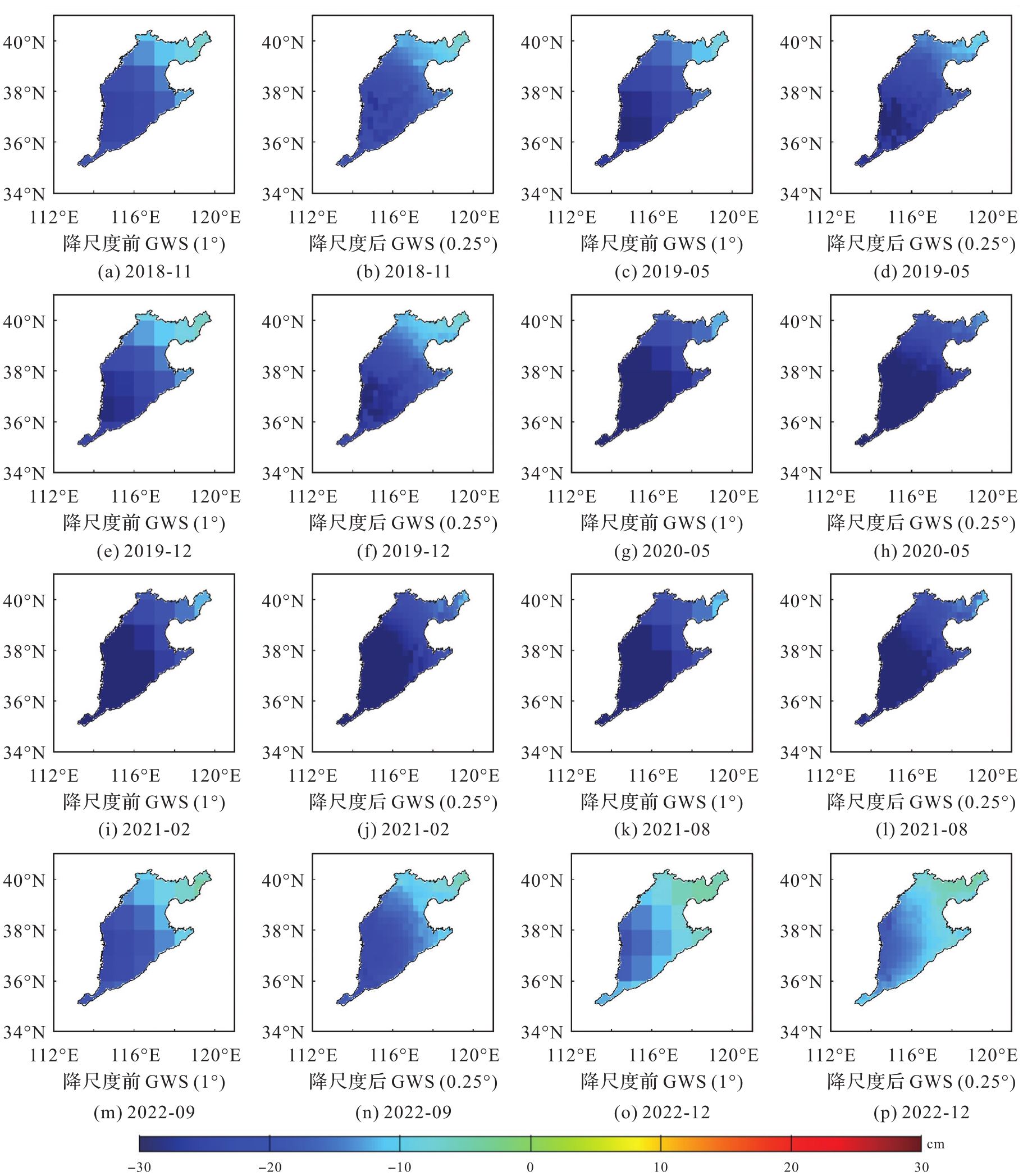
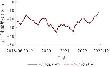
Fig. 7
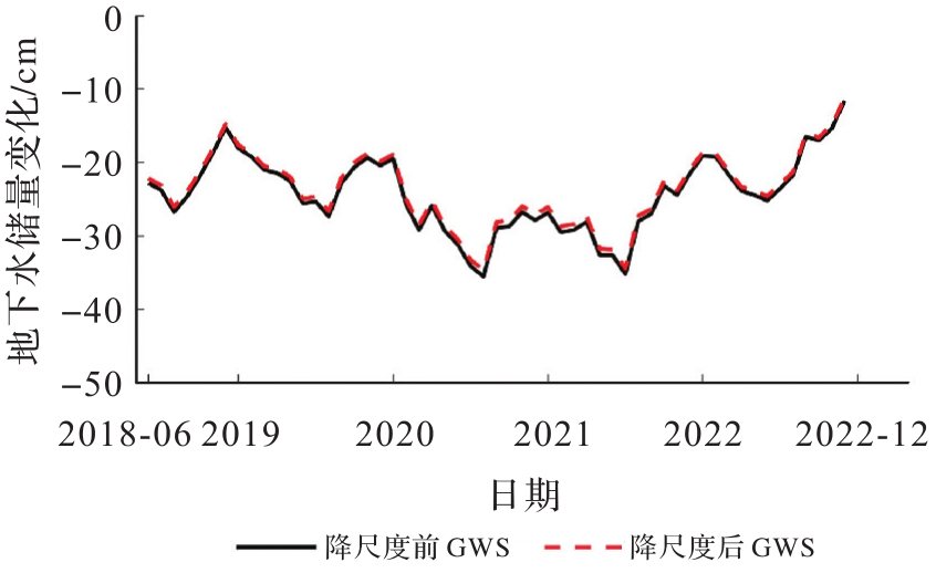
Time series of groundwater storage variations in the North China Plain before and after downscaling"
Tab. 2
Groundwater storage variation trends in the North China Plain before and after downscaling"
| 数据 | 2018-06—2020-12 | 2021-01—2022-12 |
|---|---|---|
| 降尺度前 | -4.5±1.0 | 8.1±1.2 |
| 降尺度后 | -4.4±1.0 | 7.9±1.2 |
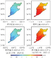
Fig. 8
Spatial distribution of groundwater storage variation trends in the North China Plain before and after downscaling"
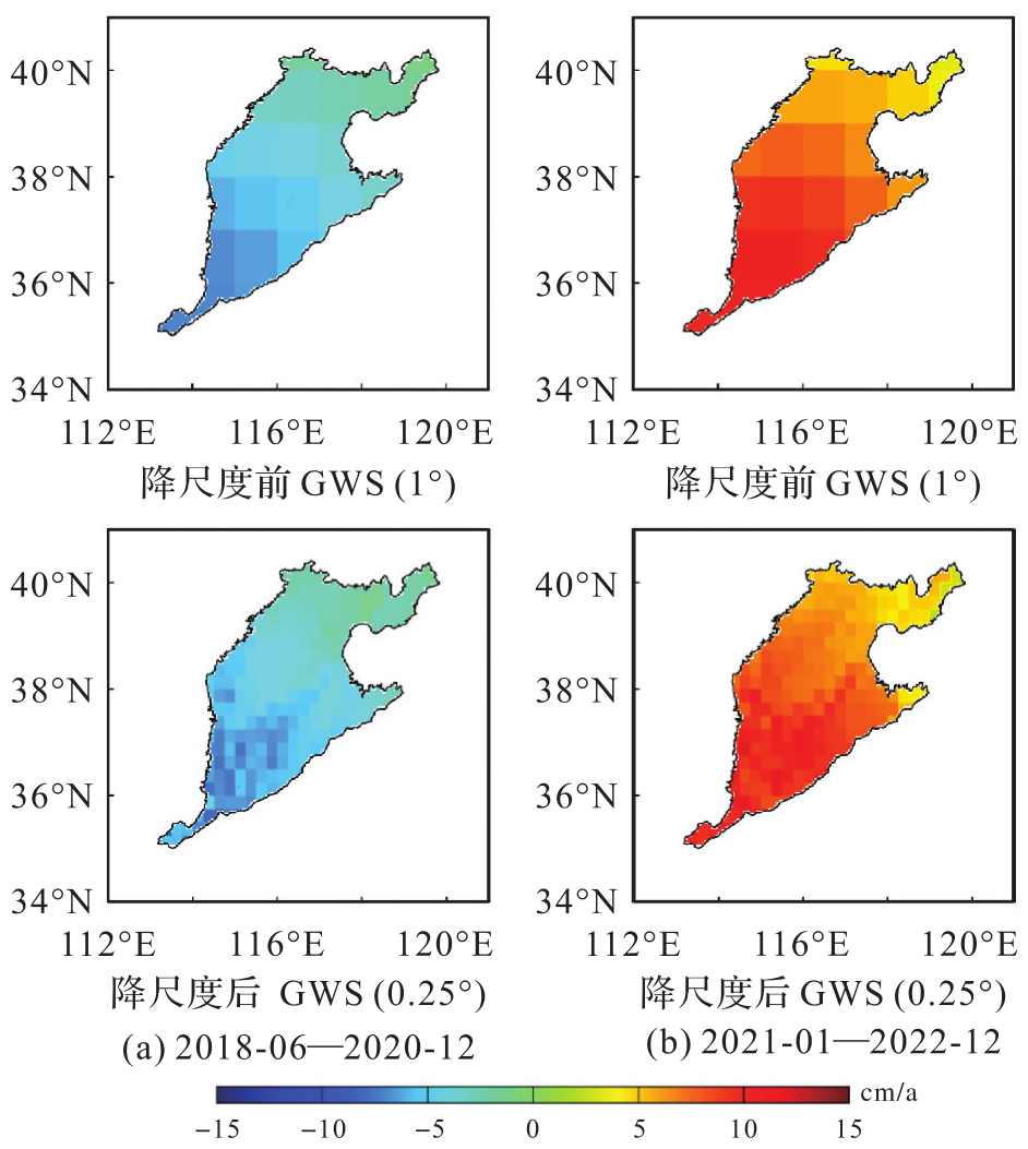
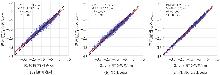
Fig. 9
Comparison of regression analysis results from the three downscaling models"
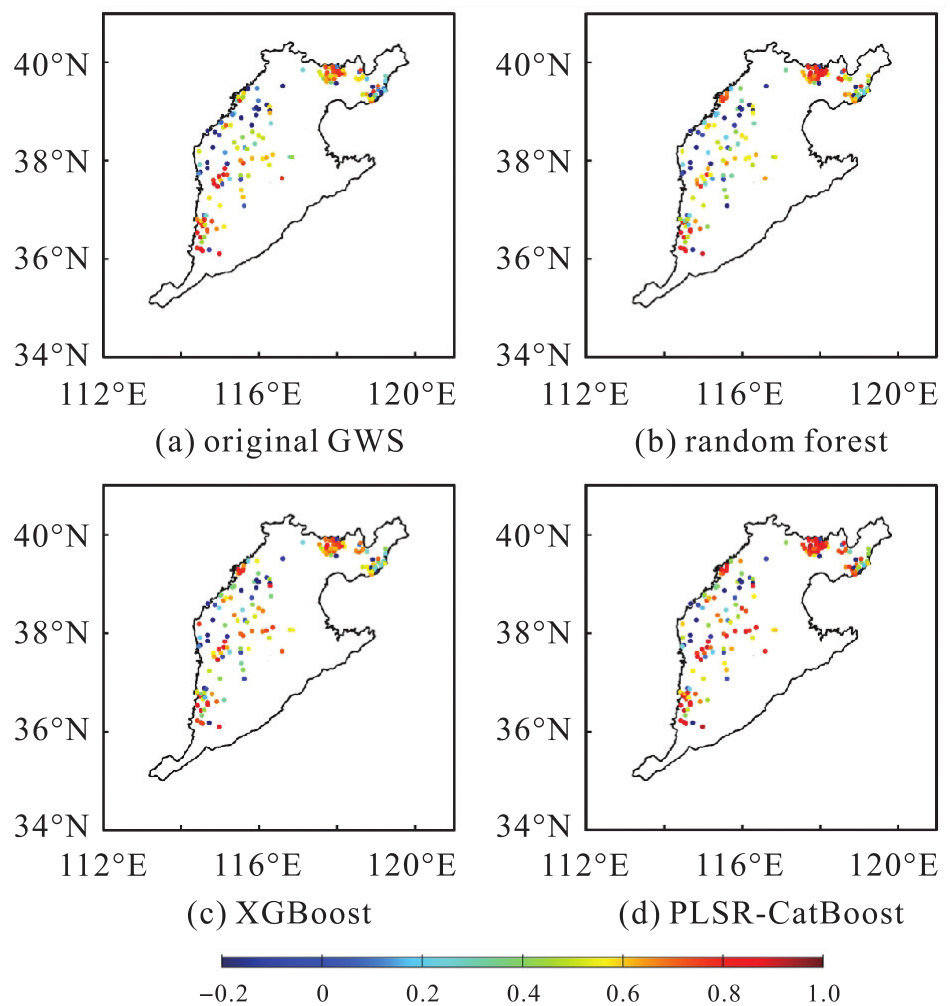
Fig. 10
Correlation between groundwater storage variations before and after downscaling and well water levels"
Tab. 3
Statistical proportions of correlations between groundwater storage variations before and after downscaling and well water level data"
| 数据 | 负相关(-∞,0] | 正相关范围 | ||
|---|---|---|---|---|
| (0,0.2] | (0.2,0.6] | (0.6,1.0] | ||
| 降尺度前 | 15.03% | 10.40% | 34.69% | 39.88% |
| Random Forest | 15.02% | 6.36% | 36.42% | 42.20% |
| XGBoost | 13.87% | 5.20% | 35.84% | 45.09% |
| PLSR-CatBoost | 12.14% | 5.78% | 24.28% | 57.80% |
Tab. 4
Average correlation coefficient between groundwater storage changes before and after downscaling and measured groundwater levels in each subregion"
| 地区 | 降尺度前 | 降尺度后 |
|---|---|---|
| 保定市 | 0.23 | 0.45 |
| 沧州市 | 0.49 | 0.69 |
| 邯郸市 | 0.64 | 0.65 |
| 衡水市 | 0.45 | 0.50 |
| 廊坊市 | -0.04 | 0.19 |
| 秦皇岛市 | 0.33 | 0.51 |
| 石家庄市 | 0.09 | 0.20 |
| 唐山市 | 0.49 | 0.61 |
| 邢台市 | 0.61 | 0.62 |
| 雄安新区 | -0.15 | 0.07 |
| [1] | 冉将军, 闫政文, 吴云龙, 等. 下一代重力卫星任务研究概述与未来展望[J]. 武汉大学学报(信息科学版), 2023, 48(6): 841-857. |
| RAN Jiangjun, YAN Zhengwen, WU Yunlong, et al. Research status and future perspectives in next generation gravity mission[J]. Geomatics and Information Science of Wuhan University, 2023, 48(6): 841-857. | |
| [2] |
刘东旭, 胡立堂, 孙建冲, 等. 基于GRACE/GRACE-FO数据降尺度方法反演库尔勒东区地下水储量变化[J]. 测绘学报, 2024, 53(7): 1265-1277. DOI: .
doi: 10.11947/j.AGCS.2024.20230354 |
|
LIU Dongxu, HU Litang, SUN Jianchong, et al. Retrieval of groundwater storage anomalies in eastern region of Korla by downscaling GRACE/GRACE-FO data[J]. Acta Geodaetica et Cartographica Sinica, 2024, 53(7): 1265-1277. DOI: .
doi: 10.11947/j.AGCS.2024.20230354 |
|
| [3] | FOWLER H J, BLENKINSOP S, TEBALDI C. Linking climate change modelling to impacts studies: recent advances in downscaling techniques for hydrological modelling[J]. International Journal of Climatology, 2007, 27(12): 1547-1578. |
| [4] | WILBY R L, WIGLEY T M L, CONWAY D, et al. Statistical downscaling of general circulation model output: a comparison of methods[J]. Water Resources Research, 1998, 34(11): 2995-3008. |
| [5] | 黄上富, 段光耀, 和继军, 等. 基于GWR模型的海河流域地下水储量降尺度研究[J]. 水电能源科学, 2023, 41(11): 39-42, 30. |
| HUANG Shangfu, DUAN Guangyao, HE Jijun, et al. Downscaling of groundwater storage change in Haihe River Basin based on GWR model[J]. Water Resources and Power, 2023, 41(11): 39-42, 30. | |
| [6] | 褚江东, 粟晓玲, 张特, 等. 基于随机森林模型的GRACE数据3种空间降尺度对比[J]. 湖泊科学, 2024, 36(3): 951-962. |
| CHU Jiangdong, SU Xiaoling, ZHANG Te, et al. Comparison of three spatial downscaling concepts of GRACE data using random forest model[J]. Journal of Lake Sciences, 2024, 36(3): 951-962. | |
| [7] | MIRO M E, FAMIGLIETTI J S. Downscaling GRACE remote sensing datasets to high-resolution groundwater storage change maps of California'scentral valley[J]. Remote Sensing, 2018, 10(1): 143. |
| [8] | SAHOUR H, SULTAN M, VAZIFEDAN M, et al. Statistical applications to downscale GRACE-derived terrestrial water storage data and to fill temporal gaps[J]. Remote Sensing, 2020, 12(3): 533. |
| [9] | SEYOUM W M, KWON D, MILEWSKI A M. Downscaling GRACE TWSA data into high-resolution groundwater level anomaly using machine learning-based models in a glacial aquifer system[J]. Remote Sensing, 2019, 11(7): 824. |
| [10] | 曹杰, 肖云, 龙笛, 等. 联合重力卫星和水井资料监测华北平原地下水储量变化[J]. 武汉大学学报(信息科学版), 2024, 49(5): 805-818. |
| CAO Jie, XIAO Yun, LONG Di, et al. Combined gravity satellite and water well information to monitor groundwater storage changes in the North China Plain[J]. Geomatics and Information Science of Wuhan University, 2024, 49(5): 805-818. | |
| [11] | RODELL M, HOUSER P R, JAMBOR U, et al. The global land data assimilation system[J]. Bulletin of the American Meteorological Society, 2004, 85(3): 381-394. |
| [12] | WAN Z, HOOK S, HULLEY G. MOD11C3 MODIS/Terra land surface temperature/emissivity monthly L3 global 0.05 deg CMG V006.[EB/OL]. [2025-4-15]. https://lpdaac.usgs.gov/products/mod11c3v006/. |
| [13] | 费宇红, 苗晋祥, 张兆吉, 等. 华北平原地下水降落漏斗演变及主导因素分析[J]. 资源科学, 2009, 31(3): 394-399. |
| FEI Yuhong, MIAO Jinxiang, ZHANG Zhaoji, et al. Analysis on evolution of groundwater depression cones and its leading factors in North China Plain[J]. Resources Science, 2009, 31(3): 394-399. | |
| [14] | 朱菊艳, 郭海朋, 李文鹏, 等. 华北平原地面沉降与深层地下水开采关系[J]. 南水北调与水利科技, 2014, 12(3): 165-169. |
| ZHU Juyan, GUO Haipeng, LI Wenpeng, et al. Relationship between land subsidence and deep groundwater yield in the North China Plain[J]. South-to-North Water Transfers and Water Science & Technology, 2014, 12(3): 165-169. | |
| [15] | LOOMIS B D, RACHLIN K E, LUTHCKE S B. Improved earth oblateness rate reveals increased ice sheet losses and mass-driven sea level rise[J]. Geophysical Research Letters, 2019, 46(12): 6910-6917. |
| [16] | ARGUS D F, PELTIER W R, DRUMMOND R, et al. The Antarctica component of postglacial rebound model ICE-6G_C (VM5a) based on GPS positioning, exposure age dating of ice thicknesses, and relative sea level histories[J]. Geophysical Journal International, 2014, 198(1): 537-563. |
| [17] | WAHR J, MOLENAAR M, BRYAN F. Time variability of the Earth's gravity field: hydrological and oceanic effects and their possible detection using GRACE[J]. Journal of Geophysical Research: Solid Earth, 1998, 103(B12): 30205-30229. |
| [18] | CHAMBERS D P. Evaluation of new GRACE time-variable gravity data over the ocean[J]. Geophysical Research Letters, 2006, 33(17): 2006GL027296. |
| [19] | 李婉秋, 王伟, 章传银, 等. 利用GRACE卫星重力数据监测关中地区地下水储量变化[J]. 地球物理学报, 2018, 61(6): 2237-2245. |
| LI Wanqiu, WANG Wei, ZHANG Chuanyin, et al. Monitoring groundwater storage variations in the Guanzhong area using GRACE satellite gravity data[J]. Chinese Journal of Geophysics, 2018, 61(6): 2237-2245. | |
| [20] | CAO Yanping, NAN Zhuotong, CHENG Guodong. GRACE gravity satellite observations of terrestrial water storage changes for drought characterization in the arid land of northwestern China[J]. Remote Sensing, 2015, 7(1): 1021-1047. |
| [21] | 黄飞龙, 谷延超, 何祖建, 等. 贝叶斯三角帽法的GRACE/GRACE-FO组合模型及其不确定性[J]. 大地测量与地球动力学, 2024, 44(4): 417-422. |
| HUANG Feilong, GU Yanchao, HE Zujian, et al. GRACE/GRACE-FO combined model and its uncertainty based on Bayesian three-cornered hat method[J]. Journal of Geodesy and Geodynamics, 2024, 44(4): 417-422. | |
| [22] | 姚朝龙, 李琼, 罗志才, 等. 利用广义三角帽方法评估GRACE反演中国大陆地区水储量变化的不确定性[J]. 地球物理学报, 2019, 62(3): 883-897. |
| YAO Chaolong, LI Qiong, LUO Zhicai, et al. Uncertainties in GRACE-derived terrestrial water storage changes over China's mainland based on a generalized three-cornered hat method[J]. Chinese Journal of Geophysics, 2019, 62(3): 883-897. | |
| [23] | GAO Shengjun, HAO Weifeng, FAN Yi, et al. A multi-source GRACE fusion solution via uncertainty quantification of GRACE-derived terrestrial water storage (TWS) change[J]. Journal of Geophysical Research: Solid Earth, 2023, 128(11): e2023JB026908. |
| [24] | MA Mingde, MA Xuejuan, XIE Yingzhong, et al. Analysis the relationship between ecological footprint (EF) of Ningxia and influencing factors: partial least-squares regression (PLS)[J]. Acta Ecologica Sinica, 2014, 34(3): 682-689. |
| [25] | 刘梦然. 基于机器学习的黄河流域地下水储量降尺度研究[D]. 开封: 河南大学, 2024. |
| LIU Mengran. Downscaling of groundwater storage in yellow river basin based on machine learning[D]. Kaifeng: Henan University, 2024. | |
| [26] | PROKHORENKOVA L, GUSEV G, VOROBEV A, et al. CatBoost: unbiased boosting with categorical features[C]//Proceedings of 2018 Advances in Neural Information Processing Systems 31. New York: Curran Associates, Inc., 2018: 6638-6648. |
| [1] | Peng LI, Jiahan ZHANG, Zhihan WANG, Houjie WANG, Zhenhong LI. A review of intertidal topography reconstruction methods: current status, challenges and trends [J]. Acta Geodaetica et Cartographica Sinica, 2026, 55(4): 571-587. |
| [2] | Zhaofeng DU, Guopeng LI, Zhanke LIU, Xiaming SHANG, Shengjun KANG, Xiaoqiang WANG. Comprehensive analysis of multiple monitoring methods in main subsidence areas [J]. Acta Geodaetica et Cartographica Sinica, 2025, 54(3): 481-492. |
| [3] | Xiaohu LIN, Xin YANG, Wanqiang YAO, Hongwei MA, Bolin MA, Xiongwei MA. A dynamic weighted fusion SLAM method using multi-source sensor data in complex underground spaces [J]. Acta Geodaetica et Cartographica Sinica, 2025, 54(3): 523-535. |
| [4] | Jichao LÜ, Rui ZHANG, Xu HE, Ruikai HONG, Age SHAMA, Guoxiang LIU. Multi-branch network assessment and dynamic change analysis of wide-area landslide susceptibility [J]. Acta Geodaetica et Cartographica Sinica, 2025, 54(1): 104-122. |
| [5] | Dongxu LIU, Litang HU, Jianchong SUN, Qi CHENG, Yixuan MA, Xin LIU. Retrieval of groundwater storage anomalies in eastern region of Korla by downscaling GRACE/GRACE-FO data [J]. Acta Geodaetica et Cartographica Sinica, 2024, 53(7): 1265-1277. |
| [6] | WANG Yankun, FAN Hong, FAN Yong, LI Xiaoming, WANG Weixi, GUO Renzhong. A “near” relation enhanced multi-sourced data fusion indoor positioning method [J]. Acta Geodaetica et Cartographica Sinica, 2024, 53(1): 118-125. |
| [7] | ZHANG Bing, GAO Lianru, LI Jiaxin, HONG Danfeng, ZHENG Ke. Advances and prospects in hyperspectral and multispectral remote sensing image super-resolution fusion [J]. Acta Geodaetica et Cartographica Sinica, 2023, 52(7): 1074-1089. |
| [8] | SUN Genyun, WANG Xin, AN Na, ZHANG Aizhu. A method for large-scale and high-resolution impervious surface extraction based on multi-source remote sensing and deep learning [J]. Acta Geodaetica et Cartographica Sinica, 2023, 52(2): 272-282. |
| [9] | YAO Chaolong, CHEN Yongxin, LUO Zhicai, LI Qiong, YE Xuemiao, WEN Jinjie. A drought index derived from a combination of GNSS GRACE/GRACE-FO and meteorological data [J]. Acta Geodaetica et Cartographica Sinica, 2023, 52(11): 1883-1891. |
| [10] | YANG Yuanxi, WANG Jianrong. Ubiquitous perception and space mapping [J]. Acta Geodaetica et Cartographica Sinica, 2023, 52(1): 1-7. |
| [11] | LIU Jiping, WANG Yong, HU Yanzhu, LUO An, CHE Xianghong, LI Pengpeng, CAO Yuanhui. A review of web-based ubiquitous geospatial information discovery and integration technology [J]. Acta Geodaetica et Cartographica Sinica, 2022, 51(7): 1618-1628. |
| [12] | LIU Yang, WU Ziyin, ZHAO Dineng, ZHOU Jieqiong, SHANG Jihong, WANG Mingwei, ZHU Chao, LU Haohao. The MF method for multi-source bathymetric data fusion and ocean bathymetric model construction [J]. Acta Geodaetica et Cartographica Sinica, 2019, 48(9): 1171-1181. |
| [13] | ZHAO Yi, JIANG Mi. Integration of SAR polarimetric parameters and multi-spectral data for object-based land cover classification [J]. Acta Geodaetica et Cartographica Sinica, 2019, 48(5): 609-617. |
| [14] | KE Baogui, ZHANG Liming, ZHANG Chuanyin, DANG Yamin. Fusion the Altimetric and Shipborne Gravity Data Based on Point Mass Fit Method [J]. Acta Geodaetica et Cartographica Sinica, 2018, 47(7): 924-929. |
| [15] | LIANG Fuxun, YANG Bisheng, HUANG Ronggang, DONG Zhen, LI Jianping. Façade Solar Potential Analysis Using Multisource Point Cloud [J]. Acta Geodaetica et Cartographica Sinica, 2018, 47(2): 225-233. |
| Viewed | ||||||
|
Full text |
|
|||||
|
Abstract |
|
|||||