

Acta Geodaetica et Cartographica Sinica ›› 2025, Vol. 54 ›› Issue (1): 104-122.doi: 10.11947/j.AGCS.2025.20240014
• Photogrammetry and Remote Sensing • Previous Articles Next Articles
Jichao LÜ( ), Rui ZHANG(), Xu HE, Ruikai HONG, Age SHAMA, Guoxiang LIU
Received:2024-01-09
Revised:2024-12-10
Online:2025-02-17
Published:2025-02-17
Contact:
Rui ZHANG
E-mail:lvjichao@my.swjtu.edu.cn;zhangrui@swjtu.edu.cn
About author:LÜ Jichao (1996—), male, PhD candidate, majors in intelligent monitoring and risk assessment of landslides. E-mail: lvjichao@my.swjtu.edu.cn
Supported by:CLC Number:
Jichao LÜ, Rui ZHANG, Xu HE, Ruikai HONG, Age SHAMA, Guoxiang LIU. Multi-branch network assessment and dynamic change analysis of wide-area landslide susceptibility[J]. Acta Geodaetica et Cartographica Sinica, 2025, 54(1): 104-122.
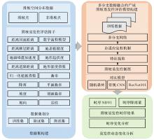
Fig. 1
Flowchart of landslide susceptibility assessment in multi-branch network mode"


Fig. 2
Multi-branch network model"
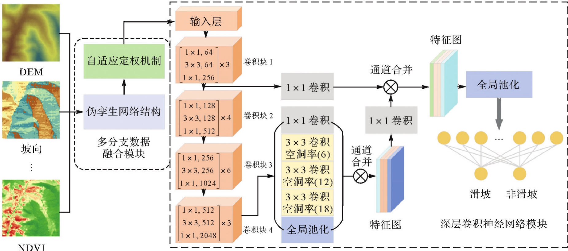
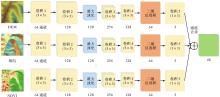
Fig. 3
Pseudo-siamese network architecture"

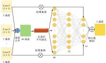
Fig. 4
Adaptive weighting mechanisms"

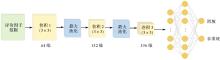
Fig. 5
Shallow CNN network structure"
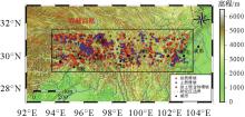
Fig. 6
Study area"

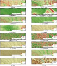
Fig. 7
Landslide susceptibility assessment factors"

Tab. 1
Data sources"
| 数据 | 来源 | 数据 | 来源 |
|---|---|---|---|
| DEM | 地表粗糙度 | 30 m SRTM DEM | |
| 地层岩性 | 地形起伏度 | 30 m SRTM DEM | |
| 断层 | 地形湿度指数 | 30 m SRTM DEM | |
| 地面峰值加速度 | 曲率 | 30 m SRTM DEM | |
| 河流 | 平面曲率 | 30 m SRTM DEM | |
| 道路 | 剖面曲率 | 30 m SRTM DEM | |
| 降雨 | 坡向 | 30 m SRTM DEM | |
| NDVI | GEE/Landsat-8 | 坡度 | 30 m SRTM DEM |
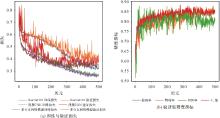
Fig. 8
Model training loss and accuracy variation"

Tab. 2
Comparative experimental accuracy evaluation"
| 模型 | 准确度 | 精确度 | 召回率 | F1值 |
|---|---|---|---|---|
| 随机森林 | 0.77 | 0.78 | 0.78 | 0.78 |
| 浅层CNN | 0.70 | 0.66 | 0.87 | 0.75 |
| ResNet101 | 0.74 | 0.72 | 0.77 | 0.74 |
| 多分支网络模型 | 0.88 | 0.89 | 0.92 | 0.90 |
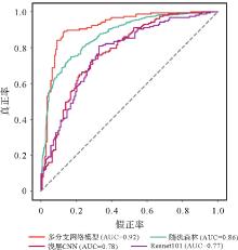
Fig. 9
Test set ROC curve"
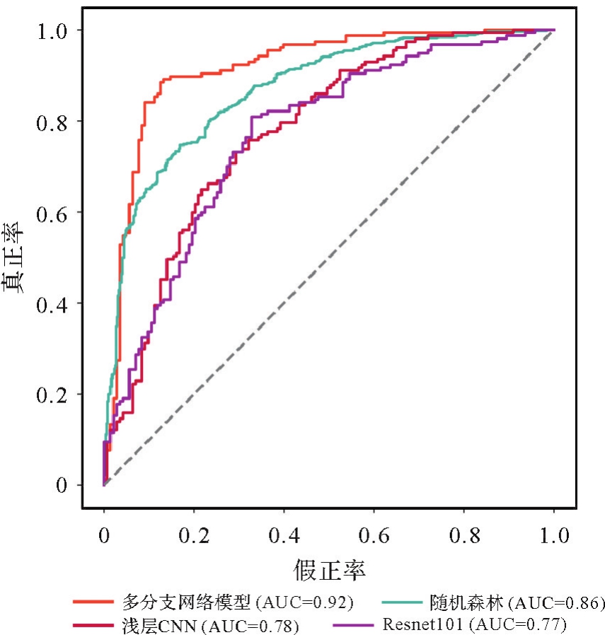
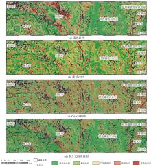
Fig. 10
Landslide susceptibility assessment results"

Tab. 3
Landslide susceptibility classification statistical results"
| 模型 | 易发性等级 | 分级栅格数 | 百分比/(%) | 滑坡点数 | 百分比/(%) | 频率比 |
|---|---|---|---|---|---|---|
| 极低易发区 | 103 224 760 | 33.93 | 29 | 1.70 | 0.05 | |
| 低易发区 | 89 398 692 | 29.38 | 135 | 7.93 | 0.27 | |
| 随机森林 | 中等易发区 | 56 627 969 | 18.61 | 276 | 16.21 | 0.87 |
| 高易发区 | 41 894 540 | 13.77 | 650 | 38.19 | 2.77 | |
| 极高易发区 | 13 109 914 | 4.31 | 612 | 35.96 | 8.34 | |
| 极低易发区 | 23 860 212 | 7.84 | 14 | 0.82 | 0.10 | |
| 低易发区 | 150 562 987 | 49.48 | 320 | 18.80 | 0.38 | |
| 浅层CNN | 中等易发区 | 58 941 341 | 19.37 | 312 | 18.33 | 0.95 |
| 高易发区 | 66 053 031 | 21.70 | 915 | 53.76 | 2.48 | |
| 极高易发区 | 4 838 304 | 4.30 | 141 | 8.28 | 5.21 | |
| 极低易发区 | 77 173 862 | 25.36 | 112 | 6.58 | 0.26 | |
| 低易发区 | 69 152 928 | 22.73 | 158 | 9.28 | 0.41 | |
| ResNet101 | 中等易发区 | 65 258 032 | 21.45 | 347 | 20.39 | 0.96 |
| 高易发区 | 59 334 304 | 19.50 | 598 | 35.14 | 1.80 | |
| 极高易发区 | 33 336 749 | 10.96 | 487 | 28.61 | 2.61 | |
| 极低易发区 | 151 964 854 | 49.94 | 26 | 1.52 | 0.03 | |
| 低易发区 | 47 612 221 | 15.64 | 42 | 2.46 | 0.16 | |
| 多分支网络模型 | 中等易发区 | 58 740 480 | 19.30 | 126 | 7.40 | 0.38 |
| 高易发区 | 33 216 672 | 10.91 | 386 | 22.67 | 2.08 | |
| 极高易发区 | 12 721 648 | 4.18 | 1122 | 65.92 | 15.77 |
Tab. 4
Ablation experimental accuracy evaluation"
| 模型 | 准确度 | 精确度 | 召回率 | F1值 |
|---|---|---|---|---|
| 去除自适应定权机制 | 0.84 | 0.81 | 0.90 | 0.85 |
| 去除伪孪生网络结构 | 0.82 | 0.79 | 0.88 | 0.83 |
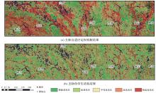
Fig. 11
Results of ablation experiments"

Tab. 5
Results of ablation experiments"
| 模型 | 易发性等级 | 分级栅格数 | 百分比/(%) | 滑坡点数 | 百分比/(%) | 频率比 |
|---|---|---|---|---|---|---|
| 去除自适应定权机制 | 极低易发区 | 78 971 539 | 25.96 | 29 | 1.70 | 0.07 |
| 低易发区 | 61 998 992 | 20.38 | 70 | 4.11 | 0.20 | |
| 中等易发区 | 50 522 720 | 16.61 | 143 | 8.40 | 0.51 | |
| 高易发区 | 46 883 968 | 15.41 | 372 | 21.86 | 1.42 | |
| 极高易发区 | 65 878 656 | 21.65 | 1088 | 63.92 | 2.95 | |
| 去除伪孪生网络结构 | 极低易发区 | 89 695 094 | 29.48 | 135 | 7.93 | 0.27 |
| 低易发区 | 70 354 349 | 23.12 | 200 | 11.75 | 0.51 | |
| 中等易发区 | 62 070 096 | 20.40 | 318 | 18.68 | 0.92 | |
| 高易发区 | 43 871 088 | 14.42 | 419 | 24.62 | 1.71 | |
| 极高易发区 | 38 265 248 | 12.58 | 630 | 37.02 | 2.94 |
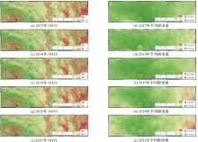
Fig. 12
Five-year spatial distribution annual mean NDVI and annual mean rainfall"

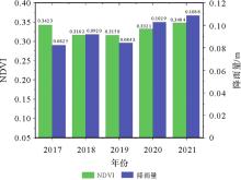
Fig. 13
Annual mean changes in NDVI and rainfall"

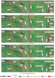
Fig. 14
Landslide susceptibility assessment time series results"

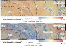
Fig. 15
Variability and difference in landslide susceptibility time-series dynamics"

| [1] | CHEN Cheng, FAN Lei. An attribution deep learning interpretation model for landslide susceptibility mapping in the Three Gorges Reservoir area[J]. IEEE Transactions on Geoscience and Remote Sensing, 2023, 61: 3323668. |
| [2] | ZHANG Rui, LÜ Jichao, YANG Yunjie, et al. Analysis of the impact of terrain factors and data fusion methods on uncertainty in intelligent landslide detection[J]. Landslides, 2024, 21(8): 1849-1864. |
| [3] | LÜ Jichao, ZHANG Rui, SHAMA A, et al. Exploring the spatial patterns of landslide susceptibility assessment using interpretable Shapley method: mechanisms of landslide formation in the Sichuan-Tibet region[J]. Journal of Environmental Management, 2024, 366: 121921. |
| [4] | CHEN Li, MA Peifeng, YU Chang, et al. Landslide susceptibility assessment in multiple urban slope settings with a landslide inventory augmented by InSAR techniques[J]. Engineering Geology, 2023, 327: 107342. |
| [5] | LIU Qiang, TANG Aiping, HUANG Delong. Exploring the uncertainty of landslide susceptibility assessment caused by the number of non-landslides[J]. CATENA, 2023, 227: 107109. |
| [6] | HUANG Wubiao, DING Mingtao, LI Zhenhong, et al. Landslide susceptibility mapping and dynamic response along the Sichuan-Tibet transportation corridor using deep learning algorithms[J]. CATENA, 2023, 222: 106866. |
| [7] | FANG Zhice, WANG Yi, PENG Ling, et al. Integration of convolutional neural network and conventional machine learning classifiers for landslide susceptibility mapping[J]. Computers & Geosciences, 2020, 139: 104470. |
| [8] | VAN BEEK L P H, VAN ASCH T W J. Regional assessment of the effects of land-use change on landslide hazard by means of physically based modelling[J]. Natural Hazards, 2004, 31(1): 289-304. |
| [9] | 姬建, 崔红志, 佟斌, 等. 基于物理过程不确定性的降雨诱发浅层滑坡易发性快速区划:GIS-FORM技术开发与应用[J]. 岩石力学与工程学报, 2024, 43: 838-850. |
| JI Jian, CUI Hongzhi, TONG Bin, et al. Fast zoning of rainfall-induced shallow landslide susceptibility based on physical process uncertainty: development and application of GIS-FORM[J]. Chinese Journal of Rock Mechanics and Engineering, 2024, 43: 838-850. | |
| [10] | KAYASTHA P, DHITAL M R, DE SMEDT F. Application of the analytical hierarchy process (AHP) for landslide susceptibility mapping: a case study from the Tinau watershed, west Nepal[J]. Computers & Geosciences, 2013, 52: 398-408. |
| [11] | HONG Haoyuan, ILIA I, TSANGARATOS P, et al. A hybrid fuzzy weight of evidence method in landslide susceptibility analysis on the Wuyuan area, China[J]. Geomorphology, 2017, 290: 1-16. |
| [12] | LEE S, PRADHAN B. Landslide hazard mapping at Selangor, Malaysia using frequency ratio and logistic regression models[J]. Landslides, 2007, 4(1): 33-41. |
| [13] | 黄发明, 欧阳慰平, 蒋水华, 等. 考虑机器学习建模中训练/测试集时空划分原则的滑坡易发性预测建模[J]. 地球科学, 2024, 49(5): 1607-1618. |
| HUANG Faming, OUYANG Weiping, JIANG Shuihua, et al. Landslide susceptibility prediction considering spatio-temporal division principle of training/testing datasets in machine learning models[J]. Earth Science, 2024, 49(5): 1607-1618. | |
| [14] | 李正, 冷亮, 孙永鑫, 等. 基于信息量-机器学习耦合模型的水电梯级开发流域滑坡易发性评价[J]. 测绘通报, 2024(): 237-241. |
| LI Zheng, LENG Liang, SUN Yongxin, et al. Landslide susceptibility assessment in the river cascade development basin based on the IV-LM coupling model[J]. Bulletin of Surveying and Mapping, 2024(): 237-241. | |
| [15] | YOUSSEF A M, POURGHASEMI H R. Landslide susceptibility mapping using machine learning algorithms and comparison of their performance at Abha basin, Asir region, Saudi Arabia[J]. Geoscience Frontiers, 2021, 12(2): 639-655. |
| [16] | AYALEW L, YAMAGISHI H. The application of GIS-based logistic regression for landslide susceptibility mapping in the Kakuda-Yahiko mountains, central Japan[J]. Geomorphology, 2005, 65(1/2): 15-31. |
| [17] | SUN Deliang, WEN Haijia, WANG Danzhou, et al. A random forest model of landslide susceptibility mapping based on hyperparameter optimization using Bayes algorithm[J]. Geomorphology, 2020, 362: 107201. |
| [18] | SUN Deliang, XU Jiahui, WEN Haijia, et al. Assessment of landslide susceptibility mapping based on Bayesian hyperparameter optimization: a comparison between logistic regression and random forest[J]. Engineering Geology, 2021, 281: 105972. |
| [19] | BADOLA S, MISHRA V N, PARKASH S. Landslide susceptibility mapping using XGBoost machine learning method[C]//Proceedings of 2023 International Conference on Machine Intelligence for GeoAnalytics and Remote Sensing. Hyderabad: IEEE, 2023: 1-4. |
| [20] | KAVZOGLU T, TEKE A. Advanced hyperparameter optimization for improved spatial prediction of shallow landslides using extreme gradient boosting (XGBoost)[J]. Bulletin of Engineering Geology and the Environment, 2022, 81(5): 201. |
| [21] | MARJANOVIĆ M, KOVAČEVIĆ M, BAJAT B, et al. Landslide susceptibility assessment using SVM machine learning algorithm[J]. Engineering Geology, 2011, 123(3): 225-234. |
| [22] | HUANG Yu, ZHAO Lu. Review on landslide susceptibility mapping using support vector machines[J]. CATENA, 2018, 165: 520-529. |
| [23] | LEE S, RYU J H, WON J S, et al. Determination and application of the weights for landslide susceptibility mapping using an artificial neural network[J]. Engineering Geology, 2004, 71(3/4): 289-302. |
| [24] | DI NAPOLI M, CAROTENUTO F, CEVASCO A, et al. Machine learning ensemble modelling as a tool to improve landslide susceptibility mapping reliability[J]. Landslides, 2020, 17(8): 1897-1914. |
| [25] | HUANG Faming, ZHANG Jing, ZHOU Chuangbing, et al. A deep learning algorithm using a fully connected sparse autoencoder neural network for landslide susceptibility prediction[J]. Landslides, 2020, 17(1): 217-229. |
| [26] | YEON Y K, HAN J G, RYU K H. Landslide susceptibility mapping in Injae, Korea, using a decision tree[J]. Engineering Geology, 2010, 116(3/4): 274-283. |
| [27] | PHAM B T, NGUYEN-THOI T, QI Chongchong, et al. Coupling RBF neural network with ensemble learning techniques for landslide susceptibility mapping[J]. CATENA, 2020, 195: 104805. |
| [28] | YI Yaning, ZHANG Zhijie, ZHANG Wanchang, et al. Landslide susceptibility mapping using multiscale sampling strategy and convolutional neural network: a case study in Jiuzhaigou region[J]. CATENA, 2020, 195: 104851. |
| [29] | YANG Xin, LIU Rui, YANG Mei, et al. Incorporating landslide spatial information and correlated features among conditioning factors for landslide susceptibility mapping[J]. Remote Sensing, 2021, 13(11): 2166. |
| [30] | HAKIM W L, REZAIE F, NUR A S, et al. Convolutional neural network (CNN) with metaheuristic optimization algorithms for landslide susceptibility mapping in Icheon, South Korea[J]. Journal of Environmental Management, 2022, 305: 114367. |
| [31] | WANG Yi, FANG Zhice, HONG Haoyuan. Comparison of convolutional neural networks for landslide susceptibility mapping in Yanshan county, China[J]. Science of the Total Environment, 2019, 666: 975-993. |
| [32] | 谭林, 张璐璐, 魏鑫, 等. 基于U-Net语义分割网络的区域滑坡易发性评价方法和跨地区泛化能力研究[J/OL]. 土木工程学报: 1-14[2023-12-12]. https://doi.org/10.15951/j.tmgcxb.23110923. |
| TAN Lin, ZHANG Lulu, WEI Xin, et al. Study on regional landslide susceptibility assessment method based on U-Net semantic segmentation network and its cross-generalization ability[J/OL]. China Civil Engineering Journal: 1-14[2023-12-12]. https://doi.org/10.15951/j.tmgcxb.23110923. | |
| [33] | CHEN Yangyang, MING Dongping, LING Xiao, et al. Landslide susceptibility mapping using feature fusion-based CPCNN-ML in Lantau island, Hong Kong[J]. IEEE Journal of Selected Topics in Applied Earth Observations and Remote Sensing, 2021, 14: 3625-3639. |
| [34] | ASLAM B, ZAFAR A, KHALIL U. Comparative analysis of multiple conventional neural networks for landslide susceptibility mapping[J]. Natural Hazards, 2023, 115(1): 673-707. |
| [35] | GE Yunfeng, LIU Geng, TANG Huiming, et al. Comparative analysis of five convolutional neural networks for landslide susceptibility assessment[J]. Bulletin of Engineering Geology and the Environment, 2023, 82(10): 377. |
| [36] | 金必晶, 曾韬睿, 桂蕾, 等. 考虑未来土地利用动态情景的滑坡易发性制图[J]. 地球信息科学学报, 2024, 26(6): 1486-1499. |
| JIN Bijing, ZENG Taorui, GUI Lei, et al. Mapping the landslide susceptibility considering future land use dynamics scenario[J]. Journal of Geo-Information Science, 2024, 26(6): 1486-1499. | |
| [37] | GAO Binghai, HE Yi, CHEN Xueye, et al. A deep neural network framework for landslide susceptibility mapping by considering time-series rainfall[J]. IEEE Journal of Selected Topics in Applied Earth Observations and Remote Sensing, 2024, 17: 5946-5969. |
| [38] | 林炫歆, 肖桂荣, 周侯伯. 顾及土地利用动态变化的滑坡易发性评估方法[J]. 地球信息科学学报, 2023, 25(5): 953-966. |
| LIN Xuanxin, XIAO Guirong, ZHOU Houbo. Landslide susceptibility assessment method considering land use dynamic change[J]. Journal of Geo-information Science, 2023, 25(5): 953-966. | |
| [39] | HE Yi, ZHAO Zhanao, ZHU Qing, et al. An integrated neural network method for landslide susceptibility assessment based on time-series InSAR deformation dynamic features[J]. International Journal of Digital Earth, 2024, 17(1): 2295408. |
| [40] | 高秉海, 何毅, 张立峰, 等. 顾及InSAR形变的CNN滑坡易发性动态评估:以刘家峡水库区域为例[J]. 岩石力学与工程学报, 2023, 42(2): 450-465. |
| GAO Binghai, HE Yi, ZHANG Lifeng, et al. Dynamic evaluation of landslide susceptibility by CNN considering InSAR deformation: a case study of Liujiaxia reservoir[J]. Chinese Journal of Rock Mechanics and Engineering, 2023, 42(2): 450-465. | |
| [41] | 王启盛, 熊俊楠, 程维明, 等. 耦合统计方法、机器学习模型和聚类算法的滑坡易发性评价方法[J]. 地球信息科学学报, 2024, 26(3): 620-637. |
| WANG Qisheng, XIONG Junnan, CHENG Weiming, et al. Landslide susceptibility mapping methods coupling with statistical methods, machine learning models and clustering algorithms[J]. Journal of Geo-information Science, 2024, 26(3): 620-637. | |
| [42] | 赵占骜, 王继周, 毛曦, 等. 多维CNN耦合的滑坡易发性评价方法[J]. 武汉大学学报(信息科学版), 2024, 49(8): 1466-1481. |
| ZHAO Zhan'ao, WANG Jizhou, MAO Xi, et al. A multi-dimensional CNN coupled landslide susceptibility assessment method[J]. Geomatics and Information Science of Wuhan University, 2024, 49(8): 1466-1481. | |
| [43] | ZHAO Zeyang, CHEN Tao, DOU Jie, et al. Landslide susceptibility mapping considering landslide local-global features based on CNN and Transformer[J]. IEEE Journal of Selected Topics in Applied Earth Observations and Remote Sensing, 2024, 17: 7475-7489. |
| [44] | ALQADHI S, MALLICK J, ALKAHTANI M. Integrated deep learning with explainable artificial intelligence for enhanced landslide management[J]. Natural Hazards, 2024, 120(2): 1343-1365. |
| [45] | YANG Qiyuan, WANG Xianmin, YIN Jing, et al. A novel CGBoost deep learning algorithm for coseismic landslide susceptibility prediction[J]. Geoscience Frontiers, 2024, 15(2): 101770. |
| [46] | 郑德凤, 高敏, 闫成林, 等. 基于卷积神经网络的滑坡易发性评价:以辽南仙人洞国家级自然保护区为例[J]. 地球科学, 2024, 49(5): 1654-1664. |
| ZHENG Defeng, GAO Min, YAN Chenglin, et al. Susceptibility assessment of landslides based on convolutional neural network model: a case study from Xianrendong national nature reserve in southern Liaoning province[J]. Earth Science, 2024, 49(5): 1654-1664. | |
| [47] | FANG Bo, CHEN Gang, PAN Li, et al. GAN-based Siamese framework for landslide inventory mapping using bi-temporal optical remote sensing images[J]. IEEE Geoscience and Remote Sensing Letters, 2021, 18(3): 391-395. |
| [48] | HE Kaiming, ZHANG Xiangyu, REN Shaoqing, et al. Spatial pyramid pooling in deep convolutional networks for visual recognition[J]. IEEE Transactions on Pattern Analysis and Machine Intelligence, 2015, 37(9): 1904-1916. |
| [49] | THI NGO P T, PANAHI M, KHOSRAVI K, et al. Evaluation of deep learning algorithms for national scale landslide susceptibility mapping of Iran[J]. Geoscience Frontiers, 2021, 12(2): 505-519. |
| [50] | GLOROT X, BENGIO Y. Understanding the difficulty of training deep feedforward neural networks[EB/OL]. [2023-12-12]. http://proceedings.mlr.press/v9/glorot10a/glorot10a.pdf. |
| [51] | LOSHCHILOV I, HUTTER F. SGDR: stochastic gradient descent with warm restarts[EB/OL]. [2023-12-12]. https://doi.org/10.48550/arXiv.1608.03983. |
| [52] | 崔鹏, 邹强. 川藏交通廊道山地灾害演化规律与工程风险[M]. 北京: 科学出版社, 2021. |
| CUI Peng, ZOU Qiang. Evolution law and engineering risk of mountain disasters in Sichuan-Tibet traffic corridor[M]. Beijing: Science Press, 2021. | |
| [53] | 甘孜州水利局. 甘孜州2019年水资源公报[R/OL]. [2023-12-12]. https://slj.gzz.gov.cn/tzgs/article/533037. |
| Ganzi State Water Resources Bureau. Ganzi state water resources bulletin 2019[R/OL]. [2023-12-12]. https://slj.gzz.gov.cn/tzgs/article/533037. |
| [1] | Peng LI, Jiahan ZHANG, Zhihan WANG, Houjie WANG, Zhenhong LI. A review of intertidal topography reconstruction methods: current status, challenges and trends [J]. Acta Geodaetica et Cartographica Sinica, 2026, 55(4): 571-587. |
| [2] | Zhi LIU, Shuyuan YANG, Zifan YU, Zhixi FENG, Quanwei GAO, Min WANG. Fast SAR autofocus based on convolutional neural networks [J]. Acta Geodaetica et Cartographica Sinica, 2024, 53(4): 610-619. |
| [3] | LIAO Zhaohong, ZHANG Yichen, YANG Biao, LIN Mingchun, SUN Wenbo, GAO Zhi. Monocular height estimation method of remote sensing image based on Swin Transformer-CNN and its application in highway road construction sites [J]. Acta Geodaetica et Cartographica Sinica, 2024, 53(2): 344-352. |
| [4] | PI Xinyu, ZENG Yongnian, WANG Pancheng. Spatially enhanced spatio-temporal fusion model for heterogeneity regions [J]. Acta Geodaetica et Cartographica Sinica, 2023, 52(10): 1714-1723. |
| [5] | ZHANG Yuxin, YAN Qingsong, DENG Fei. Multi-path RSU network method for high-resolution remote sensing image building extraction [J]. Acta Geodaetica et Cartographica Sinica, 2022, 51(1): 135-144. |
| [6] | GONG Jianya, XU Yue, HU Xiangyun, JIANG Liangcun, ZHANG Mi. Status analysis and research of sample database for intelligent interpretation of remote sensing image [J]. Acta Geodaetica et Cartographica Sinica, 2021, 50(8): 1013-1022. |
| [7] | YANG Qiulian, LIU Yanfei, DING Lele, MENG Fanxiao. High spatial resolution imagery scene classification based on semi-supervised CNNs [J]. Acta Geodaetica et Cartographica Sinica, 2021, 50(7): 930-938. |
| [8] | SHI Huihui, XU Yannan, TENG Wenxiu, WANG Ni. Scene classification of high-resolution remote sensing imagery based on deep transfer deformable convolutional neural networks [J]. Acta Geodaetica et Cartographica Sinica, 2021, 50(5): 652-663. |
| [9] | YE Famao, MENG Xianglong, DONG Meng, Nie Yunju, GE Yun, CHEN Xiaoyong. Remote sensing image retrieval with ant colony optimization and a weighted image-to-class distance [J]. Acta Geodaetica et Cartographica Sinica, 2021, 50(5): 612-620. |
| [10] | ZHANG Yongjun, ZHANG Zuxun, GONG Jianya. Generalized photogrammetry of spaceborne, airborne and terrestrial multi-source remote sensing datasets [J]. Acta Geodaetica et Cartographica Sinica, 2021, 50(1): 1-11. |
| [11] | XIE Zhiwen, WANG Haijun, ZHANG Bin, HUANG Xinxin. Urban expansion cellular automata model based on multi-structures convolutional neural networks [J]. Acta Geodaetica et Cartographica Sinica, 2020, 49(3): 375-385. |
| [12] | YU Donghang, GUO Haitao, ZHANG Baoming, ZHAO Chuan, LU Jun. Aircraft detection in remote sensing images using cascade convolutional neural networks [J]. Acta Geodaetica et Cartographica Sinica, 2019, 48(8): 1046-1058. |
| [13] | HUANG Bo, ZHAO Yongquan. Research Status and Prospect of Spatiotemporal Fusion of Multi-source Satellite Remote Sensing Imagery [J]. Acta Geodaetica et Cartographica Sinica, 2017, 46(10): 1492-1499. |
| [14] | . Multi-source Remote Sensing Image Matching Based on Contourlet-domain Hausdorff Distance and Particle Swarm Optimization [J]. Acta Geodaetica et Cartographica Sinica, 2010, 39(6): 599-604. |
| Viewed | ||||||
|
Full text |
|
|||||
|
Abstract |
|
|||||