

Acta Geodaetica et Cartographica Sinica ›› 2026, Vol. 55 ›› Issue (6): 1031-1046.doi: 10.11947/j.AGCS.2026.20260019
• Geodesy and Navigation • Previous Articles
Zhiwen YANG1,2( ), Lu AN1,2(), Yujie SUN1,2, Jing LI1,2, Zhe ZHOU1,2, Junjie ZHANG1,2, Tong HAO1,2
Received:2026-01-14
Revised:2026-04-25
Published:2026-07-28
Contact:
Lu AN
E-mail:yangzhiwen@tongji.edu.cn;anlu2021@tongji.edu.cn
About author:YANG Zhiwen (1998—), male, PhD candidate, majors in cryosphere remote sensing, ice shelf basal melting and stability, the validation and application of satellite altimetry data. E-mail: yangzhiwen@tongji.edu.cn
Supported by:CLC Number:
Zhiwen YANG, Lu AN, Yujie SUN, Jing LI, Zhe ZHOU, Junjie ZHANG, Tong HAO. High-resolution surface elevation change inversion over Antarctic ice shelf using REMA strips[J]. Acta Geodaetica et Cartographica Sinica, 2026, 55(6): 1031-1046.
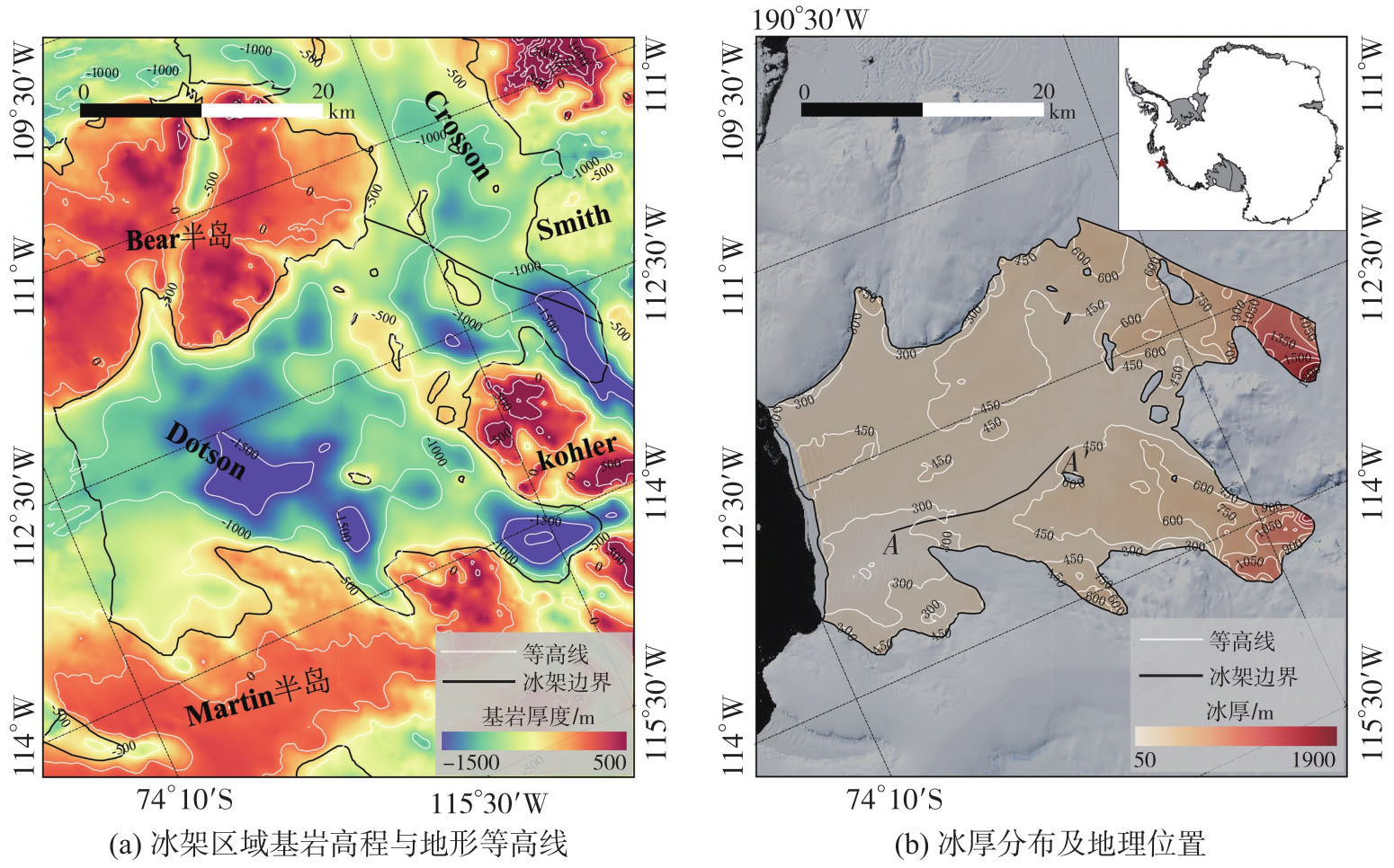
Fig. 1
Geographic location of the Dotson Ice Shelf"

Tab. 1
Annual statistics of REMA strip data availability (2010—2022)"
| 年份 | 条带数量 |
|---|---|
| 2010—2011 | 5 |
| 2011—2012 | 0 |
| 2012—2013 | 8 |
| 2013—2014 | 27 |
| 2014—2015 | 11 |
| 2015—2016 | 17 |
| 2016—2017 | 20 |
| 2017—2018 | 33 |
| 2018—2019 | 12 |
| 2019—2020 | 15 |
| 2020—2021 | 8 |
| 2021—2022 | 10 |
| 总计 | 166 |
Fig. 2
Spatio-temporal distribution sequence of surface elevation of the Dotson ice shelf (2010—2022)"
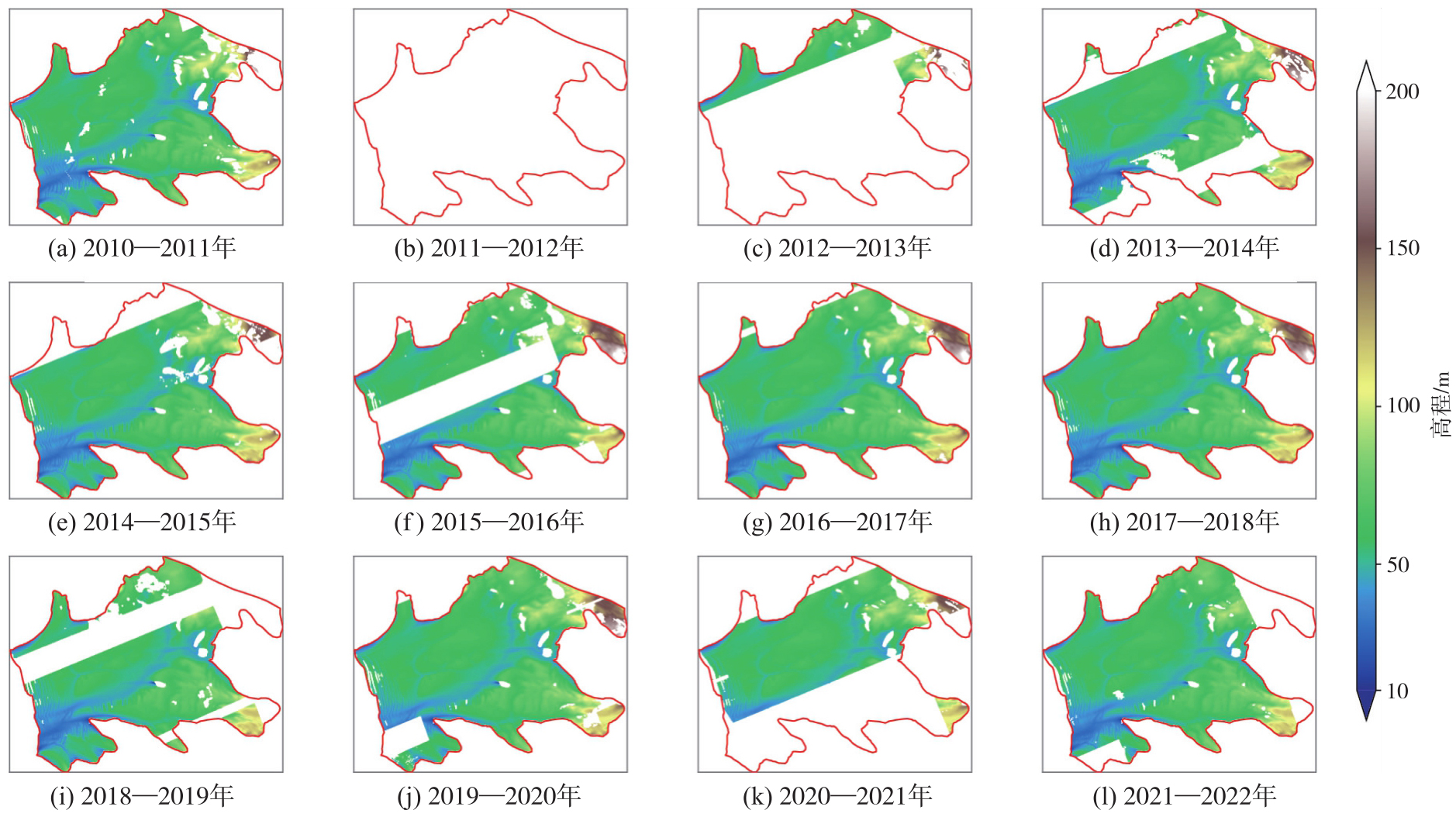
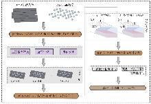
Fig. 3
Joint correction and retrieval workflow for REMA data"
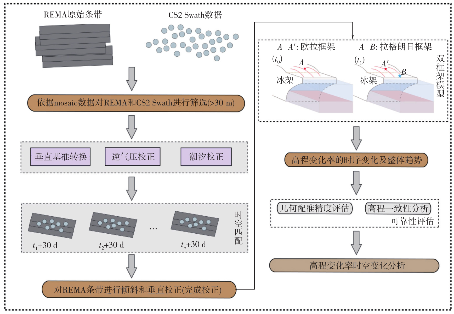
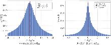
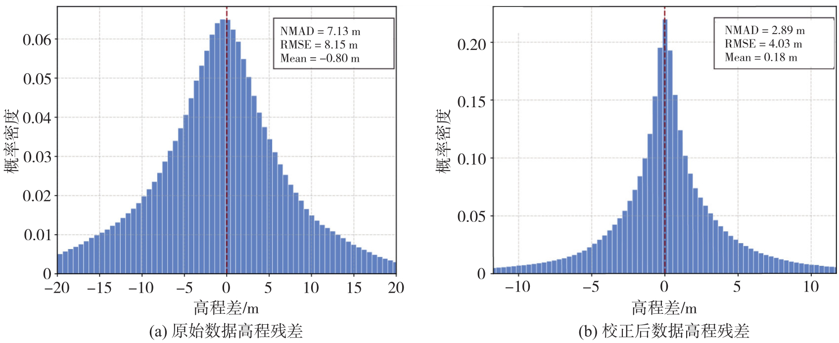
Fig. 4
Height residual distribution in overlapping areas before and after registration"
Tab. 2
Elevation differences in overlapping areas before and after registration"
| 数据 | mean/m | RMSE/m | NMAD/m | NMAD改善率/(%) |
|---|---|---|---|---|
| 原始数据 | -0.80 | 8.15 | 7.13 | - |
| 校正后数据 | 0.18 | 4.03 | 2.89 | 59.5 |
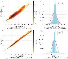
Fig. 5
External accuracy comparison of REMA elevations against ICESat-2 ATL06 data"
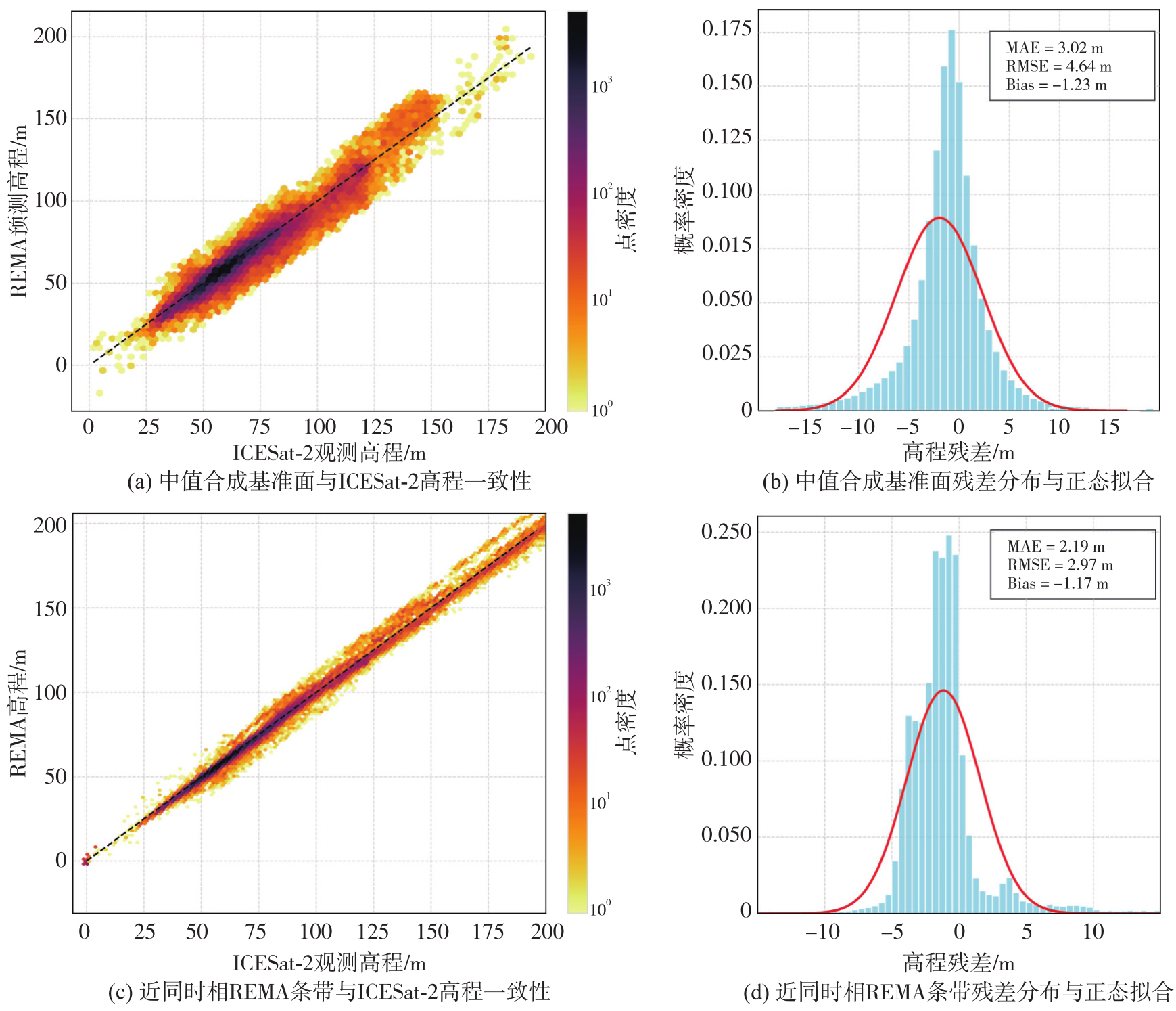
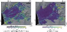
Fig. 6
Spatial distribution of uncertainty in the retrieved surface elevation change rates over the Dotson ice shelf (2010—2022)"
Fig. 7
Resolution sensitivity and spatial uncertainty of Lagrangian back-tracking along DIC profile"
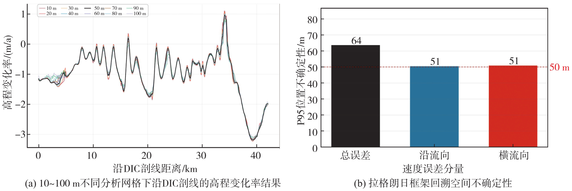
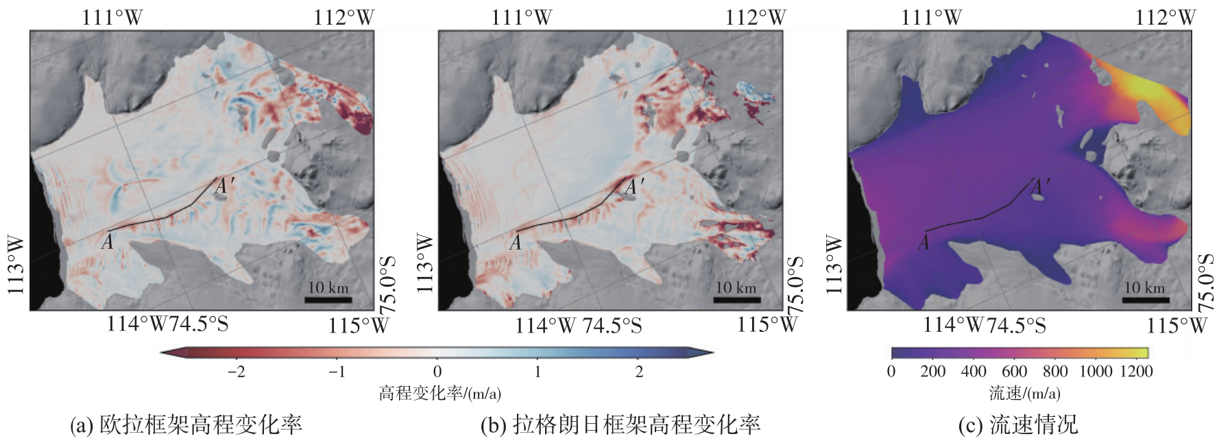
Fig. 8
Elevation change rates under different reference frameworks (2010—2022)"
Tab. 3
Comparison of fitting residuals for elevation change rates between Eulerian and Lagrangian frameworks"
| 统计区域 | 统计指标 | 欧拉框架/m | 拉格朗日框架/m | 差异/m | 指标降幅/(%) |
|---|---|---|---|---|---|
| 全冰架范围 | 均值 | 1.23 | 0.86 | 0.37 | 30.1 |
| 中位数 | 0.71 | 0.44 | 0.27 | 38.0 | |
| 中位数绝对偏差 | 0.62 | 0.30 | 0.32 | 51.6 | |
| 标准差 | 1.29 | 1.19 | 0.10 | 7.8 | |
| 融化通道沿线 | 均值 | 1.50 | 0.86 | 0.64 | 42.7 |
| 中位数 | 1.21 | 0.80 | 0.41 | 33.9 | |
| 中位数绝对偏差 | 0.88 | 0.35 | 0.51 | 60.2 | |
| 标准差 | 0.96 | 0.41 | 0.55 | 57.3 |
Tab. 4
Characteristics of surface elevation change rate of Dotson Ice Shelf and quantitative comparison of classification spatial patterns (2010—2022)"
| 框架 | 全场统计特征 | 空间格局分布 | |||
|---|---|---|---|---|---|
| 平均变化率/(m/a) | 最大变薄率/(m/a) | 强变薄区(<-1.0 m/a) | 中度变薄区([-1.0,-0.5)m/a) | 稳定区(≥-0.5 m/a) | |
| 欧拉框架 | -0.08±0.62 | -14.29 | 5.5%(312.4 km2) | 8.2%(466.7 km2) | 86.3%(4 914.6 km2) |
| 拉格朗日框架 | -0.22±1.01 | -14.99 | 9.2%(506.1 km2) | 9.0%(491.4 km2) | 81.8%(4 484.4 km2) |
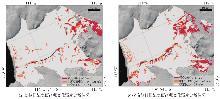
Fig. 9
Spatial grading of ice shelf surface elevation change intensity"

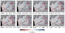
Fig. 10
Spatio-temporal distribution of DIS surface elevation change rates"
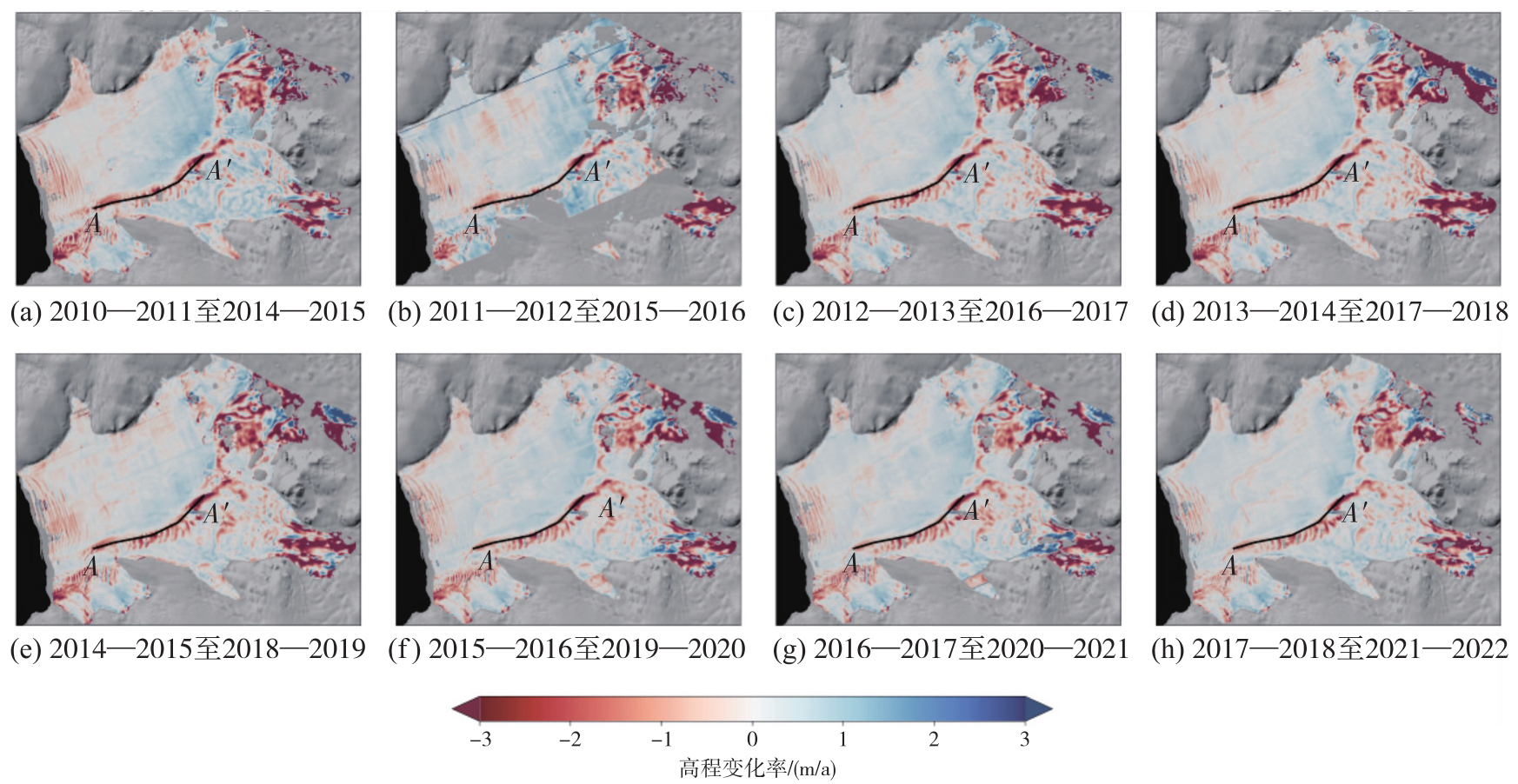
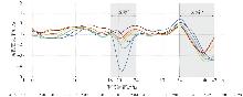
Fig. 11
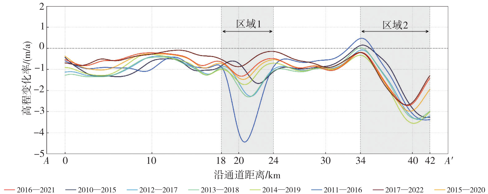
Surface elevation changes along the A-A′melt channel profile"
Tab. 5
Spatio-temporal evolution of elevation change rates for the Dotson Ice Shelf and its melt channel (2010—2022)"
| 观测时段 | 冰架全域 | 通道剖线均值 | 区域1 | 区域2 |
|---|---|---|---|---|
| 2010—2011至2014—2015 | -0.22±1.34 | -1.04±0.84 | -1.05±0.75 | -1.50±1.45 |
| 2011—2012至2015—2016 | -0.16±1.63 | -1.18±1.50 | -2.72±2.72 | -1.64±1.59 |
| 2012—2013至2016—2017 | -0.18±1.16 | -1.19±0.92 | -1.56±0.90 | -1.94±1.39 |
| 2013—2014至2017—2018 | -0.33±1.46 | -1.22±0.93 | -1.70±0.79 | -1.96±1.41 |
| 2014—2015至2018—2019 | -0.29±1.34 | -1.17±0.92 | -1.26±0.68 | -2.25±1.33 |
| 2015—2016至2019—2020 | -0.19±1.27 | -0.97±0.80 | -1.02±0.62 | -1.90±1.13 |
| 2016—2017至2020—2021 | -0.15±1.22 | -0.87±0.74 | -0.88±0.60 | -1.71±1.06 |
| 2017—2018至2021—2022 | -0.14±1.09 | -0.73±0.75 | -0.54±0.42 | -1.74±1.04 |
| [1] | DAVISON B J, HOGG A E, RIGBY R, et al. Sea level rise from West Antarctic mass loss significantly modified by large snowfall anomalies[J]. Nature Communications, 2023, 14: 1479. |
| [2] | DECONTO R M, POLLARD D, ALLEY R B, et al. The Paris Climate Agreement and future sea-level rise from Antarctica[J]. Nature, 2021, 593(7857): 83-89. |
| [3] | 沈云中, 王微. 西南极冰盖2002—2023年冰川尺度的点质量模型解算与分析[J]. 武汉大学学报(信息科学版), 2024, 49(11): 2051-2060. |
| SHEN Yunzhong, WANG Wei. Solution and analysis of glacier scale point-mass modeling for the west Antarctic ice sheet from 2002 to 2023[J]. Geomatics and Information Science of Wuhan University, 2024, 49(11): 2051-2060. | |
| [4] | SELLEY H L, HOGG A E, DAVISON B J, et al. Speed-up, slowdown, and redirection of ice flow on neighbouring ice streams in the Pope, Smith, and Kohler region of West Antarctica[J]. The Cryosphere, 2025, 19(5): 1725-1738. |
| [5] | DE RYDT J, NAUGHTEN K. Geometric amplification and suppression of ice-shelf basal melt in West Antarctica[J]. The Cryosphere, 2024, 18(4): 1863-1888. |
| [6] | ZINCK A P, WOUTERS B, LAMBERT E, et al. Unveiling spatial variability within the Dotson Melt Channel through high-resolution basal melt rates from the Reference Elevation Model of Antarctica[J]. The Cryosphere, 2023, 17(9): 3785-3801. |
| [7] | ZINCK A P, LHERMITTE S, WEARING M G, et al. Channelized melt beneath Antarctic ice shelves previously underestimated[J]. Nature Climate Change, 2026, 16(3): 350-353. |
| [8] | GOURMELEN N, GOLDBERG D N, SNOW K, et al. Channelized melting drives thinning under a rapidly melting Antarctic ice shelf[J]. Geophysical Research Letters, 2017, 44(19): 9796-9804. |
| [9] | WÅHLIN A, ALLEY K E, BEGEMAN C, et al. Swirls and scoops: ice base melt revealed by multibeam imagery of an Antarctic ice shelf[J]. Science Advances, 2024, 10(31): eadn9188. |
| [10] | ZHANG Baojun, WANG Zemin, AN Jiachun, et al. A 30-year monthly 5 km gridded surface elevation time series for the Greenland Ice Sheet from multiple satellite radar altimeters[J]. Earth System Science Data, 2022, 14(2): 973-989. |
| [11] | ALLEY K E, WILD C T, LUCKMAN A, et al. Two decades of dynamic change and progressive destabilization on the Thwaites Eastern Ice Shelf[J]. The Cryosphere, 2021, 15(11): 5187-5203. |
| [12] |
李斐, 宋国云, 杨元德, 等. 南极Dome A地区高精度DEM的建立:顾及波形重定、坡度改正及数据融合[J]. 测绘学报, 2017, 46(4): 403-410. DOI: .
doi: 10.11947/j.AGCS.2017.20160486 |
|
LI Fei, SONG Guoyun, YANG Yuande, et al. Establishment of high precision DEM in Antarctic dome a area with taking the waveform retracking, slope correction and the data fusion into account[J]. Acta Geodaetica et Cartographica Sinica, 2017, 46(4): 403-410. DOI: .
doi: 10.11947/j.AGCS.2017.20160486 |
|
| [13] | 肖峰, 李斐, 张胜凯, 等. 利用CryoSat-2波形数据建立南极Lambert冰川流域DEM[J]. 地球物理学报, 2020, 63(8): 2893-2900. |
| XIAO Feng, LI Fei, ZHANG Shengkai, et al. DEM generation for the Lambert Glacier-Amery Ice Shelf system, East Antarctica, from CryoSat-2 waveform data[J]. Chinese Journal of Geophysics, 2020, 63(8): 2893-2900. | |
| [14] | YUE Lianzhe, CHAO Nengfang, CHEN Gang, et al. Reconstructing continuous ice sheet elevation changes in the Amundsen Sea sector during 2003-2021 by merging envisat, ICESat, CryoSat-2, and ICESat-2multi-altimeter observations[J]. Journal of Geophysical Research: Earth Surface, 2023, 128(5): e2022JF007020. |
| [15] |
单杰, 田祥希, 李爽, 等. 星载激光测高技术进展[J]. 测绘学报, 2022, 51(6): 964-982. DOI: .
doi: 10.11947/j.AGCS.2022.20220174 |
|
SHAN Jie, TIAN Xiangxi, LI Shuang, et al. Advances of spaceborne laser altimetry technology[J]. Acta Geodaetica et Cartographica Sinica, 2022, 51(6): 964-982. DOI: .
doi: 10.11947/j.AGCS.2022.20220174 |
|
| [16] | HOWAT I, PORTER C, NOH M J, et al. The reference elevation model of Antarctica-strips, Version 4.1[EB/OL]. [2026-03-25]. https://doi.org/10.7910/DVN/X7NDNY. |
| [17] | DONG Yuting, ZHAO Ji, LI Caiyong, et al. Gapless-REMA100: a gapless 100-m reference elevation model of Antarctica with voids filled by multi-source DEMs[J]. ISPRS Journal of Photogrammetry and Remote Sensing, 2022, 186: 70-82. |
| [18] | NUTH C, KÄÄB A. Co-registration and bias corrections of satellite elevation data sets for quantifying glacier thickness change[J]. The Cryosphere, 2011, 5(1): 271-290. |
| [19] | FROMM T, SCHLINDWEIN V, HELM V, et al. Observing tidal effects on the dynamics of the Ekströ m Ice Shelf with focus on quarterdiurnal and terdiurnal periods[J]. Journal of Glaciology, 2023, 69(277): 1138-1148. |
| [20] | MOSBEUX C, PADMAN L, KLEIN E, et al. Seasonal variability in Antarctic ice shelf velocities forced by sea surface height variations[J]. The Cryosphere, 2023, 17(7): 2585-2606. |
| [21] | PAOLO F S, GARDNER A S, GREENE C A, et al. Widespread slowdown in thinning rates of West Antarctic ice shelves[J]. The Cryosphere, 2023, 17(8): 3409-3433. |
| [22] | BERTHIER E, LEBRETON J, FONTANNAZ D, et al. The Pléiades Glacier Observatory: high-resolution digital elevation models and ortho-imagery to monitor glacier change[J]. The Cryosphere, 2024, 18(12): 5551-5571. |
| [23] | DONG Yuting, ZHAO Ji, FLORICIOIU D, et al. High-resolution topography of the Antarctic Peninsula combining the TanDEM-X DEM and reference elevation model of Antarctica (REMA) mosaic[J]. The Cryosphere, 2021, 15(9): 4421-4443. |
| [24] | HUTH A, DUDDU R, SMITH B. A generalized interpolation material point method for shallow ice shelves.2: anisotropic nonlocal damage mechanics and rift propagation[J]. Journal of Advances in Modeling Earth Systems, 2021, 13(8): e2020MS002292. |
| [25] | CHARTRAND A M, HOWAT I M, JOUGHIN I R, et al. Thwaites Glacier thins and retreats fastest where ice-shelf channels intersect its grounding zone[J]. The Cryosphere, 2024, 18(11): 4971-4992. |
| [26] | MOHOLDT G, PADMAN L, FRICKER H A. Basal mass budget of Ross and Filchner-Ronne ice shelves, Antarctica, derived from Lagrangian analysis of ICESat altimetry[J]. Journal of Geophysical Research: Earth Surface, 2014, 119(11): 2361-2380. |
| [27] | SHEAN D E, JOUGHIN I R, DUTRIEUX P, et al. Ice shelf basal melt rates from a high-resolution digital elevation model (DEM) record for Pine Island Glacier, Antarctica[J]. The Cryosphere, 2019, 13(10): 2633-2656. |
| [28] | ARNEBORG L, WÅHLIN A K, BJÖRK G, et al. Persistent inflow of warm water onto the central Amundsen shelf[J]. Nature Geoscience, 2012, 5(12): 876-880. |
| [29] | MORLIGHEM M, WILLIAMS C N, RIGNOT E, et al. BedMachine v3: complete bed topography and ocean bathymetry mapping of Greenland from multibeam echo sounding combined with mass conservation[J]. Geophysical Research Letters, 2017, 44(21): 11051-11061. |
| [30] | GOURMELEN N, ESCORIHUELA M J, SHEPHERD A, et al. CryoSat-2 swath interferometric altimetry for mapping ice elevation and elevation change[J]. Advances in Space Research, 2018, 62(6): 1226-1242. |
| [31] | GARDNER A S, MOHOLDT G, SCAMBOS T, et al. Increased West Antarctic and unchanged East Antarctic ice discharge over the last 7 years[J]. The Cryosphere, 2018, 12(2): 521-547. |
| [32] | GARDNER A, FAHNESTOCK M, SCAMBOS T. MEaSUREs ITS_LIVE Regional Glacier and ice sheet surface velocities, Version 1[EB/OL]. [2026-03-25]. https://doi.org/10.5067/6II6VW8LLWJ7. |
| [33] | PAVLIS N K, HOLMES S A, KENYON S C, et al. The development and evaluation of the Earth gravitational model 2008 (EGM2008)[J]. Journal of Geophysical Research: Solid Earth, 2012, 117(B4): 2011JB008916. |
| [34] | ANDERSEN O B, STENSENG L, PICCIONI G, et al. The DTU15 MSS and DTU15LAT reference surface[C]//Proceedings of 2016 ESA Living Planet Symposium. Prague: [s.n.], 2016. |
| [35] | HOWARD S L, GREENE C A, PADMAN L, et al.. CATS2008_v2023: circum-antarctic tidal simulation 2008, Version 2023[EB/OL]. [2026-03-25]. https://www.usap-dc.org/view/dataset/601772. |
| [36] | HERSBACH H, BELL B, BERRISFORD P, et al. The ERA5 global reanalysis[J]. Quarterly Journal of the Royal Meteorological Society, 2020, 146(730): 1999-2049. |
| [37] | YANG H W, KIM T W, DUTRIEUX P, et al. Seasonal variability of ocean circulation near the Dotson Ice Shelf, Antarctica[J]. Nature Communications, 2022, 13: 1138. |
| [38] | HAI Gang, CHENG Yuan, XIE Huan, et al. Assessment of CryoSat-2 baseline-D height product by GNSS and ICESat-2 in lambert-amery system, east Antarctica[J]. IEEE Journal of Selected Topics in Applied Earth Observations and Remote Sensing, 2022, 15: 2891-2900. |
| [39] | NILSSON J, GARDNER A, SANDBERG SØRENSEN L, et al. Improved retrieval of land ice topography from CryoSat-2 data and its impact for volume-change estimation of the Greenland Ice Sheet[J]. The Cryosphere, 2016, 10(6): 2953-2969. |
| [40] | ADUSUMILLI S, FRICKER H A, MEDLEY B, et al. Interannual variations in meltwater input to the Southern Ocean from Antarctic ice shelves[J]. Nature Geoscience, 2020, 13(9): 616-620. |
| [1] | ZONG Jingwen, LI Houpu, BIAN Shaofeng, TANG Qinghui. Symbolic expressions of differences between earth radius [J]. Acta Geodaetica et Cartographica Sinica, 2019, 48(2): 238-244. |
| [2] | NIE Zhixi, WANG Zhenjie, OU Jikun, JI Shengyue. On the Effect of Linearization and Approximation of Nonlinear Baseline Length Constraint for Ambiguity Resolution [J]. Acta Geodaetica et Cartographica Sinica, 2015, 44(2): 168-173. |
| [3] | . Universal Sub-pixel Edge Detection Algorithm Base on Extremal Gradient [J]. Acta Geodaetica et Cartographica Sinica, 2014, 43(5): 500-507. |
| [4] | Shaofeng Bian. Symbolic Expressions of Difference Extrema Between Regular Latitudes [J]. Acta Geodaetica et Cartographica Sinica, 2014, 43(2): 214-220. |
| [5] | . Application of Chinese Remainder Theorem in Phase Unwrapping for Dual-Baseline InSAR [J]. Acta Geodaetica et Cartographica Sinica, 2011, 40(6): 770-777. |
| Viewed | ||||||
|
Full text |
|
|||||
|
Abstract |
|
|||||
