

Acta Geodaetica et Cartographica Sinica ›› 2025, Vol. 54 ›› Issue (5): 950-962.doi: 10.11947/j.AGCS.2025.20240130
• Cartography and Geoinformation • Previous Articles Next Articles
Fengwei JIAO( ), Longgang XIANG(), Yuanyuan DENG, Xin CHEN, Huayi WU
Received:2024-04-07
Revised:2024-12-02
Online:2025-06-23
Published:2025-06-23
Contact:
Longgang XIANG
E-mail:fwjiao@whu.edu.cn;geoxlg@whu.edu.cn
About author:JIAO Fengwei (1997—), female, PhD candidate, majors in spatio-temporal data mining and road information extraction. E-mail: fwjiao@whu.edu.cn
Supported by:CLC Number:
Fengwei JIAO, Longgang XIANG, Yuanyuan DENG, Xin CHEN, Huayi WU. Constructing grade-separated junctions based on combination of local and long-term trajectory feature[J]. Acta Geodaetica et Cartographica Sinica, 2025, 54(5): 950-962.
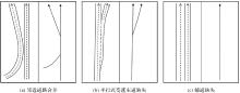
Fig. 1
Challenges in the existing interchange road network construction methods"
Fig. 2
Framework of the proposed method"

Fig. 3
Interchange road network model and its 3D spatial structure"

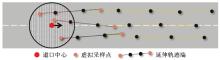
Fig. 4
Intersections between the extended trajectory end and the entrance circular space"
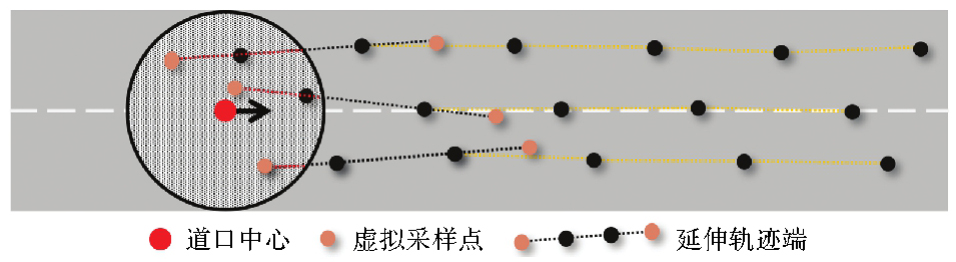

Fig. 5
Binarization results of trajectory clusters with different densities"
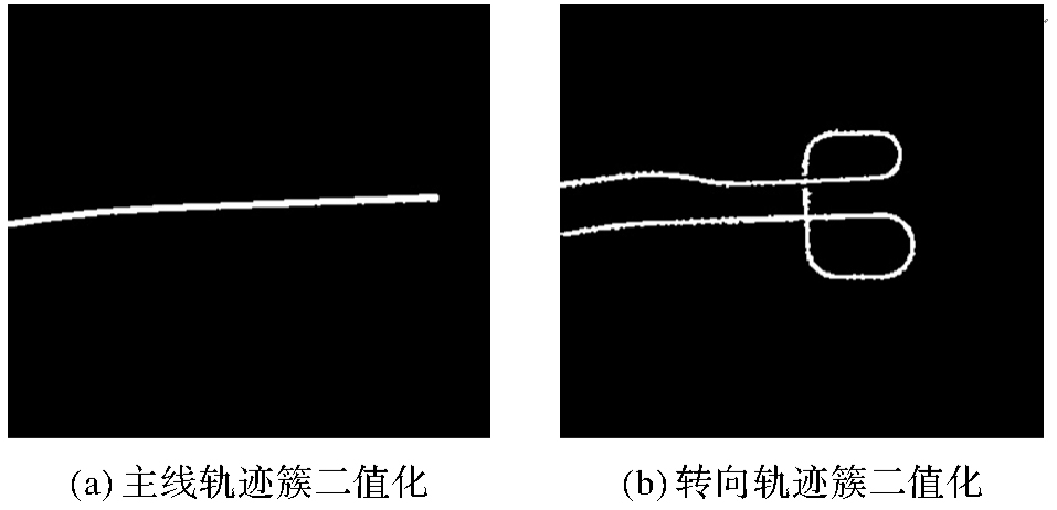
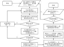
Fig. 6
Flowchart of tracing central lines"

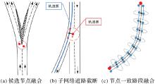
Fig. 7
Road subnetwork integration method"
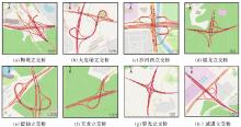
Fig. 8
Results from interchange road network construction"

Tab. 1
Accuracy evaluation of the results of the proposed method"
| 立交桥 | 精确度 | 召回率 | GEO-F1值 | TOPO-F1值 |
|---|---|---|---|---|
| 梅观立交 | 95.93 | 88.88 | 92.27 | 93.32 |
| 大发埔立交 | 98.08 | 92.04 | 94.97 | 94.59 |
| 沙河西立交 | 97.30 | 94.42 | 95.84 | 96.33 |
| 福龙立交 | 95.83 | 87.50 | 91.47 | 91.53 |
| 留仙立交 | 96.89 | 94.72 | 95.79 | 96.16 |
| 玉龙立交 | 92.79 | 94.30 | 93.54 | 93.97 |
| 黎光立交 | 93.20 | 98.68 | 95.86 | 96.17 |
| 诚进立交 | 95.74 | 96.84 | 96.29 | 96.93 |
Tab. 2
Comparison of experimental results"
| 方法 | 沙河西立交 | 梅观立交 | 大发埔立交 | 留仙立交 | ||||||||||||
|---|---|---|---|---|---|---|---|---|---|---|---|---|---|---|---|---|
| 精确率 | 召回率 | GEO-F1值 | TOPO-F1值 | 精确率 | 召回率 | GEO-F1值 | TOPO-F1值 | 精确率 | 召回率 | GEO-F1值 | TOPO-F1值 | 精确率 | 召回率 | GEO-F1值 | TOPO-F1值 | |
| Kharita | 11.74 | 87.34 | 20.71 | 20.49 | 12.10 | 83.87 | 21.15 | 21.27 | 12.47 | 89.47 | 21.90 | 21.29 | 17.82 | 86.84 | 29.57 | 29.72 |
| RoadRunner | 92.35 | 90.57 | 91.45 | 91.51 | 95.76 | 80.84 | 87.67 | 88.91 | 89.59 | 92.22 | 90.89 | 91.87 | 94.62 | 94.14 | 94.38 | 93.85 |
| TrackFusion | 94.22 | 88.72 | 91.39 | 91.63 | 90.96 | 68.45 | 78.12 | 79.17 | 97.86 | 87.79 | 92.55 | 92.42 | 95.89 | 86.18 | 90.78 | 90.37 |
| 本文方法 | 97.30 | 94.42 | 95.84 | 96.33 | 95.93 | 88.88 | 92.27 | 93.32 | 98.08 | 92.04 | 94.97 | 94.59 | 96.89 | 94.72 | 95.79 | 96.16 |
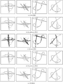
Fig. 9
Ground truths and results of interchanges by different methods"
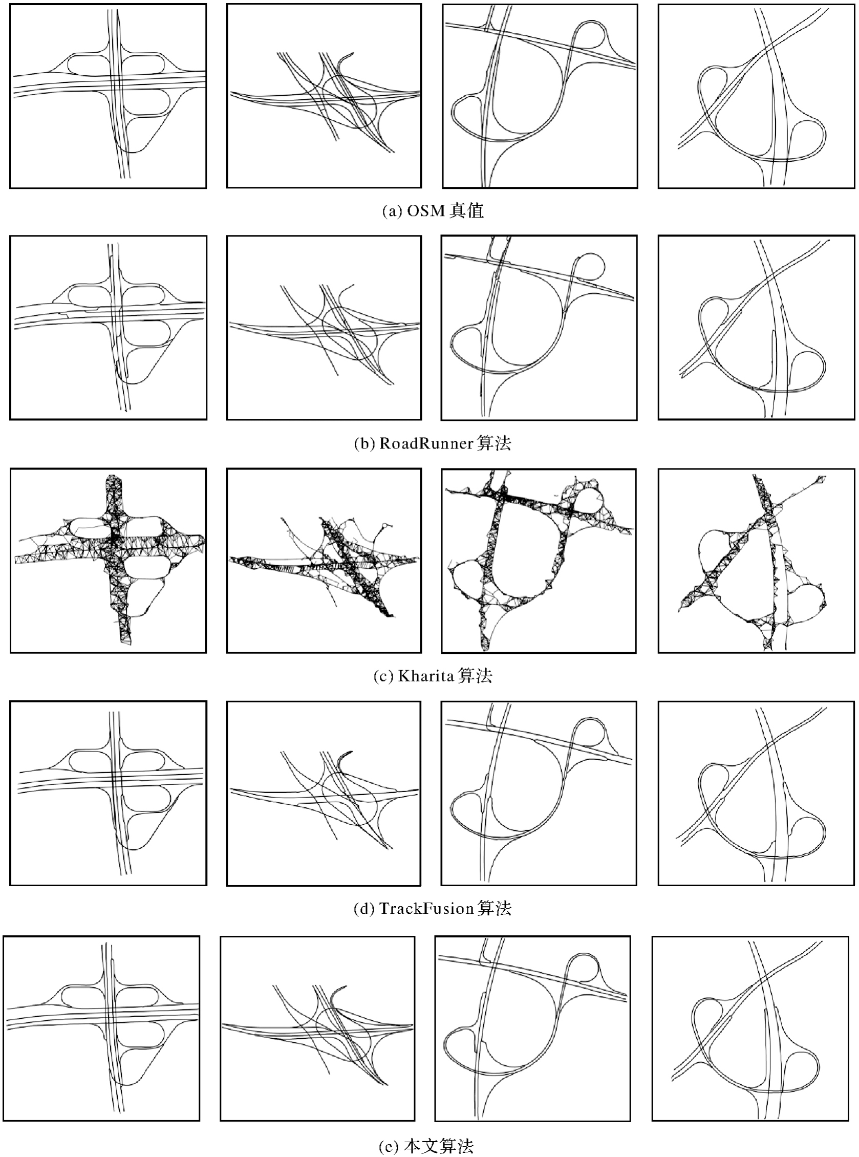
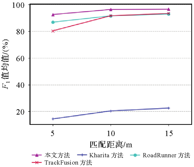
Fig. 10
TOPO-F1 score at different matching distances of different methods"
| [1] | 房瑞伟. 基于模糊层次分析的滨水城市快速路规划评价研究[D]. 武汉: 武汉理工大学, 2018. |
| FANG Ruiwei. Research on evaluation of expressway planning in waterfront city based on fuzzy AHP[D]. Wuhan: Wuhan University of Technology, 2018. | |
| [2] | 白杰. 多源传感器信息融合的车辆立交桥通行状态识别方法研究[D]. 深圳: 深圳大学, 2019. |
| BAI Jie. Research on vehicle postures recognition method based on multi-source sensor information fusion at the overpass[D]. Shenzhen: Shenzhen University, 2019. | |
| [3] | 宋惠娟. 高速公路与关联城市快速路匝道控制方法研究[D]. 北京: 北京交通大学, 2009. |
| SONG Huijuan. Study on ramp metering method of freeway and related urban expressway[D]. Beijing: Beijing Jiaotong University, 2009. | |
| [4] | GU Xin, ABDEL-ATY M, XIANG Qiaojun, et al. Utilizing UAV video data for in-depth analysis of drivers' crash risk at interchange merging areas[J]. Accident Analysis & Prevention, 2019, 123: 159-169. |
| [5] | JALAYER M, ZHOU Huaguo, ZHANG Beijia. Evaluation of navigation performances of GPS devices near interchange area pertaining to wrong-way driving[J]. Journal of Traffic and Transportation Engineering (English Edition), 2016, 3(6): 593-601. |
| [6] |
邓敏, 罗斌, 唐建波, 等. 顾及轨迹密度分布异质性的道路交叉口提取方法[J]. 测绘学报, 2023, 52(6): 1000-1009. DOI .
doi: 10.11947/j.AGCS.2023.20210173 |
|
DENG Min, LUO Bin, TANG Jianbo, et al. Extracting road intersections from vehicle trajectory data in the face of trace density disparity[J]. Acta Geodaetica et Cartographica Sinica, 2023, 52(6): 1000-1009. DOI .
doi: 10.11947/j.AGCS.2023.20210173 |
|
| [7] |
李雅丽, 向隆刚, 张彩丽, 等. 车辆轨迹与遥感影像多层次融合的道路交叉口识别[J]. 测绘学报, 2021, 50(11): 1546-1557. DOI .
doi: 10.11947/j.AGCS.2021.20210255 |
|
LI Yali, XIANG Longgang, ZHANG Caili, et al. Road intersection recognition based on a multi-level fusion of vehicle trajectory and remote sensing image[J]. Acta Geodaetica et Cartographica Sinica, 2021, 50(11): 1546-1557. DOI .
doi: 10.11947/j.AGCS.2021.20210255 |
|
| [8] |
方志祥, 仲浩宇, 邹欣妍. 轨迹延续性与影像特征相似性结合的城市道路提取[J]. 测绘学报, 2020, 49(12): 1554-1563. DOI .
doi: 10.11947/j.AGCS.2020.20190366 |
|
FANG Zhixiang, ZHONG Haoyu, ZOU Xinyan. Extracting urban road area based on combination of trajectory continuity and image feature similarity[J]. Acta Geodaetica et Cartographica Sinica, 2020, 49(12): 1554-1563. DOI .
doi: 10.11947/j.AGCS.2020.20190366 |
|
| [9] | DENG Min, HUANG Jincai, ZHANG Yunfei, et al. Generating urban road intersection models from low-frequency GPS trajectory data[J]. International Journal of Geographical Information Science, 2018, 32(12): 2337-2361. |
| [10] |
万子健, 李连营, 杨敏, 等. 车辆轨迹数据提取道路交叉口特征的决策树模型[J]. 测绘学报, 2019, 48(11): 1391-1403. DOI .
doi: 10.11947/j.AGCS.2019.20190011 |
|
WAN Zijian, LI Lianying, YANG Min, et al. Decision tree model for extracting road intersection feature from vehicle trajectory data[J]. Acta Geodaetica et Cartographica Sinica, 2019, 48(11): 1391-1403. DOI .
doi: 10.11947/j.AGCS.2019.20190011 |
|
| [11] | 唐炉亮, 阚子涵, 黄方贞, 等. 利用低频时空GPS轨迹进行交叉口通行时间探测[J]. 武汉大学学报(信息科学版), 2016, 41(1): 136-142. |
| TANG Luliang, KAN Zihan, HUANG Fangzhen, et al. Travel time detection at intersections from taxis' trace data[J]. Geomatics and Information Science of Wuhan University, 2016, 41(1): 136-142. | |
| [12] | HU Jiuxiang, RAZDAN A, FEMIANI J C, et al. Road network extraction and intersection detection from aerial images by tracking road footprints[J]. IEEE Transactions on Geoscience and Remote Sensing, 2007, 45(12): 4144-4157. |
| [13] | ZHANG Jinming, HU Xiangyun, WEI Yujun, et al. Road topology extraction from satellite imagery by joint learning of nodes and their connectivity[J]. IEEE Transactions on Geoscience and Remote Sensing, 2023, 61: 5602613. |
| [14] | ZHU Qiqi, ZHANG Yanan, WANG Lizeng, et al. A global context-aware and batch-independent network for road extraction from VHR satellite imagery[J]. ISPRS Journal of Photogrammetry and Remote Sensing, 2021, 175: 353-365. |
| [15] | HE Hao, WANG Shuyang, WANG Shicheng, et al. A road extraction method for remote sensing image based on encoder-decoder network[J]. Journal of Geodesy and Geoinformation Science, 2020, 3(2): 16-25. |
| [16] | REN Chang, TANG Luliang, YANG Xue, et al. Mapping grade-separated junctions in detail using crowdsourced trajectory data[J]. IEEE Transactions on Intelligent Transportation Systems, 2022, 23(6): 5552-5561. |
| [17] | YANG Xue, YANG Mingchun, CAO Yanjia, et al. Three-dimensional structure determination of grade-separated road intersections from crowdsourced trajectories[J]. International Journal of Applied Earth Observation and Geoinformation, 2023, 125: 103598. |
| [18] | STANOJEVIC R, ABBAR S, THIRUMURUGANATHAN S, et al. Robust road map inference through network alignment of trajectories[C]//Proceedings of 2018 SIAM International Conference on Data Mining. Philadelphia: Society for Industrial and Applied Mathematics, 2018: 135-143. |
| [19] | TANG Jianbo, DENG Min, HUANG Jincai, et al. A novel method for road intersection construction from vehicle trajectory data[J]. IEEE Access, 2019, 7: 95065-95074. |
| [20] | CAO Lili, KRUMM J. From GPS traces to a routable road map[C]//Proceedings of the 17th International Conference on Advances in Geographic Information Systems. Seattle: ACM Press, 2009: 3-12. |
| [21] | HE Songtao, BASTANI F, ABBAR S, et al. RoadRunner: improving the precision of road network inference from GPS trajectories[C]//Proceedings of the 26th ACM SIGSPATIAL International Conference on Advances in Geographic Information Systems. Seattle: ACM Press, 2018: 3-12. |
| [22] |
邬群勇, 吴祖飞, 张良盼. 出租车GPS轨迹集聚和精细化路网提取[J]. 测绘学报, 2019, 48(4): 502-511. DOI .
doi: 10.11947/j.AGCS.2019.20180256 |
|
WU Qunyong, WU Zufei, ZHANG Liangpan. GPS trajectory agglomeration and refined road network extraction[J]. Acta Geodaetica et Cartographica Sinica, 2019, 48(4): 502-511. DOI .
doi: 10.11947/j.AGCS.2019.20180256 |
|
| [23] | WANG Jing, RUI Xiaoping, SONG Xianfeng, et al. A novel approach for generating routable road maps from vehicle GPS traces[J]. International Journal of Geographical Information Science, 2015, 29(1): 69-91. |
| [24] | 邓媛媛, 向隆刚, 焦凤伟. 基于正逆向追踪与融合的立交桥结构提取[J/OL]. 地球信息科学学报. [2024-06-20]. https://kns.cnki.net/kcms/detail/11.5809.P.20240327.1334.002.html. |
| DENG Yuanyuan, XIANG Longgang, JIAO Fengwei. Extraction of overpass structure based on forward and backward tracking and fusion of crowdsourced trajectory[J/OL]. Journal of Geo-information Science. [2024-06-20]. https://kns.cnki.net/kcms/detail/11.5809.P.20240327.1334.002.html. | |
| [25] |
张彩丽, 向隆刚, 李雅丽, 等. 基于出租车轨迹的可导航路网构建[J]. 测绘学报, 2021, 50(12): 1650-1662. DOI .
doi: 10.11947/j.AGCS.2021.20200470 |
|
ZHANG Caili, XIANG Longgang, LI Yali, et al. Construction of navigable road network based on taxi trajectories[J]. Acta Geodaetica et Cartographica Sinica, 2021, 50(12): 1650-1662. DOI .
doi: 10.11947/j.AGCS.2021.20200470 |
|
| [26] | 岳昊, 张旭. 城市交通设计[M]. 2版. 北京: 北京交通大学出版社, 2023. |
| YUE Hao, ZHANG Xu. Urban traffic design[M]. 2nd ed. Beijing: Beijing Jiaotong University Press, 2023. | |
| [27] | 王序哲. 局部自适应二值化方法研究[J]. 软件导刊, 2011, 10(11): 13-14. |
| WANG Xuzhe. Research on local adaptive binarization method[J]. Software Guide, 2011, 10(11): 13-14. | |
| [28] | 孙家驷. 道路立交规划与设计[M]. 北京: 人民交通出版社, 2009: 135-136. |
| SUN Jiasi. Planning and design of road interchange[M]. Beijing: China Communications Press, 2009: 135-136. | |
| [29] | 李健, 曹垚, 王宗敏, 等. 融合k-means聚类和Hausdorff距离的散乱点云精简算法[J]. 武汉大学学报(信息科学版), 2020, 45(2): 250-257. |
| LI Jian, CAO Yao, WANG Zongmin, et al. Scattered point cloud simplification algorithm integrating k-means clustering and Hausdorff distance[J]. Geomatics and Information Science of Wuhan University, 2020, 45(2): 250-257. | |
| [30] | BIAGIONI J, ERIKSSON J. Inferring road maps from global positioning system traces[J]. Transportation Research Record: Journal of the Transportation Research Board, 2012, 2291(1): 61-71. |
| [1] | Jianbo TANG, Zhiyuan HU, Ju PENG, Heyan XIA, Junjie DING, Yuyu ZHANG, Xiaoming MEI. A road intersection recognition method in crowdsourced trajectory data by fusing visual features and motion features [J]. Acta Geodaetica et Cartographica Sinica, 2025, 54(1): 182-193. |
| [2] | FANG Zhixiang, ZHONG Haoyu, ZOU Xinyan. Extracting urban road area based on combination of trajectory continuity and image feature similarity [J]. Acta Geodaetica et Cartographica Sinica, 2020, 49(12): 1554-1563. |
| [3] | LIU Jiping, ZHANG Yongchuan, XU Shenghua, QIAN Xinlin, QIU Agen, ZHANG Fuhao. An incremental construction method of road network considering road complexity [J]. Acta Geodaetica et Cartographica Sinica, 2019, 48(4): 480-488. |
| Viewed | ||||||
|
Full text |
|
|||||
|
Abstract |
|
|||||