

Acta Geodaetica et Cartographica Sinica ›› 2025, Vol. 54 ›› Issue (1): 182-193.doi: 10.11947/j.AGCS.2025.20240101
• Cartography and Geoinformation • Previous Articles Next Articles
Jianbo TANG1,2( ), Zhiyuan HU1, Ju PENG1(), Heyan XIA1, Junjie DING1, Yuyu ZHANG1, Xiaoming MEI1
Received:2024-03-14
Revised:2024-12-12
Online:2025-02-17
Published:2025-02-17
Contact:
Ju PENG
E-mail:jianbo.tang@csu.edu.cn;daisy_pj@csu.edu.cn
About author:TANG Jianbo (1987—), male, PhD, associate professor, majors in spatio-temporal big data mining and analysis. E-mail: jianbo.tang@csu.edu.cn
Supported by:CLC Number:
Jianbo TANG, Zhiyuan HU, Ju PENG, Heyan XIA, Junjie DING, Yuyu ZHANG, Xiaoming MEI. A road intersection recognition method in crowdsourced trajectory data by fusing visual features and motion features[J]. Acta Geodaetica et Cartographica Sinica, 2025, 54(1): 182-193.
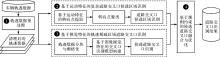
Fig. 1
The framework of road intersection extraction method based on visual features and motion features"
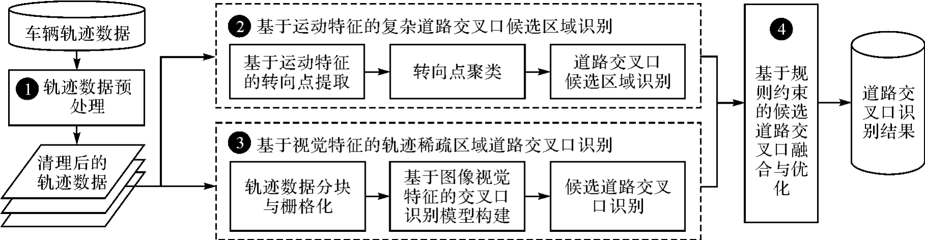
Fig. 2
Trajectory data cleaning and rasterization"
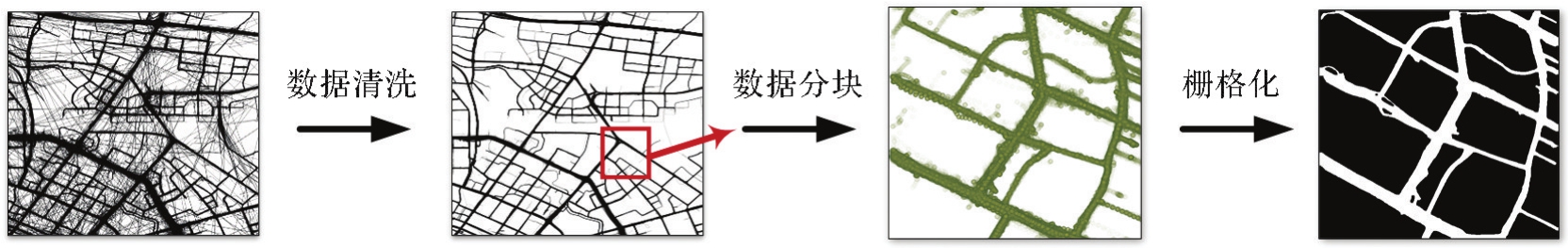
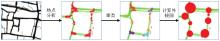
Fig. 3
Candidate area identification for road intersections"
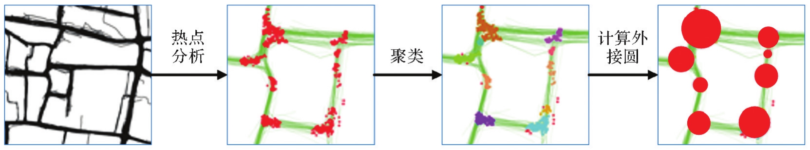

Fig. 4
Road intersection recognition model based on visual features"
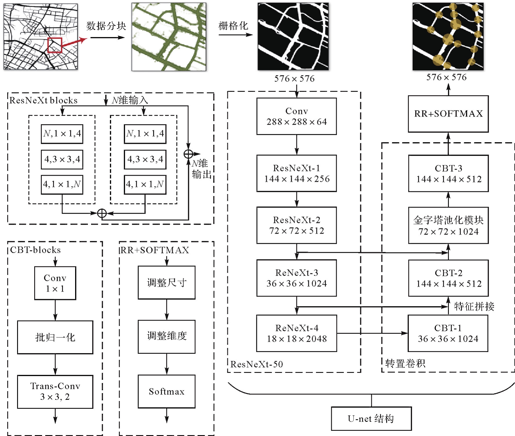
Fig. 5
Illustration of the fusion strategy of different road intersections"
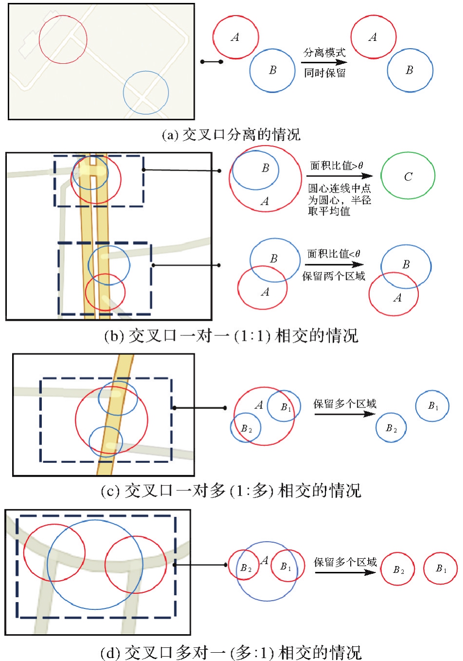
Fig. 6
Study area and trajectory datasets for evaluation"
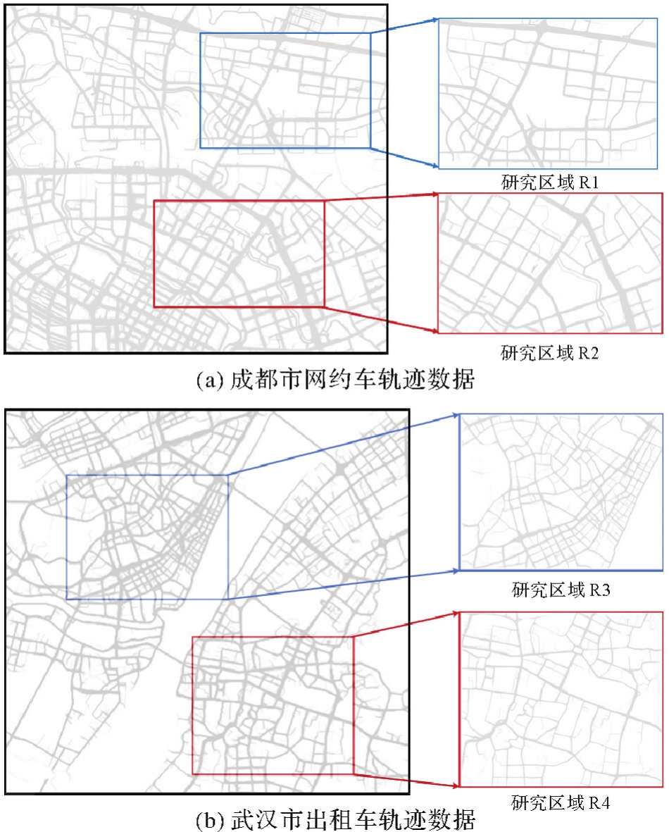
Fig. 7
Results of road intersections using the visual-features method"
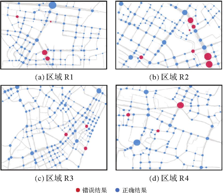
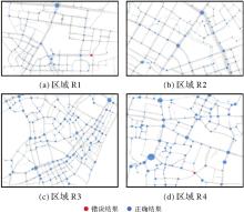
Fig. 8
Results of road intersections using the motion features method"
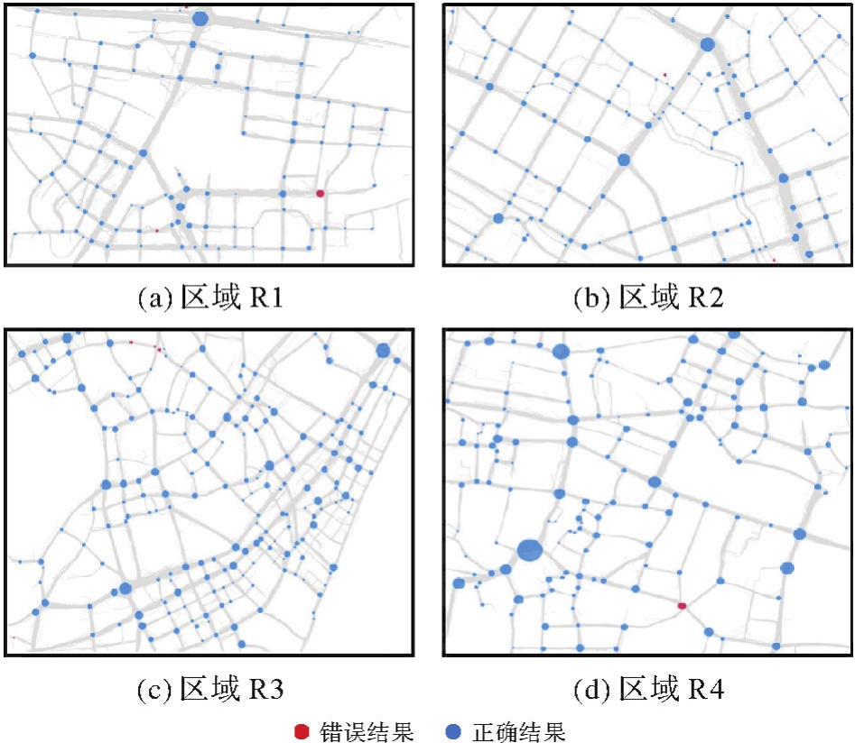
Fig. 9
Results of road intersections fusing visual-based and movement-aware"

Tab. 1
Accuracy evaluation of intersection identification results"
| 研究区 | 指标 | 基于视觉特征的识别方法[ | 基于转向角权重的均值漂移聚类方法[ | 基于运动特征的识别方法[ | 密度峰值聚类与数学形态学融合的方法[ | 转向点对聚类方法[ | VM-UNet[ | 本文方法 |
|---|---|---|---|---|---|---|---|---|
| R1 | 精确度/(%) | 96.43 | 70.87 | 97.27 | 71.05 | 78.85 | 73.44 | 98.44 |
| 召回率/(%) | 82.44 | 55.73 | 81.68 | 61.83 | 62.60 | 71.76 | 96.18 | |
| F1值 | 0.888 9 | 0.623 9 | 0.888 0 | 0.661 2 | 0.697 9 | 0.725 9 | 0.973 0 | |
| R2 | 精确度/(%) | 94.12 | 71.54 | 97.58 | 70.21 | 77.17 | 80.83 | 96.67 |
| 召回率/(%) | 75.17 | 59.06 | 81.21 | 66.44 | 65.77 | 65.10 | 97.32 | |
| F1值 | 0.835 8 | 0.647 1 | 0.886 4 | 0.682 8 | 0.710 1 | 0.721 2 | 0.969 9 | |
| R3 | 精确度/(%) | 96.88 | 72.52 | 97.04 | 79.51 | 75.11 | 75.59 | 97.12 |
| 召回率/(%) | 64.05 | 78.51 | 81.40 | 67.36 | 68.60 | 79.34 | 97.52 | |
| F1值 | 0.771 1 | 0.754 0 | 0.885 4 | 0.729 3 | 0.717 1 | 0.774 2 | 0.973 2 | |
| R4 | 精确度/(%) | 96.36 | 73.53 | 97.40 | 76.16 | 80.67 | 71.05 | 98.20 |
| 召回率/(%) | 63.10 | 74.40 | 89.29 | 68.45 | 72.02 | 80.36 | 97.62 | |
| F1值 | 0.762 6 | 0.739 6 | 0.931 7 | 0.721 0 | 0.761 0 | 0.754 2 | 0.979 1 |
Tab. 2
Runing time of different intersection recognition methods"
| 方法 | R1识别用时 | R2识别用时 | R3识别用时 | R4识别用时 |
|---|---|---|---|---|
| 基于视觉特征的识别方法[ | 29.81 | 49.63 | 30.87 | 33.09 |
| 基于转向角权重的均值漂移聚类方法[ | 3 186.18 | 12 183.47 | 1 966.00 | 1 921.70 |
| 基于运动特征的识别方法[ | 324.34 | 1 300.60 | 105.06 | 131.26 |
| 密度峰值聚类与数学形态学融合的识别方法[ | 348.24 | 740.25 | 80.20 | 81.65 |
| 转向点对聚类方法[ | 1 359.30 | 2 512.02 | 700.07 | 737.13 |
| VM-U Net[ | 31.72 | 51.52 | 33.28 | 35.79 |
| 本文方法 | 355.77 | 1 351.90 | 136.24 | 164.57 |
Tab. 3
Intersection fusion threshold analysis on study area R4"
| 阈值 | 10% | 20% | 30% | 40% | 50% | 60% | 70% | 80% | 90% | 95% |
|---|---|---|---|---|---|---|---|---|---|---|
| 精确度/(%) | 96.97 | 96.97 | 98.20 | 98.20 | 98.20 | 98.20 | 98.20 | 98.20 | 98.20 | 98.20 |
| 召回率/(%) | 95.24 | 95.24 | 97.62 | 97.62 | 97.62 | 97.62 | 97.62 | 97.62 | 97.62 | 97.62 |
| F1值 | 0.961 0 | 0.961 0 | 0.979 1 | 0.979 1 | 0.979 1 | 0.979 1 | 0.979 1 | 0.979 1 | 0.979 1 | 0.979 1 |
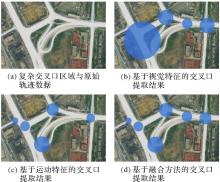
Fig. 10
Complex intersection area extraction results"

| [1] | CHEN Ziyi, DENG Liai, LUO Yuhua, et al. Road extraction in remote sensing data: a survey[J]. International Journal of Applied Earth Observation and Geoinformation, 2022, 112: 102833. |
| [2] | 王建伟, 高超, 董是, 等. 道路基础设施数字化研究进展与展望[J]. 中国公路学报, 2020, 33(11): 101-124. |
| WANG Jianwei, GAO Chao, DONG Shi, et al. Current status and future prospects of existing research on digitalization of highway infrastructure[J]. China Journal of Highway and Transport, 2020, 33(11): 101-124. | |
| [3] |
刘经南, 詹骄, 郭迟, 等. 智能高精地图数据逻辑结构与关键技术[J]. 测绘学报, 2019, 48(8): 939-953. DOI:.
doi: 10.11947/j.AGCS.2019.20190125 |
|
LIU Jingnan, ZHAN Jiao, GUO Chi, et al. Data logic structure and key technologies on intelligent high-precision map[J]. Acta Geodaetica et Cartographica Sinica, 2019, 48(8): 939-953. DOI:.
doi: 10.11947/j.AGCS.2019.20190125 |
|
| [4] |
吴华意, 黄蕊, 游兰, 等. 出租车轨迹数据挖掘进展[J]. 测绘学报, 2019, 48(11): 1341-1356. DOI:.
doi: 10.11947/j.AGCS.2019.20190210 |
|
WU Huayi, HUANG Rui, YOU Lan, et al. Recent progress in taxi trajectory data mining[J]. Acta Geodaetica et Cartographica Sinica, 2019, 48(11): 1341-1356. DOI:.
doi: 10.11947/j.AGCS.2019.20190210 |
|
| [5] |
唐炉亮, 牛乐, 杨雪, 等. 利用轨迹大数据进行城市道路交叉口识别及结构提取[J]. 测绘学报, 2017, 46(6): 770-779. DOI:.
doi: 10.11947/j.AGCS.2017.20160614 |
|
TANG Luliang, NIU Le, YANG Xue, et al. Urban intersection recognition and construction based on big trace data[J]. Acta Geodaetica et Cartographica Sinica, 2017, 46(6): 770-779. DOI:.
doi: 10.11947/j.AGCS.2017.20160614 |
|
| [6] | GONG Jianya, JI Shunping. Photogrammetry and deep learning[J]. Journal of Geodesy and Geoinformation Science, 2018, 1(1): 1-15. |
| [7] | HE Hao, WANG Shuyang, WANG Shicheng, et al. A road extraction method for remote sensing image based on encoder-decoder network[J]. Journal of Geodesy and Geoinformation Science, 2020, 3(2): 16-25. |
| [8] | 邵小美, 张春亢, 韦永昱, 等. 改进YOLOv3算法的遥感图像道路交叉口自动识别[J]. 航天返回与遥感, 2022, 43(5): 123-132. |
| SHAO Xiaomei, ZHANG Chunkang, WEI Yongyu, et al. Improved YOLOv3 algorithm for remote sensing image road automatic intersection identification[J]. Spacecraft Recovery & Remote Sensing, 2022, 43(5): 123-132. | |
| [9] | TANG Jianbo, DENG Min, HUANG Jincai, et al. An automatic method for detection and update of additive changes in road network with GPS trajectory data[J]. ISPRS International Journal of Geo-Information, 2019, 8(9): 411. |
| [10] |
唐炉亮, 刘章, 杨雪, 等. 符合认知规律的时空轨迹融合与路网生成方法[J]. 测绘学报, 2015(11): 1271-1276. DOI:.
doi: 10.11947/j.AGCS.2015.20140591 |
|
TANG Luliang, LIU Zhang, YANG Xue, et al. A method of spatio-temporal trajectory fusion and road network generation based on cognitive law[J]. Acta Geodaetica et Cartographica Sinica, 2015(11): 1271-1276. DOI:.
doi: 10.11947/j.AGCS.2015.20140591 |
|
| [11] | WANG Jing, RUI Xiaoping, SONG Xianfeng, et al. A novel approach for generating routable road maps from vehicle GPS traces[J]. International Journal of Geographical Information Science, 2015, 29(1): 69-91. |
| [12] | LI Yali, XIANG Longgang, ZHANG Caili, et al. A guided deep learning approach for joint road extraction and intersection detection from RS images and taxi trajectories[J]. IEEE Journal of Selected Topics in Applied Earth Observations and Remote Sensing, 2021, 14: 8008-8018. |
| [13] | CHEN Xin, XIANG Longgang, JIAO Fengwei, et al. Detecting turning relationships and time restrictions of OSM road intersections from crowdsourced trajectories[J]. ISPRS International Journal of Geo-Information, 2023, 12(9): 372. |
| [14] | 陈伟亮, 杜久升. 一种利用低频轨迹数据提取道路交叉口的方法[J]. 测绘通报, 2023(1): 127-133. |
| CHEN Weiliang, DU Jiusheng. A method of extracting road intersections using low frequency trajectory data[J]. Bulletin of Surveying and Mapping, 2023(1): 127-133. | |
| [15] | 孟秋宇, 宋子昂, 王金, 等. 利用浮动车GPS轨迹识别与提取城市道路交叉口[J]. 测绘通报, 2021(9): 59-63. |
| MENG Qiuyu, SONG Ziang, WANG Jin, et al. Detection and extraction of urban road intersections using GPS trajectories of floating vehicles[J]. Bulletin of Surveying and Mapping, 2021(9): 59-63. | |
| [16] | EZZAT M, SAKR M, ELGOHARY R, et al. Building road segments and detecting turns from GPS tracks[J]. Journal of Computational Science, 2018, 29: 81-93. |
| [17] | DENG Min, HUANG Jincai, ZHANG Yunfei, et al. Generating urban road intersection models from low-frequency GPS trajectory data[J]. International Journal of Geographical Information Science, 2018, 32(12): 2337-2361. |
| [18] | LIU Yizhi, QING Rutian, ZHAO Yijiang, et al. Road intersection recognition via combining classification model and clustering algorithm based on GPS data[J]. ISPRS International Journal of Geo-Information, 2022, 11(9): 487. |
| [19] | DAVIES J J, BERESFORD A R, HOPPER A. Scalable, distributed, real-time map generation[J]. IEEE Pervasive Computing, 2006, 5(4): 47-54. |
| [20] | BIAGIONI J, ERIKSSON J. Map inference in the face of noise and disparity[C]//Proceedings of the 20th International Conference on Advances in Geographic Information Systems. New York: ACM Press, 2012: 79-88. |
| [21] | KUNTZSCH C, SESTER M, BRENNER C. Generative models for road network reconstruction[J]. International Journal of Geographical Information Science, 2016, 30(5): 1012-1039. |
| [22] | MARIESCU-ISTODOR R, FRÄNTI P. CellNet: inferring road networks from GPS trajectories[J]. ACM Transactions on Spatial Algorithms and Systems, 2018, 4(3): 1-22. |
| [23] | ZHANG Ju, HU Qingwu, LI Jiayuan, et al. Learning from GPS trajectories of floating car for CNN-based urban road extraction with high-resolution satellite imagery[J]. IEEE Transactions on Geoscience and Remote Sensing, 2021, 59(3): 1836-1847. |
| [24] | YIN Yifang, SUNDERRAJAN A, HUANG Xiaocheng, et al. Multi-scale graph convolutional network for intersection detection from GPS trajectories[C]//Proceedings of the 3rd ACM SIGSPATIAL International Workshop on AI for Geographic Knowledge Discovery. Chicago: ACM Press, 2019: 36-39. |
| [25] |
邓敏, 罗斌, 唐建波, 等. 顾及轨迹密度分布异质性的道路交叉口提取方法[J]. 测绘学报, 2023, 52(6): 1000-1009. DOI:.
doi: 10.11947/j.AGCS.2023.20210173 |
|
DENG Min, LUO Bin, TANG Jianbo, et al. Extracting road intersections from vehicle trajectory data in the face of trace density disparity[J]. Acta Geodaetica et Cartographica Sinica, 2023, 52(6): 1000-1009. DOI:.
doi: 10.11947/j.AGCS.2023.20210173 |
|
| [26] | ERRAMALINE A, BADARD T, CÔTÉ M P, et al. Identification of road network intersection types from vehicle telemetry data using a convolutional neural network[J]. ISPRS International Journal of Geo-Information, 2022, 11(9): 475. |
| [27] | 李思宇, 向隆刚, 张彩丽, 等. 基于低频出租车轨迹的城市路网交叉口提取研究[J]. 地球信息科学学报, 2019, 21(12): 1845-1854. |
| LI Siyu, XIANG Longgang, ZHANG Caili, et al. Extraction of urban road network intersections based on low-frequency taxi trajectory data[J]. Journal of Geo-information Science, 2019, 21(12): 1845-1854. | |
| [28] |
李雅丽, 向隆刚, 张彩丽, 等. 车辆轨迹与遥感影像多层次融合的道路交叉口识别[J]. 测绘学报, 2021, 50(11): 1546-1557. DOI:.
doi: 10.11947/j.AGCS.2021.20210255 |
|
LI Yali, XIANG Longgang, ZHANG Caili, et al. Road intersection recognition based on a multi-level fusion of vehicle trajectory and remote sensing image[J]. Acta Geodaetica et Cartographica Sinica, 2021, 50(11): 1546-1557. DOI:.
doi: 10.11947/j.AGCS.2021.20210255 |
|
| [29] | GETIS A, ORD J K. The analysis of spatial association by use of distance statistics[J]. Geographical Analysis, 1992, 24(3): 189-206. |
| [30] | DENG Min, LIU Qiliang, CHENG Tao, et al. An adaptive spatial clustering algorithm based on delaunay triangulation[J]. Computers, Environment and Urban Systems, 2011, 35(4): 320-332. |
| [31] | XIE Saining, GIRSHICK R, DOLLAR P, et al. Aggregated residual transformations for deep neural networks[C]//Proceedings of 2017 IEEE Conference on Computer Vision and Pattern Recognition. Honolulu: IEEE, 2017: 1492-1500. |
| [32] | RONNEBERGER O, FISCHER P, BROX T. U-Net: convolutional networks for biomedical image segmentation[C]//Proceedings of 2015 Medical Image Computing and Computer-Assisted Intervention. Cham: Springer, 2015: 234-241. |
| [33] | FRAENKEL A, BAR-HILLEL Y, LEVY A. Foundations of set theory[M]. [S.l.]: Elsevier, 1973: 15-153. |
| [34] | FREMLIN D. Measure theory[M]. Torres England: Fremlin, 2000: 9-34. |
| [35] | LYU Haiyang, PFOSER D, SHENG Yehua. Movement-aware map construction[J]. International Journal of Geographical Information Science, 2021, 35(6): 1065-1093. |
| [36] | RUAN Jiacheng, XIANG Suncheng. VM-UNet: vision mamba UNet for medical image segmentation[EB/OL]. [2024-02-04]. https://arxiv.org/pdf/2402.02491. |
| [1] | Wenjun HUANG, Qun SUN, Qing XU, Long FAN, Anzhu YU, Fubing ZHANG. A global coastal DEM super-resolution reconstruction method integrating frequency-domain features and topographic priors [J]. Acta Geodaetica et Cartographica Sinica, 2025, 54(8): 1518-1531. |
| [2] | Jie WAN, Zhong XIE, Yongyang XU, Liufeng TAO. A U-shaped graph convolution network method for semantic segmentation of vehicle LiDAR point clouds towards urban road scenes [J]. Acta Geodaetica et Cartographica Sinica, 2025, 54(7): 1280-1293. |
| [3] | Yiming ZHAO, Kelin HU, Kelong TU, Yaxian QING, Chao YANG, Kunlun QI, Huayi WU. Multi-label scene classification method based on fusion of SAR and optical remote sensing images [J]. Acta Geodaetica et Cartographica Sinica, 2025, 54(5): 911-923. |
| [4] | Fengwei JIAO, Longgang XIANG, Yuanyuan DENG, Xin CHEN, Huayi WU. Constructing grade-separated junctions based on combination of local and long-term trajectory feature [J]. Acta Geodaetica et Cartographica Sinica, 2025, 54(5): 950-962. |
| [5] | Yungang CAO, Peng YANG, Jiangbo GONG, Gao ZHU, Xingyu SHEN. A road extraction method integrating spatial-relation enhancement and heterogeneous feature fusion [J]. Acta Geodaetica et Cartographica Sinica, 2025, 54(12): 2219-2232. |
| [6] | Liangxiong GONG, Xinghua LI, Yuanming CHENG, Xingyou ZHAO, Renping XIE, Honggen WANG. A lightweight remote sensing images change detection network utilizing spatio-temporal difference enhancement and adaptive feature fusion [J]. Acta Geodaetica et Cartographica Sinica, 2025, 54(1): 136-153. |
| [7] | Fubing ZHANG, Qun SUN, Jingzhen MA, Shijie SUN, Bowei WEN. An intelligent classification method for building shape based on fusion of global and local features [J]. Acta Geodaetica et Cartographica Sinica, 2024, 53(9): 1842-1852. |
| [8] | Xin YAN, Li SHEN, Junjie PAN, Yanshuai DAI, Jicheng WANG, Xiaoli ZHENG, Zhi-lin LI. Weakly supervised building change detection integrating multi-scale feature fusion and spatial refinement for high resolution remote sensing images [J]. Acta Geodaetica et Cartographica Sinica, 2024, 53(8): 1586-1597. |
| [9] | Tao XU, Yuanwei YANG, Xianjun GAO, Zhiwei WANG, Yue PAN, Shaohua LI, Lei XU, Yanjun WANG, Bo LIU, Jing YU, Fengmin WU, Haoyu SUN. Integrated graph convolution and multi-scale features for the overhead catenary system point cloud semantic segmentation [J]. Acta Geodaetica et Cartographica Sinica, 2024, 53(8): 1624-1633. |
| [10] | ZHANG Caili, XIANG Longgang, LI Yali, GAO Songfeng, PAN Chuanjiao. Road section navigation attribute mining [J]. Acta Geodaetica et Cartographica Sinica, 2024, 53(2): 367-378. |
| [11] | LIN Yunhao, WANG Yanjun, LI Shaochun, CAI Hengfan. A coupled DeepLab and Transformer approach for fine classification of crop cultivation types in remote sensing [J]. Acta Geodaetica et Cartographica Sinica, 2024, 53(2): 353-366. |
| [12] | Shiyan PANG, Jingjing HAO, Zhiqi ZUO, Jingjing LAN, Xiangyun HU. A high-resolution remote sensing images change detection method via the integration of dense connections and self-attention mechanisms [J]. Acta Geodaetica et Cartographica Sinica, 2024, 53(12): 2244-2253. |
| [13] | DENG Min, LUO Bin, TANG Jianbo, YAO Zhipeng, LIU Guoping, WEN Xiang, HU Runbo, CHAI Hua, HU Wenke. Extracting road intersections from vehicle trajectory data in the face of trace density disparity [J]. Acta Geodaetica et Cartographica Sinica, 2023, 52(6): 1000-1009. |
| [14] | SONG Jiaxuan, FAN Dazhao, DONG Yang, JI Song, LI Dongzi. Line matching algorithm for cross-view images combining neural network learning with grayscale information [J]. Acta Geodaetica et Cartographica Sinica, 2023, 52(6): 990-999. |
| [15] | LIU Shuai, LI Xiaoying, YU Meng, XING Guanglong. Dual decoupling semantic segmentation model for high-resolution remote sensing images [J]. Acta Geodaetica et Cartographica Sinica, 2023, 52(4): 638-647. |
| Viewed | ||||||
|
Full text |
|
|||||
|
Abstract |
|
|||||