

Acta Geodaetica et Cartographica Sinica ›› 2025, Vol. 54 ›› Issue (8): 1518-1531.doi: 10.11947/j.AGCS.2025.20250126
• Cartography and Geoinformation • Previous Articles Next Articles
Wenjun HUANG1( ), Qun SUN1(), Qing XU1, Long FAN2, Anzhu YU1,3,4, Fubing ZHANG1,5
Received:2025-03-21
Revised:2025-05-22
Published:2025-09-16
Contact:
Qun SUN
E-mail:13273718438@163.com;13503712102@163.com
About author:HUANG Wenjun (2001—), female, PhD candidate, majors in DEM super-resolution reconstruction and analysis. E-mail: 13273718438@163.com
Supported by:CLC Number:
Wenjun HUANG, Qun SUN, Qing XU, Long FAN, Anzhu YU, Fubing ZHANG. A global coastal DEM super-resolution reconstruction method integrating frequency-domain features and topographic priors[J]. Acta Geodaetica et Cartographica Sinica, 2025, 54(8): 1518-1531.
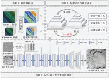
Fig. 1
The overall framework of the proposed terrain-guided super-resolution reconstruction method"


Fig. 2
Distribution of DEM dataset in the study area"
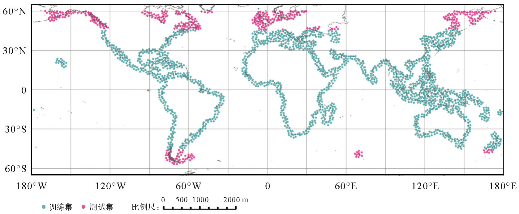

Fig. 3
Examples of high-resolution GEBCO and low-resolution ETOPO-1 DEMs, with slope and surface cutting depth"


Fig. 4
Correlation of terrain factors with DEM in the study area"


Fig. 5
The structure of high-low frequency feature decoupling module"


Fig. 6
The structure of terrain guidance module"
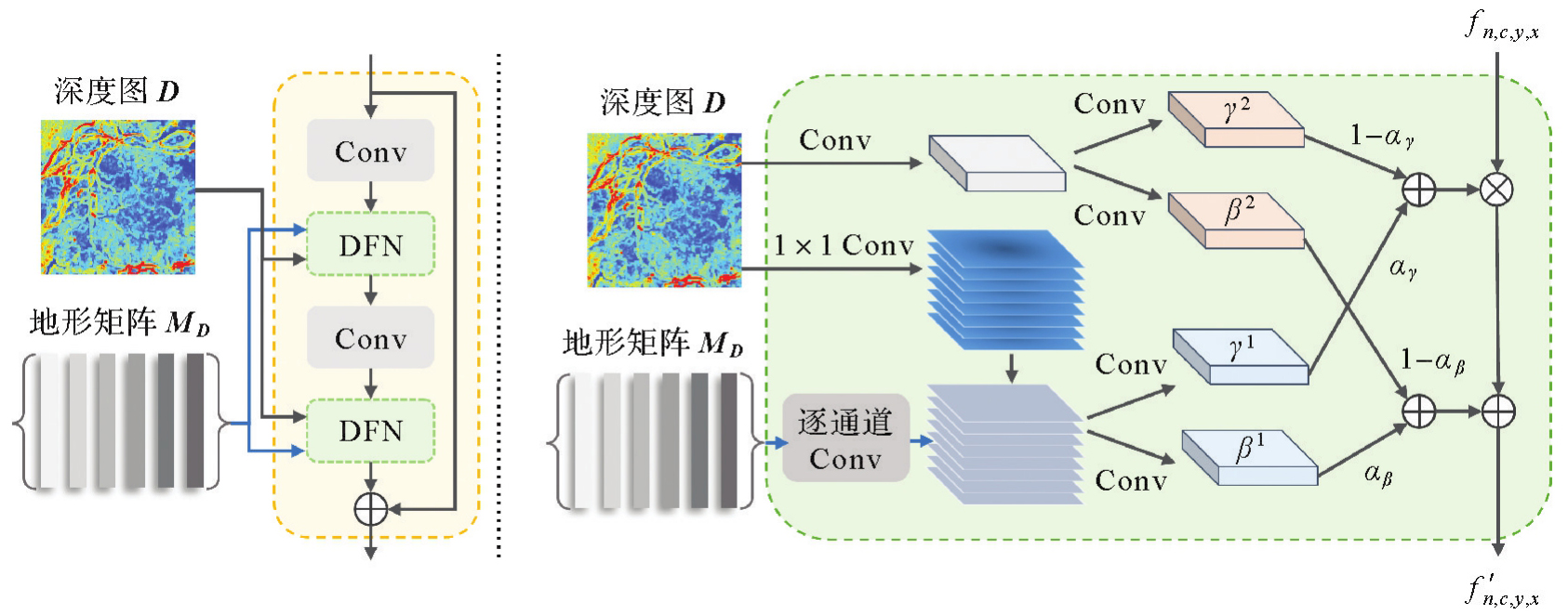

Fig. 7
Comparison of network training curves for different loss functions"


Fig. 8
The results of DEM super-resolution reconstruction methods"

Tab. 1
Quantitative results of different methods"
| 方法 | RMSEelevation/m | MAEelevation/m | RMSEslope/(°) |
|---|---|---|---|
| 双三次插值 | 29.084 | 22.556 | 5.234 |
| ESRGAN | 27.385 | 20.252 | 4.788 |
| EDSR | 27.259 | 20.654 | 4.754 |
| SwinIR | 27.220 | 20.418 | 4.723 |
| SRFormer | 26.286 | 19.455 | 4.678 |
| TfaSR | 25.991 | 19.239 | 4.347 |
| StfeT | 26.803 | 19.642 | 4.691 |
| 本文方法 | 25.543 | 19.132 | 4.289 |
Tab. 2
Quantitative results of ablation experiments"
| 方法 | RMSEelevation/m | MAEelevation/m | RMSEslope/(°) |
|---|---|---|---|
| HLF-FDM去掉高频分支 | 26.148 | 19.401 | 4.526 |
| HLF-FDM去掉低频分支 | 25.821 | 19.334 | 4.315 |
| 去掉TGM | 26.765 | 19.682 | 4.681 |
| 本文方法 | 25.543 | 19.132 | 4.289 |
Tab. 3
Quantitative results and parameter comparison of HLF-FDM and TGM at different iteration counts"
| 迭代次数 | RMSEelevation/m | MAEelevation/m | RMSEslope/(°) | FLOPs | 参数量 |
|---|---|---|---|---|---|
| 5 | 26.118 | 19.451 | 4.598 | 2.556×10⁶ | 98.438 |
| 6(本文方法) | 25.543 | 19.132 | 4.289 | 3.000×10⁶ | 112.988 |
| 7 | 25.776 | 19.284 | 4.230 | 3.444×10⁶ | 127.538 |
Tab. 4
Quantitative results of different loss functions"
| 损失函数 | RMSEelevation/m | MAEelevation/m | RMSEslope/(°) | ||
|---|---|---|---|---|---|
 |  |  | |||
| √ | 26.261 | 19.423 | 4.639 | ||
| √ | √ | 25.782 | 19.308 | 4.517 | |
| √ | √ | √ | 25.543 | 19.132 | 4.289 |
| [1] | 汤国安, 李发源, 刘学军. 数字高程模型教程[M]. 3版. 北京: 科学出版社, 2016. |
| TANG Guoan, LI Fayuan, LIU Xuejun. Digital elevation model course[M]. 3rd ed. Beijing: Science Press, 2016. | |
| [2] | 王光霞, 朱长青, 史文中, 等. 数字高程模型地形描述精度的研究[J]. 测绘学报, 2004, 33(2): 168-173. |
| WANG Guangxia, ZHU Changqing, SHI Wenzhong, et al. The further study on the accuracy of DEM terrain representation[J]. Acta Geodaetica et Cartographica Sinica, 2004, 33(2): 168-173. | |
| [3] |
汤国安, 那嘉明, 程维明. 我国区域地貌数字地形分析研究进展[J]. 测绘学报, 2017, 46(10): 1570-1591. DOI: .
doi: 10.11947/j.AGCS.2017.20170388 |
|
TANG Guoan, NA Jiaming, CHENG Weiming. Progress of digital terrain analysis on regional geomorphology in China[J]. Acta Geodaetica et Cartographica Sinica, 2017, 46(10): 1570-1591. DOI: .
doi: 10.11947/j.AGCS.2017.20170388 |
|
| [4] | YANG Jiaqi, XU Jun, ZHU Yunqiang, et al. GeomorPM: a geomorphic pretrained model integrating convolution and Transformer architectures based on DEM data[J]. International Journal of Geographical Information Science, 2025, 39(2): 422-451. |
| [5] | AVAND M, KURIQI A, KHAZAEI M, et al. DEM resolution effects on machine learning performance for flood probability mapping[J]. Journal of Hydro-Environment Research, 2022, 40: 1-16. |
| [6] |
赵建虎, 欧阳永忠, 王爱学. 海底地形测量技术现状及发展趋势[J]. 测绘学报, 2017, 46(10): 1786-1794. DOI: .
doi: 10.11947/j.AGCS.2017.20170276 |
|
ZHAO Jianhu, OUYANG Yongzhong, WANG Aixue. Status and development tendency for seafloor terrain measurement technology[J]. Acta Geodaetica et Cartographica Sinica, 2017, 46(10): 1786-1794. DOI: .
doi: 10.11947/j.AGCS.2017.20170276 |
|
| [7] |
李鹏. 海岸带地理环境雷达遥感监测关键问题研究[J]. 测绘学报, 2021, 50(4): 565. DOI: .
doi: 10.11947/j.AGCS.2021.20200165 |
|
LI Peng. Key issues on coastal geographical environment monitoring with radar remote sensing[J]. Acta Geodaetica et Cartographica Sinica, 2021, 50(4): 565. DOI: .
doi: 10.11947/j.AGCS.2021.20200165 |
|
| [8] | KARIMINEJAD N, HOSSEINALIZADEH M, POURGHASEMI H R, et al. Optimizing collapsed pipes mapping: effects of DEM spatial resolution[J]. Catena, 2020, 187: 104344. |
| [9] | 王耀革, 王鑫, 朱长青. 基于双线性内插规则格网DEM地形误差模型[J]. 测绘科学技术学报, 2007, 24(6): 419-421. |
| WANG Yaoge, WANG Xin, ZHU Changqing. A terrain error model of grid DEM based on bilinear polynomial[J]. Journal of Zhengzhou Institute of Surveying and Mapping, 2007, 24(6): 419-421. | |
| [10] | KEYS R G. Cubic convolution interpolation for digital image processing[J]. IEEE Transactions on Acoustics Speech and Signal Processing, 1981, 29: 1153-1160. |
| [11] | 郭伟伟, 章品正. 基于迭代反投影的超分辨率图像重建[J]. 计算机科学与探索, 2009, 3(3): 321-329. |
| GUO Weiwei, ZHANG Pinzheng. Super-resolution image reconstruction with iterative back projection algorithm[J]. Journal of Frontiers of Computer Science & Technology, 2009, 3(3): 321-329. | |
| [12] | PROTTER M, ELAD M, TAKEDA H, et al. Generalizing the nonlocal-means to super-resolution reconstruction[J]. IEEE Transactions on Image Processing, 2009, 18(1): 36-51. |
| [13] | DONG Chao, LOY C C, HE Kaiming, et al. Image super-resolution using deep convolutional networks[J]. IEEE Transactions on Pattern Analysis and Machine Intelligence, 2016, 38(2): 295-307. |
| [14] | LIM B, SON S, KIM H, et al. Enhanced deep residual networks for single image super-resolution[C]//Proceedings of 2017 IEEE Conference on Computer Vision and Pattern Recognition Workshops. Honolulu: IEEE, 2017: 136-144. |
| [15] | LEDIG C, THEIS L, HUSZÁR F, et al. Photo-realistic single image super-resolution using a generative adversarial network[C]//Proceedings of 2017 IEEE Conference on Computer Vision and Pattern Recognition. Honolulu: IEEE, 2017: 105-114. |
| [16] | WANG Xintao, YU Ke, WU Shixiang, et al. ESRGAN: enhanced super-resolution generative adversarial networks[C]//Proceedings of 2018 European Conference on Computer Vision. Cham: Springer, 2019: 63-79. |
| [17] | ZHANG Yifan, YU Wenhao, ZHU Di. Terrain feature-aware deep learning network for digital elevation model superresolution[J]. ISPRS Journal of Photogrammetry and Remote Sensing, 2022, 189: 143-162. |
| [18] | DAI Jifeng, QI Haozhi, XIONG Yuwen, et al. Deformable convolutional networks[C]//Proceedings of 2017 IEEE International Conference on Computer Vision. Venice: IEEE, 2017: 764-773. |
| [19] | 侯旭娟, 邓筱曈, 花卫华, 等. 基于自适应生成对抗网络的DEM超分辨率重建方法[J/OL]. 武汉大学学报(信息科学版). [2025-02-20]. https://doi.org/10.13203/j.whugis20240186. |
| HOU Xujuan, DENG Xiaotong, HUA Weihua, et al. DEM super-resolution reconstruction method based on adaptive generative adversarial network[J/OL]. Geomatics and Information Science of Wuhan University. [2025-02-20]. https://doi.org/10.13203/j.whugis20240186. | |
| [20] | 陈凯, 雷少华, 代文, 等. 基于开源数据和条件生成对抗网络的地形重建方法[J]. 地球信息科学学报, 2023, 25(2): 252-264. |
| CHEN Kai, LEI Shaohua, DAI Wen, et al. Terrain rebuilding method based on open source data and conditional generative adversarial networks[J]. Journal of Geo-information Science, 2023, 25(2): 252-264. | |
| [21] | CAI Wuxu, LIU Yanxiong, CHEN Yilan, et al. A seabed terrain feature extraction transformer for the super-resolution of the digital bathymetric model[J]. Remote Sensing, 2023, 15(20): 4906. |
| [22] | WANG Yi, JIN Shichao, YANG Zekun, et al. TTSR: a Transformer-based topography neural network for digital elevation model super-resolution[J]. IEEE Transactions on Geoscience and Remote Sensing, 2024, 62: 3360489. |
| [23] | TOZER B, SANDWELL D T, SMITH W H F, et al. Global bathymetry and topography at 15 arcsec: SRTM15+[J]. Earth and Space Science, 2019, 6(10): 1847-1864. |
| [24] | AMANTE C, EAKINS B W. ETOPO1 arc-minute global relief model: procedures, data sources and analysis[R]. Boulder: National Geophysical Data Center, 2009. |
| [25] | HENDRYCKS D, GIMPEL K. Gaussian error linear units (GELUs)[EB/OL]. [2025-02-20]. https://arxiv.org/abs/1606.08415. |
| [26] | IOFFE S, SZEGEDY C. Batch normalization: accelerating deep network training by reducing internal covariate shift[C]//Proceedings of 2015 International Conference on Machine Learning. Lille: PMLR, 2015: 448-456. |
| [27] | ULYANOV D, VEDALDI A, LEMPITSKY V. Improved texture networks: maximizing quality and diversity in feed-forward stylization and texture synthesis[C]//Proceedings of 2017 IEEE Conference on Computer Vision and Pattern Recognition. Honolulu: IEEE, 2017: 4105-4113. |
| [28] | SALIMANS T, KINGMA D P. Weight normalization: a simple reparameterization to accelerate training of deep neural networks[C]//Proceedings of the 30th International Conference on Neural Information Processing Systems. Red Hook: Curran Associates Inc., 2016: 901-909. |
| [29] | CIPOLLA R, GAL Y, KENDALL A. Multi-task learning using uncertainty to weigh losses for scene geometry and semantics[C]//Proceedings of 2018 IEEE/CVF Conference on Computer Vision and Pattern Recognition. Salt Lake City: IEEE, 2018: 7482-7491. |
| [30] | LIANG Jingyun, CAO Jiezhang, SUN Guolei, et al. SwinIR: image restoration using swin transformer[C]//Proceedings of 2021 IEEE/CVF International Conference on Computer Vision Workshops. Montreal: IEEE, 2021: 1833-1844. |
| [31] | ZHOU Yupeng, LI Zhen, GUO Chunle, et al. SRFormer: permuted self-attention for single image super-resolution[C]//Proceedings of 2023 IEEE/CVF International Conference on Computer Vision. Paris: IEEE, 2023: 12734-12745. |
| [32] | LIU Hongying, LI Zekun, SHANG Fanhua, et al. Arbitrary-scale super-resolutionvia deep learning: a comprehensive survey[J]. Information Fusion, 2024, 102: 102015. |
| [33] |
孙群, 温伯威, 陈欣. 多源地理空间数据一致性处理研究进展[J]. 测绘学报, 2022, 51(7): 1561-1574. DOI: .
doi: 10.11947/j.AGCS.2022.20220151 |
|
SUN Qun, WEN Bowei, CHEN Xin. Research on consistency processing of multi-source geospatial data[J]. Acta Geodaetica et Cartographica Sinica, 2022, 51(7): 1561-1574. DOI: .
doi: 10.11947/j.AGCS.2022.20220151 |
|
| [34] |
孙群, 任福, 龙毅, 等. 中国地图制图学与地理信息工程进展报告(2019—2023)[J]. 测绘学报, 2024, 53(3): 399-412. DOI: .
doi: 10.11947/j.AGCS.2024.20230562 |
|
SUN Qun, REN Fu, LONG Yi, et al. The progress and trend of cartography and geographic information engineering in China (2019—2023)[J]. Acta Geodaetica et Cartographica Sinica, 2024, 53(3): 399-412. DOI: .
doi: 10.11947/j.AGCS.2024.20230562 |
| [1] | Jie WAN, Zhong XIE, Yongyang XU, Liufeng TAO. A U-shaped graph convolution network method for semantic segmentation of vehicle LiDAR point clouds towards urban road scenes [J]. Acta Geodaetica et Cartographica Sinica, 2025, 54(7): 1280-1293. |
| [2] | Yiming ZHAO, Kelin HU, Kelong TU, Yaxian QING, Chao YANG, Kunlun QI, Huayi WU. Multi-label scene classification method based on fusion of SAR and optical remote sensing images [J]. Acta Geodaetica et Cartographica Sinica, 2025, 54(5): 911-923. |
| [3] | Yungang CAO, Peng YANG, Jiangbo GONG, Gao ZHU, Xingyu SHEN. A road extraction method integrating spatial-relation enhancement and heterogeneous feature fusion [J]. Acta Geodaetica et Cartographica Sinica, 2025, 54(12): 2219-2232. |
| [4] | Liangxiong GONG, Xinghua LI, Yuanming CHENG, Xingyou ZHAO, Renping XIE, Honggen WANG. A lightweight remote sensing images change detection network utilizing spatio-temporal difference enhancement and adaptive feature fusion [J]. Acta Geodaetica et Cartographica Sinica, 2025, 54(1): 136-153. |
| [5] | Jianbo TANG, Zhiyuan HU, Ju PENG, Heyan XIA, Junjie DING, Yuyu ZHANG, Xiaoming MEI. A road intersection recognition method in crowdsourced trajectory data by fusing visual features and motion features [J]. Acta Geodaetica et Cartographica Sinica, 2025, 54(1): 182-193. |
| [6] | Fubing ZHANG, Qun SUN, Jingzhen MA, Shijie SUN, Bowei WEN. An intelligent classification method for building shape based on fusion of global and local features [J]. Acta Geodaetica et Cartographica Sinica, 2024, 53(9): 1842-1852. |
| [7] | Xin YAN, Li SHEN, Junjie PAN, Yanshuai DAI, Jicheng WANG, Xiaoli ZHENG, Zhi-lin LI. Weakly supervised building change detection integrating multi-scale feature fusion and spatial refinement for high resolution remote sensing images [J]. Acta Geodaetica et Cartographica Sinica, 2024, 53(8): 1586-1597. |
| [8] | Tao XU, Yuanwei YANG, Xianjun GAO, Zhiwei WANG, Yue PAN, Shaohua LI, Lei XU, Yanjun WANG, Bo LIU, Jing YU, Fengmin WU, Haoyu SUN. Integrated graph convolution and multi-scale features for the overhead catenary system point cloud semantic segmentation [J]. Acta Geodaetica et Cartographica Sinica, 2024, 53(8): 1624-1633. |
| [9] | LIN Yunhao, WANG Yanjun, LI Shaochun, CAI Hengfan. A coupled DeepLab and Transformer approach for fine classification of crop cultivation types in remote sensing [J]. Acta Geodaetica et Cartographica Sinica, 2024, 53(2): 353-366. |
| [10] | ZHANG Caili, XIANG Longgang, LI Yali, GAO Songfeng, PAN Chuanjiao. Road section navigation attribute mining [J]. Acta Geodaetica et Cartographica Sinica, 2024, 53(2): 367-378. |
| [11] | Shiyan PANG, Jingjing HAO, Zhiqi ZUO, Jingjing LAN, Xiangyun HU. A high-resolution remote sensing images change detection method via the integration of dense connections and self-attention mechanisms [J]. Acta Geodaetica et Cartographica Sinica, 2024, 53(12): 2244-2253. |
| [12] | SONG Jiaxuan, FAN Dazhao, DONG Yang, JI Song, LI Dongzi. Line matching algorithm for cross-view images combining neural network learning with grayscale information [J]. Acta Geodaetica et Cartographica Sinica, 2023, 52(6): 990-999. |
| [13] | LIU Shuai, LI Xiaoying, YU Meng, XING Guanglong. Dual decoupling semantic segmentation model for high-resolution remote sensing images [J]. Acta Geodaetica et Cartographica Sinica, 2023, 52(4): 638-647. |
| [14] | YU Donghang, XU Qing, ZHAO Chuan, GUO Haitao, LU Jun, LIN Yuzhun, LIU Xiangyun. Attention-guided feature fusion and joint learning for remote sensing image scene classification [J]. Acta Geodaetica et Cartographica Sinica, 2023, 52(4): 624-637. |
| [15] | HU Anna, LIU Rui, WU Liang, ZHANG Jin, XU Yongyang, CHEN Siqiong. Super-resolution reconstruction method for remote sensing images considering global features and texture features [J]. Acta Geodaetica et Cartographica Sinica, 2023, 52(4): 648-659. |
| Viewed | ||||||
|
Full text |
|
|||||
|
Abstract |
|
|||||