

Acta Geodaetica et Cartographica Sinica ›› 2024, Vol. 53 ›› Issue (8): 1624-1633.doi: 10.11947/j.AGCS.2024.20230198
• Photogrammetry and Remote Sensing • Previous Articles Next Articles
Tao XU1( ), Yuanwei YANG1(), Xianjun GAO1,2, Zhiwei WANG3, Yue PAN3, Shaohua LI1, Lei XU4, Yanjun WANG5,6, Bo LIU2, Jing YU7, Fengmin WU7, Haoyu SUN1
Received:2023-06-08
Online:2024-09-25
Published:2024-09-25
Contact:
Yuanwei YANG
E-mail:2021720578@yangtze.edu.cn;2021720578@yangtze.edu.cn;yyw_08@yangtzeu.edu.cn
About author:XU Tao (1998—), male, postgraduate, majors in the semantic segmentation of 3D point cloud data. E-mail: 2021720578@yangtze.edu.cn
Supported by:CLC Number:
Tao XU, Yuanwei YANG, Xianjun GAO, Zhiwei WANG, Yue PAN, Shaohua LI, Lei XU, Yanjun WANG, Bo LIU, Jing YU, Fengmin WU, Haoyu SUN. Integrated graph convolution and multi-scale features for the overhead catenary system point cloud semantic segmentation[J]. Acta Geodaetica et Cartographica Sinica, 2024, 53(8): 1624-1633.
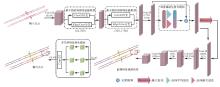
Fig.1
GDM-net network"
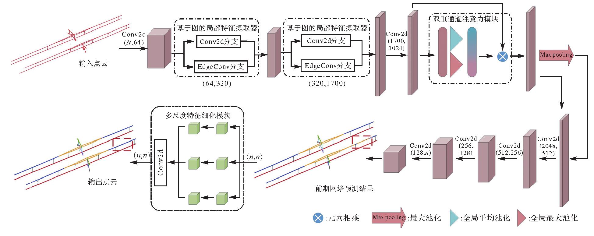
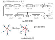
Fig.2
Graph-based local feature extractor"
Fig.3
The structure of dual-channel attention model"
Fig.4
The multi-scale feature refinement module"
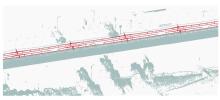
Fig.5
The OCS extraction point cloud results by preprocessing"

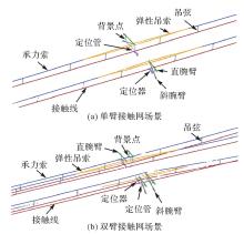
Fig.6
Component of the OCS"
Tab.1
Data distribution introduction in the OCS dataset"
| 数据集 | 单臂 | 双臂 | 训练集 | 验证集 | 测试集 | |||
|---|---|---|---|---|---|---|---|---|
| 单臂 | 双臂 | 单臂 | 双臂 | 单臂 | 双臂 | |||
| 场景数 | 68 | 20 | 55 | 15 | 11 | 4 | 2 | 1 |
| 点的数量 | 3.54×10⁷ | 1.4×10⁷ | 2.9×10⁷ | 1.1×10⁷ | 5.7×10⁶ | 2.8×10⁶ | 1.04×10⁶ | 7×10⁵ |
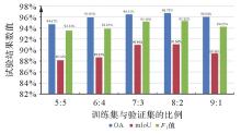
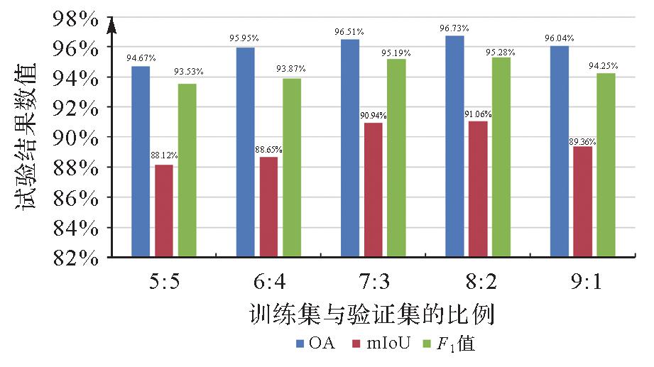
Fig.7
Quantitative comparison of different training/testing ratios"
Tab.2
Quantitative evaluation results of the comparative methods for each category in the OCS dataset"
| 方法 | 评价精度 | 承力索 | 定位器 | 斜腕臂 | 直腕臂 | 弹性吊索 | 定位管 | 背景 | 吊弦 | 接触线 |
|---|---|---|---|---|---|---|---|---|---|---|
| PointNet | P | 83.20 | 70.23 | 77.09 | 74.70 | 79.42 | 62.24 | 50.04 | 88.17 | 98.29 |
| R | 90.54 | 81.88 | 92.94 | 98.16 | 63.18 | 87.72 | 48.32 | 57.58 | 97.03 | |
| mIoU | 76.55 | 60.79 | 72.82 | 73.67 | 64.29 | 61.25 | 50.09 | 53.46 | 95.42 | |
| F1值 | 86.72 | 75.61 | 84.28 | 84.84 | 70.38 | 72.82 | 49.17 | 69.67 | 97.66 | |
| PointNet++ | P | 86.86 | 96.36 | 94.63 | 94.56 | 84.65 | 91.63 | 87.76 | 83.66 | 96.1 |
| R | 90.65 | 93.65 | 96.28 | 92.34 | 86.33 | 93.36 | 87.36 | 83.09 | 98.19 | |
| mIoU | 76.12 | 86.95 | 91.36 | 91.92 | 72.58 | 88.50 | 79.36 | 80.91 | 94.93 | |
| F1值 | 88.71 | 94.99 | 95.46 | 93.45 | 85.48 | 92.49 | 87.56 | 83.37 | 97.13 | |
| DGCNN | P | 92.81 | 98.55 | 96.62 | 96.56 | 86.80 | 93.07 | 87.98 | 85.61 | 99.33 |
| R | 92.69 | 94.74 | 94.89 | 96.56 | 87.80 | 95.51 | 87.29 | 85.69 | 99.19 | |
| mIoU | 86.48 | 93.44 | 91.85 | 93.34 | 77.46 | 89.17 | 77.99 | 74.90 | 98.53 | |
| F1值 | 92.75 | 96.61 | 95.75 | 96.56 | 87.30 | 94.27 | 87.63 | 85.65 | 99.26 | |
| PointNeXt | P | 90.34 | 98.56 | 99.27 | 94.70 | 95.18 | 96.55 | 93.31 | 94.25 | 98.87 |
| R | 96.65 | 96.07 | 94.98 | 98.87 | 85.69 | 98.69 | 92.86 | 88.56 | 99.71 | |
| mIoU | 87.60 | 94.75 | 94.32 | 93.69 | 82.13 | 95.33 | 87.06 | 84.03 | 98.58 | |
| F1值 | 93.39 | 97.30 | 97.08 | 96.74 | 90.19 | 97.61 | 93.08 | 91.32 | 99.29 | |
| Pix4point | P | 96.49 | 96.59 | 99.36 | 94.76 | 91.56 | 87.91 | 91.12 | 89.71 | 99.56 |
| R | 97.26 | 93.67 | 95.05 | 98.48 | 93.86 | 97.85 | 92.13 | 88.46 | 99.44 | |
| mIoU | 91.13 | 90.67 | 94.47 | 93.39 | 86.39 | 86.24 | 89.90 | 77.89 | 99.00 | |
| F1值 | 96.87 | 95.11 | 97.16 | 96.59 | 92.70 | 92.61 | 91.62 | 89.08 | 99.50 | |
| GDM-Net | P | 96.25 | 98.69 | 98.15 | 96.24 | 94.53 | 91.64 | 93.61 | 91.84 | 99.53 |
| R | 96.85 | 94.67 | 95.16 | 97.81 | 90.18 | 97.91 | 92.94 | 87.38 | 99.61 | |
| mIoU | 91.45 | 93.49 | 93.48 | 94.21 | 87.71 | 89.88 | 89.06 | 81.09 | 99.15 | |
| F1值 | 95.53 | 96.64 | 96.63 | 97.02 | 92.31 | 94.67 | 93.27 | 89.56 | 99.57 |
Tab.3
Quantitative evaluation of the comparative methods on the OCS point cloud dataset"
| 方法 | P | R | OA | mIoU | F1值 |
|---|---|---|---|---|---|
| PointNet | 75.93 | 79.70 | 88.26 | 64.09 | 77.77 |
| PointNet++ | 90.69 | 91.25 | 92.34 | 84.37 | 90.96 |
| DGCNN | 93.04 | 92.71 | 94.93 | 87.02 | 92.87 |
| PointNeXt | 95.67 | 94.68 | 96.05 | 90.83 | 95.17 |
| Pix4point | 94.12 | 95.13 | 96.54 | 89.90 | 94.62 |
| GDM-Net | 95.61 | 94.94 | 96.73 | 91.06 | 95.28 |
Fig.8
Semantic segmentation results of the OCS point cloud based on different methods"

Tab.4
Comparison of network parameter quantity, FLOPs and test time of the six methods"
| 方法 | 参数 | FLOPs | 每点测试时间/μs |
|---|---|---|---|
| PointNet | 3.55×10⁶ | 58.53×10⁹ | 16.21 |
| PointNet++ | 1.24×10⁶ | 10.72×10⁹ | 20.51 |
| DGCNN | 2.64×10⁶ | 64.24×10⁹ | 17.35 |
| PointNeXt | 41.60×10⁶ | 84.80×10⁹ | 18.81 |
| Pix4Point | 23.70×10⁶ | 190.00×10⁹ | 21.36 |
| GDM-Net | 3.42×10⁶ | 133.87×10⁹ | 24.41 |
Tab.5
Quantitative evaluation of the comparative methods on the urban railway dataset"
| 方法 | mIoU | 类别名称 | ||||||||||
|---|---|---|---|---|---|---|---|---|---|---|---|---|
| 轨道 | 道床 | 悬链线 | 围栏 | 植被 | 立柱 | 钢结构 | 地面 | 建筑物 | 支持装置 | 背景点 | ||
| PointNet | 11.72 | 5.51 | 6.83 | 13.66 | 7.01 | 38.20 | 2.36 | 7.66 | 25.49 | 6.45 | 7.56 | 8.21 |
| PointNet++ | 34.28 | 25.86 | 36.63 | 56.36 | 15.63 | 60.82 | 9.62 | 23.36 | 57.36 | 32.36 | 28.69 | 30.35 |
| DGCNN | 24.05 | 21.08 | 16.89 | 26.31 | 17.21 | 61.15 | 9.63 | 8.65 | 38.15 | 19.63 | 9.56 | 36.30 |
| PointNeXt | 75.19 | 80.72 | 73.23 | 62.92 | 81.61 | 88.28 | 65.39 | 74.64 | 83.36 | 90.82 | 60.61 | 65.59 |
| Pix4Point | 71.54 | 71.84 | 44.66 | 74.19 | 45.19 | 89.99 | 64.34 | 67.81 | 79.72 | 91.58 | 62.64 | 94.94 |
| GDM-Net | 81.52 | 90.63 | 78.69 | 76.33 | 88.37 | 93.61 | 68.37 | 72.63 | 85.39 | 85.68 | 68.36 | 88.65 |

Fig.9
Visualization comparison of semantic segmentation results for WHU-railway 3D dataset"
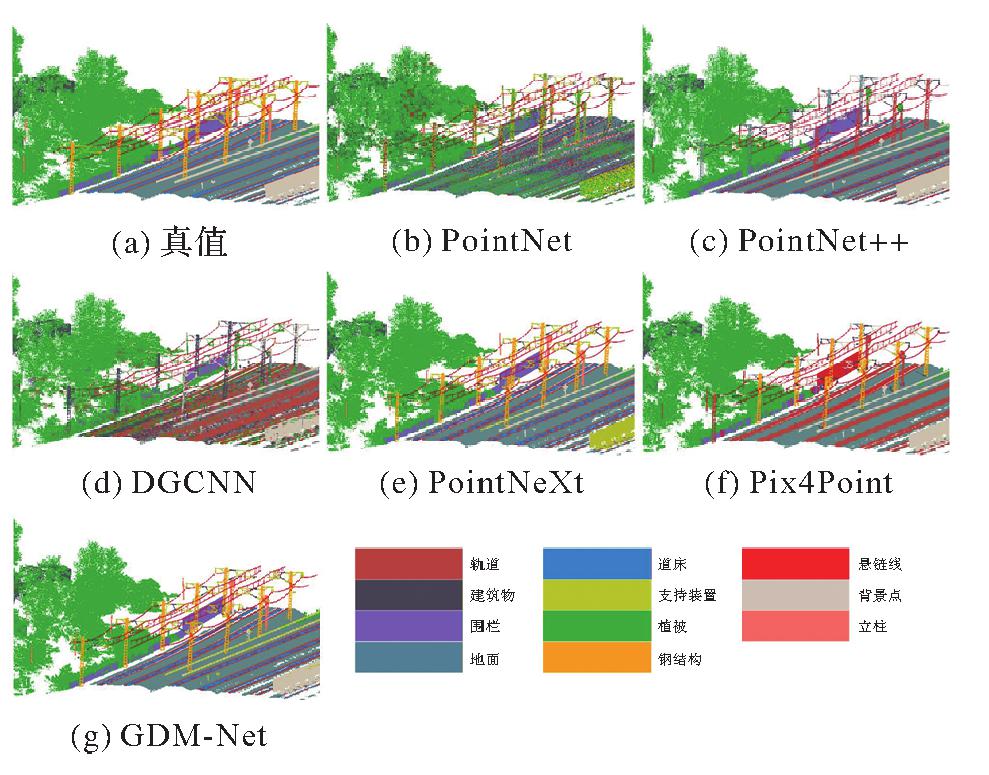

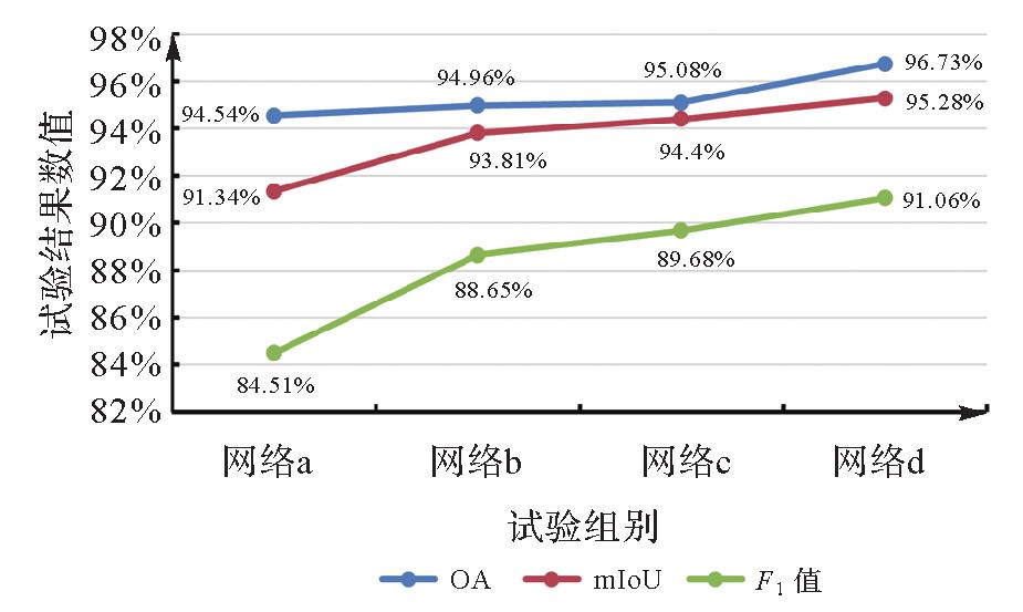
Fig.10
Accuracy comparison diagram of innovative module network"
| [1] | LIN Shuai, XU Cheng, CHEN Lipei, et al. LiDAR point cloud recognition of overhead catenary system with deep learning[J]. Sensors, 2020, 20(8): 2212-2228. |
| [2] | TU Xiaohan, XU Cheng, LIU Siping, et al. LiDAR point cloud recognition and visualization with deep learning for overhead contact inspection[J]. Sensors, 2020, 20(21): 6387-6404. |
| [3] | 杨元维, 张跃, 高贤君, 等. 顾及空间关系的3D LiDAR铁路支持装置自动提取[J]. 浙江大学学报(工学版), 2022, 56(10): 2066-2076. |
| YANG Yuanwei, ZHANG Yue, GAO Xianjun, et al. Automatic extraction of spatially relevant 3D LiDAR railway support facility[J]. Journal of Zhejiang University (Engineering Science), 2022, 56(10): 2066-2076. | |
| [4] | 杨必胜, 梁福逊, 黄荣刚. 三维激光扫描点云数据处理研究进展、挑战与趋势[J]. 测绘学报, 2017, 46(10): 1509-1516. DOI: 10.11947/j.AGCS.2017.20170351. |
| YANG Bisheng, LIANG Fuxun, HUANG Ronggang. Progress, challenges and perspectives of 3D LiDAR point cloud processing[J]. Acta Geodaetica et Cartographica Sinica, 2017, 46(10): 1509-1516. DOI: 10.11947/j.AGCS.2017.20170351. | |
| [5] | 周靖松, 韩志伟, 杨长江. 基于三维点云的接触网几何参数检测方法[J]. 仪器仪表学报, 2018, 39(4): 239-246. |
| ZHOU Jingsong, HAN Zhiwei, YANG Changjiang. Catenary geometric parameters detection method based on 3D point cloud[J]. Chinese Journal of Scientific Instrument, 2018, 39(4): 239-246. | |
| [6] | 张东, 余朝刚. 基于激光扫描的接触网几何参数检测方法研究[J]. 计算机测量与控制, 2016, 24(1): 57-60. |
| ZHANG Dong, YU Chaogang. Catenary geometry parameter detection method based on laser scanning[J]. Computer Measurement & Control, 2016, 24(1): 57-60. | |
| [7] | 罗隆福, 叶威, 王健. 基于深度学习的高铁接触网顶紧螺栓的缺陷检测[J]. 铁道科学与工程学报, 2021, 18(3): 605-614. |
| LUO Longfu, YE Wei, WANG Jian. Defect detection of the puller bolt in high-speed railway catenary based on deep learning[J]. Journal of Railway Science and Engineering, 2021, 18(3): 605-614. | |
| [8] | XIE Yuxing, TIAN Jiaojiao, ZHU Xiaoxiang. Linking points with labels in 3D: a review of point cloud semantic segmentation[J]. IEEE Geoscience and Remote Sensing Magazine, 2020, 8(4): 38-59. |
| [9] | DERPANIS K G. Overview of the RANSAC algorithm[J]. Image Rochester NY, 2010, 4(1): 2-3. |
| [10] | SCHUBERT E, SANDER J, ESTER M, et al. DBSCAN revisited, revisited: why and how you should (still) use DBSCAN[J]. ACM Transactions on Database Systems, 2017, 42(3): 1-21. |
| [11] | AHMAD A, DEY L. A k-mean clustering algorithm for mixed numeric and categorical data[J]. Data & Knowledge Engineering, 2007, 63(2): 503-527. |
| [12] | ZHANG Jixian, LIN Xiangguo, NING Xiaogang. SVM-based classification of segmented airborne LiDAR point clouds in urban areas[J]. Remote Sensing, 2013, 5(8): 3749-3775. |
| [13] | 孙杰, 赖祖龙. 利用随机森林的城区机载LiDAR数据特征选择与分类[J]. 武汉大学学报(信息科学版), 2014, 39(11): 1310-1313. |
| SUN Jie, LAI Zulong. Airborne LiDAR feature selection for urban classification using random forests[J]. Geomatics and Information Science of Wuhan University, 2014, 39(11): 1310-1313. | |
| [14] | LALONDE J F, UNNIKRISHNAN R, VANDAPEL N, et al. Scale selection for classification of point-sampled 3D surfaces[C]//Proceedings of 2005 International Conference on 3D Digital Imaging and Modeling. Ottawa: IEEE, 2005: 285-292. |
| [15] | 张广斌, 高贤君, 冉树浩, 等. 高分遥感影像云雪共存区轻量云高精度检测方法[J]. 测绘学报, 2023, 52(1): 93-107. DOI: 10.11947/j.AGCS.2023.20210686. |
| ZHANG Guangbin, GAO Xianjun, RAN Shuhao, et al. Accurate and lightweight cloud detection method based on cloud and snow coexistence region of high-resolution remote sensing images[J]. Acta Geodaetica et Cartographica Sinica, 2023, 52(1): 93-107. DOI: 10.11947/j.AGCS.2023.20210686. | |
| [16] | 张佳颖, 赵晓丽, 陈正. 基于深度学习的点云语义分割综述[J]. 激光与光电子学进展, 2020, 57(4): 28-46. |
| ZHANG Jiaying, ZHAO Xiaoli, CHEN Zheng. Review of semantic segmentation of point cloud based on deep learning[J]. Laser & Optoelectronics Progress, 2020, 57(4): 28-46. | |
| [17] | YANG Zhixin, TANG Lulu, ZHANG Kun, et al. Multi-view CNN feature aggregation with ELM auto-encoder for 3D shape recognition[J]. Cognitive Computation, 2018, 10(6): 908-921. |
| [18] | RIEGLER G, ULUSOY A O, GEIGER A. OctNet: learning deep 3D representations at high resolutions[C]//Proceedings of 2017 IEEE Conference on Computer Vision and Pattern Recognition. Honolulu: IEEE, 2017: 6620-6629. |
| [19] | CHARLES R Q, SU H, MO K C, et al. PointNet: deep learning on point sets for 3D classification and segmentation[C]//Proceedings of 2017 IEEE Conference on Computer Vision and Pattern Recognition. Honolulu: IEEE, 2017: 77-85. |
| [20] | QI C R, YI L, SU H, et al. PointNet++: deep hierarchical feature learning on point sets in a metric space[J]. Advances in Neural Information Processing Systems, 2017, 30: 5099-5108. |
| [21] | WANG Yue, SUN Yongbin, LIU Ziwei, et al. Dynamic graph CNN for learning on point clouds[J]. ACM Transactions on Graphics, 2019, 38(5): 1-12. |
| [22] | GRAHAM B, ENGELCKE M, VAN DER MAATEN L. 3D semantic segmentation with submanifold sparse convolutional networks[C]//Proceedings of 2018 IEEE/CVF Conference on Computer Vision and Pattern Recognition. Salt Lake City: IEEE, 2018: 9224-9232. |
| [23] | WANG Qilong, WU Banggu, ZHU Pengfei, et al. ECA-net: efficient channel attention for deep convolutional neural networks[C]//Proceedings of 2020 IEEE/CVF Conference on Computer Vision and Pattern Recognition. Seattle: IEEE, 2020: 11531-11539. |
| [24] | JIANG Tengping, YANG Bisheng, WANG Yongjun, et al. RailSeg: learning local-global feature aggregation with contextual information for railway point cloud semantic segmentation [J]. IEEE Transactions on Geoscience and Remote Sensing, 2023, 61: 1-29. |
| [25] | RUBINSTEIN R Y, KROESE D P. A tutorial introduction to the cross-entropy method[M]//Information science and statistics. New York: Springer, 2004: 29-58. |
| [26] | CHEN Zhanlong, LI Shuangjiang, XU Yongyang, et al. Correg-Yolov3: a method for dense buildings detection in high-resolution remote sensing images[J]. Journal of Geodesy and Geoinformation Science, 2023, 6(2): 51-61. |
| [27] | QIAN Guocheng, LI Yuchen, PENG Houwen, et al. Pointnext: revisiting Pointnet++ with improved training and scaling strategies[J]. Advances in Neural Information Processing Systems, 2022, 35: 23192-23204. |
| [1] | Zhuang SUN, Po LIU, Liang ZHAI, Yu HE, Zutao ZHANG. A self-supervised matching method for polygonal geographic entity based on a three-branch attention network [J]. Acta Geodaetica et Cartographica Sinica, 2026, 55(1): 169-180. |
| [2] | Weitong WU, Chi CHEN, Bisheng YANG, Xiufeng HE. Robust multi-sensor fusion-based odometry method of LiDAR, millimeter-wave radar and IMU in degraded scenes [J]. Acta Geodaetica et Cartographica Sinica, 2025, 54(9): 1677-1686. |
| [3] | Dongdong PU, Hongzhou CHAI, Yongzhong OUYANG, Chao DONG. Hierarchical encryption matching algorithm for adjacent strip splicing in airborne LiDAR bathymetry [J]. Acta Geodaetica et Cartographica Sinica, 2025, 54(8): 1439-1451. |
| [4] | Qing CHENG, Boxuan WANG, Hongyan ZHANG. DRformer: a progressive coupled multiscale CNN and condensed attention Transformer method for hyperspectral image super-resolution [J]. Acta Geodaetica et Cartographica Sinica, 2025, 54(7): 1230-1242. |
| [5] | Jie WAN, Zhong XIE, Yongyang XU, Liufeng TAO. A U-shaped graph convolution network method for semantic segmentation of vehicle LiDAR point clouds towards urban road scenes [J]. Acta Geodaetica et Cartographica Sinica, 2025, 54(7): 1280-1293. |
| [6] | Dianpeng SU, Bin WANG, Xiaozheng MAI, Huang MENG, Chao QI, Fanlin YANG. Calibration of placement angle errors of airborne bathymetric LiDAR without field control [J]. Acta Geodaetica et Cartographica Sinica, 2025, 54(6): 1042-1053. |
| [7] | Lianzhong XU, Chuanfa CHEN, Dongxing CHEN, Xingjie WANG, Ziming YANG, Shufan YANG, Zhuangzhuang HONG, Jinda HAO. An efficient filtering method considering terrain features for large-scale airborne LiDAR point clouds [J]. Acta Geodaetica et Cartographica Sinica, 2025, 54(6): 1082-1093. |
| [8] | Haolong GAO, Shaobo LI, Jianhu ZHAO. Multipath negative outlier removal method for coastal LiDAR point clouds based on mirror structure and intensity feature constraints [J]. Acta Geodaetica et Cartographica Sinica, 2025, 54(5): 840-852. |
| [9] | Yiming ZHAO, Kelin HU, Kelong TU, Yaxian QING, Chao YANG, Kunlun QI, Huayi WU. Multi-label scene classification method based on fusion of SAR and optical remote sensing images [J]. Acta Geodaetica et Cartographica Sinica, 2025, 54(5): 911-923. |
| [10] | Xing ZHANG, Zhanpeng HUANG, Qingquan LI, Baoding ZHOU, Qipei LI. 3D tunnel mapping method combining registration compensation and spatial constraint [J]. Acta Geodaetica et Cartographica Sinica, 2025, 54(2): 297-307. |
| [11] | Yupeng GU, Wanke LIU, Xiaohong ZHANG, Jie HU, Shujie HU, Weihao LEI, Kai ZHENG. Neural network-based GNSS stochastic model generation method by fisheye images [J]. Acta Geodaetica et Cartographica Sinica, 2025, 54(12): 2206-2218. |
| [12] | Yungang CAO, Peng YANG, Jiangbo GONG, Gao ZHU, Xingyu SHEN. A road extraction method integrating spatial-relation enhancement and heterogeneous feature fusion [J]. Acta Geodaetica et Cartographica Sinica, 2025, 54(12): 2219-2232. |
| [13] | Xiong PAN, Zixuan ZHAO, Chang PING, Lihong JIN, Lilong LIU. Ionospheric TEC prediction incorporating semi-parametric and rule-learning [J]. Acta Geodaetica et Cartographica Sinica, 2025, 54(10): 1741-1756. |
| [14] | Yongjun ZHANG, Changjun ZHU, Siyuan ZOU, Xinyi LIU, Qingzhou MAO, Yi WAN. Registration of aerial images and LiDAR point clouds based on distance field and plane constraints [J]. Acta Geodaetica et Cartographica Sinica, 2025, 54(1): 64-74. |
| [15] | Yanjun WANG, Xuchao TANG, Cheng WANG, Hengfan CAI. Urban and rural road surface extraction network based on road topological correlation features [J]. Acta Geodaetica et Cartographica Sinica, 2025, 54(1): 75-89. |
| Viewed | ||||||
|
Full text |
|
|||||
|
Abstract |
|
|||||