

Acta Geodaetica et Cartographica Sinica ›› 2025, Vol. 54 ›› Issue (2): 297-307.doi: 10.11947/j.AGCS.2025.20240018
• Photogrammetry and Remote Sensing • Previous Articles Next Articles
Xing ZHANG1,2,3,4( ), Zhanpeng HUANG1,2,3,4, Qingquan LI2,3,4,5, Baoding ZHOU2,5(), Qipei LI1,2,3,4
Received:2024-01-12
Online:2025-03-11
Published:2025-03-11
Contact:
Baoding ZHOU
E-mail:xzhang@szu.edu.cn;bdzhou@szu.edu.cn
About author:ZHANG Xing (1982—), male, PhD, associate professor, majors in multi-sensor fusion positioning and 3D mapping. E-mail: xzhang@szu.edu.cn
Supported by:CLC Number:
Xing ZHANG, Zhanpeng HUANG, Qingquan LI, Baoding ZHOU, Qipei LI. 3D tunnel mapping method combining registration compensation and spatial constraint[J]. Acta Geodaetica et Cartographica Sinica, 2025, 54(2): 297-307.
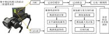
Fig. 1
Framework of the 3D tunnel mapping"
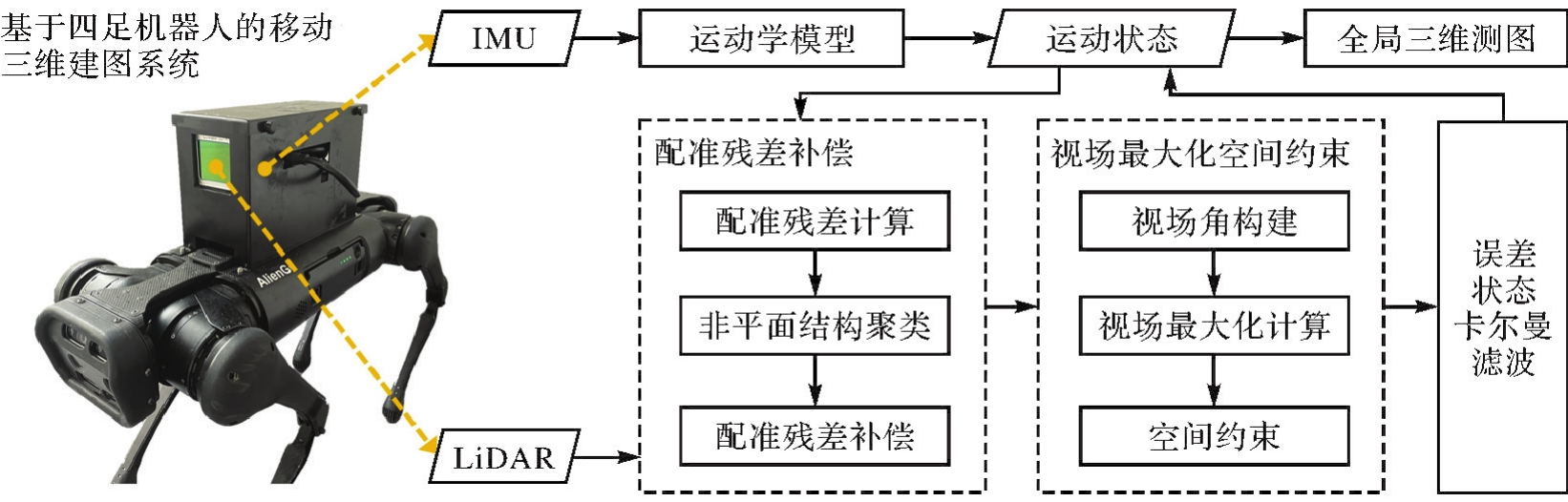
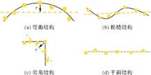
Fig. 2
Real surfaces (gray), fitted planes of neighboring points (dotted line) and residual values r of nonplanar points"
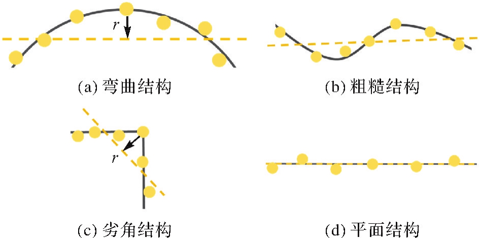
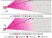
Fig. 3
Spatial constraint based on view field maximization in top view and side view"

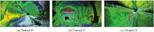
Fig. 4
Examples of experimental scenarios"

Tab. 1
Descriptions of the three datasets"
| 数据集 | 施工阶段 | 长度/m | 激光雷达点数量 | 扫描帧数量 | |||
|---|---|---|---|---|---|---|---|
| FAST-LIO2 | Faster-LIO | LiLi-OM | 本文方法 | ||||
| Tunnel-P | 管沟敷设 | 123.2 | 1 121.9×10⁴ | 1 122.3×10⁴ | 152.0×10⁴ | 1 114.3×10⁴ | 1451 |
| Tunnel-C | 二次衬砌 | 129.0 | 905.1×10⁴ | 905.4×10⁴ | 124.7×10⁴ | 904.9×10⁴ | 1224 |
| Tunnel-T | 管沟敷设 | 101.8 | 1 535.9×10⁴ | 1 535.6×10⁴ | 182.0×10⁴ | 1 448.3×10⁴ | 1767 |
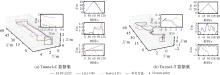
Fig. 5
Results of trajectory closure in the Tunnel-P and Tunnel-T datasets, with details in the XY plane and translation component curves"

Tab. 2
Results of trajectory closure and mapping comparison"
| 方法 | Tunnel-C | Tunnel-T | Tunnel-P | |||
|---|---|---|---|---|---|---|
| CE/m | CE/m | AME/m | RME/(%) | AME/m | RME/(%) | |
| FAST-LIO2 | 0.90 | 0.20 | 0.07 | 1.90 | 0.06 | 1.09 |
| Faster-LIO | 0.59 | 2.04 | 0.27 | 7.38 | 0.12 | 2.06 |
| LiLi-OM | 1.81 | — | — | 1.64 | 28.50 | |
| 本文方法 | 0.01 | 0.03 | 0.02 | 0.49 | 0.02 | 0.26 |
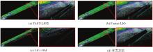
Fig. 6
Results of tunnel mapping in the Tunnel-P dataset"
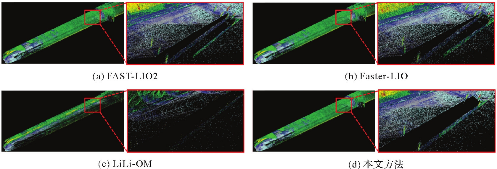
Fig. 7
Results of tunnel mapping in the Tunnel-T dataset"
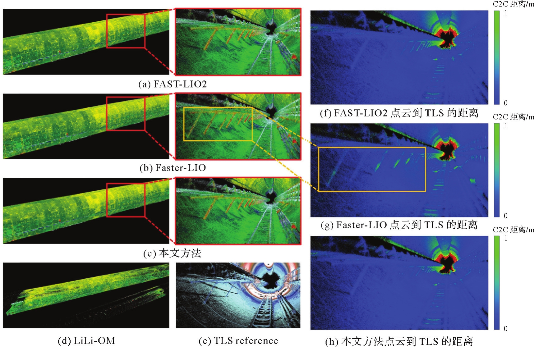
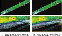
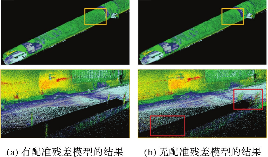
Fig. 8
With and without residual compensation results comparison in the Tunnel-P dataset"
Tab. 3
Ablation studies results comparison"
| 方法 | Tunnel-C | Tunnel-T | Tunnel-P | 计算时间/s | |||
|---|---|---|---|---|---|---|---|
| CE/m | CE/m | AME/m | RME/(%) | AME/m | RME/(%) | ||
| 残差补偿+无空间约束 | 0.56 | 0.19 | 0.06 | 1.57 | 0.07 | 1.17 | 0.012 |
| 无残差补偿+空间约束 | 0.84 | 0.30 | 0.21 | 5.94 | 0.44 | 7.62 | 0.013 |
| 无残差补偿+无空间约束 | 1.04 | 0.51 | 0.39 | 10.76 | 0.57 | 10.03 | 0.012 |
| 残差补偿+空间约束(本文方法) | 0.01 | 0.03 | 0.02 | 0.49 | 0.02 | 0.26 | 0.012 |
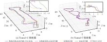
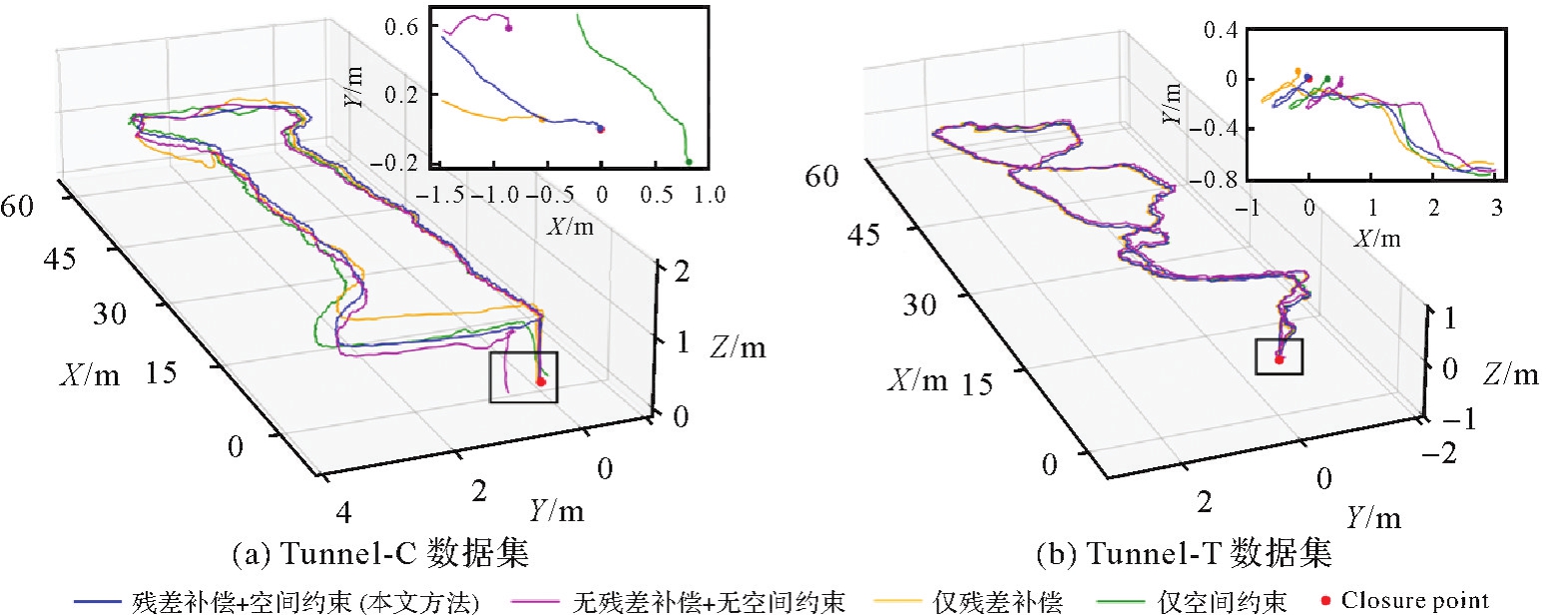
Fig. 9
Trajectory closure results using four different methods in the Tunnel-C and Tunnel-T datasets, with details in the XY plane"
| [1] | LU Chunfang, CAI Chaoxun. Challenges and countermeasures for construction safety during the Sichuan-Tibet railway project[J]. Engineering, 2019, 5(5): 833-838. |
| [2] | WANG Qi, QIN Qian, JIANG Bei, et al. Mechanized construction of fabricated arches for large-diameter tunnels[J]. Automation in Construction, 2021, 124: 103583. |
| [3] | 吴波, 朱林萍, 李扬波, 等. 基于K-means聚类模型的隧道施工安全风险评价方法及应用研究[J]. 重庆交通大学学报(自然科学版), 2023, 42(11): 80-87. |
| WU Bo, ZHU Linping, LI Yangbo, et al. Evaluation method and application of tunnel construction safety risk based on K-means clustering model[J]. Journal of Chongqing Jiaotong University (Natural Science), 2023, 42(11): 80-87. | |
| [4] | SOUSA R L, EINSTEIN H H. Lessons from accidents during tunnel construction[J]. Tunnelling and Underground Space Technology, 2021, 113: 103916. |
| [5] | YE Zijian, YE Ying, ZHANG Chenping, et al. A digital twin approach for tunnel construction safety early warning and management[J]. Computers in Industry, 2023, 144: 103783. |
| [6] | INSA-IGLESIAS M, JENKINS M D, MORISON G. 3D visual inspection system framework for structural condition monitoring and analysis[J]. Automation in Construction, 2021, 128: 103755. |
| [7] | LIU Wenli, WU Xianguo, ZHANG Limao, et al. Sensitivity analysis of structural health risk in operational tunnels[J]. Automation in Construction, 2018, 94: 135-153. |
| [8] |
李珵, 卢小平, 朱宁宁, 等. 基于激光点云的隧道断面连续提取与形变分析方法[J]. 测绘学报, 2015, 44(9): 1056-1062. DOI:.
doi: 10.11947/j.AGCS.2015.20140632 |
|
LI Cheng, LU Xiaoping, ZHU Ningning, et al. Continuously extracting section and deformation analysis for subway tunnel based on LiDAR points[J]. Acta Geodaetica et Cartographica Sinica, 2015, 44(9): 1056-1062. DOI:.
doi: 10.11947/j.AGCS.2015.20140632 |
|
| [9] | SHEN Yueqian, WANG Jinguo, WANG Jinhu, et al. Methodology for extraction of tunnel cross-sections using dense point cloud data[J]. Journal of Geodesy and Geoinformation Science, 2021, 4(2): 56-71. |
| [10] |
李帅鑫, 李九人, 田滨, 等. 面向点云退化的隧道环境的无人车激光SLAM方法[J]. 测绘学报, 2021, 50(11): 1487-1499. DOI:.
doi: 10.11947/j.AGCS.2021.20210248 |
|
LI Shuaixin, LI Jiuren, TIAN Bin, et al. A laser SLAM method for unmanned vehicles in point cloud degenerated tunnel environments[J]. Acta Geodaetica et Cartographica Sinica, 2021, 50(11): 1487-1499. DOI:.
doi: 10.11947/j.AGCS.2021.20210248 |
|
| [11] | GONG Z, LI J, LUO Z P, et al. Mapping and semantic modeling of underground parking lots using a backpack LiDAR system[J]. IEEE Transactions on Intelligent Transportation Systems, 2021, 22(2): 734-746. |
| [12] | JIAO Jianhao, YE Haoyang, ZHU Yilong, et al. Robust odometry and mapping for multi-LiDAR systems with online extrinsic calibration[J]. IEEE Transactions on Robotics, 2023, 38(1): 351-371. |
| [13] |
闫利, 戴集成, 谭骏祥, 等. SLAM激光点云整体精配准位姿图技术[J]. 测绘学报, 2019, 48(3): 313-321. DOI:.
doi: 10.11947/j.AGCS.2019.20170716 |
|
YAN Li, DAI Jicheng, TAN Junxiang, et al. Global fine registration of point cloud in LiDAR SLAM based on pose graph[J]. Acta Geodaetica et Cartographica Sinica, 2019, 48(3): 313-321. DOI:.
doi: 10.11947/j.AGCS.2019.20170716 |
|
| [14] | KOCER B B, TJAHJOWIDODO T, PRATAMA M, et al. Inspection-while-flying: an autonomous contact-based nondestructive test using UAV-tools[J]. Automation in Construction, 2019, 106: 102895. |
| [15] |
王晨捷, 罗斌, 李成源, 等. 无人机视觉SLAM协同建图与导航[J]. 测绘学报, 2020, 49(6): 767-776. DOI:.
doi: 10.11947/j.AGCS.2020.20190145 |
|
WANG Chenjie, LUO Bin, LI Chengyuan, et al. The collaborative mapping and navigation based on visual SLAM in UAV platform[J]. Acta Geodaetica et Cartographica Sinica, 2020, 49(6): 767-776. DOI:.
doi: 10.11947/j.AGCS.2020.20190145 |
|
| [16] | ASADI K, SURESH A K, ENDER A, et al. An integrated UGV-UAV system for construction site data collection[J]. Automation in Construction, 2020, 112: 103068. |
| [17] |
周哲, 胡钊政, 李娜, 等. 面向智能车的地下停车场环视特征地图构建与定位[J]. 测绘学报, 2021, 50(11): 1574-1584. DOI:.
doi: 10.11947/j.AGCS.2021.20210205 |
|
ZHOU Zhe, HU Zhaozheng, LI Na, et al. Visual map from around view system for intelligent vehicle localization in underground parking lots[J]. Acta Geodaetica et Cartographica Sinica, 2021, 50(11): 1574-1584. DOI:.
doi: 10.11947/j.AGCS.2021.20210205 |
|
| [18] | ZHOU Baoding, MO Haoquan, TANG Shengjun, et al. Backpack LiDAR-based SLAM with multiple ground constraints for multistory indoor mapping[J]. IEEE Transactions on Geoscience and Remote Sensing, 2023, 61: 1-16. |
| [19] | VATANDAŞLAR C, ZEYBEK M. Extraction of forest inventory parameters using handheld mobile laser scanning: a case study from Trabzon, Turkey[J]. Measurement, 2021, 177: 109328. |
| [20] | GONÇALVES J A, HENRIQUES R. UAV photogrammetry for topographic monitoring of coastal areas[J]. ISPRS Journal of Photogrammetry and Remote Sensing, 2015, 104: 101-111. |
| [21] |
孟德将, 田滨, 蔡峰, 等. 面向无人驾驶矿车的露天矿山道路坡度实时检测方法[J]. 测绘学报, 2021, 50(11): 1628-1638. DOI:.
doi: 10.11947/j.AGCS.2021.2021024 |
|
MENG Dejiang, TIAN Bin, CAI Feng, et al. Road slope real-time detection for unmanned truck in surface mine[J]. Acta Geodaetica et Cartographica Sinica, 2021, 50(11): 1628-1638. DOI:.
doi: 10.11947/j.AGCS.2021.2021024 |
|
| [22] | YU Fangwen, WU Yujie, MA Songchen, et al. Brain-inspired multimodal hybrid neural network for robot place recognition[J]. Science Robotics, 2023, 8(78): abm6996. |
| [23] | HU D F, GAN V J L, YIN C. Robot-assisted mobile scanning for automated 3D reconstruction and point cloud semantic segmentation of building interiors[J]. Automation in construction, 2023, 152: 104949. |
| [24] | PARK J, CHO Y, SHIN Y S. Nonparametric background model-based LiDAR SLAM in highly dynamic urban environments[J]. IEEE Transactions on Intelligent Transportation Systems, 2022, 23(12): 24190-24205. |
| [25] | KIM G, KIM A. Remove, then revert: static point cloud map construction using multiresolution range images[C]//Proceedings of 2020 IEEE/RSJ International Conference on Intelligent Robots and Systems. Las Vegas: IEEE, 2020: 10758-10765. |
| [26] | LIM H, HWANG S, MYUNG H. ERASOR: egocentric ratio of pseudo occupancy-based dynamic object removal for static 3D point cloud map building[J]. IEEE Robotics and Automation Letters, 2021, 6(2): 2272-2279.. |
| [27] | YOON D, TANG T, BARFOOT T. Mapless online detection of dynamic objects in 3D LiDAR[C]//Proceedings of 2019 Conference on Computer and Robot Vision. Kingston: IEEE, 2019: 29-31. |
| [28] | CHEN X Y L, LI S J, MERSCH B, et al. Moving object segmentation in 3D LiDAR data: a learning-based approach exploiting sequential data[J]. IEEE Robotics and Automation Letters, 2021, 6(4): 6529-6536. |
| [29] | CHEN X Y L, MILIOTO A, PALAZZOLO E, et al. SuMa++: efficient LiDAR-based semantic SLAM[C]//Proceedings of 2019 IEEE/RSJ International Conference on Intelligent Robots and Systems. Macau: IEEE, 2019: 4530-4537. |
| [30] | TAO Zhongxing, XUE Jianru, WANG Di, et al. An adaptive invariant EKF for map-aided localization using 3D point cloud[J]. IEEE Transactions on Intelligent Transportation Systems, 2022, 23(12): 24057-24070. |
| [31] | XU Wei, CAI Yixi, HE Dongjiao, et al. FAST-LIO2: fast direct LiDAR-inertial odometry[J]. IEEE Transactions on Robotics, 2022, 38(4): 2053-2073. |
| [32] | EO Y, PYEON M, KIM S, et al. Coregistration of terrestrial LiDAR points by adaptive scale-invariant feature transformation with constrained geometry[J]. Automation in construction, 2012, 25: 49-58. |
| [33] | SOFONIA J J, PHINN S, ROELFSEMA C, et al. Modelling the effects of fundamental UAV flight parameters on LiDAR point clouds to facilitate objectives-based planning[J]. ISPRS Journal of Photogrammetry and Remote Sensing, 2019, 149: 105-118. |
| [34] | HU Han, DING Yulin, ZHU Qing, et al. An adaptive surface filter for airborne laser scanning point clouds by means of regularization and bending energy[J]. ISPRS Journal of Photogrammetry and Remote Sensing, 2014, 92: 98-111. |
| [35] | CHEN Honghua, WEI Zeyong, LI Xianzhi, et al. RePCD-net: feature-aware recurrent point cloud denoising network[J]. International Journal of Computer Vision, 2022, 130(3): 615-629. |
| [36] | DE SILVA EDIRIMUNI D, LU Xuequan, SHAO Zhiwen, et al. IterativePFN: true iterative point cloud filtering[C]//Proceedings of 2023 IEEE/CVF Conference on Computer Vision and Pattern Recognition. Vancouver: IEEE, 2023: 13530-13539. |
| [37] | LU Dening, LU Xuequan, SUN Yangxing, et al. Deep feature-preserving normal estimation for point cloud filtering[J]. Computer-Aided Design, 2020, 125: 102860. |
| [38] | PISTILLI F, FRACASTORO G, VALSESIA D, et al. Learning robust graph-convolutional representations for point cloud denoising[J]. IEEE Journal of Selected Topics in Signal Processing, 2021, 15(2): 402-414. |
| [39] | GAO Jianlan, CHEN Yiping, JUNIOR J M, et al. Rapid extraction of urban road guardrails from mobile LiDAR point clouds[J]. IEEE Transactions on Intelligent Transportation Systems, 2022, 23(2): 1572-1577. |
| [40] | BAI Chunge, XIAO Tao, CHEN Yajie, et al. Faster-LIO: lightweight tightly coupled LiDAR-inertial odometry using parallel sparse incremental voxels[J]. IEEE Robotics and Automation Letters, 2022, 7(2): 4861-4868. |
| [41] | LI Kailai, LI Meng, HANEBECK U D. Towards high-performance solid-state-LiDAR-inertial odometry and mapping[J]. IEEE Robotics and Automation Letters, 2021, 6(3): 5167-5174. |
| [1] | Xini HU, Mengjun KANG, Liang GE, Shiliang SU, Min WENG. Intelligent design of terrain visualization for online maps [J]. Acta Geodaetica et Cartographica Sinica, 2026, 55(4): 739-752. |
| [2] | Shuqiang XUE, Jinlai GAO, Shuang ZHAO, Baojin LI, Yunhao FAN, Bingqian LIU. A static acoustic delay compensation positioning model [J]. Acta Geodaetica et Cartographica Sinica, 2026, 55(2): 275-286. |
| [3] | Weitong WU, Chi CHEN, Bisheng YANG, Xiufeng HE. Robust multi-sensor fusion-based odometry method of LiDAR, millimeter-wave radar and IMU in degraded scenes [J]. Acta Geodaetica et Cartographica Sinica, 2025, 54(9): 1677-1686. |
| [4] | Dongdong PU, Hongzhou CHAI, Yongzhong OUYANG, Chao DONG. Hierarchical encryption matching algorithm for adjacent strip splicing in airborne LiDAR bathymetry [J]. Acta Geodaetica et Cartographica Sinica, 2025, 54(8): 1439-1451. |
| [5] | Jie WAN, Zhong XIE, Yongyang XU, Liufeng TAO. A U-shaped graph convolution network method for semantic segmentation of vehicle LiDAR point clouds towards urban road scenes [J]. Acta Geodaetica et Cartographica Sinica, 2025, 54(7): 1280-1293. |
| [6] | Dianpeng SU, Bin WANG, Xiaozheng MAI, Huang MENG, Chao QI, Fanlin YANG. Calibration of placement angle errors of airborne bathymetric LiDAR without field control [J]. Acta Geodaetica et Cartographica Sinica, 2025, 54(6): 1042-1053. |
| [7] | Lianzhong XU, Chuanfa CHEN, Dongxing CHEN, Xingjie WANG, Ziming YANG, Shufan YANG, Zhuangzhuang HONG, Jinda HAO. An efficient filtering method considering terrain features for large-scale airborne LiDAR point clouds [J]. Acta Geodaetica et Cartographica Sinica, 2025, 54(6): 1082-1093. |
| [8] | Haolong GAO, Shaobo LI, Jianhu ZHAO. Multipath negative outlier removal method for coastal LiDAR point clouds based on mirror structure and intensity feature constraints [J]. Acta Geodaetica et Cartographica Sinica, 2025, 54(5): 840-852. |
| [9] | Daiwei ZHANG, Xuming GE, Han HU, Qing ZHU, Bo XU, Qiang WANG. Cross-modal sensor self-calibration method for highway point-line feature integrated mobile mapping system [J]. Acta Geodaetica et Cartographica Sinica, 2025, 54(4): 760-772. |
| [10] | Yanhui CAI, Pengfei CHENG, Li ZHANG. Inspection capacity index (ICI)—a sampling scheme measure of quality inspection of surveying and mapping products [J]. Acta Geodaetica et Cartographica Sinica, 2025, 54(3): 473-480. |
| [11] | Yuanxi YANG. Digital twin and spatio-temporal intelligence of geospatial information system [J]. Acta Geodaetica et Cartographica Sinica, 2025, 54(2): 213-220. |
| [12] | Deren LI, Mi WANG, Wenbin SHEN, Qingyun DU, Shuo WANG. On the development of surveying and mapping in the era of artificial intelligence [J]. Acta Geodaetica et Cartographica Sinica, 2025, 54(12): 2107-2115. |
| [13] | Xuesheng ZHAO, Wenlan XIE, Wenbin SUN. Research progress and key issues in spatial grid interoperability [J]. Acta Geodaetica et Cartographica Sinica, 2025, 54(10): 1727-1740. |
| [14] | Yongjun ZHANG, Changjun ZHU, Siyuan ZOU, Xinyi LIU, Qingzhou MAO, Yi WAN. Registration of aerial images and LiDAR point clouds based on distance field and plane constraints [J]. Acta Geodaetica et Cartographica Sinica, 2025, 54(1): 64-74. |
| [15] | Zhenghua ZHANG, Guoliang CHEN. A lightweight rotation-invariant network for LiDAR-based place recognition [J]. Acta Geodaetica et Cartographica Sinica, 2025, 54(1): 90-103. |
| Viewed | ||||||
|
Full text |
|
|||||
|
Abstract |
|
|||||