

Acta Geodaetica et Cartographica Sinica ›› 2025, Vol. 54 ›› Issue (6): 1042-1053.doi: 10.11947/j.AGCS.2025.20240185
• Marine Survey • Previous Articles Next Articles
Dianpeng SU1,2( ), Bin WANG1, Xiaozheng MAI3, Huang MENG3, Chao QI1,4(), Fanlin YANG1,5
Received:2024-04-28
Revised:2025-05-05
Online:2025-07-14
Published:2025-07-14
Contact:
Chao QI
E-mail:sudianpeng@126.com;qichoice007@sdust.edu.cn
About author:SU Dianpeng (1988—), male, PhD, associate professor, majors in bathymetry survey and airborne LiDAR bathymetry processing. E-mail: sudianpeng@126.com
Supported by:CLC Number:
Dianpeng SU, Bin WANG, Xiaozheng MAI, Huang MENG, Chao QI, Fanlin YANG. Calibration of placement angle errors of airborne bathymetric LiDAR without field control[J]. Acta Geodaetica et Cartographica Sinica, 2025, 54(6): 1042-1053.
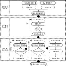
Fig. 1
ALB installation angle deviation calibration process"


Fig. 2
ALB bathymetric laser transmission path"
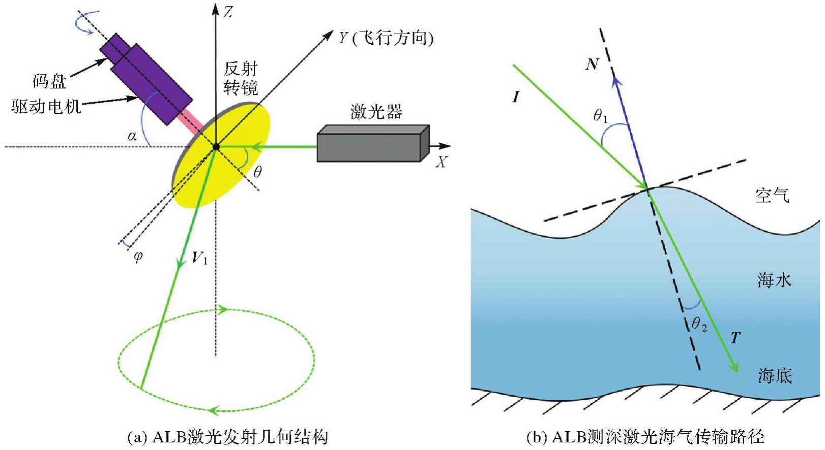
Fig. 3
Road stratification caused by pitch angle error"
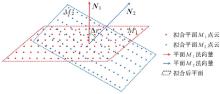
Fig. 4
Position offset caused by roll angle error"
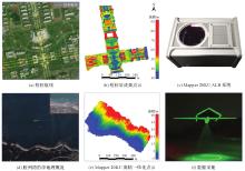
Fig. 5
Overview of data acquisition experiment"

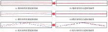
Fig. 6
Road profile point cloud before and after calibration"
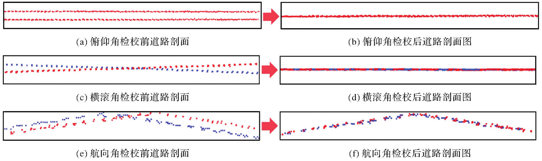

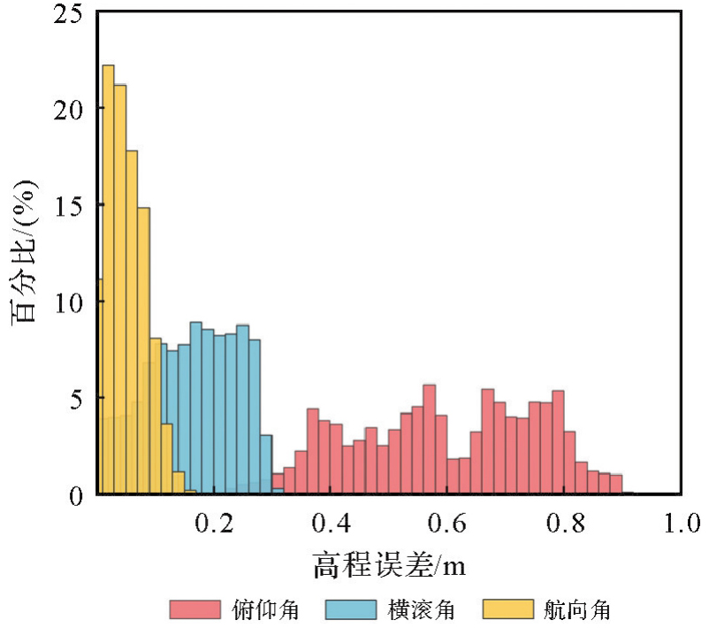
Fig. 7
Analysis of elevation differences due to different installation angles"
Tab. 1
Comparison of internal conformance accuracy for Mapper 20KU"
| 方法 | 对比同名点数 | 最大值/cm | 最小值/cm | MAE/cm | RMSE/cm |
|---|---|---|---|---|---|
| 本文算法(无控制点) | 150 | 7.1 | 0.1 | 2.4 | 4.2 |
| 有控制点算法 | 150 | 6.8 | 0.1 | 2.2 | 4.1 |
Fig. 8
Mapper 20KU relative distribution of positions compared with RTK and SBES points"
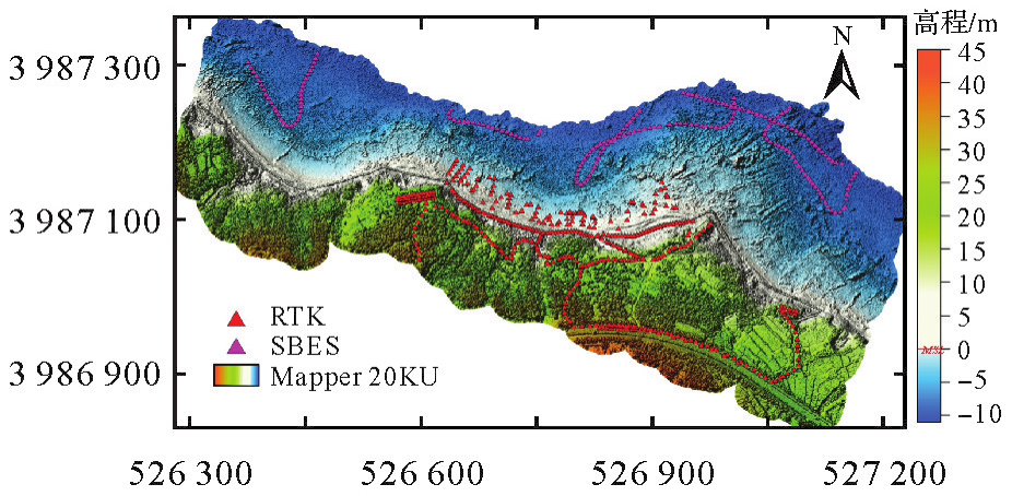
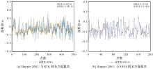
Fig. 9
Distribution chart of elevation differences between Mapper 20KU and validation data homonymous points"

Tab. 2
Comparison of external conformance accuracy for Mapper 20KU"
| 精度对比 | 对比同名点数 | 方法 | 最大值/cm | 最小值/cm | MAE/cm | RMSE/cm |
|---|---|---|---|---|---|---|
| 陆地点云 (与RTK对比) | 493 | 有控制点算法 本文算法(无控制点) | 18.3 | 0.1 | 6.2 | 8.0 |
| 17.9 | 0.1 | 6.5 | 8.1 | |||
| 水下点云 (与SBES对比) | 197 | 有控制点算法 本文算法(无控制点) | 27.1 | 0.1 | 11.2 | 13.2 |
| 27.6 | 0.1 | 11.5 | 13.4 |
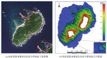
Fig. 10
Post-calibration point cloud of Fenjiezhou island, Lingshui li autonomous county, Hainan province"

| [1] |
翟国君, 黄谟涛. 海洋测量技术研究进展与展望[J]. 测绘学报, 2017, 46(10): 1752-1759. DOI: .
doi: 10.11947/j.AGCS.2017.20170309 |
|
ZHAI Guojun, HUANG Motao. The review of development of marine surveying technology[J]. Acta Geodaetica et Cartographica Sinica, 2017, 46(10): 1752-1759. DOI: .
doi: 10.11947/j.AGCS.2017.20170309 |
|
| [2] | 黄谟涛, 翟国君, 欧阳永忠, 等. 机载激光测深中的波浪改正技术[J]. 武汉大学学报(信息科学版), 2003, 28(4): 389-392. |
| HUANG Motao, ZHAI Guojun, OUYANG Yongzhong, et al. Wave correction in airborne laser hydrography[J]. Geomatics and Information Science of Wuhan University, 2003, 28(4): 389-392. | |
| [3] |
宿殿鹏. 机载LiDAR测深数据处理关键技术研究[J]. 测绘学报, 2022, 51(3): 473. DOI: .
doi: 10.11947/j.AGCS.2022.20200542 |
|
SU Dianpeng. Key technologies for processing airborne LiDAR bathymetry[J]. Acta Geodaetica et Cartographica Sinica, 2022, 51(3): 473. DOI: .
doi: 10.11947/j.AGCS.2022.20200542 |
|
| [4] |
丁凯, 李清泉, 朱家松, 等. 运用MODIS遥感数据评测南海北部区域机载激光雷达测深系统参数[J]. 测绘学报, 2018, 47(2): 180-187. DOI: .
doi: 10.11947/j.AGCS.2018.20170536 |
|
DING Kai, LI Qingquan, ZHU Jiasong, et al. Evaluation of airborne LiDAR bathymetric parameters on the Northern South China Sea based on MODIS data[J]. Acta Geodaetica et Cartographica Sinica, 2018, 47(2): 180-187. DOI: .
doi: 10.11947/j.AGCS.2018.20170536 |
|
| [5] | 刘焱雄, 郭锴, 何秀凤, 等. 机载激光测深技术及其研究进展[J]. 武汉大学学报(信息科学版), 2017, 42(9): 1185-1194. |
| LIU Yanxiong, GUO Kai, HE Xiufeng, et al. Research progress of airborne laser bathymetry technology[J]. Geomatics and Information Science of Wuhan University, 2017, 42(9): 1185-1194. | |
| [6] | 亓超, 周丰年, 吴敬文, 等. 基于机载LiDAR测深水体波形的漫衰减系数提取方法[J]. 海洋学报, 2021, 43(1): 147-154. |
| QI Chao, ZHOU Fengnian, WU Jingwen, et al. Extraction method for diffuse attenuation coefficient based on airborne LiDAR bathymetric water column waveform[J]. Haiyang Xuebao, 2021, 43(1): 147-154. | |
| [7] |
王丹菂, 徐青, 邢帅, 等. 机载激光测深近水面渗透误差修正的半经验波形分解方法[J]. 测绘学报, 2023, 52(6): 944-955. DOI: .
doi: 10.11947/j.AGCS.2023.20210603 |
|
WANG Dandi, XU Qing, XING Shuai, et al. Semi-empirical waveform decomposition method for correction of near water surface penetration error in airborne LiDAR bathymetry[J]. Acta Geodaetica et Cartographica Sinica, 2023, 52(6): 944-955. DOI: .
doi: 10.11947/j.AGCS.2023.20210603 |
|
| [8] | YANG Fanlin, QI Chao, SU Dianpeng, et al. An airborne LiDAR bathymetric waveform decomposition method in very shallow water: a case study around Yuanzhi Island in the South China Sea[J]. International Journal of Applied Earth Observation and Geoinformation, 2022, 109: 102788. |
| [9] | 亓超, 宿殿鹏, 阳凡林, 等. 机载LiDAR测深中海底地形坡度的影响及改正[J]. 遥感学报, 2022, 26(12): 2642-2654. |
| QI Chao, SU Dianpeng, YANG Fanlin, et al. Analysis and correction in the airborne LiDAR bathymetric error caused by the effect of seafloor topography slope[J]. National Remote Sensing Bulletin, 2022, 26(12): 2642-2654. | |
| [10] |
申二华, 张永生, 李凯. 圆扫描式机载激光测深系统检校模型及仿真分析[J]. 测绘学报, 2016, 45(8): 943-951. DOI: .
doi: 10.11947/j.AGCS.2016.20150532 |
|
SHEN Erhua, ZHANG Yongsheng, LI Kai. The calibration model and simulation analysis of circular scanning airborne laser bathymetry system[J]. Acta Geodaetica et Cartographica Sinica, 2016, 45(8): 943-951. DOI: .
doi: 10.11947/j.AGCS.2016.20150532 |
|
| [11] | LI Xingxing, ZHANG Xiaohong, NIU Xiaoji, et al. Progress and achievements of multi-sensor fusion navigation in China during 2019—2023[J]. Journal of Geodesy and Geoinformation Science, 2023, 6(3): 102-114. |
| [12] | 姚连璧, 汪志飞, 孙海丽. 车载激光扫描仪外参数标定方法设计与实现[J]. 同济大学学报(自然科学版), 2016, 44(1): 161-166. |
| YAO Lianbi, WANG Zhifei, SUN Haili. Design and implementation of vehicle laser scanner's external parameter calibration[J]. Journal of Tongji University (Natural Science), 2016, 44(1): 161-166. | |
| [13] | 郭恒林, 景冬, 卢秀山, 等. 经纬仪工业测量系统在标定圆形GNSS天线中的应用[J]. 测绘工程, 2021, 30(6): 56-59. |
| GUO Henglin, JING Dong, LU Xiushan, et al. Application of the odolite industrial measurement system to calibrating circular GNSS antenna[J]. Engineering of Surveying and Mapping, 2021, 30(6): 56-59. | |
| [14] | GLENNIE C, LICHTI D D. Static calibration and analysis of the velodyne HDL-64E S2 for high accuracy mobile scanning[J]. Remote Sensing, 2010, 2(6): 1610-1624. |
| [15] | 俞家勇, 程烺, 田茂义, 等. 基于参考面约束的车载移动测量系统安置参数检校方法[J]. 红外与激光工程, 2020, 49(7): 20190524. |
| YU Jiayong, CHENG Lang, TIAN Maoyi, et al. Boresight parameters calibration method of VMLS system based on reference planar features constraint[J]. Infrared and Laser Engineering, 2020, 49(7): 20190524. | |
| [16] | 张小红. 机载激光雷达测量技术理论与方法[M]. 武汉: 武汉大学出版社, 2007. |
| ZHANG Xiaohong. Theory and method of airborne LiDAR measurement technology[M]. Wuhan: Wuhan University Press, 2007. | |
| [17] | HABIB A F, KERSTING A P, RUIFANG Z, et al. LiDAR strip adjustment using conjugate linear features in overlapping strips[J]. Proceedings of International Archives of the Photogrammetry, Remote Sensing and Spatial Information Sciences, 2008: 385-390. |
| [18] | 胡国军, 朱精果, 刘汝卿. Mars-LiDAR系统误差分析及安置角误差飞行检校[J]. 红外与激光工程, 2016, 45(12): 1217009. |
| HU Guojun, ZHU Jingguo, LIU Ruqing. Error analysis of Mars-LiDAR system and calibration of installation angle error[J]. Infrared and Laser Engineering, 2016, 45(12): 1217009. | |
| [19] | 张靖, 江万寿, 姜三. 基于虚拟点模型的机载LiDAR系统自动检校方法[J]. 测绘学报, 2013, 42(3): 389-396. |
| ZHANG Jing, JIANG Wanshou, JIANG San. Automated airborne LiDAR system calibration using virtual tie point model[J]. Acta Geodaetica et Cartographica Sinica, 2013, 42(3): 389-396. | |
| [20] | PUSZTAI Z, EICHHARDT I, HAJDER L. Accurate calibration of multi-LiDAR-multi-camera systems[J]. Sensors, 2018, 18(7): 2139. |
| [21] | 陈洁, 肖春蕾, 李京. 无检校场的机载LiDAR点云数据检校方法[J]. 国土资源遥感, 2015, 27(4): 27-33. |
| CHEN Jie, XIAO Chunlei, LI Jing. Calibration of airborne LiDAR cloud point data with no calibration field[J]. Remote Sensing for Land & Resources, 2015, 27(4): 27-33. | |
| [22] | 李伟, 唐伶俐, 吴昊昊, 等. 轻小型无人机载激光雷达系统研制及电力巡线应用[J]. 遥感技术与应用, 2019, 34(2): 269-274. |
| LI Wei, TANG Lingli, WU Haohao, et al. Development of mini UAV-borne LiDAR system and it's application of power line inspection[J]. Remote Sensing Technology and Application, 2019, 34(2): 269-274. | |
| [23] | GONSALVES M O. A comprehensive uncertainty analysis and method of geometric calibration for a circular scanning airborne LiDAR[M]. Mississippi: The University of Southern Mississippi, 2010. |
| [24] | 王致华, 张爱武, 王书民, 等. 基于重叠航带的机载激光雷达系统检校[J]. 中国激光, 2014, 41(2): 214003. |
| WANG Zhihua, ZHANG Aiwu, WANG Shumin, et al. Airborne radar calibration system based on the overlap strip[J]. Chinese Journal of Lasers, 2014, 41(2): 214003. | |
| [25] | 黎东, 王成, 习晓环, 等. 共面约束的机载LiDAR IMU安置角误差自动检校方法[J]. 测绘科学, 2017, 42(9): 98-103. |
| LI Dong, WANG Cheng, XI Xiaohuan, et al. An automatic bore-sight calibration method for airborne LiDAR based on co-planar constrains[J]. Science of Surveying and Mapping, 2017, 42(9): 98-103. | |
| [26] | 杨书娟, 张珂殊, 邵永社. 机载激光雷达系统的航带平差法[J]. 中国激光, 2017, 44(12): 1210003. |
| YANG Shujuan, ZHANG Keshu, SHAO Yongshe. Strip adjustment method for airborne LiDAR system[J]. Chinese Journal of Lasers, 2017, 44(12): 1210003. | |
| [27] | 贺岩, 陶邦一, 俞家勇, 等. 机载激光测深技术及应用[J]. 中国激光, 2024, 51(11): 1101016. |
| HE Yan, TAO Bangyi, YU Jiayong, et al. Development of airborne LiDAR bathymetric technology and application[J]. Chinese Journal of Lasers, 2024, 51(11): 1101016. | |
| [28] | 俞家勇, 卢秀山, 田茂义, 等. 机载激光雷达测深系统定位模型与视准轴误差影响分析[J]. 红外与激光工程, 2019, 48(6): 0606005. |
| YU Jiayong, LU Xiushan, TIAN Maoyi, et al. Effect analysis of positioning model and boresight error analysis of airborne LiDAR bathymetry system[J]. Infrared and Laser Engineering, 2019, 48(6): 0606005. | |
| [29] | 王显军. 光电轴角编码器细分信号误差及精度分析[J]. 光学精密工程, 2012, 20(2): 379. |
| WANG Xianjun. Errors and precision analysis of subdivision signals for photoelectric angle encoders[J]. Optics and Precision Engineering, 2012, 20(2): 379. | |
| [30] | DU Libin, CUI Tong, MENG Xiangqian, et al. Analysis of scanning systematic errors for airborne laser bathymetry[J]. Applied Optics, 2023, 62(26): 6939-6951. |
| [31] |
宿殿鹏, 闫豆豆, 陈亮, 等. 机载LiDAR测深点云SVB联合滤波算法[J]. 测绘学报, 2023, 52(4): 614-623. DOI: .
doi: 10.11947/j.AGCS.2023.20220248 |
|
SU Dianpeng, YAN Doudou, CHEN Liang, et al. Surface-volume-bottom joint-filtering algorithm for airborne LiDAR bathymetric point cloud[J]. Acta Geodaetica et Cartographica Sinica, 2023, 52(4): 614-623. DOI: .
doi: 10.11947/j.AGCS.2023.20220248 |
|
| [32] | XU Wenxue, GUO Kai, LIU Yanxiong, et al. Refraction error correction of airborne LiDAR bathymetry data considering sea surface waves[J]. International Journal of Applied Earth Observation and Geoinformation, 2021, 102: 102402. |
| [33] | QUAN X, FRY E S. Empirical equation for the index of refraction of seawater[J]. Applied Optics, 1995, 34(18): 3477-3480. |
| [1] | Dongdong PU, Hongzhou CHAI, Yongzhong OUYANG, Chao DONG. Hierarchical encryption matching algorithm for adjacent strip splicing in airborne LiDAR bathymetry [J]. Acta Geodaetica et Cartographica Sinica, 2025, 54(8): 1439-1451. |
| [2] | WANG Dandi, XU Qing, XING Shuai, LIN Yuzhun, ZHANG Guoping. Semi-empirical waveform decomposition method for correction of near water surface penetration error in airborne LiDAR bathymetry [J]. Acta Geodaetica et Cartographica Sinica, 2023, 52(6): 944-955. |
| [3] | SU Dianpeng, YAN Doudou, CHEN Liang, CHEN Yu, DONG Jian, WU Di, YU Xiaolin. Surface-volume-bottom joint-filtering algorithm for Airborne LiDAR bathymetric point cloud [J]. Acta Geodaetica et Cartographica Sinica, 2023, 52(4): 614-623. |
| [4] | WANG Dandi, XING Shuai, XU Qing, LIN Yuzhun, LI Pengcheng. Automatic sea-land waveform classification method for single-wavelength airborne LiDAR bathymetry [J]. Acta Geodaetica et Cartographica Sinica, 2022, 51(5): 750-761. |
| [5] | WANG Dandi, XU Qing, XING Shuai, LIN Yuzhun, LI Pengcheng. A Coarse-to-fine Signal Detection Method for Airborne LiDAR Bathymetry [J]. Acta Geodaetica et Cartographica Sinica, 2018, 47(8): 1148-1159. |
| [6] | DING Kai, LI Qingquan, ZHU Jiasong, WANG Chisheng, GUAN Minglei, CUI Yang, YANG Chao, XU Tian. Evaluation of Airborne LiDAR Bathymetric Parameters on the Northern South China Sea Based on MODIS Data [J]. Acta Geodaetica et Cartographica Sinica, 2018, 47(2): 180-187. |
| [7] | WANG Dandi, XU Qing, XING Shuai, LIN Yuzhun, LI Pengcheng. Comparison of Signal Extraction Method for Airborne LiDAR Bathymetry Based on Deconvolution [J]. Acta Geodaetica et Cartographica Sinica, 2018, 47(2): 161-169. |
| Viewed | ||||||
|
Full text |
|
|||||
|
Abstract |
|
|||||