

Acta Geodaetica et Cartographica Sinica ›› 2025, Vol. 54 ›› Issue (8): 1452-1463.doi: 10.11947/j.AGCS.2025.20240459
• Marine Survey • Previous Articles Next Articles
Yijie ZHAO( ), Junting WANG(), Tianhe XU, Jianxu SHU, Yangfan LIU
Received:2024-11-18
Revised:2025-07-07
Online:2025-09-16
Published:2025-09-16
Contact:
Junting WANG
E-mail:zhaoyjnice@163.com;wjtsci2015@163.com
About author:ZHAO Yijie (2001—), male, postgraduate, majors in underwater acoustic positioning and multi-sensor integrated navigation. E-mail: zhaoyjnice@163.com
CLC Number:
Yijie ZHAO, Junting WANG, Tianhe XU, Jianxu SHU, Yangfan LIU. Correction method for time-varying sound speed errors in underwater geodetic datum positioning[J]. Acta Geodaetica et Cartographica Sinica, 2025, 54(8): 1452-1463.
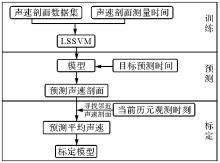
Fig. 1
The flowchart of predicting acoustic velocity profile using LSSVM"
Tab. 1
Measured sound speed profile information"
| 声速剖面 | 测量开始时间 | 最大深度/m |
|---|---|---|
| SSP1 | 08-30 15:57 | 2921 |
| SSP2 | 23:58 09-02 | 3408 |
| SSP3 | 09-05 05:04 | 2983 |
| SSP4 | 09-06 13:32 | 2803 |
| SSP5 | 09-07 06:20 | 2787 |
| SSP6 | 09-10 07:58 | 2615 |
| SSP7 | 09-11 06:41 | 2504 |
| SSP8 | 09-12 01:29 | 3387 |
| SSP9 | 09-12 09:28 | 2978 |
| SSP10 | 09-14 10:16 | 2586 |
| SSP11 | 09-16 06:29 | 2811 |
| SSP12 | 09-17 23:59 | 3107 |
| SSP13 | 09-18 04:34 | 3086 |

Fig. 2
Extended sound speed profile"
Tab. 2
Extension results"
| 声速剖面 | EOF-PSSP-ME | EOF |
|---|---|---|
| SSP1 | 0.375 5 | 0.810 1 |
| SSP3 | 0.761 6 | 0.920 8 |
| SSP4 | 0.583 2 | 0.562 8 |
| SSP5 | 0.591 0 | 0.655 8 |
| SSP6 | 0.431 8 | 0.813 1 |
| SSP7 | 0.390 8 | 0.962 8 |
| SSP9 | 0.662 5 | 1.305 2 |
| SSP10 | 0.834 1 | 1.183 7 |
| SSP11 | 0.483 4 | 1.360 9 |
| SSP12 | 0.696 2 | 1.133 5 |
| SSP13 | 0.733 7 | 1.629 3 |
| 平均RMS | 0.594 6 | 1.031 7 |
Tab. 3
LSSVM prediction accuracy of SSP"
| 声速剖面 | RMS |
|---|---|
| SSP1 | 0.959 8 |
| SSP2 | 0.551 2 |
| SSP3 | 0.052 4 |
| SSP4 | 0.631 5 |
| SSP5 | 0.775 1 |
| SSP6 | 0.260 1 |
| SSP7 | 0.324 7 |
| SSP8 | 0.745 8 |
| SSP9 | 0.228 2 |
| SSP10 | 1.176 9 |
| SSP11 | 0.482 6 |
| SSP12 | 0.717 8 |
| SSP13 | 0.395 1 |
| 平均RMS | 0.561 6 |
Fig. 3
Predicted values and true values of SSP6"
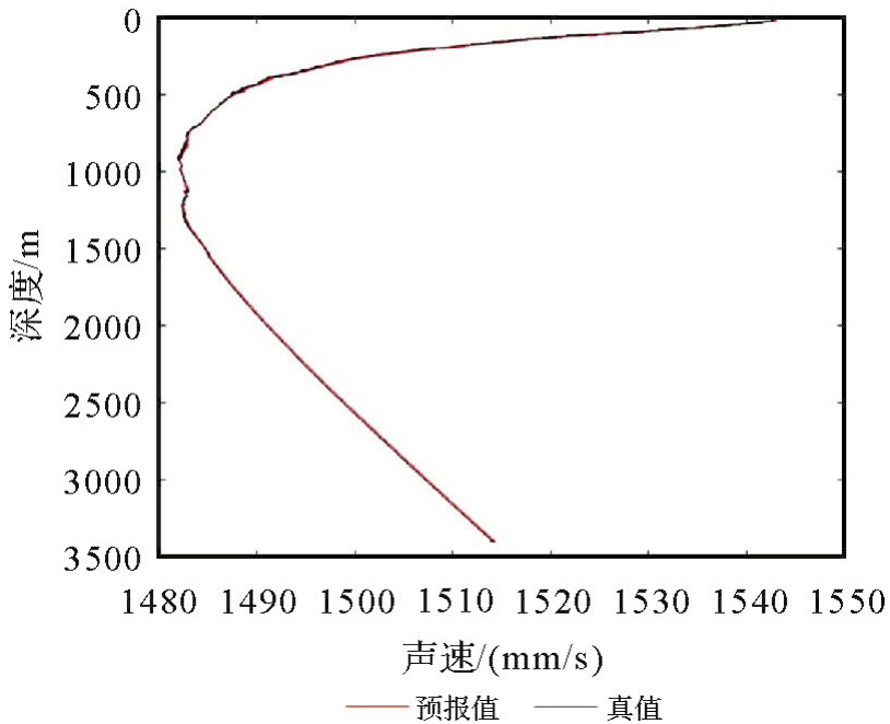
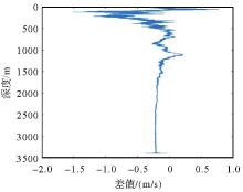
Fig. 4
Difference of SSP6"
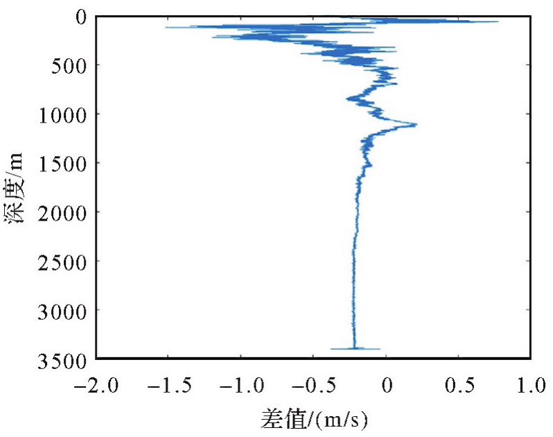
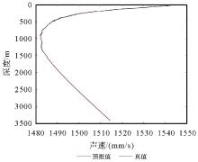
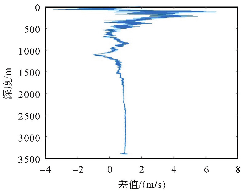
Fig. 5
Predicted values and true values of SSP10"
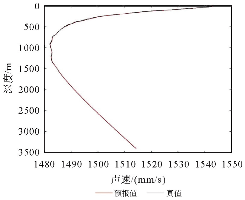
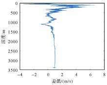
Fig. 6
Difference of SSP10"
Tab. 4
Sample selection"
| 试验 | 样本和测量时间 |
|---|---|
| 4条样本 | SSP13(04:34)、SSP10(10:16)、SSP1(15:57)、SSP12(23:59) |
| 7条样本 | SSP8(01:29)、SSP3(05:04)、SSP6(07:58)、SSP10(10:16)、SSP4(13:32)、SSP1(15:57)、SSP2(23:58) |
Tab. 5
Experimental results of 4 samples"
| 验证样本 | RMS |
|---|---|
| SSP2 | 0.229 1 |
| SSP3 | 0.853 9 |
| SSP4 | 1.031 6 |
| SSP5 | 0.874 8 |
| SSP6 | 0.888 4 |
| SSP7 | 0.882 1 |
| SSP8 | 0.845 5 |
| SSP9 | 0.985 0 |
| SSP11 | 0.877 7 |
| 平均RMS | 0.829 8 |
Tab. 6
Experimental results of 7 samples"
| 验证样本 | RMS |
|---|---|
| SSP5 | 0.546 8 |
| SSP7 | 0.594 2 |
| SSP9 | 0.776 4 |
| SSP11 | 0.558 3 |
| SSP12 | 1.165 3 |
| SSP13 | 0.411 6 |
| 平均RMS | 0.675 4 |
Tab. 7
The results of 3rd-order polynomial fitting"
| 声速剖面 | RMS |
|---|---|
| SSP1 | 0.351 0 |
| SSP2 | 1.061 1 |
| SSP3 | 0.921 2 |
| SSP4 | 0.285 1 |
| SSP5 | 0.526 4 |
| SSP6 | 1.110 9 |
| SSP7 | 0.785 9 |
| SSP8 | 0.358 8 |
| SSP9 | 0.338 3 |
| SSP10 | 0.083 |
| SSP11 | 0.063 2 |
| SSP12 | 1.095 7 |
| SSP13 | 0.989 3 |
| 平均RMS | 0.613 1 |
Tab. 8
The results of 4th-order polynomial fitting"
| 声速剖面 | RMS |
|---|---|
| SSP1 | 0.742 0 |
| SSP2 | 1.077 4 |
| SSP3 | 0.924 3 |
| SSP4 | 0.370 2 |
| SSP5 | 0.491 3 |
| SSP6 | 1.089 9 |
| SSP7 | 0.765 7 |
| SSP8 | 1.979 8 |
| SSP9 | 0.265 7 |
| SSP10 | 0.290 4 |
| SSP11 | 0.100 8 |
| SSP12 | 1.074 5 |
| SSP13 | 1.306 7 |
| 平均RMS | 0.805 4 |
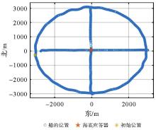
Fig. 7
Positioning trajectory of geodetic datum 1"
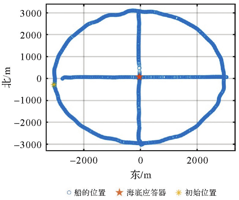
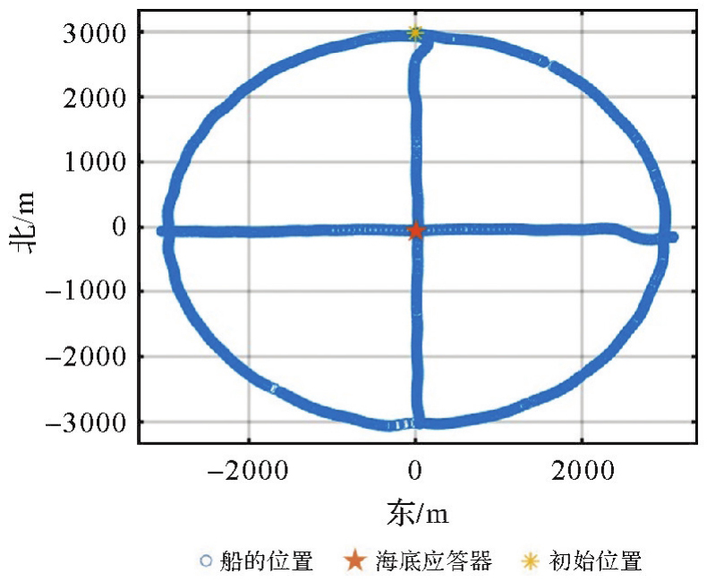
Fig. 8
Positioning trajectory of geodetic datum 2"
Tab. 9
Positioning data time period and prediction time of SSP"
| 测段 | SSP预测时间 | |
|---|---|---|
| 基准点1 | 15:30-18:40 18:50-19:50 20:40-21:50 | 15:45、16:15、17:15、17:45、18:15、18:45、19:00、19:30、21:00、21:30 |
| 基准点2 | 9:20-13:45 14:35-15:40 | 9:30、10:00、10:30、11:00、11:30、12:00、12:30、13:00、13:30、15:00、15:30 |
Tab. 10
Positioning results"
| 测站 | 方法 | X/m | Y/m | Z/m | ΔX/m | ΔY/m | ΔZ/m | Sigma-X | Sigma-Y | Sigma-Z |
|---|---|---|---|---|---|---|---|---|---|---|
| 测站1 | 声线跟踪 | -2 674 347.480 | 5 417 451.158 | 2 026 714.051 | — | — | 0.017 | 0.017 | 0.009 | |
| 加权平均声速A | -2 674 346.939 | 5 417 449.993 | 2 026 713.370 | -0.541 | 1.165 | 0.681 | 0.015 | 0.017 | 0.007 | |
| 加权平均声速B | -2 674 347.607 | 5 417 450.634 | 2 026 713.551 | 0.127 | 0.524 | 0.499 | 0.015 | 0.017 | 0.007 | |
| 测站2 | 声线跟踪 | -2 675 608.492 | 5 414 476.353 | 2 033 908.222 | — | — | 0.023 | 0.023 | 0.013 | |
| 加权平均声速A | -2 675 607.774 | 5 414 475.005 | 2 033 907.718 | -0.718 | 1.348 | 0.504 | 0.024 | 0.023 | 0.011 | |
| 加权平均声速B | -2 675 608.668 | 5 414 476.631 | 2 033 908.203 | 0.176 | -0.277 | 0.019 | 0.040 | 0.038 | 0.019 |
Tab. 11
2D and 3D positioning accuracy"
| 测站 | 方法 | 2D坐标差 | 提升/(%) | 3D坐标差 | 提升/(%) | 2D-Sigma | 3D-Sigma |
|---|---|---|---|---|---|---|---|
| 测站1 | 加权平均声速A | 0.908 | — | 0.839 | — | 0.017 | 0.015 |
| 加权平均声速B | 0.381 | 58 | 0.424 | 49.5 | 0.016 | 0.014 | |
| 测站2 | 加权平均声速A | 1.080 | — | 0.928 | — | 0.024 | 0.020 |
| 加权平均声速B | 0.232 | 78.5 | 0.190 | 79.5 | 0.039 | 0.034 |
Tab. 12
The positioning difference circular and cross-shaped trajectories"
| 测站 | 方法 | 2D标定互差 | 提升/(%) | 3D标定互差 | 提升/(%) |
|---|---|---|---|---|---|
| 测站1 | 加权平均声速A | 0.629 | — | 0.839 | — |
| 加权平均声速B | 0.363 | 42.2 | 0.364 | 56.6 | |
| 测站2 | 加权平均声速A | 0.804 | — | 0.847 | — |
| 加权平均声速B | 0.658 | 18.1 | 0.667 | 21.3 |
| [1] | 刘经南, 陈冠旭, 赵建虎, 等. 海洋时空基准网的进展与趋势[J]. 武汉大学学报(信息科学版), 2019, 44(1): 17-37. |
| LIU Jingnan, CHEN Guanxu, ZHAO Jianhu, et al. Development and trends of marine space-time frame network[J]. Geomatics and Information Science of Wuhan University, 2019, 44(1): 17-37. | |
| [2] | 孙大军, 郑翠娥. 水声导航、定位技术发展趋势探讨[J]. 海洋技术, 2015(3): 64-68. |
| SUN Dajun, ZHENG Cuie. Study on the development trend of underwater acoustic navigation and positioning technologies[J]. Ocean Technology, 2015(3): 64-68. | |
| [3] |
党亚民, 蒋涛, 杨元喜, 等. 中国大地测量研究进展(2019—2023)[J]. 测绘学报, 2023, 52(9): 1419-1436. DOI: .
doi: 10.11947/j.AGCS.2023.20230343 |
|
DANG Yamin, JIANG Tao, YANG Yuanxi, et al. Research progress of geodesy in China (2019—2023)[J]. Acta Geodaetica et Cartographica Sinica, 2023, 52(9): 1419-1436. DOI: .
doi: 10.11947/j.AGCS.2023.20230343 |
|
| [4] |
杨元喜, 徐天河, 薛树强. 我国海洋大地测量基准与海洋导航技术研究进展与展望[J]. 测绘学报, 2017, 46(1): 1-8. DOI: .
doi: 10.11947/j.AGCS.2017.20160519 |
|
YANG Yuanxi, XU Tianhe, XUE Shuqiang. Progresses and prospects in developing marine geodetic datum and marine navigation of China[J]. Acta Geodetica et Cartographica Sinica, 2017, 46(1): 1-8. DOI: .
doi: 10.11947/j.AGCS.2017.20160519 |
|
| [5] | 吴永亭. LBL精密定位理论方法研究及软件系统研制[D]. 武汉: 武汉大学, 2013. |
| WU Yongting. Study on theory and method of precise LBL positioning and development of positioning software system[D]. Wuhan: Wuhan University, 2013. | |
| [6] | 郭颖. 长基线导航优化算法研究与软件实现[D]. 哈尔滨: 哈尔滨工程大学, 2019. |
| GUO Ying. Research and software implementation of long baseline navigation optimization algorithm[D]. Harbin: Harbin Engineering University, 2019. | |
| [7] | 桑金. 水深测量中的声速改正问题研究[J]. 海洋测绘, 2006, 26(3): 17-20. |
| SANG Jin. Sound velocity correction and depth reduction in sounding[J]. Hydrographic Surveying and Charting, 2006, 26(3): 17-20. | |
| [8] | WANG Junting, XU Tianhe, LIU Yangfan, et al. Kalman filter based acoustic positioning of deep seafloor datum point with two-step systematic error estimation[J]. Applied Ocean Research, 2021, 114: 102817. |
| [9] | 刘杨范. 水声定位中声速改正算法研究[D]. 青岛: 中国石油大学(华东), 2020. |
| LIU Yangfan. Research on sound speed correction algorithm in underwater acoustic positioning[D]. Qingdao: China University of Petroleum (East China), 2020. | |
| [10] | CHEN H H. Travel-time approximation of acoustic ranging in GPS/acoustic seafloor geodesy[J]. Ocean Engineering, 2014, 84: 133-144. |
| [11] | LI Zhao, DOSSO S E, SUN Dajun. Joint inversion for transponder localization and sound-speed profile temporal variation in high-precision acoustic surveys[J]. The Journal of the Acoustical Society of America, 2016, 140(1): EL44-EL49. |
| [12] | 王君婷. 海洋精密声学数据处理理论与方法研究[D]. 威海: 山东大学, 2023. |
| WANG Junting. Research on theory and method of marine precise acoustic data processing[D]. Weihai: Shandong University, 2023. | |
| [13] | 周士弘, 张茂有, 周日鹏. 海洋声速场的经验正交函数描述及声速剖面预报[J]. 海洋通报, 1999, 18(5): 27-34. |
| ZHOU Shihong, ZHANG Maoyou, ZHOU Ripeng. Study on empirical orthogonal functions expression and prediction of the sound speed field[J]. Marine Science Bulletin, 1999, 18(5): 27-34. | |
| [14] | 艾锐峰, 程杰, 欧阳军, 等. 海区声速剖面的现场反演方法[J]. 计算机应用, 2015, 35(): 327-330, 338. |
| AI Ruifeng, CHENG Jie, OUYANG Jun, et al. On-line retrieval methodology for sound speed profile of sea area[J]. Journal of Computer Applications, 2015, 35(): 327-330, 338. | |
| [15] | HUANG Wei, LU Jiajun, LI Sijia, et al. Fast estimation of full depth sound speed profile based on partial prior information[C]//Proceedings of 2023 IEEE International Conference on Electronic Information and Communication Technology. Qingdao: IEEE, 2023: 479-484. |
| [16] | VALIZADEH M, SMILEY E, BRAKI Z A, et al. Smart spectrophotometric approach for the simultaneous determination of anti-asthma drugs in inhalation spray using least squares support vector machine and net analyte signal[J]. Optik, 2022, 258: 168816. |
| [17] | 刘靖宇. 基于支持向量机的工业物联网入侵检测研究[D]. 沈阳: 中国科学院大学(中国科学院沈阳计算技术研究所), 2021. |
| LIU Jingyu. Research on intrusion detection of industrial internet of things based on support vector machine[D]. Shenyang: University of Chinese Academy of Sciences (Shenyang Institute of Computing Technology, Chinese Academy of Sciences), 2021. | |
| [18] | IKUTA R, TADOKORO K, ANDO M, et al. A new GPS-acoustic method for measuring ocean floor crustal deformation: application to the Nankai Trough[J]. Journal of Geophysical Research: Solid Earth, 2008, 113(B2): B02401. |
| [19] | YASUDA K, TADOKORO K, TANIGUCHI S, et al. Interplate locking condition derived from seafloor geodetic observation in the shallowest subduction segment at the Central Nankai Trough, Japan[J]. Geophysical Research Letters, 2017, 44(8): 3572-3579. |
| [20] | CHEN H Y, IKUTA R, LIN C H, et al. Back-arc opening in the western end of the Okinawa trough revealed from GNSS/acoustic measurements[J]. Geophysical Research Letters, 2018, 45(1): 137-145. |
| [21] | HONSHO C, KIDO M. Comprehensive analysis of traveltime data collected through GPS-acoustic observation of seafloor crustal movements[J]. Journal of Geophysical Research: Solid Earth, 2017, 122(10): 8583-8599. |
| [22] | KIDO M. Detecting horizontal gradient of sound speed in ocean[J]. Earth, Planets and Space, 2007, 59(8): e33-e36. |
| [23] | KIDO M, OSADA Y, FUJIMOTO H. Temporal variation of sound speed in ocean: a comparison between GPS/acoustic and in situ measurements[J]. Earth, Planets and Space, 2008, 60(3): 229-234. |
| [24] | TOMITA F, KIDO M, HONSHO C, et al. Development of a kinematic GNSS-acoustic positioning method based on a state-space model[J]. Earth, Planets and Space, 2019, 71(1): 102. |
| [25] | HONSHO C, KIDO M, TOMITA F, et al. Offshore postseismic deformation of the 2011 Tohoku Earthquake revisited: application of an improved GPS-acoustic positioning method considering horizontal gradient of sound speed structure[J]. Journal of Geophysical Research: Solid Earth, 2019, 124(6): 5990-6009. |
| [26] | WANG Junting, XU Tianhe, ZHANG Bingsheng, et al. Underwater acoustic positioning based on the robust zero-difference Kalman filter[J]. Journal of Marine Science and Technology, 2021, 26(3): 734-749. |
| [27] | WANG Junting, XU Tianhe, LIU Yangfan, et al. Kalman filter based acoustic positioning of deep seafloor datum point with two-step systematic error estimation[J]. Applied Ocean Research, 2021, 114: 102817. |
| [28] | QIN Xianping, YANG Yuanxi, SUN Bijiao. The refined resilient model for underwater acoustic positioning[J]. Ocean Engineering, 2022, 266: 112795. |
| [29] | YANG Yuanxi, QIN Xianping. Resilient observation models for seafloor geodetic positioning[J]. Journal of Geodesy, 2021, 95(7): 79. |
| [30] | LI Zhenglin, HE Li, ZHANG Renhe, et al. Sound speed profile inversion using a horizontal line array in shallow water[J]. Science China Physics, Mechanics & Astronomy, 2015, 58(10): 104321. |
| [31] | 王燚, 郭伟. 基于最小二乘SVM的混沌跳频通信码预测方法[J]. 电子测量与仪器学报, 2007, 21(5): 64-68. |
| WANG Yi, GUO Wei. Chaotic-FH code prediction method based on LS-SVM[J]. Journal of Electronic Measurement and Instrumentation, 2007, 21(5): 64-68. | |
| [32] | 舒建旭. 高精度海底基准点标定与长基线水声导航算法研究[D]. 西安: 长安大学, 2023. |
| SHU Jianxu. Study on algorithm of precise marine geodetic datum positioning and long baseline underwater acoustic navigation[D]. Xi'an: Chang'an University, 2023. | |
| [33] |
曾安敏, 杨元喜, 明锋, 等. 海底大地基准点圆走航模式定位模型及分析[J]. 测绘学报, 2021, 50(7): 939-952. DOI: .
doi: 10.11947/j.AGCS2021.20200529 |
|
ZENG Anmin, YANG Yuanxi, MING Feng, et al. Positioning model and analysis of the sailing circle mode of seafloor geodetic datum points[J]. Acta Geodaetica et Cartographica Sinica, 2021, 50(7): 939-952. DOI: .
doi: 10.11947/j.AGCS2021.20200529 |
| [1] | CHEN Guanxu, GAO Kefu, ZHAO Jianhu, LIU Jingnan, LIU Yanxiong, LIU Yang, LI Menghao. The method of sound speed errors correction in GNSS-acoustic location service [J]. Acta Geodaetica et Cartographica Sinica, 2023, 52(4): 536-549. |
| Viewed | ||||||
|
Full text |
|
|||||
|
Abstract |
|
|||||