

Acta Geodaetica et Cartographica Sinica ›› 2026, Vol. 55 ›› Issue (1): 73-89.doi: 10.11947/j.AGCS.2026.20250218
• Geodesy and Navigation • Previous Articles Next Articles
Dongliang CHENG1( ), Lingqiu CHEN1,2(), Zhiyong HUANG3, Shubo QIAO1,2, Dandan WANG1, Yaming YAN1
Received:2025-05-27
Revised:2025-12-25
Online:2026-02-13
Published:2026-02-13
Contact:
Lingqiu CHEN
E-mail:061416125@huuc.edu.cn;clqseu@126.com
About author:CHENG Dongliang (1998—), male, postgraduate, majors in spaceborne GNSS-R sea surface height measurement. E-mail: 061416125@huuc.edu.cn
Supported by:CLC Number:
Dongliang CHENG, Lingqiu CHEN, Zhiyong HUANG, Shubo QIAO, Dandan WANG, Yaming YAN. Performance evaluation of COATS-based multi-mode and multi-frequency iGNSS-R altimetry[J]. Acta Geodaetica et Cartographica Sinica, 2026, 55(1): 73-89.
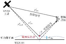
Fig. 1
Geometric model for inversion of spaceborne GNSS-R altimetry"
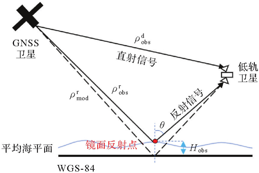

Fig. 2
iGNSS-R signal processing basic flow"
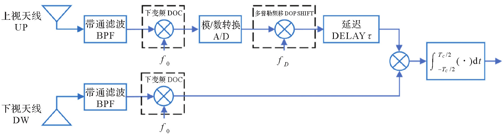
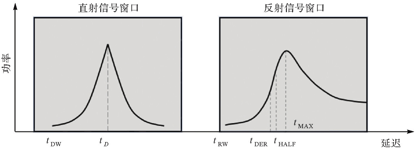
Fig. 3
Direct and reflection signal delay"
Tab. 1
COATS system and its receiver key parameters"
| 轨道高度/km | 接收机带宽/MHz | 采样率/MHz | 通道数 |
|---|---|---|---|
| 900 | 80 | 112 | 4 |
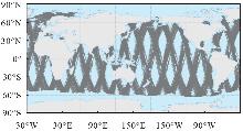
Fig. 4
Distribution of mirror specular point trajectories after quality control"

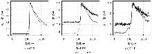
Fig. 5
Multi-mode multi-frequency normalized interference power waveforms"

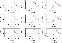
Fig. 6
High-frequency incoherent averaged waveforms with different sample sizes"

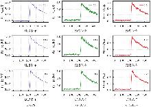
Fig. 7
Low-frequency incoherent averaged waveforms with different sample sizes"
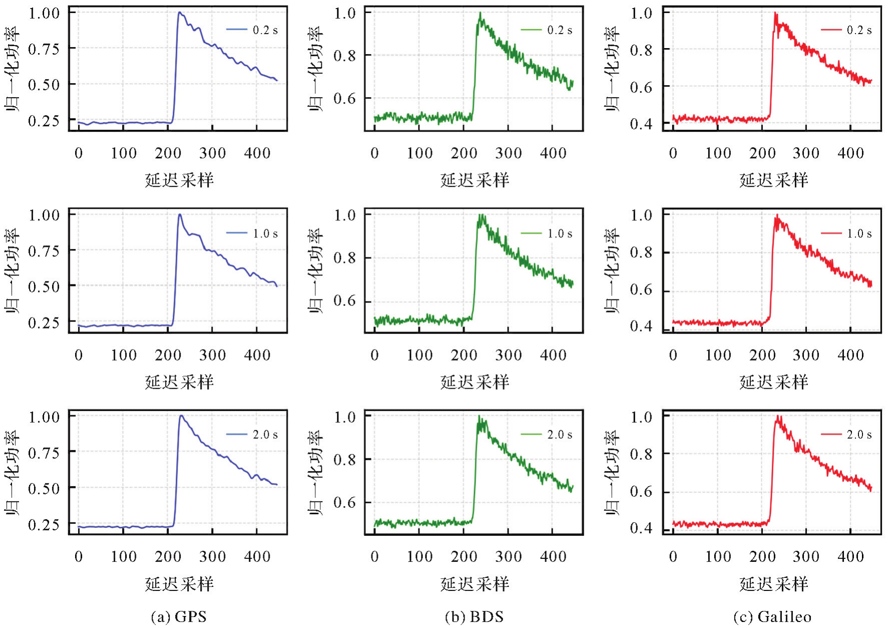
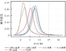
Fig. 8
SNR probability density function curves"

Tab. 2
Average SNR of multi-mode multi-frequency interference signals"
| 指标 | GPS | BDS | Galileo | |||
|---|---|---|---|---|---|---|
| L1 | L5 | B1 | B2 | E1 | E5 | |
| 平均SNR/dB | 7.83 | 7.29 | 7.98 | 2.45 | 5.13 | 2.18 |
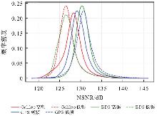
Fig. 9
NSNR probability density function curves"
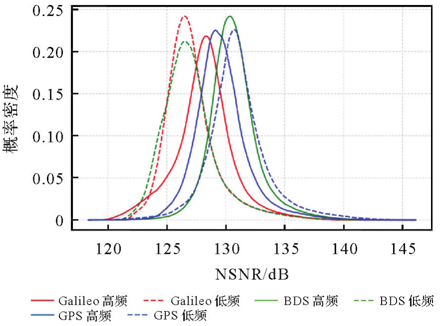
Tab. 3
Multi-mode multi-frequency signal averaged NSNR"
| 指标 | GPS | BDS | Galileo | |||
|---|---|---|---|---|---|---|
| L1 | L5 | B1 | B2 | E1 | E5 | |
| 平均SNR/dB | 129.65 | 131.04 | 130.71 | 126.99 | 128.14 | 127.09 |
Tab. 4
Number of samples in the incidence angle interval"
| 入射角区间/(°) | 高频 | 低频 | ||||
|---|---|---|---|---|---|---|
| GPS | BDS | Galileo | GPS | BDS | Galileo | |
| [0,5) | 46 645 | 117 140 | 70 423 | 51 688 | 108 523 | 61 755 |
| [5,10) | 152 584 | 332 181 | 211 687 | 176 372 | 309 532 | 187 398 |
| [10,15) | 209 434 | 541 860 | 347 660 | 296 410 | 508 678 | 310 369 |
| [15,20) | 256 598 | 734 784 | 465 352 | 348 407 | 690 941 | 418 939 |
| [20,25) | 292 772 | 867 898 | 541 226 | 374 824 | 814 360 | 494 755 |
| [25,30) | 230 314 | 749 134 | 460 987 | 301 905 | 690 430 | 427 891 |
| [30,35) | 139 750 | 458 096 | 288 224 | 186 406 | 390 899 | 278 385 |
| [35,40) | 4 | 2445 | 516 | 37 | 1011 | 512 |
| 总计 | 1 328 101 | 3 803 538 | 2 386 075 | 1 736 049 | 3 514 374 | 2 180 004 |

Fig. 10
Variation of NSNR with wind speed for the same incidence angle interval"

Tab. 5
Number of sampling points in the 2 m/s wind speed interval"
| 风速区间/(m/s) | 高频 | 低频 | ||||
|---|---|---|---|---|---|---|
| GPS | BDS | Galileo | GPS | BDS | Galileo | |
| [0,2) | 43 154 | 105 082 | 67 902 | 60 493 | 111 337 | 72 983 |
| [2,4) | 143 058 | 375 231 | 246 043 | 195 489 | 364 830 | 243 706 |
| [4,6) | 250 835 | 691 906 | 440 104 | 329 828 | 662 395 | 415 306 |
| [6,8) | 307 878 | 859 185 | 551 743 | 407 868 | 804 710 | 506 996 |
| [8,10) | 270 152 | 763 492 | 480 033 | 343 943 | 692 849 | 429 469 |
| [10,12) | 156 080 | 473 572 | 285 137 | 193 421 | 423 967 | 246 906 |
| [12,14) | 86 302 | 278 086 | 166 295 | 110 219 | 241 676 | 141 549 |
| [14,16) | 44 138 | 158 689 | 92 366 | 57 985 | 133 820 | 77 087 |
| [16,18) | 19 468 | 71 933 | 39 721 | 26 506 | 58 412 | 32 065 |
| [18,20) | 5752 | 20 125 | 12 681 | 8173 | 15 813 | 10 484 |
| [20,22) | 1066 | 4803 | 3244 | 1775 | 3418 | 2796 |
| [22,24) | 125 | 994 | 780 | 194 | 776 | 657 |
| [24,26) | 42 | 387 | 25 | 60 | 350 | 0 |
| [26,28) | 21 | 23 | 0 | 53 | 12 | 0 |
| [28,30) | 30 | 30 | 0 | 42 | 9 | 0 |
| [30,32) | 0 | 0 | 1 | 0 | 0 | 0 |
| 总计 | 1 328 101 | 3 803 538 | 2 386 075 | 1 736 049 | 3 514 374 | 2 180 004 |
Fig. 11
Variation of NSNR with angle of incidence for the same wind speed interval"

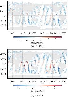
Fig. 12
Comparison of sea surface height inversion results with DTU21 model values (GPS signal)"

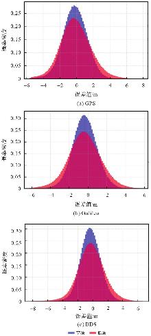
Fig. 13
Residual distribution of altitude inversion results for GPS, Galileo and BDS signals"

Tab. 6
Error metrics for altitude inversion results of GPS, Galileo and BDS signals"
| 评估指标 | MAE | STD | RMSE | 中位数 | 平均值 |
|---|---|---|---|---|---|
| L1 | 1.164 | 1.463 | 1.477 | -0.194 | -0.198 |
| L5 | 1.447 | 1.844 | 1.775 | -0.165 | -0.082 |
| E1 | 1.080 | 1.329 | 1.375 | -0.357 | -0.351 |
| E5 | 1.375 | 1.746 | 1.753 | -0.188 | -0.162 |
| B1 | 1.111 | 1.387 | 1.426 | -0.338 | -0.334 |
| B2 | 1.423 | 1.840 | 1.854 | -0.233 | -0.227 |
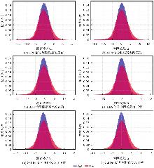
Fig. 14
Distribution of ranging residuals from GPS, BDS and Galileo signals"

Tab. 7
GPS, BDS and Galileo signal ranging residual statistics (before and after correction)"
| 评估指标 | 改正前 | 改正后 | ||
|---|---|---|---|---|
| 中位数 | 平均值 | 中位数 | 平均值 | |
| L1 | -0.377 | -0.428 | 0.273 | 0.222 |
| L5 | -0.361 | -0.337 | 0.289 | 0.313 |
| B1 | -0.630 | -0.622 | 0.020 | 0.028 |
| B2 | -0.434 | -0.431 | 0.216 | 0.219 |
| E1 | -0.669 | -0.670 | -0.019 | -0.020 |
| E5 | -0.364 | -0.361 | 0.286 | 0.289 |
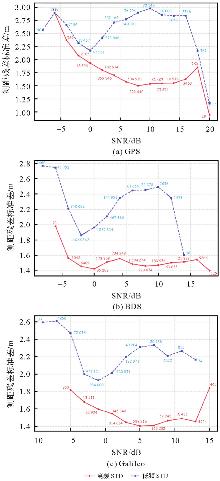
Fig. 15
Variation of standard deviation of ranging residuals with SNR for GPS, BDS and Galileo signals"

Tab. 8
Data volume and revisit statistics"
| 粗差剔除前数据量 | 粗差剔除后数据量 | 最大重访次数 | 最小重访次数 | 平均重访次数 | 网格数量 | 全球海洋覆盖率/(%) |
|---|---|---|---|---|---|---|
| 13 642 400 | 13 641 878 | 2944 | 2 | 576.26 | 23 673 | 52.19 |
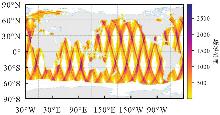
Fig. 16
Global grid average revisit rate distribution"
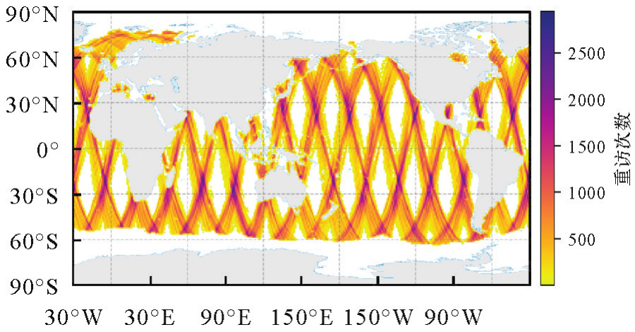

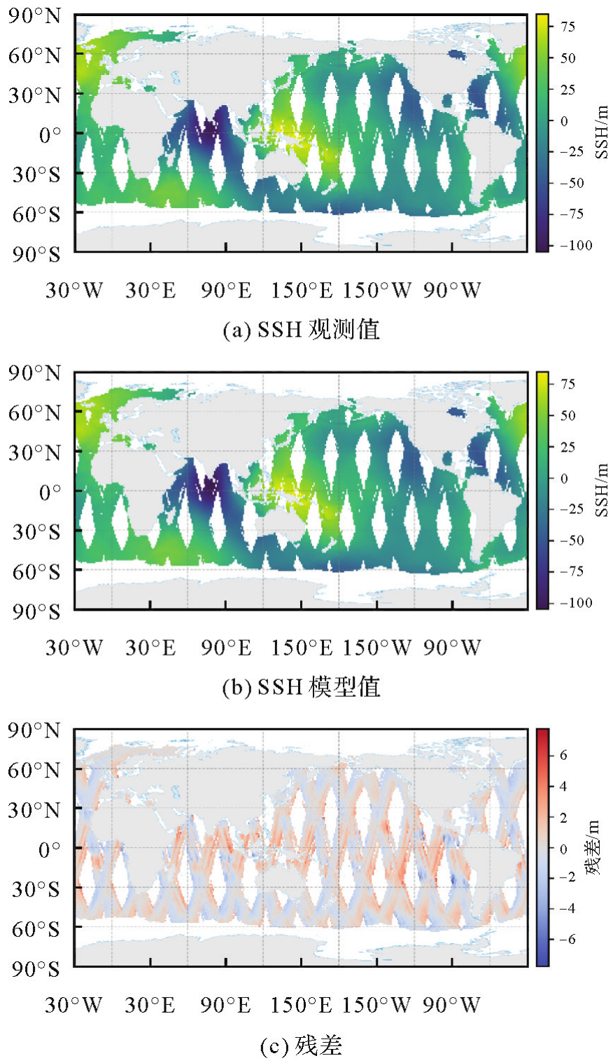
Fig. 17
Global 1° grid mean sea surface height inversion results"
Tab. 9
Accuracy of global mean sea surface height measurements"
| Bias/m | MAE/m | RMSE/m | STD/m | 相关系数/(%) |
|---|---|---|---|---|
| 0.126 | 0.881 | 1.156 | 1.149 | 99.93 |
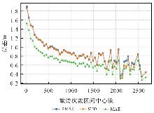
Fig. 18
Changes in measurement accuracy with number of revisits"

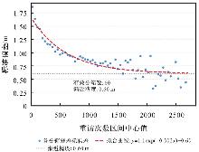
Fig. 19
Curve-fitting analysis of the correlation between high accuracy of measurement and number of revisits"

| [1] | LEVERMANN A, GRIESEL A, HOFMANN M, et al. Dynamic sea level changes following changes in the thermohaline circulation[J]. Climate Dynamics, 2005, 24(4): 347-354. |
| [2] | ARCHER M, WANG Jinbo, KLEIN P, et al. Wide-swath satellite altimetry unveils global submesoscale ocean dynamics[J]. Nature, 2025, 640(8059): 691-696. |
| [3] | HALL C D, CORDEY R A. Multistatic scatterometry[C]//Proceedings of 1988 Remote Sensing: Moving Toward the 21st Century. Edinburgh: International Geoscience and Remote Sensing Symposium, 1988: 561-562. |
| [4] | MARTIN-NEIRA M. A passive reflectometry and interferometry system (PARIS): application to ocean altimetry[J]. ESA Journal, 1993, 17: 331-355. |
| [5] | GLEASON S, HODGART S, SUN Yiping, et al. Detection and processing of bistatically reflected GPS signals from low Earth orbit for the purpose of ocean remote sensing[J]. IEEE Transactions on Geoscience and Remote Sensing, 2005, 43(6): 1229-1241. |
| [6] | UNWIN M, JALES P, TYE J, et al. Spaceborne GNSS-Reflectometry on TechDemoSat-1: early mission operations and exploitation[J]. IEEE Journal of Selected Topics in Applied Earth Observations and Remote Sensing, 2016, 9(10): 4525-4539. |
| [7] | RUF C S, ATLAS R, CHANG P S, et al. New ocean winds satellite mission to probe hurricanes and tropical convection[J]. Bulletin of the American Meteorological Society, 2016, 97(3): 385-395. |
| [8] | JING Cheng, NIU Xinliang, LU Feng, et al. GNSS-R from the Bufeng-1 twin satellites for sea surface winds under hurricane condition[C]//Proceedings of 2021 IEEE International Geoscience and Remote Sensing Symposium. Brussels: IEEE, 2021: 1299-1302. |
| [9] | SUN Yueqiang, WANG Xianyi, DU Qifei, et al. The status and progress of Fengyun-3e GNOS II mission for GNSS remote sensing[C]//Proceedings of 2019 IEEE International Geoscience and Remote Sensing Symposium. Yokohama: IEEE, 2019: 5181-5184. |
| [10] | CHENG Zixuan, JIN Taoyong, CHANG Xin, et al. Evaluation of spaceborne GNSS-R based sea surface altimetry using multiple constellation signals[J]. Frontiers in Earth Science, 2023, 10: 1079255. |
| [11] | MARTIN-NEIRA M, D'ADDIO S, BUCK C, et al. The PARIS ocean altimeter in-orbit demonstrator[J]. IEEE Transactions on Geoscience and Remote Sensing, 2011, 49(6): 2209-2237. |
| [12] | CARDELLACH E, RIUS A, MARTÍN-NEIRA M, et al. Consolidating the precision of interferometric GNSS-R ocean altimetry using airborne experimental data[J]. IEEE Transactions on Geoscience and Remote Sensing, 2014, 52(8): 4992-5004. |
| [13] | LI Weiqiang, YANG Dongkai, D'ADDIO S, et al. Partial interferometric processing of reflected GNSS signals for ocean altimetry[J]. IEEE Geoscience and Remote Sensing Letters, 2014, 11(9): 1509-1513. |
| [14] | FABRA F, CARDELLACH E, RIBÓ S, et al. Is accurate synoptic altimetry achievable by means of interferometric GNSS-R?[J]. Remote Sensing, 2019, 11(5): 505. |
| [15] | WU Xiang, GUO Bofeng, NAN Yang, et al. Characterization of full-spectrum GPS L1, Galileo E1, and BeiDou-3 B1 signals for interferometric GNSS-R ocean altimetry[J]. IEEE Transactions on Geoscience and Remote Sensing, 2025, 63: 5800511. |
| [16] |
孙中苗, 翟振和, 管斌, 等. 双星跟飞测高卫星在轨初步验证[J]. 测绘学报, 2024(2): 207-216. DOI: .
doi: 10.11947/j.AGCS.2024.20230264 |
|
SUN Zhongmiao, ZHAI Zhenhe, GUAN Bin, et al. Preliminary verification of dual-satellite tandem altimetry on board[J]. Acta Geodaetica et Cartographica Sinica, 2024(2): 207-216. DOI: .
doi: 10.11947/j.AGCS.2024.20230264 |
|
| [17] | SONG Minfeng, HE Xiufeng, WANG Xiaolei, et al. Study on the exploration of spaceborne GNSS-R raw data focusing on altimetry[J]. IEEE Journal of Selected Topics in Applied Earth Observations and Remote Sensing, 2020, 13: 6142-6154. |
| [18] | SAASTAMOINEN J. Atmospheric correction for the troposphere and stratosphere in radio ranging satellites[M]//HENRIKSEN S W, MANCINI A, CHOVITZ B H. Geophysical monograph series. Washington, D. C.: American Geophysical Union, 2013: 247-251. |
| [19] | LI Weiqiang, CARDELLACH E, FABRA F, et al. Assessment of spaceborne GNSS-R ocean altimetry performance using CYGNSS mission raw data[J]. IEEE Transactions on Geoscience and Remote Sensing, 2020, 58(1): 238-250. |
| [20] | HAJJ G A, ZUFFADA C. Theoretical description of a bistatic system for ocean altimetry using the GPS signal[J]. Radio Science, 2003, 38(5): 2002RS002787. |
| [21] | MASHBURN J, AXELRAD P, LOWE S T, et al. Global ocean altimetry with GNSS reflections from TechDemoSat-1[J]. IEEE Transactions on Geoscience and Remote Sensing, 2018, 56(7): 4088-4097. |
| [22] | NAN Yang, YE Shirong, LIU Jingnan, et al. Signal-to-noise ratio analyses of spaceborne GNSS-reflectometry from Galileo and BeiDou satellites[J]. Remote Sensing, 2022, 14(1): 35. |
| [23] | CHEW C, SHAH R, ZUFFADA C, et al. Demonstrating soil moisture remote sensing with observations from the UK TechDemoSat-1 satellite mission[J]. Geophysical Research Letters, 2016, 43(7): 3317-3324. |
| [24] | ANDERSEN O B, ROSE S K, ABULAITIJIANG A, et al. The DTU21 global mean sea surface and first evaluation[J]. Earth System Science Data, 2023, 15(9): 4065-4075. |
| [1] | Jinwei BU, Shuhui LIU, Shunshuang XU, Tongsu XIANG, Qiulan WANG, Chaoying JI, Xiaoqing ZUO. Construction of an empirical model for estimating the global wave period of spaceborne GNSS-R [J]. Acta Geodaetica et Cartographica Sinica, 2026, 55(4): 684-697. |
| [2] | Zhongmin MA, Shuangcheng ZHANG, Xin ZHOU, Qi LIU, Ning LIU, Hengli WANG. A flood monitoring method using FY-3 GNSS-R accounting for surface reflectivity uncertainty: a case study of the August 2 Guangdong rainstorm disaster [J]. Acta Geodaetica et Cartographica Sinica, 2026, 55(3): 451-464. |
| [3] | Shaoshuai YA, Xin LIU, Ruichen ZHOU, Zhen LI, Shaofeng BIAN, Jinyun GUO. High accuracy vertical gradient of gravity anomaly model determined from SWOT/KaRIn altimetry data during scientific phase [J]. Acta Geodaetica et Cartographica Sinica, 2025, 54(9): 1583-1595. |
| [4] | WANG Yuan, XU Huaping, LI Chunsheng, ZENG Guobing, LIU Aifang, GE Shiqi. Analysis of interferometric mapping accuracy for spaceborne distributed SAR dual-frequency alternative bistatic mode [J]. Acta Geodaetica et Cartographica Sinica, 2024, 53(3): 463-472. |
| [5] | LI Zhen, GUO Jinyun, SUN Zhongmiao, JIA Yongjun, HUANG Lingyong, SUN Heping. Global marine gravity anomalies recovered from multi-beam laser altimeter data of ICESat-2 [J]. Acta Geodaetica et Cartographica Sinica, 2024, 53(2): 252-262. |
| [6] | HUANG Lingyong, LI Shizhong, XIA Junming, WANG Haiyan, SUN Yueqiang, YANG Rixin, DU Qifei, HUANG Zhiyong. Accurate verification and evaluation of on-board GNSS-R interferometric altimetry under on-shore conditions [J]. Acta Geodaetica et Cartographica Sinica, 2024, 53(2): 239-251. |
| [7] | Peng YANG, Zhenxing WANG, Xiaobin TIAN, Shigui ZHENG, Yong HUANG. Analysis of orbit determination for inclined geosynchronous SAR using spaceborne GNSS data [J]. Acta Geodaetica et Cartographica Sinica, 2024, 53(12): 2305-2315. |
| [8] | Lingqiu CHEN, Hongzhou CHAI, Jingyang BAO, Min WANG, Naiquan ZHENG. Sea surface height inversion based on inverse modeling of multi-GNSS and multi-frequency SNR data [J]. Acta Geodaetica et Cartographica Sinica, 2024, 53(11): 2099-2110. |
| [9] | LI Xin, JIANG Boyang, WANG Taoyang, ZHANG Guo, CUI Hao, CHENG Qian. Geometric positioning accuracy improvement method without ground control points for global orthorectification of GF-3 [J]. Acta Geodaetica et Cartographica Sinica, 2023, 52(11): 1929-1940. |
| [10] | LI Zhiwei, XU Wenbin, HU Jun, FENG Guangcai, YANG Zefa, LI Jia, ZHANG Heng, CHEN Qi, ZHU Jianjun, WANG Qijie, ZHAO Rong, DUAN Meng. Partial geoscience parameters inversion from InSAR observation [J]. Acta Geodaetica et Cartographica Sinica, 2022, 51(7): 1458-1475. |
| [11] | SHAN Jie, TIAN Xiangxi, LI Shuang, LI Renfei. Advances of spaceborne laser altimetry technology [J]. Acta Geodaetica et Cartographica Sinica, 2022, 51(6): 964-982. |
| [12] | HUANG Motao, DENG Kailiang, WU Taiqi, OUYANG Yongzhong, CHEN Xin, LIU Min, WANG Xu. Rigorous modification model of upward continuation and its applications on the downward continuation of gravity anomaly [J]. Acta Geodaetica et Cartographica Sinica, 2022, 51(1): 41-52. |
| [13] | XIE Junfeng, LIU Ren. Sliding window Gaussian fitting algorithm for ranging error suppression of full-waveform spaceborne laser [J]. Acta Geodaetica et Cartographica Sinica, 2021, 50(9): 1240-1250. |
| [14] | WU Lixin, LI Jia, MIAO Zelang, WANG Wei, CHEN Biyan, LI Zhiwei, DAI Wujiao, XU Wenbin. Pattern and directions of spaceborne-airborne-ground collaborated intelligent monitoring on the geo-hazards developing environment and disasters in glacial basin [J]. Acta Geodaetica et Cartographica Sinica, 2021, 50(8): 1109-1121. |
| [15] | ZHANG Yongjun, ZHANG Zuxun, GONG Jianya. Generalized photogrammetry of spaceborne, airborne and terrestrial multi-source remote sensing datasets [J]. Acta Geodaetica et Cartographica Sinica, 2021, 50(1): 1-11. |
| Viewed | ||||||
|
Full text |
|
|||||
|
Abstract |
|
|||||