

Acta Geodaetica et Cartographica Sinica ›› 2026, Vol. 55 ›› Issue (4): 739-752.doi: 10.11947/j.AGCS.2026.20250523
• Cartography and Geographic Information • Previous Articles Next Articles
Xini HU1( ), Mengjun KANG1(), Liang GE2,3, Shiliang SU1, Min WENG1
Received:2025-12-15
Revised:2026-03-26
Online:2026-05-11
Published:2026-05-11
Contact:
Mengjun KANG
E-mail:xinihu@whu.edu.cn;mengjunk@whu.edu.cn
About author:HU Xini (2000—), female, PhD candidate, majors in geographic artificial intelligence and spatial information visualization. E-mail: xinihu@whu.edu.cn
Supported by:CLC Number:
Xini HU, Mengjun KANG, Liang GE, Shiliang SU, Min WENG. Intelligent design of terrain visualization for online maps[J]. Acta Geodaetica et Cartographica Sinica, 2026, 55(4): 739-752.
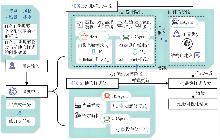
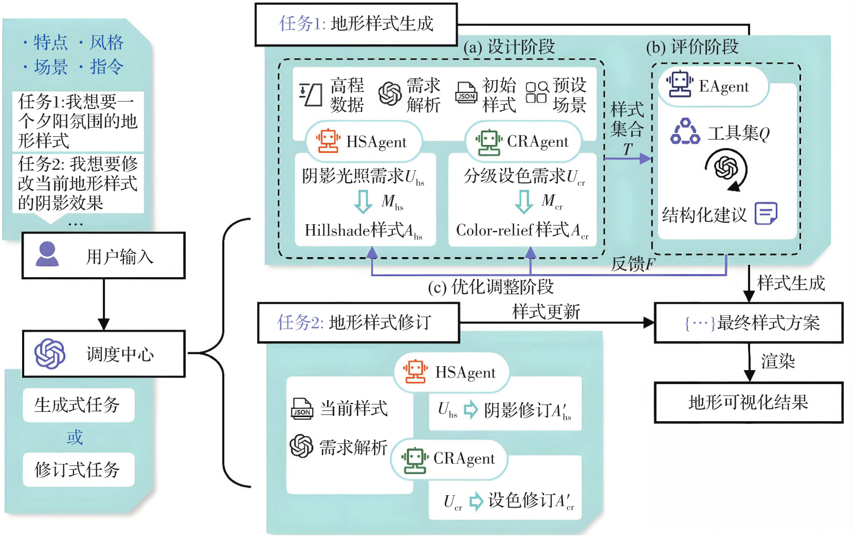
Fig. 1
Technical workflow"
Tab. 1
Examples of SceneModule in HSAgent"
| 场景 | 主要用途 | 设计特点与原则 | 光照阴影参数建议/示例 |
|---|---|---|---|
| 自然生态环境 | 用于生态格局认知、自然环境展示等 | 地形表达应以自然连续性和整体协调性为主 | 方法:igor/combined;Exaggeration:0.3~0.6;Illumination-direction:315°;Highlight-color:冷白色(#e6f2ff);Shadow-color:(蓝灰色)#2a4858;Accent-color:墨绿色(#c8e6c9) |
| 儿童趣味科普 | 用于儿童辨识地貌,提升儿童对地形的了解和兴趣 | 阴影对比度控制在中等水平;高光明亮柔和,维持画面友好度 | 方法:standard;Exaggeration:0.2~0.4;Illumination-direction:315°;Highlight-color:浅米黄(#fcfaee);Shadow-color:灰棕色(#757061);Accent-color:棕褐色(#dc852e) |
| 无人机低空经济 | 用于支撑低空飞行任务的空间认知与航线规划 | 根据无人机飞行特点突出可用空间与非可用空间的地形差异 | 方法:standard;Exaggeration:适中(0.25);Shadow-color=深灰色(#222222);Highlight-color=灰白色(#eeeeee) |
Tab. 2
Examples of SceneModule in CRAgent"
| 场景 | 设计特点与原则 | 高程配色建议/示例 |
|---|---|---|
| 自然生态环境 | 参考环境相关的连续色带[ |  |
| 儿童趣味科普 | 高程分级适中,等级含义清晰,避免细碎分级,要符合儿童的视觉习惯 |  |
| 无人机低空经济 | 空域飞行范围设定为[0,3000]m,其中近地活动层(非管制空域) |  |
| 如[0,120)m、[120,300)m采用精细分级;[300,3000](管制空域) | ||
| 可采用较粗分级,呈现可用空间与非可用空间的颜色层次 |
Tab. 3
Evaluation indicators and interpretations"
| 指标范畴 | 评价指标 | 指标内涵 |
|---|---|---|
| Hillshade | 视觉平衡性 | 评估阴影整体效果:①夸张度评估:避免极端值。②颜色对比:阴影色与高光色的对比度是否恰当,如避免阴影比高光亮度高的情况 |
| 坡度清晰度 | 检查accent-color与阴影/高光的亮度差异是否合适,避免强调色无效(与高光/阴影太接近) | |
| 光源合理性 | 光源方向、亮部/暗部的色调与亮度关系是否自然可信,如避免冷色亮部、暖色暗部的情况 | |
| Color-relief | 层级辨识度 | 层级辨识度基于色带的分段数量与高程覆盖范围进行估计。若覆盖范围较广但是分段数量极少,则分数偏低 |
| 色彩协调度 | 相邻颜色RGB距离是否适中,避免存在差异过小或过大的极端情况,距离过低(区分不明显)或过高(色彩跳跃)都会降低分数 | |
| 色彩平滑度 | 基于相邻色段在CIELab空间中的色差(ΔE)进行估计,使配色更符合人眼感知[ | |
| 冲突检测 | 配色冲突检测 | 阴影颜色与色带色彩是否出现极近或近互补的色相冲突 |
| 不透明度冲突检测 | 色带不透明度是否过高导致阴影信息被遮挡 |
Tab. 4
Comparison of DeepSeek with other models"
| 模型 | 参数规模 | 推理精度 | 成本与部署难度 |
|---|---|---|---|
| DeepSeek-V3-Chat | 总计6.71×10¹¹,激活约3.7×10¹⁰ | FP16/INT8 | 成本低,可稳定调用,部署难低 |
| GPT-4 | 未公开 | FP16 | 调用成本高,本地部署难度大 |
| Llama 3.1 | 7.0×10¹⁰(全部激活) | FP16/INT8 | 成本低,受硬件影响大,以英文语料库为主 |
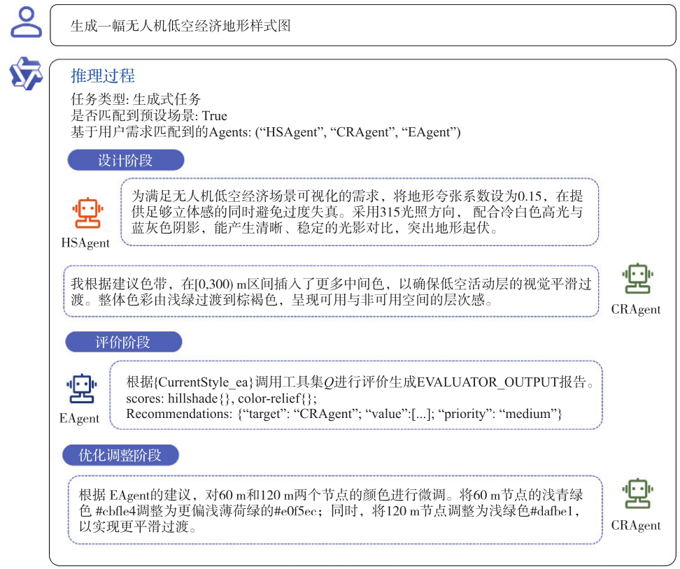
Fig. 2
MA3DVis inference in the generative task"
Tab. 5
Preset scene text prompts"
| 场景 | 用户提示词 |
|---|---|
| 无人机低空经济 | 生成一幅无人机低空经济地形样式图 |
| 儿童趣味科普 | 设计一个适合儿童趣味认知的地形样式 |
| 城市地形 | 设计一个清新淡雅的城市地形底图 |
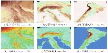
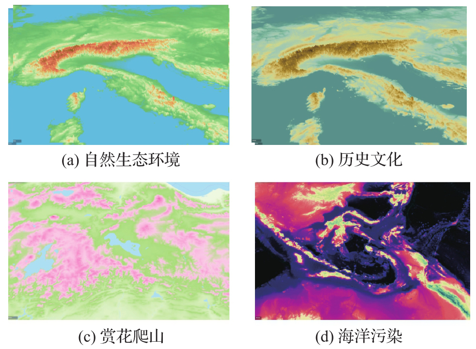
Fig. 3
Generation results of preset scene prompts under multi-scales"
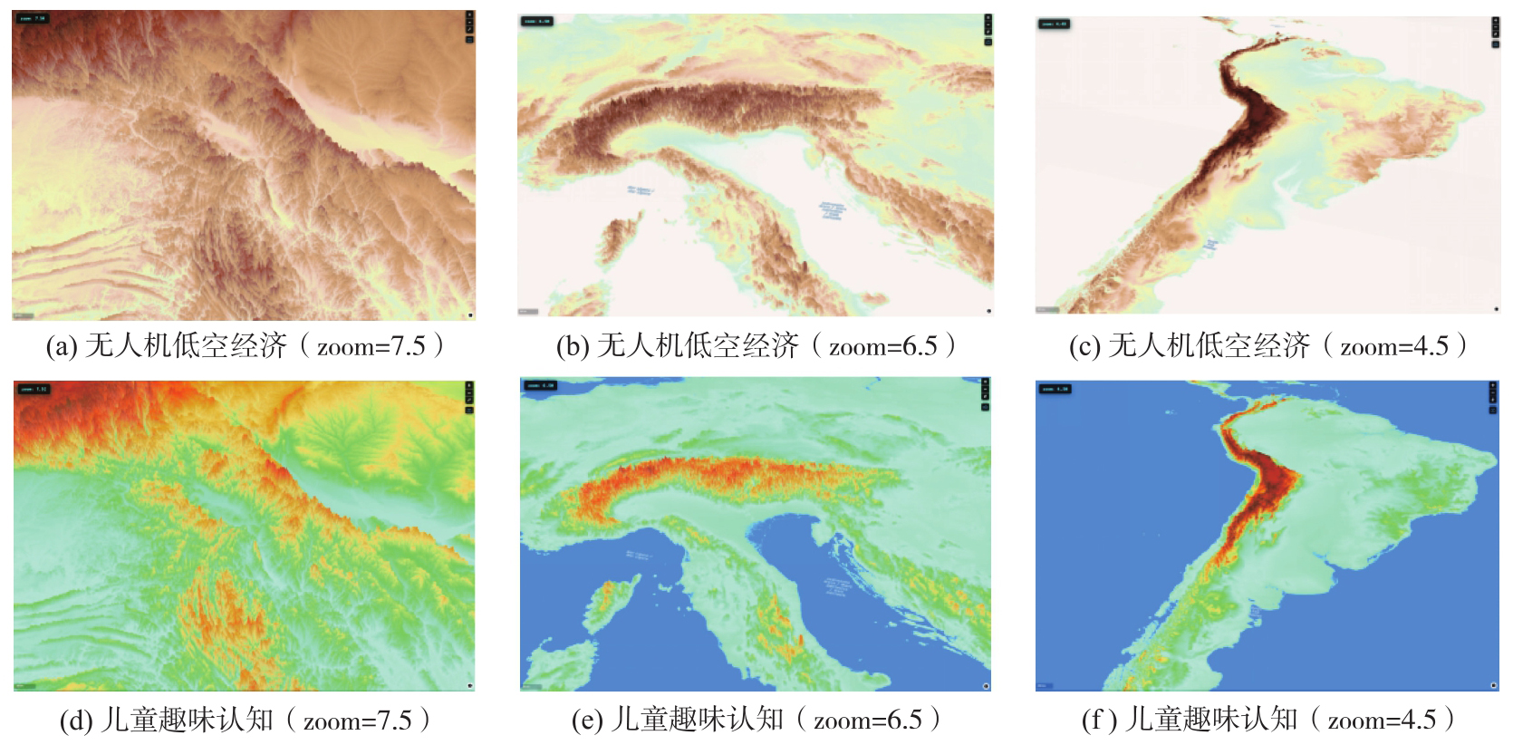

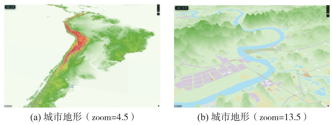
Fig. 4
Urban terrain and its overlay with other map elements"
Tab. 6
Free scene text prompts"
| 场景 | 用户提示词 |
|---|---|
| 丛林探险 | 设计一个适合丛林探险风格的地形样式 |
| 海洋展示 | 生成一个清透自然的海洋地形样式 |
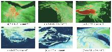
Fig. 5
Generation results of free scene prompts under multi-scales"
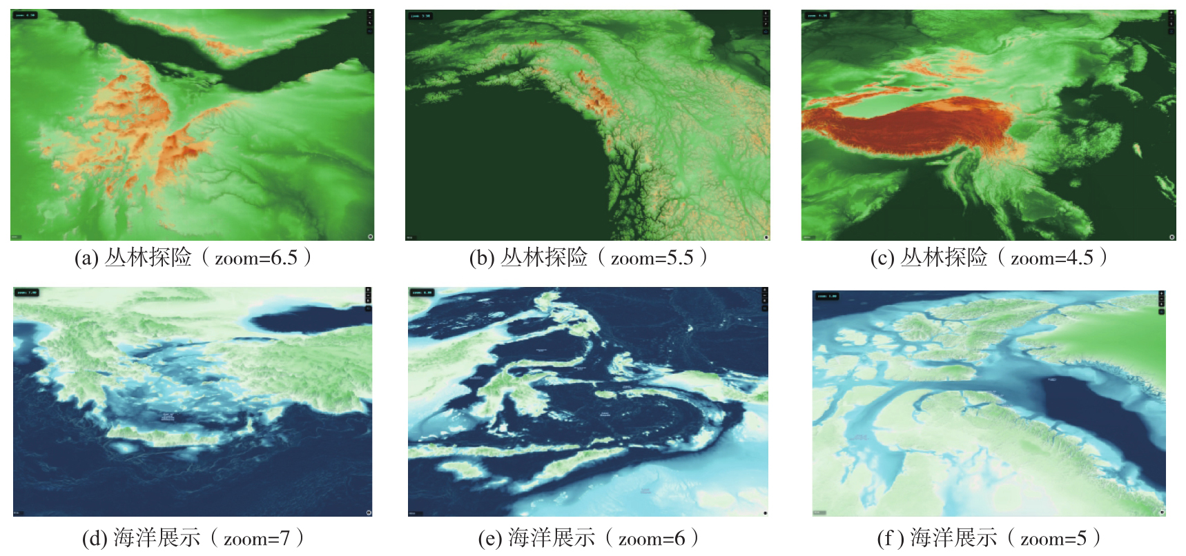
Fig. 6
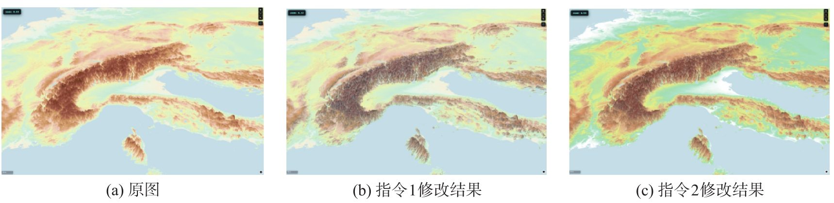
An example of MA3DVis inference in the editing task"

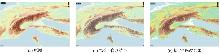
Fig. 7
Results of the editing task"
Tab. 7
Comparison of different terrain visualization methods"
| 方法 | 是否提供文本交互 | 是否支持多尺度 | 是否支持无专业背景的用户 |
|---|---|---|---|
| ArcGIS Pro | 否 | 是 | 否 |
| 本文方法 | 是 | 是 | 是 |

Fig. 8
Comparison between the preposed method and ArcGIS Pro (low-altitude UAV economic scene)"
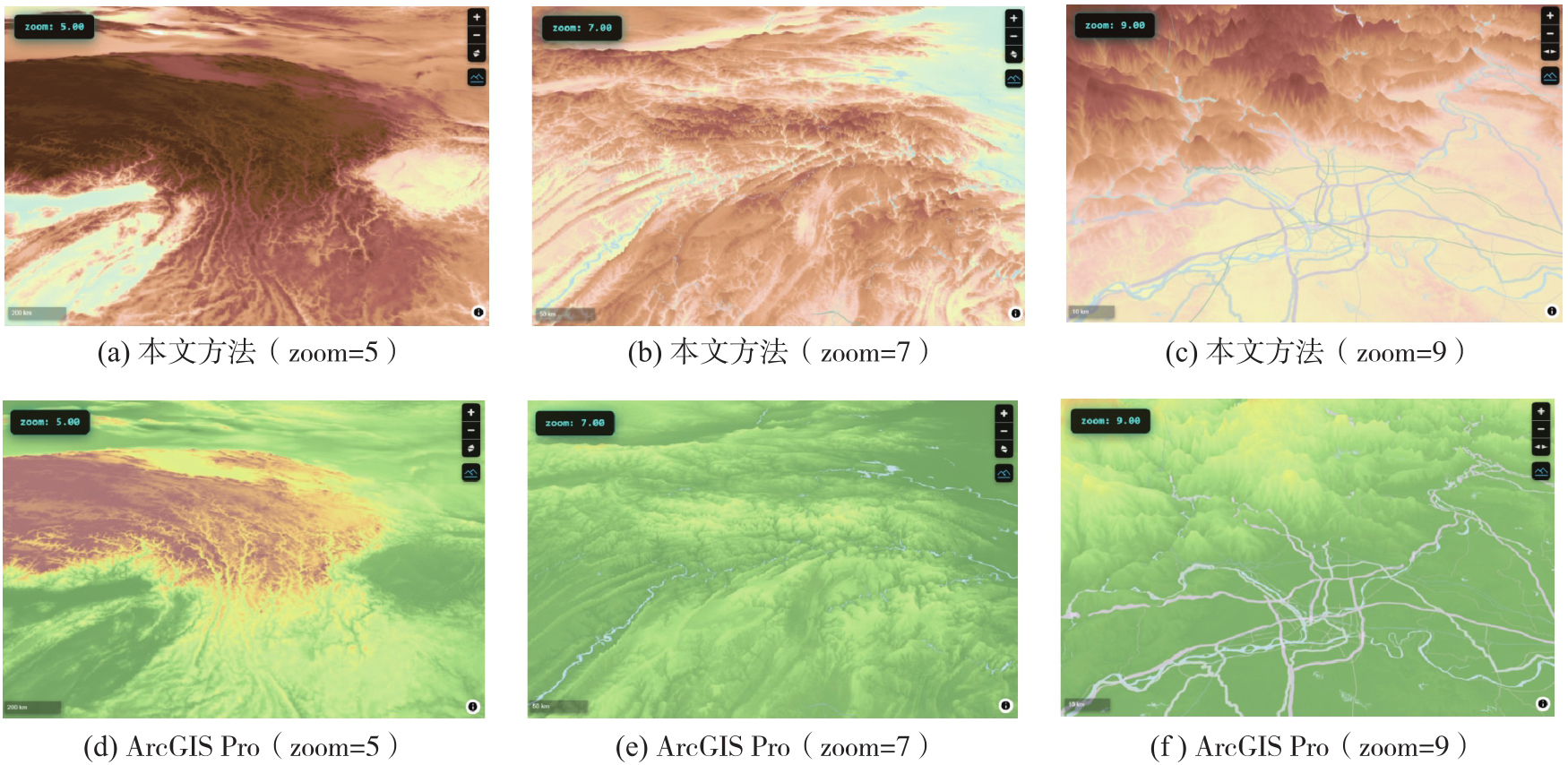
Fig. 9
Comparison between the preposed method and ArcGIS Pro (jungle adventure scene)"
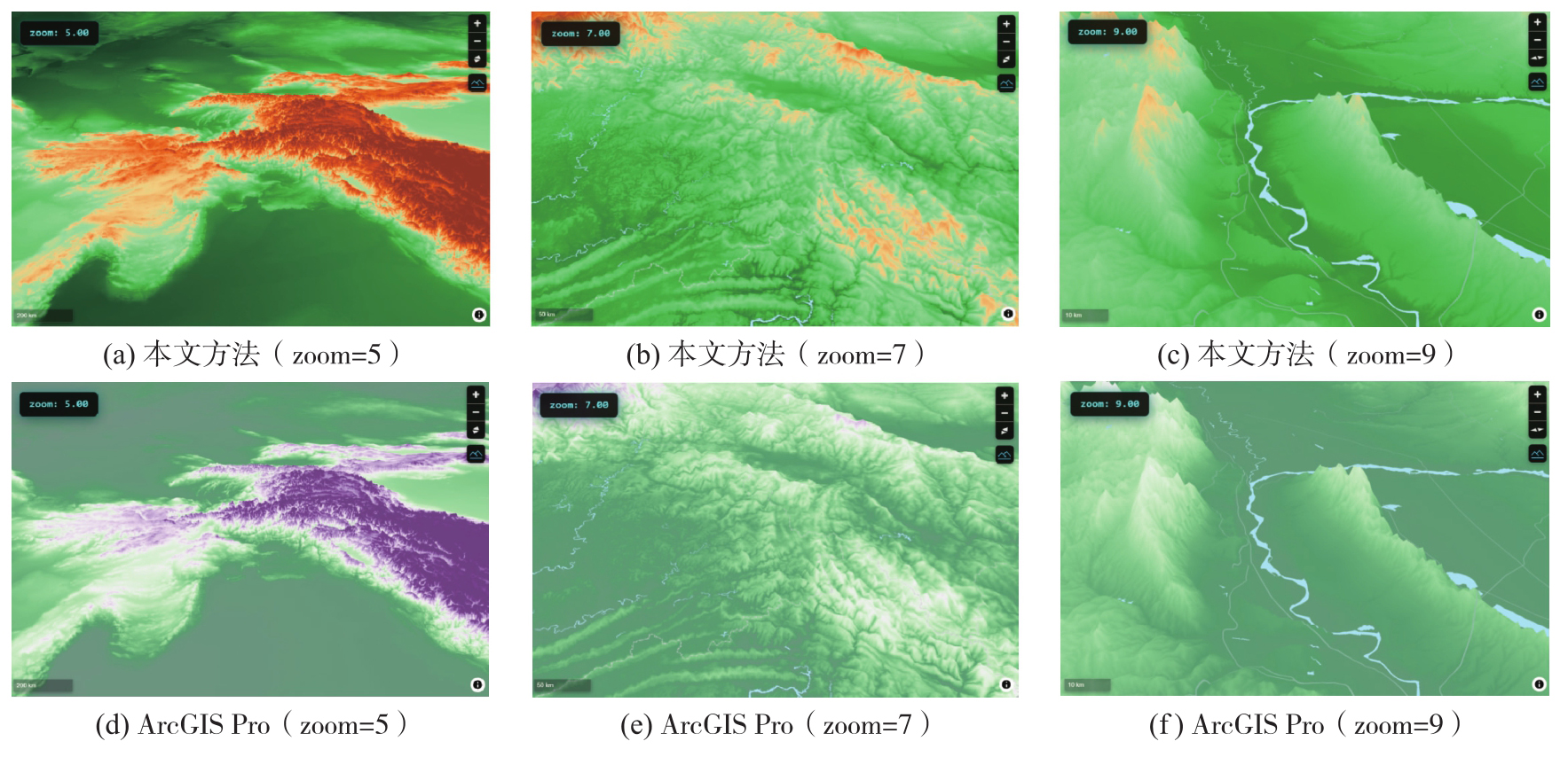
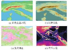
Fig. 10
Visualization results of the proposed method under different scenarios"
Tab. 8
Subjective evaluation questionnaire results"
| 题项号 | 预设场景的得分 | 自由场景的得分 | ||
|---|---|---|---|---|
| 平均值 | 标准差 | 平均值 | 标准差 | |
| Q1 | 4.40 | 0.700 | 4.56 | 0.675 |
| Q2 | 4.44 | 0.675 | 4.52 | 0.677 |
| Q3 | 4.34 | 0.745 | 4.48 | 0.677 |
| Q4 | 4.38 | 0.697 | 4.46 | 0.646 |
| Q5 | 4.34 | 0.717 | 4.54 | 0.762 |
| Q6 | 4.36 | 0.693 | 4.34 | 0.772 |
| Q7 | 4.36 | 0.875 | 4.56 | 0.644 |
| Q8 | 4.38 | 0.667 | 4.46 | 0.734 |
| Q9 | 4.42 | 0.758 | 4.52 | 0.762 |
| [1] | HORN B K. Hill shading and the reflectance map[J]. Proceedings of the IEEE, 1981, 69(1): 14-47. |
| [2] | KENNELLY P J. Terrain maps displaying hill-shading with curvature[J]. Geomorphology, 2008, 102(3/4): 567-577. |
| [3] | 江文萍, 毋河海, 杜清运, 等. 大型彩色地貌晕渲图的自动生成技术研究[J]. 武汉大学学报(信息科学版), 2004, 29(6): 496-499. |
| JIANG Wenping, WU Hehai, DU Qingyun, et al. Automatic generation technology of large-scale colored hill-shading[J]. Geomatics and Information Science of Wuhan University, 2004, 29(6): 496-499. | |
| [4] | 李凤霞, 王欣欣, 黄天羽. 一种动态地形实时可视化系统框架[J]. 系统仿真学报, 2009, 21(S1): 151-154. |
| LI Fengxia, WANG Xinxin, HUANG Tianyu. A real-time visualization system framework of dynamic terrain[J]. Journal of System Simulation, 2009, 21(S1): 151-154. | |
| [5] | RUZINOOR C M, SHARIFF A R M, PRADHAN B, et al. A review on 3D terrain visualization of GIS data: techniques and software[J]. Geo-spatial Information Science, 2012, 15(2): 105-115. |
| [6] | JEROME O, BASSEY C, OKEME C, et al. MeshNav3D: software for visualizing and benchmarking uneven terrain planning algorithms[J]. Journal of Open Research Software, 2025, 13: 19. |
| [7] | 郭韵玲, 龚玉叶, 蒋巍, 等. 基于三维地形优化的水源保护区划定研究[J]. 现代农业研究, 2024, 30(12): 112-115. |
| GUO Yunling, GONG Yuye, JIANG Wei, et al. Study on the delineation of water source protection area based on 3D terrain optimization[J]. Modern Agriculture Research, 2024, 30(12): 112-115. | |
| [8] | 顾绍鹏. 基于Vega Prime/Creator导弹飞行轨迹模拟跟踪技术研究[D]. 哈尔滨: 哈尔滨工程大学, 2016. |
| GU Shaopeng. Research on missile flight trajectory simulation and tracking technology based on vega prime/creator[D]. Harbin: Harbin Engineering University, 2016. | |
| [9] | OLYAZADEH R, SUDMEIER-RIEUX K, JABOYEDOFF M, et al. An offline-online Web-GIS Android application for fast data acquisition of landslide hazard and risk[J]. Natural Hazards and Earth System Sciences, 2017, 17(4): 549-561. |
| [10] | YU Miao, HUANG Yu, XU Qiang, et al. Application of virtual earth in 3D terrain modeling to visual analysis of large-scale geological disasters in mountainous areas[J]. Environmental Earth Sciences, 2016, 75(7): 563. |
| [11] | DÜBEL S, RÖHLIG M, TOMINSKI C, et al. Visualizing 3D terrain, geo-spatial data, and uncertainty[J]. Informatics, 2017, 4(1): 6. |
| [12] | 杨乃, 孔凡秋, 杨鸿海, 等. 基于空间认知的三维地图光影模型[J]. 测绘学报, 2012, 41(2): 302-308. |
| YANG Nai, KONG Fanqiu, YANG Honghai, et al. Model of light and shadow in 3D map based on spatial cognition[J]. Acta Geodaetica et Cartographica Sinica, 2012, 41(2): 302-308. | |
| [13] | ROSE T J, BAKAOUKAS A G. Algorithms and approaches for procedural terrain generation-a brief review of current techniques[C]//Proceedings of 2016 International Conference on Games and Virtual Worlds for Serious Applications. Barcelona: IEEE, 2016: 1-2. |
| [14] | FERRARIS J, GATZIDIS C. A rule-based approach to 3D terrain generation via texture splatting[C]//Proceedings of 2009 International Conference on Advances in Computer Entertainment Technology. Athens: ACM Press, 2009: 407-408. |
| [15] | 陈望婷, 朱庆. 地形三维可视化中的彩色地貌晕渲图多模式色彩设计[J]. 测绘信息与工程, 2006, 31(6): 47-49. |
| CHEN Wangting, ZHU Qing. Design of multi-model colour in colored hill-shading for terrain 3D visualization[J]. Journal of Geomatics, 2006, 31(6): 47-49. | |
| [16] | CHEN W, ZHU Q. Design of multi-model colour in colored hill-shading for terrain 3D visualization[J]. Journal of Environmental Planning and Management, 2007, 50(1): 49. |
| [17] | 林松, 程维明, 乔玉良. 基于Global Mapper的地貌晕渲制图:以西安幅(I-49)为例[J]. 地球信息科学学报, 2009, 11(6): 802-808. |
| LIN Song, CHENG Weiming, QIAO Yuliang. Methodology of automatic relief shading map making based on global mapper: taking Xi'an Region (I-49) as an example[J]. Journal of Geo-information Science, 2009, 11(6): 802-808. | |
| [18] | BRATKOVA M, SHIRLEY P, THOMPSON W B. Artistic rendering of mountainous terrain[J]. ACM Transactions on Graphics, 2009, 28(4): 1-17. |
| [19] | RUSINKIEWICZ S, BURNS M, DECARLO D. Exaggerated shading for depicting shape and detail[J]. ACM Transactions on Graphics, 2006, 25(3): 1199-1205. |
| [20] | DÜBEL S, SCHUMANN H. Visualization of features in 3D terrain[J]. ISPRS International Journal of Geo-Information, 2017, 6(11): 357. |
| [21] | KENNELLY P J, STEWART A J. General sky models for illuminating terrains[J]. International Journal of Geographical Information Science, 2014, 28(2): 383-406. |
| [22] | 俞键, 杨世保, 赵宝奇, 等. 基于改进Blinn-Phong光照模型的机载SVS地形着色方法[J]. 电光与控制, 2024, 31(2): 92-97. |
| YU Jian, YANG Shibao, ZHAO Baoqi, et al. A terrain shading method of airborne SVS based on improved Blinn-Phong illumination model[J]. Electronics Optics & Control, 2024, 31(2): 92-97. | |
| [23] | GRIGNARD A, FANTINO G, LAUER JW, et al. Agent-based visualization: a simulation tool for the analysis of river morphosedimentary adjustments[C]//Procedings of 2015 International Workshop on Multi-Agent Systems and Agent-Based Simulation. Cham: Springer, 2016: 109-120. |
| [24] | LI Xiong, PU Wei, RONG Jiang, et al. Terrain visualization information integration in agent-based military industrial logistics simulation[J]. Journal of Industrial Information Integration, 2022, 25: 100260. |
| [25] | 杨必胜, 陈一平, 邹勤. 从大模型看测绘时空信息智能处理的机遇和挑战[J]. 武汉大学学报(信息科学版), 2023, 48(11): 1756-1768. |
| YANG Bisheng, CHEN Yiping, ZOU Qin. Opportunities and challenges of spatiotemporal information intelligent processing of surveying and mapping in the era of large models[J]. Geomatics and Information Science of Wuhan University, 2023, 48(11): 1756-1768. | |
| [26] | 张帅豪, 潘志刚. 遥感大模型:综述与未来设想[J]. 遥感技术与应用, 2025, 40(1): 1-13. |
| ZHANG Shuaihao, PAN Zhigang. Remote sensing large models: review and future prospects[J]. Remote Sensing Technology and Application, 2025, 40(1): 1-13. | |
| [27] |
吴华意, 沈张骁, 侯树洋, 等. 大语言模型驱动的GIS分析:方法、应用与展望[J]. 测绘学报, 2025, 54(4): 621-635. DOI: .
doi: 10.11947/j.AGCS.2025.20240468 |
|
WU Huayi, SHEN Zhangxiao, HOU Shuyang, et al. Large language model-driven GIS analysis: methods, applications, and prospects[J]. Acta Geodaetica et Cartographica Sinica, 2025, 54(4): 621-635. DOI: .
doi: 10.11947/j.AGCS.2025.20240468 |
|
| [28] |
李志林, 徐柱, 慎利, 等. 自主式情境化地图表达:大模型时代的智能化地图制图理论探讨[J]. 测绘学报, 2024, 53(11): 2043-2052. DOI: .
doi: 10.11947/j.AGCS.2024.20240222 |
|
LI Zhilin, XU Zhu, SHEN Li, et al. Autonomous situatedness map representation: a theoretical discussion on intelligent cartography in the era of large models[J]. Acta Geodaetica et Cartographica Sinica, 2024, 53(11): 2043-2052. DOI: .
doi: 10.11947/j.AGCS.2024.20240222 |
|
| [29] | KANG Yuhao, GAO Song, ROTH R E. Artificial intelligence studies in cartography: a review and synthesis of methods, applications, and ethics[J]. Cartography and Geographic Information Science, 2024, 51(4): 599-630. |
| [30] | CHENZHEN S, TIAN L, ZHIWEI W U, et al. Generative artificial intelligence and its applications in cartography and GIS: an exploratory review[J]. Journal of Geodesy and Geoinformation Science, 2025, 8(2): 74-89. |
| [31] | GUO Taicheng, CHEN Xiuying, WANG Yaqi, et al. Large language model based multi-agents: a survey of progress and challenges[EB/OL]. [2025-12-01]. https://arxiv.org/abs/2402.01680. |
| [32] | CHEN Shuaihang, LIU Yuanxing, HAN Wei, et al. A survey on LLM-based multi-agent system: recent advances and new frontiers in application[EB/OL]. [2025-12-01]. https://arxiv.org/abs/2412.17481. |
| [33] | ZHANG Yifan, HE Zhengting, LI Jingxuan, et al. MapGPT: an autonomous framework for mapping by integrating large language model and cartographic tools[J]. Cartography and Geographic Information Science, 2024, 51(6): 717-743. |
| [34] | ZHANG Yifan, WEI Cheng, WU Shangyou, et al. GeoGPT: understanding and processing geospatial tasks through an autonomous GPT[EB/OL]. [2025-12-01]. https://arxiv.org/abs/2307.07930. |
| [35] | 王孟琪, 李伯钊, 王振立, 等. 一种集成知识图谱和大语言模型的智能地图制图框架[J]. 武汉大学学报(信息科学版). [2025-12-01]. https://doi.org/10.13203/j.whugis20240266. |
| WANG Mengqi, LI Bozhao, WANG Zhenli, et al. An automatic cartography framework integrating knowledge graph and large language model[J]. Geomatics and Information Science of Wuhan University. [2025-12-01]. https://doi.org/10.13203/j.whugis20240266. | |
| [36] | WANG Chenglong, KANG Yuhao, GONG Zhaoya, et al. CartoAgent: a multimodal large language model-powered multi-agent cartographic framework for map style transfer and evaluation[J]. International Journal of Geographical Information Science, 2025, 39(9): 1904-1937. |
| [37] | LI Xinyi, WANG Sai, ZENG Siqi, et al. A survey on LLM-based multi-agent systems: workflow, infrastructure, and challenges[J]. Vicinagearth, 2024, 1: 9. |
| [38] | WOO M, NEIDER J, DAVIS T, et al. OpenGL programming guide: the official guide to learning OpenGL, version 1.2[M]. Boston: Addison-Wesley Longman Publishing Co., Inc., 1999. |
| [39] | AKENINE-MOLLER T, HAINES E, HOFFMAN N. Real-time rendering[M]. Natick: CRC Press, 2019. |
| [40] | BREWER C. Designing better maps: a guide for GIS users[M]. 2nd ed. Redlands: ESRI Press, 2016. |
| [41] | MAPLIBRE C. Layers—MapLibre style specification[EB/OL]. [2025-12-01]. https://maplibre.org/maplibre-style-spec/layers/#paint-hillshade-hillshade-method. |
| [42] | PATTERSON T, JENNY B. The development and rationale of cross-blended hypsometric tints[J]. Cartographic Perspectives, 2011(69): 31-46. |
| [43] | WEI J, WANG Xuezhi, SCHUURMANS D, et al. Chain-of-thought prompting elicits reasoning in large language models[C]//Proceedings of 2022 Advances in Neural Information Processing Systems. New Orleans: Neural Information Processing Systems Foundation, Inc., 2022: 24824-24837. |
| [44] | BUCKINGHAM B, HARROWER M. The role of color saturation in maps for children[J]. Cartographic Perspectives, 2007(58): 28-47. |
| [45] | FILIPPAKOPOULOU V, MICHAELIDOU E, NAKOS B. A study of children's perception of cartographic landform representation[C]//Proceedings of 1998 Maps for Special Users. Wroclaw: ICA, 1998: 93-104. |
| [46] | GDAL C. GDALDEM—GDAL documentation[EB/OL]. [2026-02-24]. https://gdal.org/en/stable/programs/gdaldem.html. |
| [47] | HARROWER M, BREWER C A. ColorBrewer.org: an online tool for selecting colour schemes for maps[J]. The Cartographic Journal, 2003, 40(1): 27-37. |
| [48] | SAMSEL F, TURTON T L, WOLFRAM P, et al. Intuitive colormaps for environmental visualization[C]//Proceedings of 2017 Workshop on Visualisation in Environmental Sciences. Goslar: Eurographics Association, 2017: 55-59. |
| [49] | CRAMERI F, SHEPHARD G E, HERON P J. The misuse of colour in science communication[J]. Nature Communications, 2020, 11: 5444. |
| [1] | Zhiwei WEI, Nai YANG, Yijie WANG, Hua LIAO, Mengjie ZHOU, Wenjia XU. MapColor-Agent:a large language model-integrated multi-agent framework for administrative map color design [J]. Acta Geodaetica et Cartographica Sinica, 2026, 55(2): 359-370. |
| [2] | Xin HU, Xuexi YANG, Yifan JIANG, Xianbin WANG, Chen DING, Guran XIE, Min DENG. Hierarchical multi-agent collaboration for geographic event extraction and spatio-temporal parsing [J]. Acta Geodaetica et Cartographica Sinica, 2025, 54(11): 2052-2067. |
| [3] | . A spatio-temporal simulation and planning model for farmland conversion based on multi-agent systems [J]. Acta Geodaetica et Cartographica Sinica, 2011, 40(3): 366-372. |
| Viewed | ||||||
|
Full text |
|
|||||
|
Abstract |
|
|||||