

Acta Geodaetica et Cartographica Sinica ›› 2025, Vol. 54 ›› Issue (7): 1215-1229.doi: 10.11947/j.AGCS.2025.20240440
• Photogrammetry and Remote Sensing • Previous Articles Next Articles
Tianjun WU1( ), Manjia LI2,3, Jiancheng LUO2,3(), Ziqi LI2,3, Xiaodong HU4, Lijing GAO2, Zhanfeng SHEN2,3
Received:2024-09-14
Revised:2025-06-20
Online:2025-08-18
Published:2025-08-18
Contact:
Jiancheng LUO
E-mail:tjwu@chd.edu.cn;luojc@aircas.ac.cn
About author:WU Tianjun (1986—), male, PhD, professor, majors in intelligent remote sensing and geographic spatio-temporal intelligence. E-mail: tjwu@chd.edu.cn
Supported by:CLC Number:
Tianjun WU, Manjia LI, Jiancheng LUO, Ziqi LI, Xiaodong HU, Lijing GAO, Zhanfeng SHEN. Farmland-parcel-based crop remote sensing classification method in complex mountainous areas via coupling spatial distribution patterns[J]. Acta Geodaetica et Cartographica Sinica, 2025, 54(7): 1215-1229.
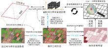
Fig. 1
Land-parcel-based crop remote sensing classification process of Tu-Pu collaborative analysis[40]"

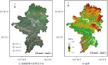
Fig. 2
Remote sensing image, distribution map of ground samples, and altitudes in the study area"

Tab. 1
Phenological information of major annual crops in Tongnan district, Chongqing city"
| 作物类型 | 播种期 | 苗期 | 分蘖期 | 拔节期 | 抽穗期 | 灌浆成熟期 |
|---|---|---|---|---|---|---|
| 水稻 | 2月下旬至 | 3月中旬至 | 4月下旬至 | 5月下旬至 | 6月下旬至 | 7月中旬至 |
| 3月上旬 | 4月中旬 | 5月中旬 | 6月中旬 | 7月上旬 | 8月中旬 | |
| 玉米 | 2月下旬至 | 3月下旬至 | — | 5月中旬至 | 6月中旬至 | 7月上旬至 |
| 3月中旬 | 5月上旬 | 6月上旬 | 6月下旬 | 8月中旬 |
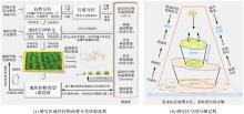
Fig. 3
Experimental flowchart and spatial decomposition process of land-parcel-based crop remote sensing classification in the study area"


Fig. 4
Geographical zoning map and cultivated land-parcel extraction results of the study area"

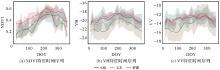
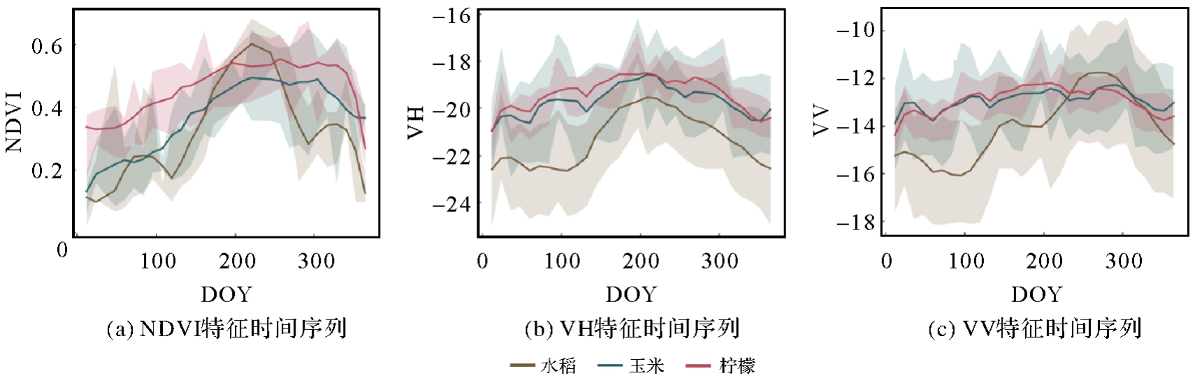
Fig. 5
Time-series feature curve of major crops in the study area"
Tab. 2
Accuracy evaluation of land-parcel-based crop remote sensing classification"
| 作物类别 | OA | 正确率 | 召回率 | F1值 | 信息熵 |
|---|---|---|---|---|---|
| 水稻 | — | 0.926 | 0.907 | 0.917 | -0.634 |
| 玉米 | — | 0.724 | 0.712 | 0.718 | -0.976 |
| 柠檬 | — | 0.891 | 0.919 | 0.905 | -0.560 |
| 其他 | — | 0.795 | 0.816 | 0.805 | -0.895 |
| 总体 | 0.883 | 0.890 | 0.885 | 0.887 | -0.757 |
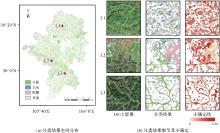
Fig. 6
The results of land-parcel-based crop remote sensing classification and its spatial distribution of uncertainty"


Fig. 7
Comparison of classification results before and after constraint of vertical spatial distribution pattern (where positions L1, L2, and L3 are marked in Fig. 6)"

Tab. 3
Comparison of classification accuracy at different scales"
| 特征类型 | OA | 正确率 | 召回率 | F1值 | 信息熵 |
|---|---|---|---|---|---|
| 像元级 | 0.808 | 0.816 | 0.812 | 0.814 | -0.885 |
| 像元级-地块约束 | 0.851 | 0.834 | 0.838 | 0.836 | -0.733 |
| 地块级 | 0.883 | 0.890 | 0.885 | 0.887 | -0.757 |
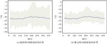
Fig. 8
Time-series feature curves of maize using land-parcel-based and pixel-based statistics"

Tab. 4
Comparison of uncertainty before and after sample supplement"
| 地块ID | 其他隶属度 | 水稻隶属度 | 不确定性 | 其他隶属度 | 水稻隶属度 | 不确定性 |
|---|---|---|---|---|---|---|
| 目标地块 | 0.53 | 0.47 | 0.997 | 0.39 | 0.61 | 0.967 |
| 邻域单元1 | 0.25 | 0.75 | 0.808 | 0.19 | 0.81 | 0.701 |
| 邻域单元2 | 0.61 | 0.39 | 0.964 | 0.58 | 0.42 | 0.981 |
| 邻域单元3 | 0.34 | 0.66 | 0.925 | 0.38 | 0.62 | 0.958 |
| 邻域单元4 | 0.55 | 0.45 | 0.992 | 0.24 | 0.76 | 0.793 |
| [1] | 赵春江. 农业遥感研究与应用进展[J]. 农业机械学报, 2014, 45(12): 277-293. |
| ZHAO Chunjiang. Advances of research and application in remote sensing for agriculture[J]. Transactions of the Chinese Society for Agricultural Machinery, 2014, 45(12): 277-293. | |
| [2] | 史舟, 梁宗正, 杨媛媛, 等. 农业遥感研究现状与展望[J]. 农业机械学报, 2015, 46(2): 247-260. |
| SHI Zhou, LIANG Zongzheng, YANG Yuanyuan, et al. Status and prospect of agricultural remote sensing[J]. Transactions of the Chinese Society for Agricultural Machinery, 2015, 46(2): 247-260. | |
| [3] | 陈仲新, 任建强, 唐华俊, 等. 农业遥感研究应用进展与展望[J]. 遥感学报, 2016, 20(5): 748-767. |
| CHEN Zhongxin, REN Jianqiang, TANG Huajun, et al. Progress and perspectives on agricultural remote sensing research and applications in China[J]. Journal of Remote Sensing, 2016, 20(5): 748-767. | |
| [4] | 唐华俊. 农业遥感研究进展与展望[J]. 农学学报, 2018, 8(1): 167-171. |
| TANG Huajun. Progress and prospect of agricultural remote sensing research[J]. Journal of Agriculture, 2018, 8(1): 167-171. | |
| [5] | 董金玮, 吴文斌, 黄健熙, 等. 农业土地利用遥感信息提取的研究进展与展望[J]. 地球信息科学学报, 2020, 22(4): 772-783. |
| DONG Jinwei, WU Wenbin, HUANG Jianxi, et al. State of the art and perspective of agricultural land use remote sensing information extraction[J]. Journal of Geo-information Science, 2020, 22(4): 772-783. | |
| [6] | 秦其明, 范闻捷, 任华忠, 等. 农田定量遥感理论、方法与应用[M]. 北京: 科学出版社, 2018. |
| QIN Qiming, FAN Wenjie, REN Huazhong, et al. Theory, method and applications of agricultural quantitative remote sensing of farmland[M]. Beijing: Science Press, 2018. | |
| [7] | 吴文斌, 胡琼, 陆苗, 等. 农业土地系统遥感制图[M]. 北京: 科学出版社, 2020. |
| WU Wenbin, HU Qiong, LU Miao, et al. Remote sensing mapping of agricultural land system[M]. Beijing: Science Press, 2020. | |
| [8] | 李爱农, 边金虎, 张正健, 等. 山地遥感主要研究进展、发展机遇与挑战[J]. 遥感学报, 2016, 20(5): 1199-1215. |
| LI Ainong, BIAN Jinhu, ZHANG Zhengjian, et al. Progresses, opportunities, and challenges of mountain remote sensing research[J]. Journal of Remote Sensing, 2016, 20(5): 1199-1215. | |
| [9] | 杨颖频, 吴志峰, 骆剑承, 等. 时空协同的地块尺度作物分布遥感提取[J]. 农业工程学报, 2021, 37(7): 166-174. |
| YANG Yingpin, WU Zhifeng, LUO Jiancheng, et al. Parcel-based crop distribution extraction using the spatiotemporal collaboration of remote sensing data[J]. Transactions of the Chinese Society of Agricultural Engineering, 2021, 37(7): 166-174. | |
| [10] | 吴田军, 骆剑承, 赵馨, 等. 精准地理应用驱动的高分遥感协同计算研究[J]. 武汉大学学报(信息科学版), 2022, 47(8): 1220-1235. |
| WU Tianjun, LUO Jiancheng, ZHAO Xin, et al. Collaborative computing of high-resolution remote sensing driven by fine-accurate geographic applications[J]. Geomatics and Information Science of Wuhan University, 2022, 47(8): 1220-1235. | |
| [11] | 张冬韵, 吴田军, 李曼嘉, 等. 地块尺度农作物遥感分类及其不确定性分析[J]. 自然资源遥感, 2024, 36(4): 124-134. |
| ZHANG Dongyun, WU Tianjun, LI Manjia, et al. Remote sensing-based classification of crops on a farmland parcel scale and uncertainty analysis[J]. Remote Sensing for Natural Resources, 2024, 36(4): 124-134. | |
| [12] | 张冬韵, 吴田军, 骆剑承, 等. 时空协同的农业种植结构遥感精细制图[J]. 遥感学报, 2024, 28(8): 2014-2029. |
| ZHANG Dongyun, WU Tianjun, LUO Jiancheng, et al. Precise crop planting structure mapping method based on spatial-temporal collaboration of remote sensing[J]. National Remote Sensing Bulletin, 2024, 28(8): 2014-2029. | |
| [13] | HONG R, PARK J, JANG S, et al. Development of a parcel-level land boundary extraction algorithm for aerial imagery of regularly arranged agricultural areas[J]. Remote Sensing, 2021, 13(6): 1167. |
| [14] |
刘巍, 吴志峰, 骆剑承, 等. 深度学习支持下的丘陵山区耕地高分辨率遥感信息分区分层提取方法[J]. 测绘学报, 2021, 50(1): 105-116. DOI: .
doi: 10.11947/j.AGCS.2021.20190448 |
|
LIU Wei, WU Zhifeng, LUO Jiancheng, et al. A divided and stratified extraction method of high-resolution remote sensing information for cropland in hilly and mountainous areas based on deep learning[J]. Acta Geodaetica et Cartographica Sinica, 2021, 50(1): 105-116. DOI: .
doi: 10.11947/j.AGCS.2021.20190448 |
|
| [15] | PERSELLO C, TOLPEKIN V A, BERGADO J R, et al. Delineation of agricultural fields in small holder farms from satellite images using fully convolutional networks and combinatorial grouping[J]. Remote Sensing of Environment, 2019, 231: 111253. |
| [16] | WALDNER F, DIAKOGIANNIS F I. Deep learning on edge: extracting field boundaries from satellite images with a convolutional neural network[J]. Remote Sensing of Environment, 2020, 245: 111741. |
| [17] | WALDNER F, DIAKOGIANNIS F I, BATCHELOR K, et al. Detect, consolidate, delineate: scalable mapping of field boundaries using satellite images[J]. Remote Sensing, 2021, 13(11): 2197. |
| [18] | LONG Jiang, LI Mengmeng, WANG Xiaoqin, et al. Delineation of agricultural fields using multi-task BsiNet from high-resolution satellite images[J]. International Journal of Applied Earth Observation and Geoinformation, 2022, 112: 102871. |
| [19] | PAN Yang, WANG Xinyu, WANG Yu, et al. RBP-MTL: agricultural parcel vectorization via region-boundary-parcel decoupled multitask learning[J]. IEEE Transactions on Geoscience and Remote Sensing, 2024, 62: 3367850. |
| [20] | POTT L P, AMADO T J C, SCHWALBERT R A, et al. Satellite-based data fusion crop type classification and mapping in Rio Grande do Sul, Brazil[J]. ISPRS Journal of Photogrammetry and Remote Sensing, 2021, 176: 196-210. |
| [21] | HU Qiong, YIN He, FRIEDL M A, et al. Integrating coarse-resolution images and agricultural statistics to generate sub-pixel crop type maps and reconciled area estimates[J]. Remote Sensing of Environment, 2021, 258: 112365. |
| [22] | MASKELL G, CHEMURA A, NGUYEN H, et al. Integration of Sentinel optical and radar data for mapping smallholder coffee production systems in Vietnam[J]. Remote Sensing of Environment, 2021, 266: 112709. |
| [23] | BLICKENSDÖRFER L, SCHWIEDER M, PFLUGMACHER D, et al. Mapping of crop types and crop sequences with combined time series of Sentinel-1, Sentinel-2 and Landsat 8 data for Germany[J]. Remote Sensing of Environment, 2022, 269: 112831. |
| [24] | 何泽, 李世华. 水稻雷达遥感监测研究进展[J]. 遥感学报, 2023, 27(10): 2363-2382. |
| HE Ze, LI Shihua. Research progress on radar remote sensing for rice growth monitoring[J]. National Remote Sensing Bulletin, 2023, 27(10): 2363-2382. | |
| [25] | MARTINEZ J A C, LA ROSA L E C, FEITOSA R Q, et al. Fully convolutional recurrent networks for multidate crop recognition from multitemporal image sequences[J]. ISPRS Journal of Photogrammetry and Remote Sensing, 2021, 171: 188-201. |
| [26] | METZGER N, TURKOGLU M O, D'ARONCO S, et al. Crop classification under varying cloud cover with neural ordinary differential equations[J]. IEEE Transactions on Geoscience and Remote Sensing, 2022, 60: 4404912. |
| [27] | BROCCA L, ZHAO Wei, LU Hui. High-resolution observations from space to address new applications in hydrology[J]. The Innovation, 2023, 4(3): 100437. |
| [28] | 盖爽, 张锦水, 朱爽. 深度学习作物分类模型空间泛化能力分析[J]. 遥感学报, 2023, 27(12): 2796-2814. |
| GE Shuang, ZHANG Jinshui, ZHU Shuang. Spatial generalization ability analysis of deep learning crop classification models[J]. National Remote Sensing Bulletin, 2023, 27(12): 2796-2814. | |
| [29] | 王志华, 杨晓梅, 刘岳明, 等. 遥感影像地学分析的地理学原理及等级斑块建模框架[J]. 遥感学报, 2024, 28(6): 1412-1424. |
| WANG Zhihua, YANG Xiaomei, LIU Yueming, et al. Geographical principles of remote sensing image analysis and the hierarchical patch model based analysis framework[J]. National Remote Sensing Bulletin, 2024, 28(6): 1412-1424. | |
| [30] | 高松. 地理空间人工智能的近期研究总结与思考[J]. 武汉大学学报(信息科学版), 2020, 45(12): 1865-1874. |
| GAO Song. A review of recent researches and reflections on geospatial artificial intelligence[J]. Geomatics and Information Science of Wuhan University, 2020, 45(12): 1865-1874. | |
| [31] | ZHANG Xueliang, XIAO Pengfeng, FENG Xuezhi. Toward combining thematic information with hierarchical multiscale segmentations using tree Markov random field model[J]. ISPRS Journal of Photogrammetry and Remote Sensing, 2017, 131: 134-146. |
| [32] | 李新, 刘丰, 方苗. 模型与观测的和弦:地球系统科学中的数据同化[J]. 中国科学:地球科学, 2020, 50(9): 1185-1194. |
| LI Xin, LIU Feng, FANG Miao. Harmonizing models and observations: data assimilation in Earth system science[J]. Scientia Sinica (Terrae), 2020, 50(9): 1185-1194. | |
| [33] |
刘瑜, 郭浩, 李海峰, 等. 从地理规律到地理空间人工智能[J]. 测绘学报, 2022, 51(6): 1062-1069. DOI: .
doi: 10.11947/j.AGCS.2022.20220125 |
|
LIU Yu, GUO Hao, LI Haifeng, et al. A note on GeoAI from the perspective of geographical laws[J]. Acta Geodaetica et Cartographica Sinica, 2022, 51(6): 1062-1069. DOI: .
doi: 10.11947/j.AGCS.2022.20220125 |
|
| [34] | 杨倩倩, 靳才溢, 李同文, 等. 数据驱动的定量遥感研究进展与挑战[J]. 遥感学报, 2022, 26(2): 268-285. |
| YANG Qianqian, JIN Caiyi, LI Tongwen, et al. Research progress and challenges of data-driven quantitative remote sensing[J]. National Remote Sensing Bulletin, 2022, 26(2): 268-285. | |
| [35] | 燕琴, 刘纪平, 董春, 等. 地理空间视角下自然资源认知探讨[J]. 测绘科学, 2022, 47(8): 9-17. |
| YAN Qin, LIU Jiping, DONG Chun, et al. Natural resources cognition from the perspective of geographic space[J]. Science of Surveying and Mapping, 2022, 47(8): 9-17. | |
| [36] | 沈焕锋, 张良培. 地球表层特征参量反演与模拟的机理-学习耦合范式[J]. 中国科学:地球科学, 2023, 53(3): 546-560. |
| SHEN Huanfeng, ZHANG Liangpei. Mechanism-learning coupling paradigms for parameter inversion and simulation in earth surface systems[J]. Scientia Sinica (Terrae), 2023, 53(3): 546-560. | |
| [37] |
张兵, 杨晓梅, 高连如, 等. 遥感大数据智能解译的地理学认知模型与方法[J]. 测绘学报, 2022, 51(7): 1398-1415. DOI: .
doi: 10.11947/j.AGCS.2022.20220279 |
|
ZHANG Bing, YANG Xiaomei, GAO Lianru, et al. Geo-cognitive models and methods for intelligent interpretation of remotely sensed big data[J]. Acta Geodaetica et Cartographica Sinica, 2022, 51(7): 1398-1415. DOI: .
doi: 10.11947/j.AGCS.2022.20220279 |
|
| [38] | MITCHELL P J, DOWNIE A L, DIESING M. How good is my map? A tool for semi-automated thematic mapping and spatially explicit confidence assessment[J]. Environmental Modelling & Software, 2018, 108: 111-122. |
| [39] | 汪静平, 吴小丹, 马杜娟, 等. 基于机器学习的遥感反演:不确定性因素分析[J]. 遥感学报, 2023, 27(3): 790-801. |
| WANG Jingping, WU Xiaodan, MA Dujuan, et al. Remote sensing retrieval based on machine learning algorithm: uncertainty analysis[J]. National Remote Sensing Bulletin, 2023, 27(3): 790-801. | |
| [40] | 吴田军, 骆剑承, 李曼嘉, 等. 地理时空数字化底座理论框架构建与应用实践[J]. 地球信息科学学报, 2024, 26(4): 799-830. |
| WU Tianjun, LUO Jiancheng, LI Manjia, et al. Theoretical framework construction and application practice of the geographic spatiotemporal digital base[J]. Journal of Geo-information Science, 2024, 26(4): 799-830. |
| [1] | JIANG Guangwei, WANG Panlong, GUO Chunxi, WANG Bin, YANG Yuanxi. Short-term GNSS network solution and performance in large height difference region with tropospheric delay constraint [J]. Acta Geodaetica et Cartographica Sinica, 2022, 51(11): 2255-2264. |
| [2] | LIU Huimin, HU Wenke, TANG Jianbo, SHI Yan, DENG Min. A method for recognizing building clusters by considering functional features of buildings [J]. Acta Geodaetica et Cartographica Sinica, 2020, 49(5): 622-631. |
| [3] | LI Zhenhao, YANG Chuncheng, WEI Bin, ZHOU Xiaodong, HE Liesong, XIN Rui. A Displacement Algorithm Based on Geometry Similarity for Spatial Conflicts between Roads and Buildings [J]. Acta Geodaetica et Cartographica Sinica, 2016, 45(6): 747-755. |
| [4] | WU Mingguang. A Spatial Distribution Pattern-driven Spatial Index [J]. Acta Geodaetica et Cartographica Sinica, 2015, 44(1): 108-115. |
| Viewed | ||||||
|
Full text |
|
|||||
|
Abstract |
|
|||||