

Acta Geodaetica et Cartographica Sinica ›› 2026, Vol. 55 ›› Issue (1): 36-45.doi: 10.11947/j.AGCS.2026.20250206
• Geodesy and Navigation • Previous Articles Next Articles
Zhibin XING1( ), Shanshan LI2, Miao TIAN3, Yao MENG1, Na YANG1, Qian LI1, Pinyao CHANG1
Received:2025-05-19
Revised:2026-01-09
Online:2026-02-13
Published:2026-02-13
About author:XING Zhibin (1990—), male, PhD, lecturer, majors in physical geodesy. E-mail: xzb0312@126.com
Supported by:CLC Number:
Zhibin XING, Shanshan LI, Miao TIAN, Yao MENG, Na YANG, Qian LI, Pinyao CHANG. FFT block-diagonal least square method for constructing spherical harmonic model of earth topography with degree 10 800[J]. Acta Geodaetica et Cartographica Sinica, 2026, 55(1): 36-45.
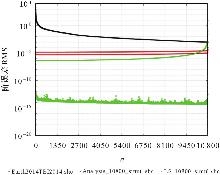
Fig. 1
The degree error RMS of different methods"
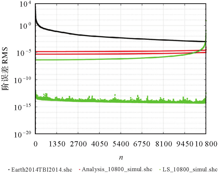
Fig. 2
Model coefficient errors for the first 100 degrees of when m=0"
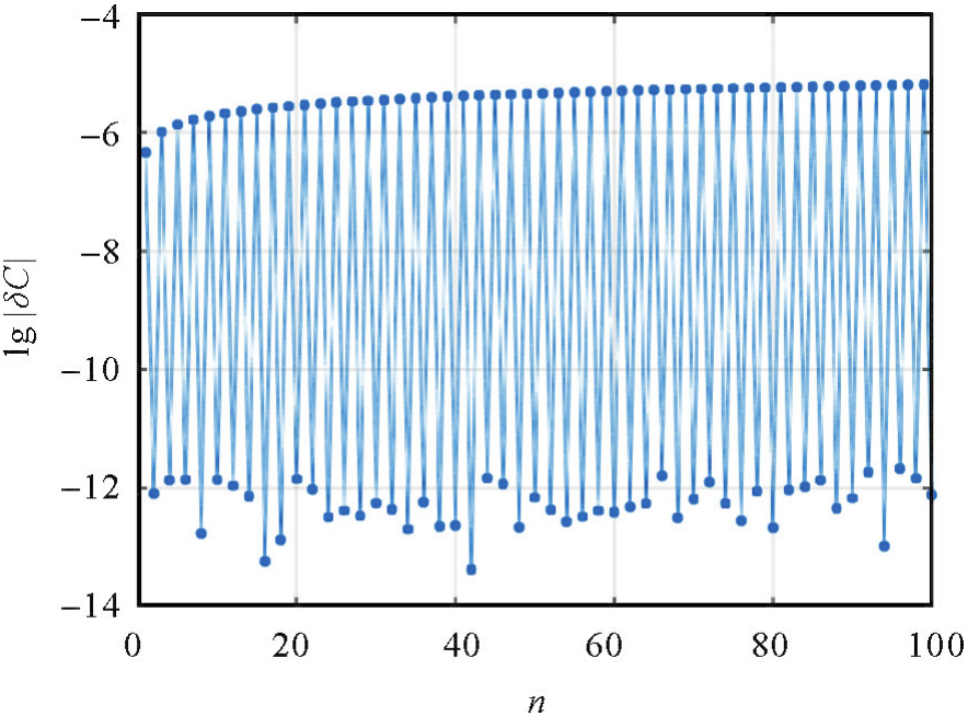
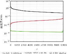
Fig. 3
The coefficient errors in the case of m≠0"
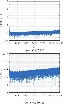
Fig. 4
The coefficient errors of LS_10800_simul.shc in the case of n=10 800"

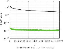
Fig. 5
The coefficient errors of LS_10799_simul.shc"

Tab. 1
Errors of different models compared with Earth2014-TBI2014.shcm"
| 模型 | 最大值 | 最小值 | 平均值 | RMS |
|---|---|---|---|---|
| Analysis_10800_simul.shc | 514.7 | -1 071.2 | -0.04 | 11.8 |
| LS_10800_simul.shc | 2.3×10⁻⁹ | -2.4×10⁻⁹ | 1.3×10⁻¹² | 4.2×10⁻¹¹ |
Tab. 2
Differences between grid terrain calculated by different models and Earth2014. TBI2014.1min.geod.grd"
| 模型 | 最大值/m | 最小值/m | 平均值/m | std/m | ≤std的比例/(%) | ≤2std的比例/(%) | ≤3std的比例/(%) |
|---|---|---|---|---|---|---|---|
| LS_10800.shc | 1 698.60 | -1 849.17 | 0.00 | 9.31 | 92.51 | 96.55 | 98.05 |
| Earth2014TBI2014.shc | 1 606.91 | -1 837.77 | -0.006 | 10.15 | 92.51 | 96.45 | 97.97 |
Tab. 3
Accuracy of different models in China and surrounding regions"
| 模型 | 误差最大值/m | 误差最小值/m | 误差平均值/m | 误差std/m | ≤std的比例/(%) | ≤2std的比例/(%) | ≤3std的比例/(%) |
|---|---|---|---|---|---|---|---|
| LS_10800.shc | 354.98 | -376.87 | 0.000 3 | 18.79 | 86.49 | 94.41 | 97.38 |
| Earth2014TBI2014.shc | 428.68 | -409.46 | 0.000 9 | 20.69 | 86.52 | 94.34 | 97.34 |
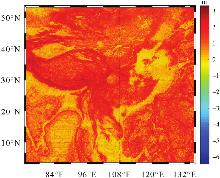
Fig. 6
Terrain difference between adjacent grids in the northsouth direction in China and surrounding regions"

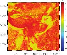
Fig. 7
Terrain difference between adjacent grids in the eas-t west direction in China and surrounding regions"

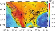
Fig. 8
Distribution of GPS points"
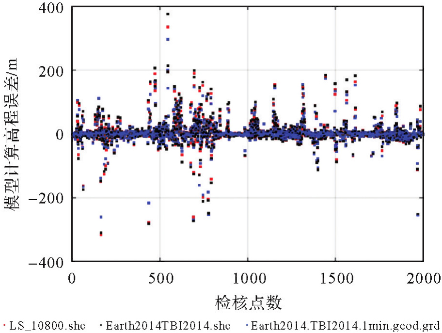
Fig. 9
Residuals between different models and GPS points"
Tab. 4
Errors compared with GPS points"
| 模型 | 最大值/m | 最小值/m | 平均值/m | std/m | ≤mean+std的比例/(%) | ≤mean+2std的比例/(%) | ≤mean+3std的比例/(%) |
|---|---|---|---|---|---|---|---|
| LS_10800.shc | 334.51 | -316.26 | 2.86 | 32.85 | 89.55 | 95.15 | 97.70 |
| Earth2014TBI2014.shc | 374.91 | -309.83 | 3.27 | 34.38 | 89.55 | 95.20 | 97.65 |
| Earth2014. TBI2014.1min.geod.grd | 296.24 | -268.22 | 2.28 | 29.53 | 89.70 | 95.40 | 97.55 |
Tab. 5
Accuracy for different regions"
| 模型 | 区域 | 最大值/m | 最小值/m | 平均值/m | std/m | ≤mean+std的比例/(%) | ≤mean+2std的比例/(%) | ≤mean+3std的比例/(%) |
|---|---|---|---|---|---|---|---|---|
| LS_10800.shc | 山区 | 334.51 | -277.34 | 6.33 | 44.29 | 87.18 | 95.06 | 97.41 |
| 平原 | 163.25 | -316.26 | 0.29 | 20.32 | 89.65 | 96.70 | 98.09 | |
| Earth2014TBI2014.shc | 山区 | 374.91 | -281.42 | 7.23 | 46.60 | 87.76 | 95.06 | 97.18 |
| 平原 | 181.78 | -309.83 | 0.34 | 20.78 | 89.04 | 96.43 | 98.09 | |
| Earth2014. TBI2014.1min.geod.grd | 山区 | 296.24 | -268.22 | 5.12 | 39.74 | 88.24 | 95.18 | 97.53 |
| 平原 | 152.68 | -260.57 | 0.17 | 18.42 | 88.61 | 96.17 | 98.09 |
| [1] | 单建晨. 超(甚)高阶全球地形球谐系数模型的构建[D]. 郑州: 信息工程大学, 2022. |
| SHAN Jianchen. Construction of ultra-high-degree spherical harmonic model of the earth topography[D]. Zhengzhou: Information Engineering University, 2022. | |
| [2] | 单建晨, 李姗姗, 范雕, 等. 基于调和分析法的全球地形球谐系数模型构建[J]. 中国惯性技术学报, 2022, 30(1): 29-36. |
| SHAN Jianchen, LI Shanshan, FAN Diao, et al. Constructing spherical harmonic model of Earth topography based on harmonic analysis methods[J]. Journal of Chinese Inertial Technology, 2022, 30(1): 29-36. | |
| [3] |
单建晨, 李姗姗, 范雕, 等. 超高阶全球地形球谐系数模型的构建方法与实现[J]. 测绘学报, 2023, 52(5): 748-759. DOI: .
doi: 10.11947/j.AGCS.2023.20220003 |
|
SHAN Jianchen, LI Shanshan, FAN Diao, et al. Design and implementation of ultra-high-degree spherical harmonic model of earth topography[J]. Acta Geodaetica et Cartographica Sinica, 2023, 52(5): 748-759. DOI: .
doi: 10.11947/j.AGCS.2023.20220003 |
|
| [4] | YANG Meng. Investigation of the residual terrain modelling (RTM) technique for high-frequency gravity calculations[D]. Munich: Technical University of Munich, 2020. |
| [5] | HIRT C, REXER M, CLAESSENS S, et al. The relation between degree-2160 spectral models of Earth's gravitational and topographic potential: a guide on global correlation measures and their dependency on approximation effects[J]. Journal of Geodesy, 2017, 91(10): 1179-1205. |
| [6] | HIRT C, FEATHERSTONE W E, MARTI U. Combining EGM2008 and SRTM/DTM2006.0 residual terrain model data to improve quasigeoid computations in mountainous areas devoid of gravity data[J]. Journal of Geodesy, 2010, 84(9): 557-567. |
| [7] | 李军, 欧阳明达, 李琦. 利用EGM2008+DTM2006.0模型精化区域似大地水准面[J]. 大地测量与地球动力学, 2018, 38(3): 244-248. |
| LI Jun, OUYANG Mingda, LI Qi. Refinement of regional quasi-geoid using the EGM2008+DTM2006.0 model[J]. Journal of Geodesy and Geodynamics, 2018, 38(3): 244-248. | |
| [8] | 陈良. 剩余地形模型在高程异常计算中的适用性分析[D]. 成都: 西南交通大学, 2023. |
| CHEN Liang. Applicability analysis of residual terrain model in height anomaly calculation[D]. Chengdu: Southwest Jiaotong University, 2023. | |
| [9] | 张兴福, 刘成. 综合EGM2008模型和SRTM/DTM2006.0剩余地形模型的GPS高程转换方法[J]. 测绘学报, 2012, 41(1): 25-32. |
| ZHANG Xingfu, LIU Cheng. The approach of GPS height transformation based on EGM2008 and SRTM/DTM2006.0 residual terrain model[J]. Acta Geodaetica et Cartographica Sinica, 2012, 41(1): 25-32. | |
| [10] | HIRT C, BUCHA B, YANG Meng, et al. A numerical study of residual terrain modelling (RTM) techniques and the harmonic correction using ultra-high-degree spectral gravity modelling[J]. Journal of Geodesy, 2019, 93(9): 1469-1486. |
| [11] | PAVLIS N K, FACTOR J K, HOLMES S A. Terrain-related gravimetric quantities computed for the next EGM[C]//Proceedings of the 1st International Symposium of the International Gravity Field Service. Istanbul: [s.n.], 2007: 318-323. |
| [12] | HIRT C, REXER M. Earth2014: 1 arc-min shape, topography, bedrock and ice-sheet models-Available as gridded data and degree-10 800 spherical harmonics[J]. International Journal of Applied Earth Observation and Geoinformation, 2015, 39: 103-112. |
| [13] | HIRT C. RTM gravity forward-modeling using topography/bathymetry data to improve high-degree global geopotential models in the coastal zone[J]. Marine Geodesy, 2013, 36(2): 183-202. |
| [14] | YANG Meng, HIRT C, PAIL R, et al. TGF: a new MATLAB-based software for terrain-related gravity field calculations[J]. Remote Sensing, 2020, 12(7): 1062-1083. |
| [15] | REXER M, HIRT C. Ultra-high-degree surface spherical harmonic analysis using the Gauss-Legendre and the driscoll/Healy quadrature theorem and application to planetary topography models of Earth, Mars and Moon[J]. Surveys in Geophysics, 2015, 36(6): 803-830. |
| [16] | 罗志才, 钟波, 宁津生, 等. 卫星重力梯度测量确定地球重力场的理论与方法[M]. 武汉: 武汉大学出版社, 2015. |
| LUO Zhicai, ZHONG Bo, NING Jinsheng, et al. Theory and method for determining the Earth's gravity field from satellite gravity gradiometry[M]. Wuhan: Wuhan University Press, 2015. | |
| [17] | LEMOINE F, KENYON S C, FACTOR J, et al. The development of the joint NASA GSFC and the National Imagery and Mapping Agency (NIMA) geopotential model EGM96[R]. Washington, D. C.: NASA Goddard Space Flight Center, 1998. |
| [18] | COLOMBO O L. Numerical methods for harmonic analysis on the sphere[R]. Columbus: Ohio State University, 1981. |
| [19] | 邢志斌. GOCE卫星重力梯度数据恢复地球重力场理论与方法研究[D]. 郑州: 信息工程大学, 2019. |
| XING Zhibin. Research on theory and methodology of earth gravity field recovery based on GOCE gravity gradient data[D]. Zhengzhou: Information Engineering University, 2019. | |
| [20] | 李新星, 吴晓平, 李姗姗, 等. 块对角最小二乘方法在确定全球重力场模型中的应用[J]. 测绘学报, 2014, 43(8): 778-785. |
| LI Xinxing, WU Xiaoping, LI Shanshan, et al. The application of block-diagonal least-squares methods in geopotential model determination[J]. Acta Geodaetica et Cartographica Sinica, 2014, 43(8): 778-785. | |
| [21] |
田家磊, 李新星, 吴晓平, 等. 超高阶重力场模型最小二乘快速实现[J]. 测绘学报, 2018, 47(11): 1437-1445. DOI: .
doi: 10.11947/j.AGCS.2018.20170659 |
|
TIAN Jialei, LI Xinxing, WU Xiaoping, et al. Fast realization of ultra-high-degree geopotential model by improved least-squares method[J]. Acta Geodaetica et Cartographica Sinica, 2018, 47(11): 1437-1445. DOI: .
doi: 10.11947/j.AGCS.2018.20170659 |
|
| [22] | 梁伟. 超高阶地球重力场模型构建理论与方法的研究[D]. 武汉: 武汉大学, 2021. |
| LIANG Wei. Study of the theories and methods on the development of Earth's gravity field model with ultra-high degree and order[D]. Wuhan: Wuhan University, 2021. | |
| [23] | 李建成, 徐新禹, 赵永奇, 等. 由GOCE引力梯度张量不变量确定卫星重力模型的半解析法[J]. 武汉大学学报(信息科学版), 2016, 41(1): 21-26. |
| LI Jiancheng, XU Xinyu, ZHAO Yongqi, et al. Approach for determining satellite gravity model from GOCE gravitational gradient tensor invariant observations[J]. Geomatics and Information Science of Wuhan University, 2016, 41(1): 21-26. | |
| [24] | 邢志斌, 李姗姗, 田苗, 等. 重力梯度向量化调和分析的FFT算法[J]. 测绘科学技术学报, 2021, 38(4): 355-360. |
| XING Zhibin, LI Shanshan, TIAN Miao, et al. The FFT algorithm for vectorization harmonic analysis method of gravity gradient[J]. Journal of Geomatics Science and Technology, 2021, 38(4): 355-360. | |
| [25] | XING Zhibin, LI Shanshan, TIAN Miao, et al. Numerical experiments on column-wise recurrence formula to compute fully normalized associated Legendre functions of ultra-high degree and order[J]. Journal of Geodesy, 2019, 94(1): 2. |
| [26] | FUKUSHIMA T. Numerical computation of spherical harmonics of arbitrary degree and order by extending exponent of floating point numbers[J]. Journal of Geodesy, 2012, 86(4): 271-285. |
| [1] | . The Application of Block-diagonal Least-squares Methods in Geopotential Model Determination [J]. Acta Geodaetica et Cartographica Sinica, 2014, 43(8): 778-785. |
| Viewed | ||||||
|
Full text |
|
|||||
|
Abstract |
|
|||||