

Acta Geodaetica et Cartographica Sinica ›› 2026, Vol. 55 ›› Issue (1): 25-35.doi: 10.11947/j.AGCS.2026.20250069
• Geodesy and Navigation • Previous Articles Next Articles
Qingzhi ZHAO1( ), Duoduo JIANG1, Yibin YAO2, Zhi MA1, Yongjie MA1, Haojie LI1, Ruirui XUE1
Received:2025-02-25
Revised:2025-06-18
Online:2026-02-13
Published:2026-02-13
About author:ZHAO Qingzhi (1989—), male, PhD, professor, majors in GNSS data processing and its innovative application. E-mail: zhaoqingzhia@163.com
Supported by:CLC Number:
Qingzhi ZHAO, Duoduo JIANG, Yibin YAO, Zhi MA, Yongjie MA, Haojie LI, Ruirui XUE. An adaptive method for selecting the optimal GNSS satellite signal for water vapor tomography[J]. Acta Geodaetica et Cartographica Sinica, 2026, 55(1): 25-35.
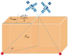
Fig. 1
Satellite signal coverage range under different average station spacings of GNSS stations"
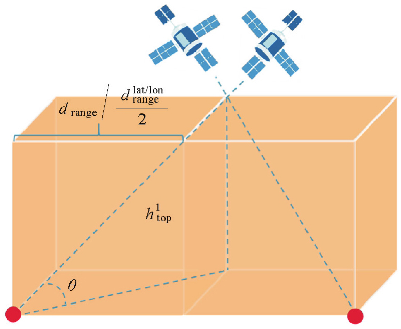
Fig. 2
GNSS signal adaptive optimization theory"

Fig. 3
Geographic distribution of GNSS stations and radiosonde in Hong Kong SatRef"
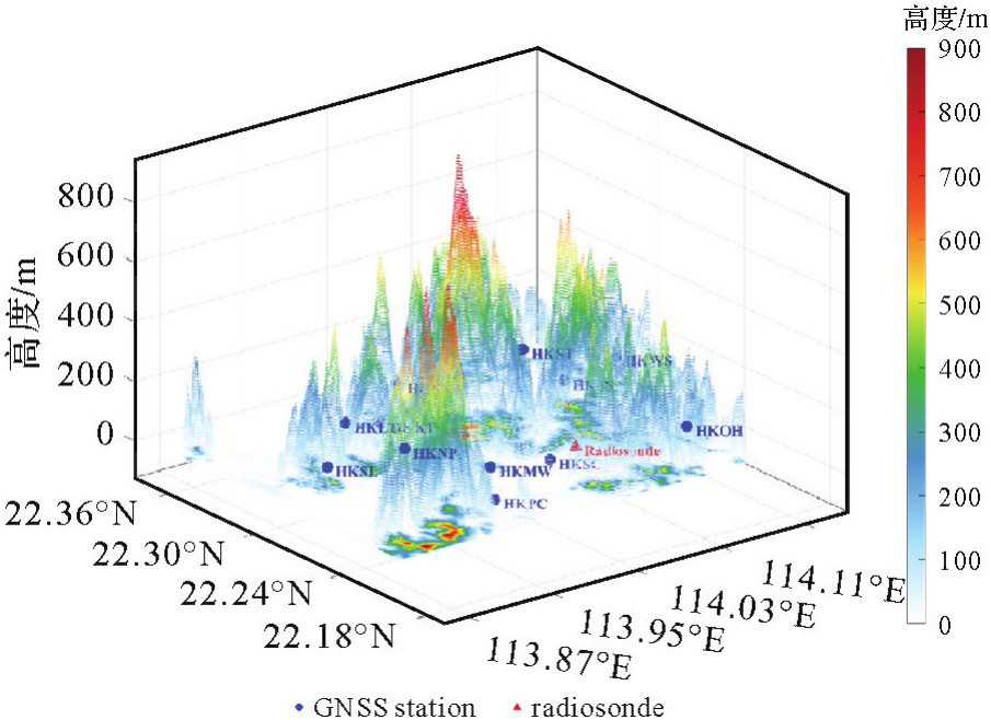
Fig. 4
Comparison of ray utilization, grid coverage, and matrix rank between different tomography schemes"
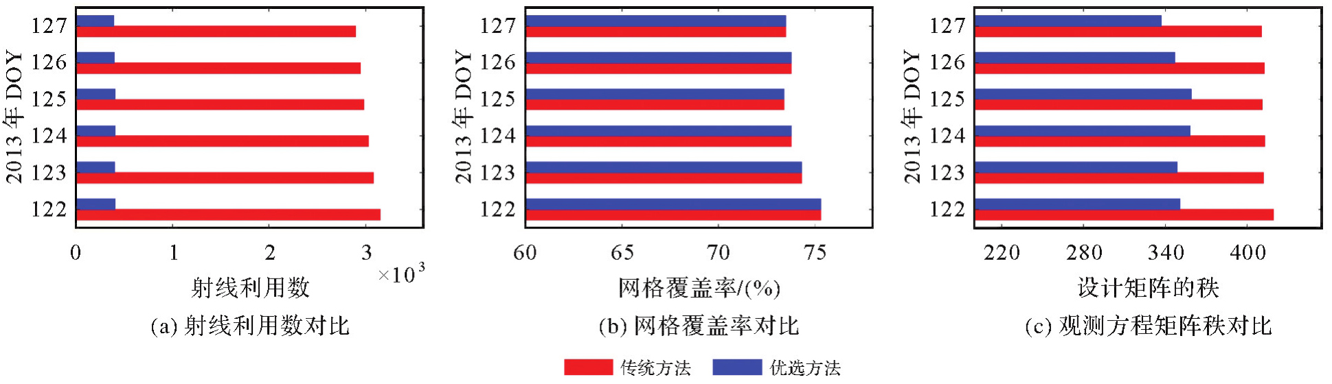
Fig. 5
Comparison of water vapor density profiles inverted by different methods in special epochs with radiosonde data"
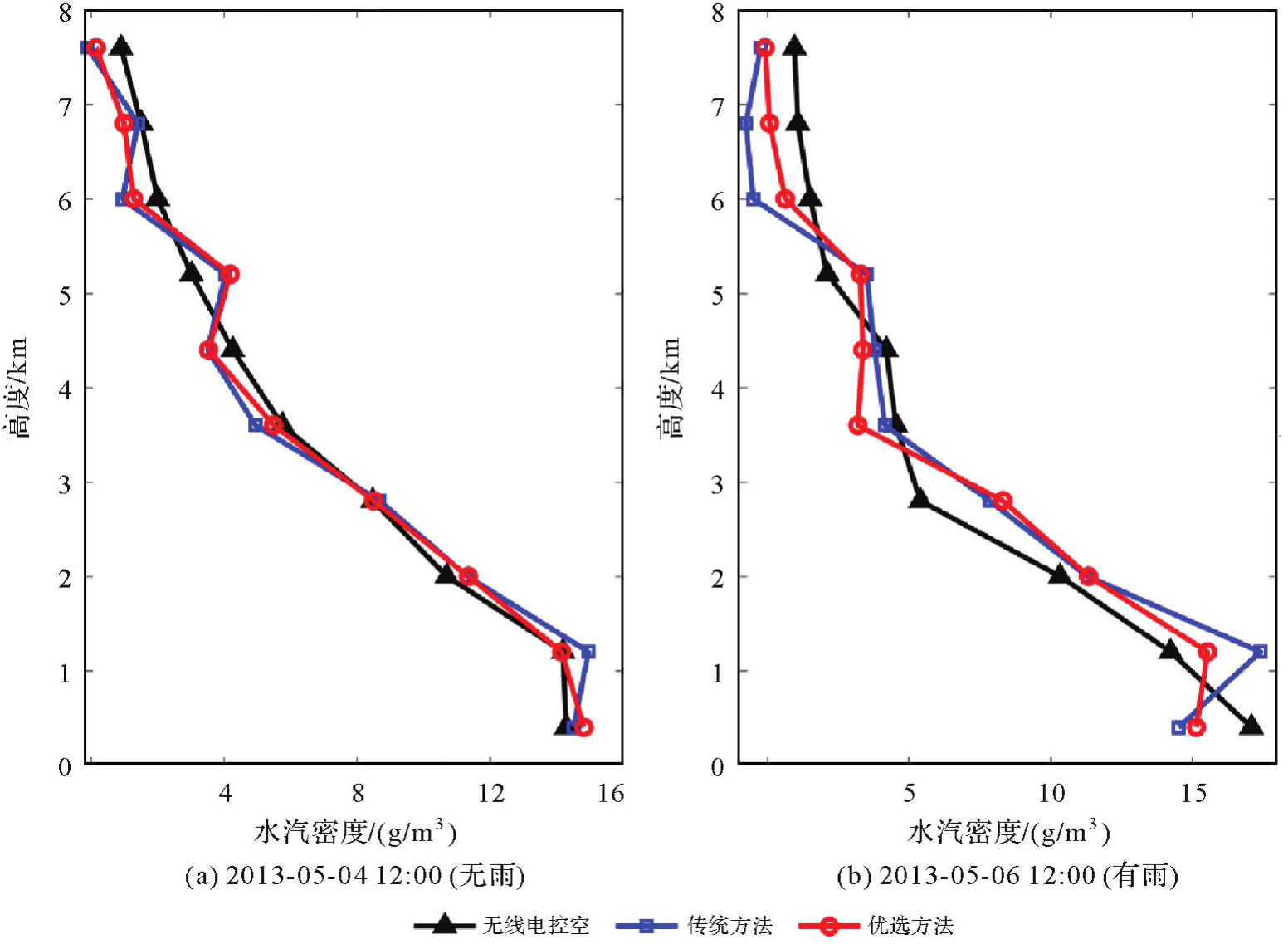
Fig. 6
Comparison of 3D water vapor density distributions retrieved by different schemes in special epochs"
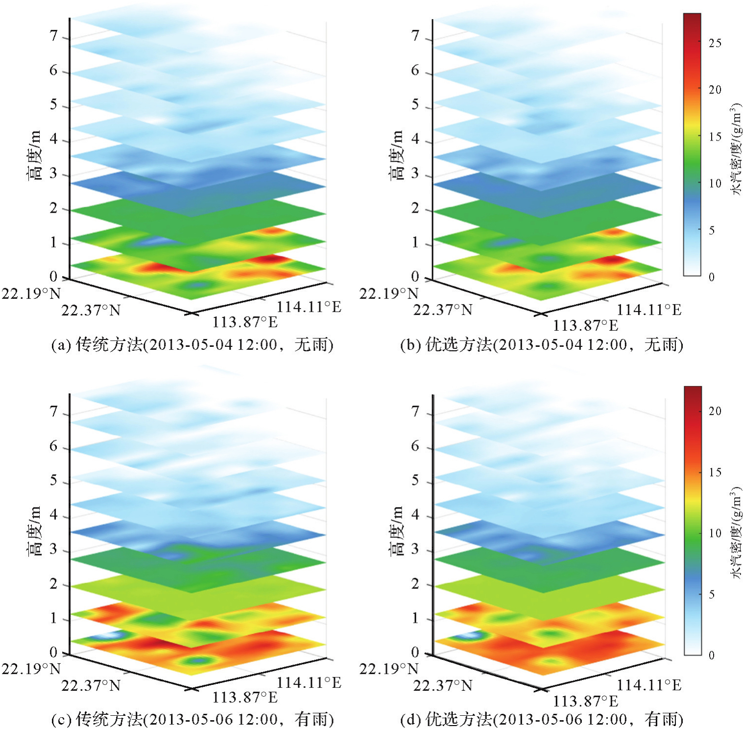
Fig. 7
Comparison of accuracy indicators between different tomography schemes and radiosonde data"

Fig. 8
Variation of water vapor retrieval accuracy with height for different schemes"
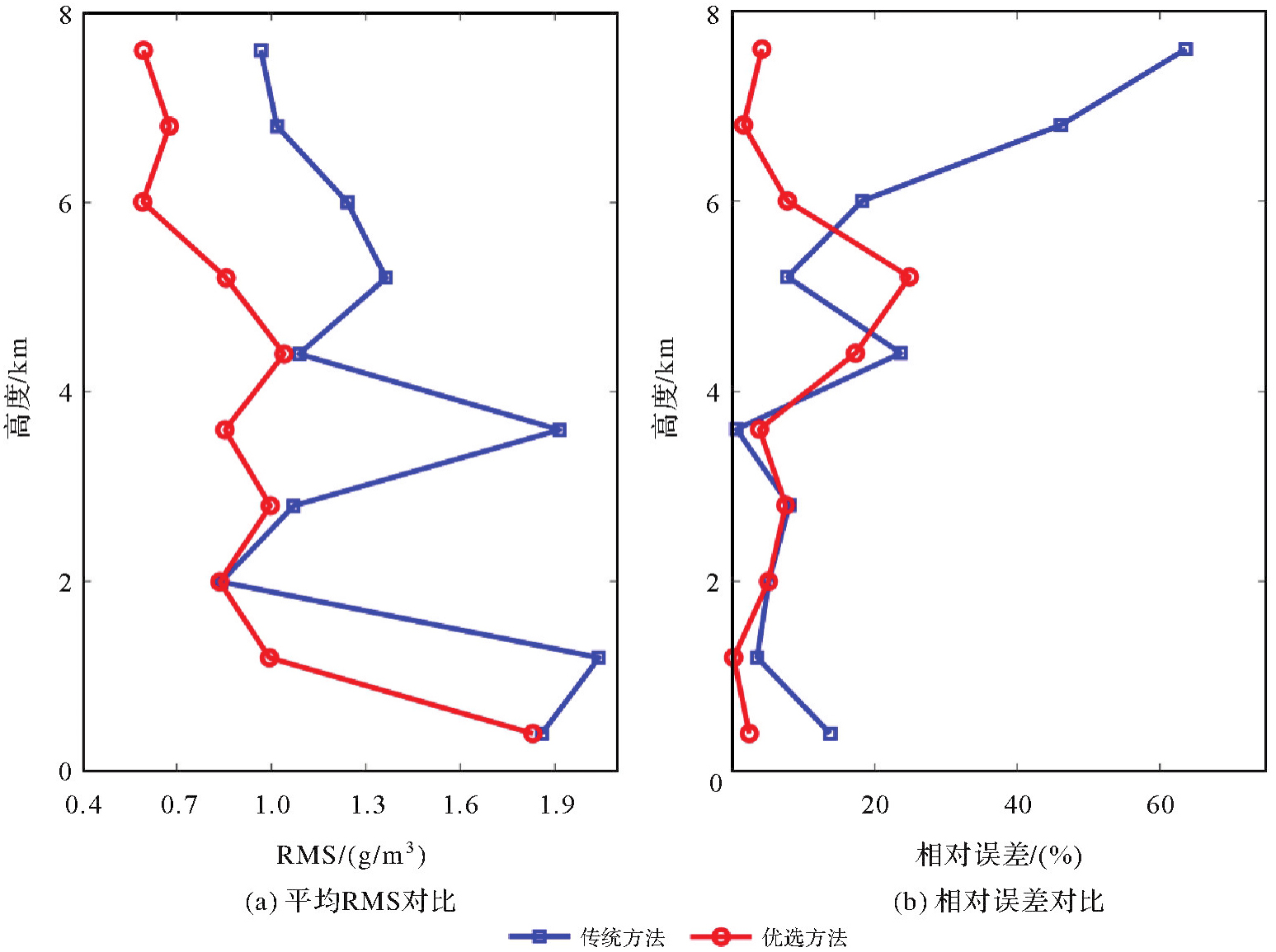
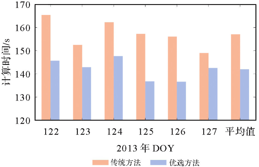
Fig. 9
Comparison of model computing time between traditional and optimal methods from May 2, 2013 to May 7, 2013"
| [1] | YAO Yibin, YANG Yuanxi, SUN Heping, et al. Geodesy discipline: progress and perspective[J]. Journal of Geodesy and Geoinformation Science, 2021, 4(4): 1-10. |
| [2] | TRZCINA E, ROHM W. Estimation of 3D wet refractivity by tomography, combining GNSS and NWP data: first results from assimilation of wet refractivity into NWP[J]. Quarterly Journal of the Royal Meteorological Society, 2019, 145(720): 1034-1051. |
| [3] | YAO Yibin, SUN Zhangyu, XU Chaoqian. Applicability of Bevis formula at different height levels and global weighted mean temperature model based on near-earth atmospheric temperature[J]. Journal of Geodesy and Geoinformation Science, 2020, 3(1): 1-11. |
| [4] |
张克非, 李浩博, 王晓明, 等. 地基GNSS大气水汽探测遥感研究进展和展望[J]. 测绘学报, 2022, 51(7): 1172-1191. DOI: .
doi: 10.11947/j.AGCS.2022.20220149 |
|
ZHANG Kefei, LI Haobo, WANG Xiaoming, et al. Recent progresses and future prospectives of ground-based GNSS water vapor sounding[J]. Acta Geodaetica et Cartographica Sinica, 2022, 51(7): 1172-1191. DOI: .
doi: 10.11947/j.AGCS.2022.20220149 |
|
| [5] | 丁楠. 地基GNSS水汽层析关键技术研究[D]. 徐州: 中国矿业大学, 2018. |
| DING Nan. Research on the key technologies of ground based GNSS water vapor tomography[D]. Xuzhou: China University of Mining and Technology, 2018. | |
| [6] | BRAUN J, ROCKEN C, MEERTENS C, et al. Development of a water vapor tomography system using low cost L1 GPS receivers[C]//Proceedings of the 9th ARM Science Team Meeting. San Antonio: US Department of Energy, 1999: 22-26. |
| [7] | FLORES A, RUFFINI G, RIUS A. 4D tropospheric tomography using GPS slant wet delays[J]. Annales Geophysicae, 2000, 18(2): 223-234. |
| [8] | 赵庆志. 地基GNSS水汽反演关键技术研究及其应用[D]. 武汉: 武汉大学, 2017. |
| ZHAO Qingzhi. Studies on the key technologies in water vapor inversion using ground-based GNSS and its applications[D]. Wuhan: Wuhan University, 2017. | |
| [9] | 张文渊, 张书毕, 郑南山, 等. 联合GNSS/RS多源数据反演三维大气水汽分布研究[J]. 地球物理学报, 2022, 65(6): 1951-1964. |
| ZHANG Wenyuan, ZHANG Shubi, ZHENG Nanshan, et al. Study on the retrieval of 3D atmospheric water vapor distribution using GNSS and RS multi-source data[J]. Chinese Journal of Geophysics, 2022, 65(6): 1951-1964. | |
| [10] | 姚秀光, 郭金城, 严梦琪, 等. 基于地基GNSS观测数据的贵州高原地区水汽层析精度分析[J]. 大地测量与地球动力学, 2023, 43(11): 1162-1166. |
| YAO Xiuguang, GUO Jincheng, YAN Mengqi, et al. Accuracy analysis of water vapor chromatography in Guizhou Plateau based on ground-based GNSS observation data[J]. Journal of Geodesy and Geodynamic, 2023, 43(11): 1162-1166. | |
| [11] |
王昊, 丁楠, 张文渊, 等. GNSS水汽层析的自适应非均匀指数分层方法[J]. 测绘学报, 2022, 51(3): 327-339. DOI: .
doi: 10.11947/j.AGCS.2022.20210126 |
|
WANG Hao, DING Nan, ZHANG Wenyuan, et al. An adaptive non-uniform vertical stratification for GNSS water vapor tomography[J]. Acta Geodaetica et Cartographica Sinica, 2022, 51(3): 327-339. DOI: .
doi: 10.11947/j.AGCS.2022.20210126 |
|
| [12] |
张文渊, 戚铭心, 张书毕. 顾及水汽分布的非均匀离散化GNSS水汽层析精化方法[J]. 测绘学报, 2024, 53(12): 2282-2294. DOI: .
doi: 10.11947/j.AGCS.2024.20220534 |
|
ZHANG Wenyuan, QI Mingxin, ZHANG Shubi. A non-uniform discretization GNSS water vapor tomography refined method considering water vapor distributions[J]. Acta Geodaetica et Cartographica Sinica, 2024, 53(12): 2282-2294. DOI: .
doi: 10.11947/j.AGCS.2024.20220534 |
|
| [13] | PERLER D, GEIGER A, HURTER F. 4D GPS water vapor tomography: new parameterized approaches[J]. Journal of Geodesy, 2011, 85(8): 539-550. |
| [14] | DING Nan, ZHANG Shubi, WU Suqin, et al. Adaptive node parameterization for dynamic determination of boundaries and nodes of GNSS tomographic models[J]. Journal of Geophysical Research: Atmospheres, 2018, 123(4): 1990-2003. |
| [15] | ZHAO Qingzhi, YAO Yibin, YAO Wanqiang. Troposphere water vapour tomography: a horizontal parameterised approach[J]. Remote Sensing, 2018, 10(8): 1241. |
| [16] | ZHANG Wenyuan, ZHANG Shubi, MOELLER G, et al. An adaptive-degree layered function-based method to GNSS tropospheric tomography[J]. GPS Solutions, 2023, 27(2): 67. |
| [17] | 赵庆志, 姚宜斌, 罗亦泳. 附加辅助层析区域提高射线利用率的水汽反演方法[J]. 武汉大学学报(信息科学版), 2017, 42(9): 1203-1208, 1222. |
| ZHAO Qingzhi, YAO Yibin, LUO Yiyong. A method to improve the utilization of observation for water vapor tomography by adding assisted tomographic area[J]. Geomatics and Information Science of Wuhan University, 2017, 42(9): 1203-1208, 1222. | |
| [18] | YAO Yibin, ZHAO Qingzhi. Maximally using GPS observation for water vapor tomography[J]. IEEE Transactions on Geoscience and Remote Sensing, 2016, 54(12): 7185-7196. |
| [19] | YAO Yibin, ZHAO Qingzhi, ZHANG Bao. A method to improve the utilization of GNSS observation for water vapor tomography[J]. Annales Geophysicae, 2016, 34(1): 143-152. |
| [20] | LIU Shangyi, ZHANG Kefei, WU Suqin, et al. An improved GNSS tropospheric tomographic model with an extended region and combining virtual signals[J]. Atmospheric Research, 2023, 287: 106703. |
| [21] | ASKNE J, NORDIUS H. Estimation of tropospheric delay for microwaves from surface weather data[J]. Radio Science, 1987, 22(3): 379-386. |
| [22] | BEVIS M, BUSINGER S, CHISWELL S, et al. GPS meteorology: mapping zenith wet delays onto precipitable water[J]. Journal of Applied Meteorology, 1994, 33(3): 379-386. |
| [23] | YAO Yibin, SUN Zhangyu, XU Chaoqian. Applicability of Bevis formula at different height levels and global weighted mean temperature model based on near-earth atmospheric temperature[J]. Journal of Geodesy and Geoinformation Science, 2020, 3(1): 1-11. |
| [24] | ROHM W. The ground GNSS tomography-unconstrained approach[J]. Advances in Space Research, 2013, 51(3): 501-513. |
| [25] | 宋淑丽, 朱文耀, 丁金才, 等. 上海GPS网层析水汽三维分布改善数值预报湿度场[J]. 科学通报, 2005, 50(20): 2271-2277. |
| SONG Shuli, ZHU Wenyao, DING Jincai, et al. Improve the accuracy of the humidity field from numerical weather prediction model using the three-dimensional water vapor tomography result in Shanghai GNSS network[J]. Chinese Science Bulletin, 2005, 50(20): 2271-2277. | |
| [26] | 王维, 王解先. 基于代数重构技术的对流层水汽层析[J]. 计算机应用, 2011, 31(11): 3149-3151. |
| WANG Wei, WANG Jiexian. Ground-based GPS water vapor tomography based on algebraic reconstruction technique[J]. Journal of Computer Applications, 2011, 31(11): 3149-3151. | |
| [27] |
王维, 宋淑丽, 王解先, 等. 长三角地区多模GNSS斜路径观测分布及水汽仿真层析[J]. 测绘学报, 2016, 45(2): 164-169. DOI: .
doi: 10.11947/j.AGCS.2016.20140648 |
|
WANG Wei, SONG Shuli, W ANG Jiexian, et al. Distribution analysis of multi-GNSS slant delays and simulated water vapor tomography in Yangtze River Delta[J]. Acta Geodaetica et Cartographica Sinica, 2016, 45(2): 164-169. DOI: .
doi: 10.11947/j.AGCS.2016.20140648 |
|
| [28] | CAO Yunchang, CHEN Yongqi, LI Pingwha. Wet refractivity tomography with an improved Kalman-filter method[J]. Advances in Atmospheric Sciences, 2006, 23(5): 693-699. |
| [29] | ZHAO Qingzhi, LI Zufeng, YAO Wanqiang, et al. An improved ridge estimation (IRE) method for troposphere water vapor tomography[J]. Journal of Atmospheric and Solar-Terrestrial Physics, 2020, 207: 105366. |
| [30] | CHANG K T. Introduction to geographic information systems[M]. Boston: McGraw-Hill, 2008. |
| [1] | Jinwei BU, Shuhui LIU, Shunshuang XU, Tongsu XIANG, Qiulan WANG, Chaoying JI, Xiaoqing ZUO. Construction of an empirical model for estimating the global wave period of spaceborne GNSS-R [J]. Acta Geodaetica et Cartographica Sinica, 2026, 55(4): 684-697. |
| [2] | Tangting WU, Xinyu LUO, Liguo LU, Zhanke LIU, Nengfang CHAO. Assessment of water resource changes and drought characteristics in the Shaanxi, Gansu and Ningxia region based on GNSS and GRACE/GRACE-FO [J]. Acta Geodaetica et Cartographica Sinica, 2026, 55(3): 439-450. |
| [3] | Zhongmin MA, Shuangcheng ZHANG, Xin ZHOU, Qi LIU, Ning LIU, Hengli WANG. A flood monitoring method using FY-3 GNSS-R accounting for surface reflectivity uncertainty: a case study of the August 2 Guangdong rainstorm disaster [J]. Acta Geodaetica et Cartographica Sinica, 2026, 55(3): 451-464. |
| [4] | Qingyun YAN, Zixuan GUO, Yuanjin PAN, Yan JIA, Shuanggen JIN. Quantitative driving factors and zoning patterns of GNSS-R land surface reflectivity spatial heterogeneity [J]. Acta Geodaetica et Cartographica Sinica, 2026, 55(2): 315-327. |
| [5] | Deying YU, Houpu LI, Yi LIU, Shuguang WU, Deyan LI, Mingchao LI, Wenkui LI, Shaofeng BIAN. A DBSCAN-based RAIM algorithm for multiple gross error identification [J]. Acta Geodaetica et Cartographica Sinica, 2026, 55(1): 59-72. |
| [6] | Dongliang CHENG, Lingqiu CHEN, Zhiyong HUANG, Shubo QIAO, Dandan WANG, Yaming YAN. Performance evaluation of COATS-based multi-mode and multi-frequency iGNSS-R altimetry [J]. Acta Geodaetica et Cartographica Sinica, 2026, 55(1): 73-89. |
| [7] | Yarong LUO, Wentao LU, Chi GUO, Jingnan LIU. Left-handed symmetry equivariant filtering model and algorithm for GNSS/INS integrated navigation [J]. Acta Geodaetica et Cartographica Sinica, 2025, 54(8): 1389-1403. |
| [8] | Yangyi CHEN, Kai ZHENG, Xiaohong ZHANG, Mingkui WU, Pengxu WANG, Wenju FU, Kezhong LIU. GPS/Galileo/BDS overlapping frequencies multipath error analysis and modeling [J]. Acta Geodaetica et Cartographica Sinica, 2025, 54(8): 1427-1438. |
| [9] | Jianzhang LI, Haowen YAN, Weifang YANG, Xiaoning SU. GNSS pseudo trigonometric leveling method [J]. Acta Geodaetica et Cartographica Sinica, 2025, 54(7): 1170-1177. |
| [10] | Qingzhi ZHAO, Lulu CHANG, Yibin YAO, Haojie LI. A method for constructing a hydrological drought index integrated with GNSS and meteorological data [J]. Acta Geodaetica et Cartographica Sinica, 2025, 54(7): 1192-1205. |
| [11] | Qianxin WANG, Chao HU, Tong CHENG. A method for satellite ultra-rapid orbit and clock offset estimation based on the prior information of the GNSS clock parameters [J]. Acta Geodaetica et Cartographica Sinica, 2025, 54(6): 982-994. |
| [12] | Yang SHEN, Guangyun LI, Mingjian CHEN, Linyang LI, Xingyu SHI, Wei CAI, Weifeng HAO. Assessment of GNSS ionosphere models based on FY-3 TEC in polar regions [J]. Acta Geodaetica et Cartographica Sinica, 2025, 54(6): 995-1008. |
| [13] | Shunqiang HU, Kejie CHEN, Xiaoxing HE, Hai ZHU, Tan WANG. The impact of environmental loading on nonlinear variations of 3D coordinate time series of GNSS stations in Sichuan and Yunnan region [J]. Acta Geodaetica et Cartographica Sinica, 2025, 54(5): 805-818. |
| [14] | Wentao YANG, Fei GUO, Xiaohong ZHANG, Zhiyu ZHANG, Yifan ZHU, Zheng LI, Ziheng WU. Soil moisture and freeze-thaw map using GNSS reflectometer and SMAP radiometer for Qinghai-Xizang Plateau [J]. Acta Geodaetica et Cartographica Sinica, 2025, 54(4): 725-735. |
| [15] | Qingzhi ZHAO, Duoduo JIANG, Hongwu GUO, Zufeng LI, Chen LIU, Yibin YAO. A general method for determining the key parameters of GNSS water vapor tomography modeling [J]. Acta Geodaetica et Cartographica Sinica, 2025, 54(3): 410-421. |
| Viewed | ||||||
|
Full text |
|
|||||
|
Abstract |
|
|||||