

Acta Geodaetica et Cartographica Sinica ›› 2025, Vol. 54 ›› Issue (5): 805-818.doi: 10.11947/j.AGCS.2025.20240397
• Geodesy and Navigation • Previous Articles Next Articles
Shunqiang HU1( ), Kejie CHEN2,3(), Xiaoxing HE4, Hai ZHU2, Tan WANG5
Received:2024-09-23
Revised:2025-04-11
Online:2025-06-23
Published:2025-06-23
Contact:
Kejie CHEN
E-mail:husq@jxnu.edu.cn;chenkj@sustech.edu.cn
About author:HU Shunqiang (1991—), male, PhD, majors in GNSS coordinate time series analysis. E-mail: husq@jxnu.edu.cn
Supported by:CLC Number:
Shunqiang HU, Kejie CHEN, Xiaoxing HE, Hai ZHU, Tan WANG. The impact of environmental loading on nonlinear variations of 3D coordinate time series of GNSS stations in Sichuan and Yunnan region[J]. Acta Geodaetica et Cartographica Sinica, 2025, 54(5): 805-818.
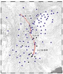
Fig. 1
The distribution of 94 GNSS stations in Sichuan and Yunnan region"
Tab. 1
Model parameters for hydrological, atmospheric, and non-tidal ocean loading products under GFZ and IMLS"
| 机构 | 负载类型 | 模型 | 空间分辨率 | 时间分辨率/h |
|---|---|---|---|---|
| GFZ | 水文负载 | LSDM | 24 | |
| 大气负载 | ECMWF | 0.5°×0.5° | 3 | |
| 非潮汐海洋负载 | EMPIOM | 3 | ||
| IMLS | 水文负载 | MERRA2 | 3 | |
| 大气负载 | MERRA2 | 2′×2′ | 6 | |
| 非潮汐海洋负载 | MPIOM06 | 3 |
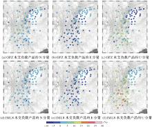
Fig. 2
PRMS results of GNSS 3D coordinate time series corrected by hydrological loading products under GFZ and IMLS"

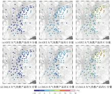
Fig. 3
PRMS results of GNSS 3D coordinate time series corrected by atmospheric loading products under GFZ and IMLS"

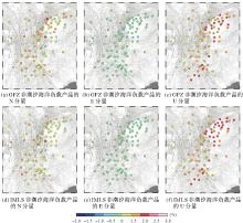
Fig. 4
PRMS results of GNSS 3D coordinate time series corrected by non-tidal ocean loading products under GFZ and IMLS"

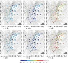
Fig. 5
PRMS results of GNSS 3D coordinate time series corrected by combined environmental loads (sum of hydrological, atmospheric and non-tidal ocean loading) products under GFZ and IMLS"

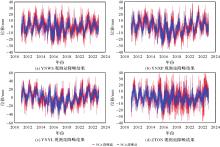
Fig. 6
PCA denoising results of some GNSS stations in Sichuan and Yunnan region"

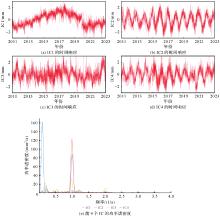
Fig. 7
Time series response and power spectrum density of the first four ICs"
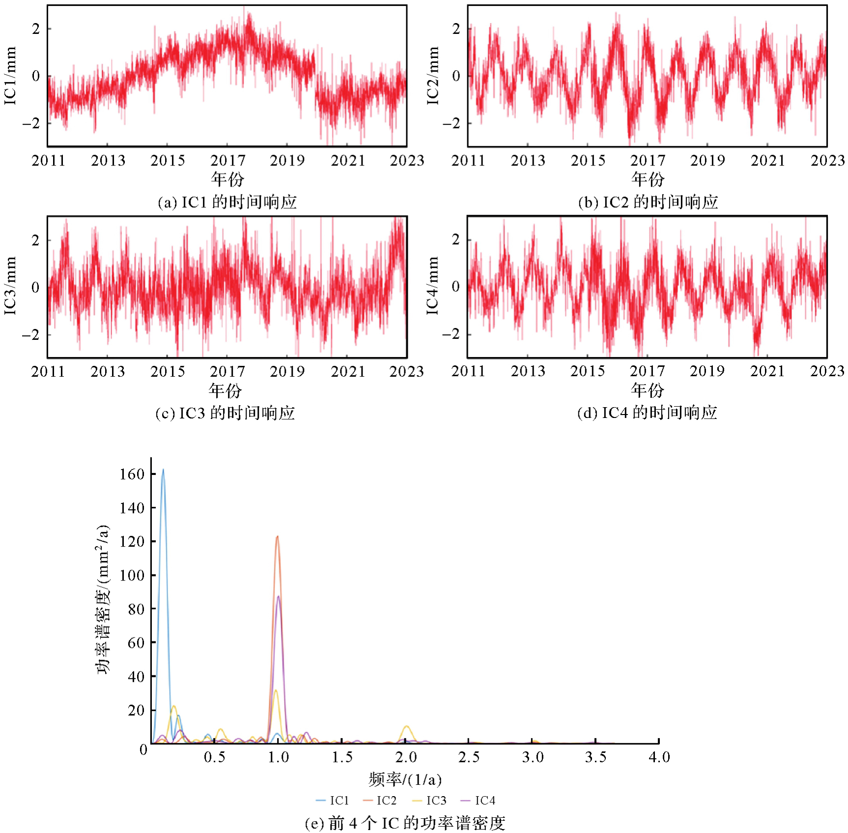
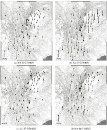
Fig. 8
Spatial responses of the first four ICs"

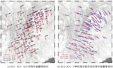
Fig. 9
Annual amplitude and phase"

Tab. 2
Correlation coefficient between IC and environmental loading deformation"
| 相关性 | 最小值 | 最大值 | 平均值 | 中位值 |
|---|---|---|---|---|
| GNSS_IC2/GRACE_HYDL | -0.18 | 0.39 | 0.23 | 0.23 |
| GNSS_IC2/IMLS_HYDL | -0.13 | 0.20 | 0.12 | 0.13 |
| GNSS_IC2/IMLS_NTAL | -0.68 | 0.71 | 0.64 | 0.67 |
| GNSS_IC2/IMLS_NTOL | -0.36 | 0.52 | 0.39 | 0.39 |
| GNSS_IC3/GRACE_HYDL | -0.55 | 0.59 | 0.06 | -0.25 |
| GNSS_IC3/IMLS_HYDL | -0.40 | 0.45 | 0.05 | -0.17 |
| GNSS_IC3/IMLS_NTAL | -0.13 | 0.18 | 0.03 | 0.02 |
| GNSS_IC3/IMLS_NTOL | -0.13 | 0.14 | 0.02 | 0.12 |
| GNSS_IC4/GRACE_HYDL | 0.55 | 0.79 | 0.69 | 0.69 |
| GNSS_IC4/IMLS_HYDL | 0.50 | 0.64 | 0.59 | 0.60 |
| GNSS_IC4/IMLS_NTAL | -0.11 | 0.26 | -0.01 | -0.04 |
| GNSS_IC4/IMLS_NTOL | -0.15 | 0.01 | -0.06 | -0.06 |
| [1] |
贺添, 孟国杰, 吴伟伟, 等. 中国地震科学实验场BDS-3定位精度和地壳运动初步分析[J]. 测绘学报, 2024, 53(4): 653-665. DOI: .
doi: 10.11947/j.AGCS.2024.20230044 |
|
HE Tian, MENG Guojie, WU Weiwei, et al. Preliminary analysis to positioning precision and crustal movement of BDS-3 data recorded by the China seismic experiment site[J]. Acta Geodaetica et Cartographica Sinica, 2024, 53(4): 653-665. DOI: .
doi: 10.11947/j.AGCS.2024.20230044 |
|
| [2] | CHEN Kejie, WEI Guoguang, MILLINER C, et al. Super-shear ruptures steered by pre-stress heterogeneities during the 2023 Kahramanmaraş earthquake doublet[J]. Nature Communications, 2024, 15: 7004. |
| [3] | ZHU Hai, CHEN Kejie, CHAI Haishan, et al. Characterizing extreme drought and wetness in Guangdong, China using global navigation satellite system and precipitation data[J]. Satellite Navigation, 2024, 5(1): 1. |
| [4] | 明锋, 杨元喜, 曾安敏, 等. 中国区域IGS站高程时间序列季节性信号及长期趋势分析[J]. 中国科学:地球科学, 2016, 46(6): 834-844, 1-3. |
| MING Feng, YANG Yuanxi, ZENG Anmin, et al. Seasonal signal and long-term trend analysis of elevation time series of IGS station in China area[J]. Scientia Sinica (Terrae), 2016, 46(6): 834-844, 1-3. | |
| [5] | 姜卫平, 王锴华, 李昭, 等. GNSS坐标时间序列分析理论与方法及展望[J]. 武汉大学学报(信息科学版), 2018, 43(12): 2112-2123. |
| JIANG Weiping, WANG Kaihua, LI Zhao, et al. Prospect and theory of GNSS coordinate time series analysis[J]. Geomatics and Information Science of Wuhan University, 2018, 43(12): 2112-2123. | |
| [6] | HEKI K, JIN Shuanggen. Geodetic study on earth surface loading with GNSS and GRACE[J]. Satellite Navigation, 2023, 4(1): 24. |
| [7] | LI Zhao, JIANG Weiping, VAN DAM T, et al. A review on modeling environmental loading effects and their contributions to nonlinear variations of global navigation satellite system coordinate time series[J]. Engineering, 2025, 47: 26-37. |
| [8] | VAN DAM T, WAHR J, MILLY P C D, et al. Crustal displacements due to continental water loading[J]. Geophysical Research Letters, 2001, 28(4): 651-654. |
| [9] | VAN DAM T, COLLILIEUX X, WUITE J, et al. Nontidal ocean loading: amplitudes and potential effects in GPS height time series[J]. Journal of Geodesy, 2012, 86(11): 1043-1057. |
| [10] | JIANG Weiping, LI Zhao, VAN DAM T, et al. Comparative analysis of different environmental loading methods and their impacts on the GPS height time series[J]. Journal of Geodesy, 2013, 87(7): 687-703. |
| [11] | DONG D, FANG P, BOCK Y, et al. Anatomy of apparent seasonal variations from GPS-derived site position time series[J]. Journal of Geophysical Research: Solid Earth, 2002, 107(B4): ETG9-1-ETG9-16. |
| [12] | HE Yuefan, NIE Guigen, WU Shuguang, et al. Comparative analysis of the correction effect of different environmental loading products on global GNSS coordinate time series[J]. Advances in Space Research, 2022, 70(11): 3594-3613. |
| [13] |
武曙光. CMONOC测站时序分析及周年相位约束聚类算法的应用研究[J]. 测绘学报, 2023, 52(9): 1614. DOI: .
doi: 10.11947/j.AGCS.2023.20220238 |
|
WU Shuguang. Study on GPS coordinate time series analysis of CMONOC stations and application of the annual phase-augmented clustering algorithm[J]. Acta Geodaetica et Cartographica Sinica, 2023, 52(9): 1614. DOI: .
doi: 10.11947/j.AGCS.2023.20220238 |
|
| [14] | FAN Wenlan, JIANG Weiping, LI Zhao, et al. Impacts of local Green's functions on modeling atmospheric loading effects for GNSS reference stations[J]. Earth and Space Science, 2024, 11(2): e2023EA003113. |
| [15] | XU Xueqing, DONG Danan, FANG Ming, et al. Contributions of thermoelastic deformation to seasonal variations in GPS station position[J]. GPS Solutions, 2017, 21(3): 1265-1274. |
| [16] | FU Yuning, ARGUS D F, FREYMUELLER J T, et al. Horizontal motion in elastic response to seasonal loading of rain water in the Amazon basin and monsoon water in Southeast Asia observed by GPS and inferred from GRACE[J]. Geophysical Research Letters, 2013, 40(23): 6048-6053. |
| [17] | 王林松, 陈超, 邹蓉, 等. 利用GPS与GRACE监测陆地水负荷导致的季节性水平形变:以喜马拉雅山地区为例[J]. 地球物理学报, 2014, 57(6): 1792-1804. |
| WANG Linsong, CHEN Chao, ZOU Rong, et al. Using GPS and GRACE to detect seasonal horizontal deformation caused by loading of terrestrial water: a case study in the Himalayas[J]. Chinese Journal of Geophysics, 2014, 57(6): 1792-1804. | |
| [18] | 胡顺强, 王坦, 管雅慧, 等. 利用GPS和水文负载模型研究云南地区垂向季节性波动变化和构造变形[J]. 地球物理学报, 2021, 64(8): 2613-2630. |
| HU Shunqiang, WANG Tan, GUAN Yahui, et al. Analyzing the seasonal fluctuation and vertical deformation in Yunnan province based on GPS measurement and hydrological loading model[J]. Chinese Journal of Geophysics, 2021, 64(8): 2613-2630. | |
| [19] | ZHAN Wei, LI Fei, HAO Weifeng, et al. Regional characteristics and influencing factors of seasonal vertical crustal motions in Yunnan, China[J]. Geophysical Journal International, 2017, 210(3): 1295-1304. |
| [20] | ZHU Hai, CHEN Kejie, HU Shunqiang, et al. Using the global navigation satellite system and precipitation data to establish the propagation characteristics of meteorological and hydrological drought in Yunnan, China[J]. Water Resources Research, 2023, 59(4): e2022WR033126. |
| [21] | HU Shunqiang, CHEN Kejie, ZHU Hai, et al. A comprehensive analysis of environmental loading effects on vertical GPS time series in Yunnan, southwest China[J]. Remote Sensing, 2022, 14(12): 2741. |
| [22] | FARRELL W E. Deformation of the Earth by surface loads[J]. Reviews of Geophysics, 1972, 10(3): 761-797. |
| [23] | MANGIAROTTI S, CAZENAVE A, SOUDARIN L, et al. Annual vertical crustal motions predicted from surface mass redistribution and observed by space geodesy[J]. Journal of Geophysical Research: Solid Earth, 2001, 106(B3): 4277-4291. |
| [24] | DILL R. Hydrological model LSDM for operational earth rotation and gravity field variations[R]. Potsdam: GFZ, 2008. |
| [25] | MARSLAND S J, HAAK H, JUNGCLAUS J H, et al. The Max-Planck-Institute global ocean/sea ice model with orthogonal curvilinear coordinates[J]. Ocean Modelling, 2003, 5(2): 91-127. |
| [26] | GELARO R, MCCARTY W, SUÁREZ M J, et al. The modern-era retrospective analysis for research and applications, version 2 (MERRA-2)[J]. Journal of Climate, 2017, 30(13): 5419-5454. |
| [27] | DOBSLAW H, THOMAS M. Simulation and observation of global ocean mass anomalies[J]. Journal of Geophysical Research: Oceans, 2007, 112(C5): 1-11. |
| [28] | MING Feng, YANG Yuanxi, ZENG Anmin, et al. Spatiotemporal filtering for regional GPS network in China using independent component analysis[J]. Journal of Geodesy, 2017, 91(4): 419-440. |
| [29] | LIU Bin, DAI Wujiao, LIU Ning. Extracting seasonal deformations of the Nepal Himalaya region from vertical GPS position time series using independent component analysis[J]. Advances in Space Research, 2017, 60(12): 2910-2917. |
| [30] | GU Y, YUAN L, FAN D, et al. Seasonal crustal vertical deformation induced by environmental mass loading in mainland China derived from GPS, GRACE and surface loading models[J]. Advances in Space Research, 2017, 59(1): 88-102. |
| [31] | 闫昊明, 陈武, 朱耀仲, 等. 温度变化对我国GPS台站垂直位移的影响[J]. 地球物理学报, 2010, 53(4): 825-832. |
| YAN Haoming, CHEN Wu, ZHU Yaozhong, et al. Thermal effects on vertical displacement of GPS stations in China[J]. Chinese Journal of Geophysics, 2010, 53(4): 825-832. | |
| [32] | TAN Weijie, DONG Danan, CHEN Junping. Application of independent component analysis to GPS position time series in Yunnan province, southwest of China[J]. Advances in Space Research, 2022, 69(11): 4111-4122. |
| [33] | HU Shunqiang, CHEN Kejie, ZHU Hai, et al. Potential contributors to CME and optimal noise model analysis in the Chinese region based on different HYDL models[J]. Remote Sensing, 2023, 15(4): 945. |
| [34] | BARNIE T, OPPENHEIMER C. Extracting high temperature event radiance from satellite images and correcting for saturation using independent component analysis[J]. Remote Sensing of Environment, 2015, 158: 56-68. |
| [35] | PAN Yuanjin, JIANG Weiping, DING Hao, et al. Intradecadal fluctuations and three-dimensional crustal kinematic deformation of the Tianshan and Pamir derived from multi-geodetic imaging[J]. Journal of Geophysical Research: Solid Earth, 2023, 128(1): e2022JB025325. |
| [36] | YI Shuang, SNEEUW N. Filling the data gaps within GRACE missions using singular spectrum analysis[J]. Journal of Geophysical Research: Solid Earth, 2021, 126(5): e2020JB021227. |
| [1] | Yi GAO, Xin LIU, Daocheng YU, Shaoshuai YA, Shaofeng BIAN, Heping SUN, Jinyun GUO. An automated seamount detection method integrating vertical gravity gradient anomaly and seafloor topographic models [J]. Acta Geodaetica et Cartographica Sinica, 2026, 55(4): 647-657. |
| [2] | Jinwei BU, Shuhui LIU, Shunshuang XU, Tongsu XIANG, Qiulan WANG, Chaoying JI, Xiaoqing ZUO. Construction of an empirical model for estimating the global wave period of spaceborne GNSS-R [J]. Acta Geodaetica et Cartographica Sinica, 2026, 55(4): 684-697. |
| [3] | Min YANG, Hongran MA, Bo KONG, Pengcheng LIU, Tinghua AI. A pre-trained model-based method for discriminating morphological patterns of vector-based coastlines [J]. Acta Geodaetica et Cartographica Sinica, 2026, 55(3): 404-414. |
| [4] | Tangting WU, Xinyu LUO, Liguo LU, Zhanke LIU, Nengfang CHAO. Assessment of water resource changes and drought characteristics in the Shaanxi, Gansu and Ningxia region based on GNSS and GRACE/GRACE-FO [J]. Acta Geodaetica et Cartographica Sinica, 2026, 55(3): 439-450. |
| [5] | Zhongmin MA, Shuangcheng ZHANG, Xin ZHOU, Qi LIU, Ning LIU, Hengli WANG. A flood monitoring method using FY-3 GNSS-R accounting for surface reflectivity uncertainty: a case study of the August 2 Guangdong rainstorm disaster [J]. Acta Geodaetica et Cartographica Sinica, 2026, 55(3): 451-464. |
| [6] | Zejiao WANG, Longgang XIANG, Meng WANG, Xingjuan WANG, Qing LIU. Hierarchical feature and diversified attention fusion network for collaborative extraction of road surface and centerline [J]. Acta Geodaetica et Cartographica Sinica, 2026, 55(3): 548-563. |
| [7] | Zhong LU, Jinqi ZHAO, Yufen NIU, Liquan CHEN, Qianyou FAN, Jinzhao SI, Zixuan WANG, Yuan GAO, Shuai WANG, Feifei QU, Hongtao SHI, Shiyong YAN, Yun SHI, Zheng ZHAO. The NISAR mission: innovations in earth observation and applications in surface deformation monitoring [J]. Acta Geodaetica et Cartographica Sinica, 2026, 55(2): 261-274. |
| [8] | Qingyun YAN, Zixuan GUO, Yuanjin PAN, Yan JIA, Shuanggen JIN. Quantitative driving factors and zoning patterns of GNSS-R land surface reflectivity spatial heterogeneity [J]. Acta Geodaetica et Cartographica Sinica, 2026, 55(2): 315-327. |
| [9] | Qingzhi ZHAO, Duoduo JIANG, Yibin YAO, Zhi MA, Yongjie MA, Haojie LI, Ruirui XUE. An adaptive method for selecting the optimal GNSS satellite signal for water vapor tomography [J]. Acta Geodaetica et Cartographica Sinica, 2026, 55(1): 25-35. |
| [10] | Zhibin XING, Shanshan LI, Miao TIAN, Yao MENG, Na YANG, Qian LI, Pinyao CHANG. FFT block-diagonal least square method for constructing spherical harmonic model of earth topography with degree 10 800 [J]. Acta Geodaetica et Cartographica Sinica, 2026, 55(1): 36-45. |
| [11] | Deying YU, Houpu LI, Yi LIU, Shuguang WU, Deyan LI, Mingchao LI, Wenkui LI, Shaofeng BIAN. A DBSCAN-based RAIM algorithm for multiple gross error identification [J]. Acta Geodaetica et Cartographica Sinica, 2026, 55(1): 59-72. |
| [12] | Dongliang CHENG, Lingqiu CHEN, Zhiyong HUANG, Shubo QIAO, Dandan WANG, Yaming YAN. Performance evaluation of COATS-based multi-mode and multi-frequency iGNSS-R altimetry [J]. Acta Geodaetica et Cartographica Sinica, 2026, 55(1): 73-89. |
| [13] | Pengcheng LIU, Xiaoqiang CHENG, Tianyuan XIAO, Min YANG, Tinghua AI. A Transformer model for building polygon simplification in map generalization [J]. Acta Geodaetica et Cartographica Sinica, 2026, 55(1): 124-137. |
| [14] | Chuanyin ZHANG, Tao JIANG, Baogui KE. Theoretical foundation of gravity field and improvement of classical concepts for geodetic height datum unified in the terrestrial reference system [J]. Acta Geodaetica et Cartographica Sinica, 2025, 54(9): 1561-1571. |
| [15] | Zhen LI, Zhenghang HE, Chuang SHI. A high-degree gravitational potential and gradient calculation method without singularities [J]. Acta Geodaetica et Cartographica Sinica, 2025, 54(9): 1572-1582. |
| Viewed | ||||||
|
Full text |
|
|||||
|
Abstract |
|
|||||