

Acta Geodaetica et Cartographica Sinica ›› 2025, Vol. 54 ›› Issue (7): 1192-1205.doi: 10.11947/j.AGCS.2025.20250119
• Geodesy and Navigation • Previous Articles Next Articles
Qingzhi ZHAO1( ), Lulu CHANG1, Yibin YAO2(), Haojie LI1
Received:2025-03-17
Revised:2025-06-20
Online:2025-08-18
Published:2025-08-18
Contact:
Yibin YAO
E-mail:zhaoqingzhia@163.com;ybyao@whu.edu.cn
About author:ZHAO Qingzhi (1989—), male, PhD, professor, majors in GNSS data processing and GNSS meteorology. E-mail: zhaoqingzhia@163.com
Supported by:CLC Number:
Qingzhi ZHAO, Lulu CHANG, Yibin YAO, Haojie LI. A method for constructing a hydrological drought index integrated with GNSS and meteorological data[J]. Acta Geodaetica et Cartographica Sinica, 2025, 54(7): 1192-1205.
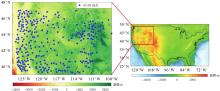
Fig. 1
Geographical location of the northwestern native United States and the spatial distribution map of 302 GNSS stations"

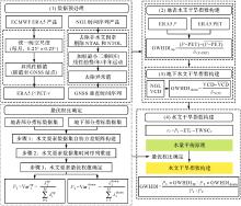
Fig. 2
Construction flowchart of the GWHDI method"

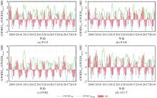
Fig. 3
Long-term time series comparison of different hydrological drought monitoring indices and SRI at 4 GNSS stations over the period of 2009 to 2018"

Tab. 1
Accuracy comparison of different hydrological drought monitoring indices and SRI at 4 GNSS stations over the period of 2006 to 2020"
| 站点 | R2 | RMS | MAE | |||
|---|---|---|---|---|---|---|
| 地表水文干旱指标 | 地下水文干旱指标 | 地表水文干旱指标 | 地下水文干旱指标 | 地表水文干旱指标 | 地下水文干旱指标 | |
| P113 | 0.67 | 0.36 | 0.79 | 1.58 | 0.68 | 1.32 |
| P100 | 0.69 | 0.43 | 0.77 | 1.64 | 0.63 | 1.35 |
| P682 | 0.61 | 0.54 | 0.87 | 1.71 | 0.72 | 1.39 |
| ALUT | 0.70 | 0.52 | 0.75 | 1.68 | 0.62 | 1.40 |
| 平均值 | 0.67 | 0.46 | 0.80 | 1.65 | 0.66 | 1.37 |
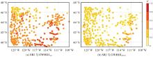
Fig. 4
Spatial distribution of the correlation between SRI and different hydrological drought monitoring indices at 302 GNSS stations over the period of 2006 to 2020"
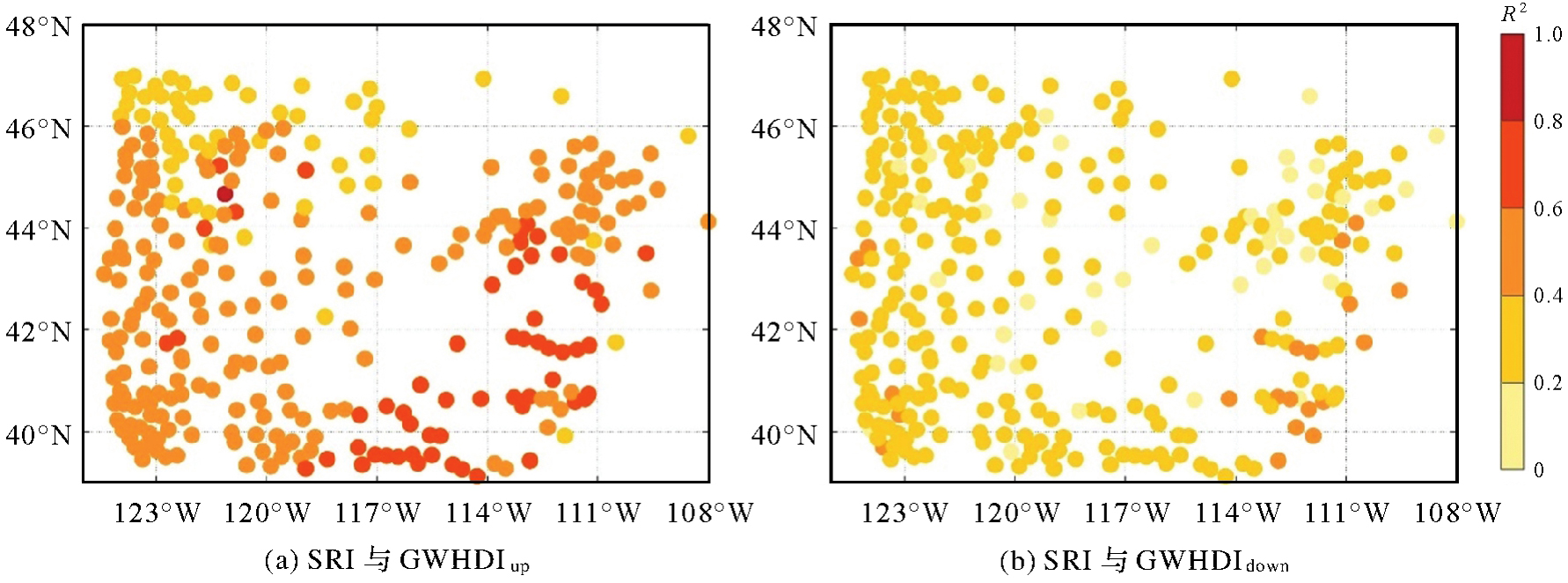
Fig. 5
Weight spatial distribution of different hydrological elements"
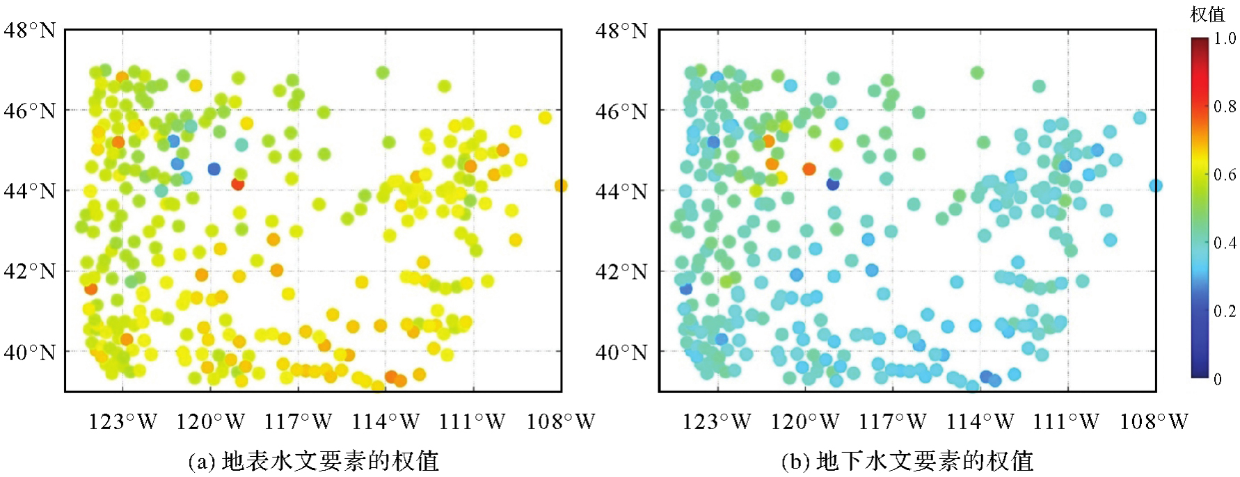
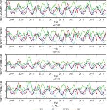
Fig. 6
Long-term time series comparison of HDI, DSI, GWHDI and SRI at 4 GNSS sites over the period of 2009 to 2018"

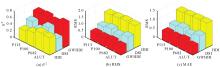
Fig. 7
The 3D bar comparing R2, RMS and MAE of HDI, DSI and GWHDI with SRI at 4 GNSS stations"

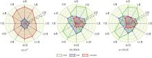
Fig. 8
The radar chart of R2, RMS and MAE from HDI, DSI and GWHDI in different months at 302 GNSS stations over the period of 2006 to 2020"

Tab. 2
Seasonal accuracy of HDI, DSI and GWHDI at 302 GNSS stations over the period of 2006 to 2020"
| 季节 | R2 | RMS | MAE | ||||||
|---|---|---|---|---|---|---|---|---|---|
| HDI | DSI | GWHDI | HDI | DSI | GWHDI | HDI | DSI | GWHDI | |
| 春 | 0.21 | 0.21 | 0.83 | 1.90 | 1.11 | 0.96 | 1.65 | 0.92 | 0.82 |
| 夏 | 0.20 | 0.21 | 0.62 | 1.36 | 1.12 | 0.50 | 1.17 | 0.94 | 0.39 |
| 秋 | 0.22 | 0.26 | 0.77 | 1.51 | 1.22 | 0.75 | 1.31 | 0.98 | 0.65 |
| 冬 | 0.20 | 0.22 | 0.63 | 1.32 | 1.22 | 1.01 | 1.10 | 1.00 | 0.85 |
| 平均值 | 0.21 | 0.23 | 0.71 | 1.52 | 1.17 | 0.81 | 1.31 | 0.96 | 0.68 |
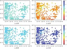
Fig. 9
Spatial distribution of GWHDI at 302 GNSS sites in different seasons over the period of 2006 to 2020"

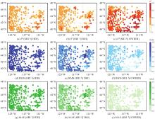
Fig. 10
Spatial distribution of R2, RMS and MAE from HDI, DSI and GWHDI at 302 GNSS stations over the period of 2006 to 2020 with SRI as the reference"

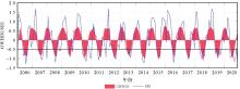
Fig. 11
Long-term comparison of GWHDI and SRI over the period of 2006 to 2020"

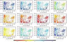
Fig. 12
Spatial distribution of GWHDI from January to December 2013"

| [1] | 许怡然, 鲁帆, 谢子波, 等. 潮白河流域气象水文干旱特征及其响应关系[J]. 干旱地区农业研究, 2019, 37(2): 220-228. |
| XU Yiran, LU Fan, XIE Zibo, et al. Characteristics and responses of hydrological and meteorological drought in Chaobai River basin[J]. Agricultural Research in the Arid Areas, 2019, 37(2): 220-228. | |
| [2] | KADAPALA B K R, ASHA FARSANA M, GEETHA VIMALA C H, et al. A grid-wise approach for accurate computation of standardized runoff index (SRI)[J]. Science of the Total Environment, 2024, 946: 174472. |
| [3] | ZHAO Qingzhi, LIU Kang, SUN Tingting, et al. A novel regional drought monitoring method using GNSS-derived ZTD and precipitation[J]. Remote Sensing of Environment, 2023, 297: 113778. |
| [4] | SHUKLA S, WOOD A W. Use of a standardized runoff index for characterizing hydrologic drought[J]. Geophysical Research Letters, 2008, 35(2): L02405. |
| [5] | NALBANTIS I, TSAKIRIS G. Assessment of hydrological drought revisited[J]. Water Resources Management, 2009, 23(5): 881-897. |
| [6] | GUTTMAN N B. A sensitivity analysis of the palmer hydrologic drought index[J]. JAWRA Journal of the American Water Resources Association, 1991, 27(5): 797-807. |
| [7] | SHAFER B, DEZMAN L. Development of a surface water supply index (SWSI) to assess the severity of drought conditions in snowpack runoff areas[C]//Proceedings of 1982 Annual Western Snow Conference. Fort Collins: [s.n.], 1982: 164-175. |
| [8] | ANDERSON E S, SCHILLING K E. Expanding the applications of the standardized streamflow index through regionalization[J]. Journal of the American Water Resources Association, 2024, 60(4): 837-850. |
| [9] | 粟晓玲, 张更喜, 冯凯. 干旱指数研究进展与展望[J]. 水利与建筑工程学报, 2019, 17(5): 9-18. |
| SU Xiaoling, ZHANG Gengxi, FENG Kai. Progress and perspective of drought index[J]. Journal of Water Resources and Architectural Engineering, 2019, 17(5): 9-18. | |
| [10] | HAO Zengchao, AGHAKOUCHAK A. A nonparametric multivariate multi-index drought monitoring framework[J]. Journal of Hyd-rometeorology, 2014, 15(1): 89-101. |
| [11] | FENG Keting, CAO Yanping, DU Erji, et al. Spatiotemporal dynamics of drought and the ecohydrological response in central Asia[J]. Remote Sensing, 2025, 17(1): 166. |
| [12] | 栾奎峰, 薛家盛, 冯贵平, 等. 基于GRACE/GRACE-FO的黄河流域水储量及干旱特征研究[J]. 干旱区研究, 2025, 42(2): 246-257. |
| LUAN Kuifeng, XUE Jiasheng, FENG Guiping, et al. Drought characteristics of terrestrial water storage in the Yellow River basin based on GRACE/GRACE-FO[J]. Arid Zone Research, 2025, 42(2): 246-257. | |
| [13] | ZHAO Meng, GERUO A, VELICOGNA I, et al. A global gridded dataset of GRACE drought severity index for 2002-14: comparison with PDSI and SPEI and a case study of the Australia millennium drought[J]. Journal of Hydrometeorology, 2017, 18(8): 2117-2129. |
| [14] | LIU Xiaojun, WANG Naiang, WANG Yixin, et al. Research on groundwater drought and sustainability in badain jaran desert and surrounding areas based on GRACE satellite[J]. Land, 2025, 14(1): 173. |
| [15] | REN Jintao, XU Min, KANG Shichang, et al. Comprehensive understanding of hydrological drought based on GRACE data at multiple spatiotemporal scales in Northwest China[J]. Natural Hazards, 2025, 121(3): 2465-2481. |
| [16] | HU Fengmin, YANG Beibei, WEI Zushuai, et al. Filling the data gap between GRACE and GRACE-FO based on a two-step reconstruction method[J]. International Journal of Digital Earth, 2025, 18(1): 2468418. |
| [17] | YAO Chaolong, SHUM C K, LUO Zhicai, et al. An optimized hydrological drought index integrating GNSS displacement and satellite gravimetry data[J]. Journal of Hydrology, 2022, 614: 128647. |
| [18] | ZHANG Xu, LI Jinbao, WANG Zifeng, et al. Global hydroclimatic drivers of terrestrial water storage changes in different climates[J]. Catena, 2022, 219: 106598. |
| [19] | TANG Miao, YUAN Linguo, JIANG Zhongshan, et al. Characterization of hydrological droughts in Brazil using a novel multiscale index from GNSS[J]. Journal of Hydrology, 2023, 617: 128934. |
| [20] | JIANG Zhongshan, HSU Y J, YUAN Linguo, et al. Insights into hydrological drought characteristics using GNSS-inferred large-scale terrestrial water storage deficits[J]. Earth and Planetary Science Letters, 2022, 578: 117294. |
| [21] | JIANG Zhongshan, HSU Y J, YUAN Linguo, et al. Characterizing spatiotemporal patterns of terrestrial water storage variations using GNSS vertical data in Sichuan, China[J]. Journal of Geophysical Research: Solid Earth, 2021, 126(12): e2021JB022398. |
| [22] |
瞿伟, 晋泽辉, 张勤, 等. GRACE与GRACE Follow-On重力卫星数据揭示出的黄河流域2002—2020年干旱特征[J]. 测绘学报, 2023, 52(5): 714-724. DOI: .
doi: 10.11947/j.AGCS.2023.20210458 |
|
QU Wei, JIN Zehui, ZHANG Qin, et al. Drought characteristics of the Yellow River basin from 2002 to 2020 revealed by GRACE and GRACE follow-on data[J]. Acta Geodaetica et Cartographica Sinica, 2023, 52(5): 714-724. DOI: .
doi: 10.11947/j.AGCS.2023.20210458 |
|
| [23] |
姚朝龙, 陈涌鑫, 罗志才, 等. GNSS/GRACE/GRACE-FO/气象数据结合反演干旱指数[J]. 测绘学报, 2023, 52(11): 1883-1891. DOI: .
doi: 10.11947/j.AGCS.2023.20220484 |
|
YAO Chaolong, CHEN Yongxin, LUO Zhicai, et al. A drought index derived from a combination of GNSS GRACE/GRACE-FO and meteorological data[J]. Acta Geodaetica et Cartographica Sinica, 2023, 52(11): 1883-1891. DOI: .
doi: 10.11947/j.AGCS.2023.20220484 |
|
| [24] | PENG Yujie, CHEN Gang, CHAO Nengfang, et al. Detection of extreme hydrological droughts in the Poyang lake basin during 2021—2022 using GNSS-derived daily terrestrial water storage anomalies[J]. Science of the Total Environment, 2024, 919: 170875. |
| [25] | XIONG Jinghua, GUO Shenglian, ABHISHEK , et al. A novel standardized drought and flood potential index based on reconstructed daily GRACE data[J]. Journal of Hydrometeorology, 2022, 23(9): 1419-1438. |
| [26] | 庞亚瑾, 张怀, 程惠红, 等. 华北地区地下水开采对地壳应力的影响[J]. 地球物理学报, 2016, 59(4): 1394-1402. |
| PANG Yajin, ZHANG Huai, CHENG Huihong, et al. Changes of crustal stress induced by groundwater over-pumping in North China Plain[J]. Chinese Journal of Geophysics, 2016, 59(4): 1394-1402. | |
| [27] | 李莎, 朱春瑞, 惠雪飘, 等. 贵州省水文干旱演变趋势及特征分析[J/OL]. 人民珠江. [2024-12-13]. https://link.cnki.net/urlid/44.1037.TV.20250210.1626.014. |
| LI Sha, ZHU Chunrui, HUI Xuepiao, et al. Analysis of the evolutionary trends and characteristics of hydrological drought in Guizhou province[J/OL]. People's Pearl River. [2024-12-13]. https://link.cnki.net/urlid/44.1037.TV.20250210.1626.014. | |
| [28] | ZHAO Qingzhi, LIU Kang, LI Zufeng, et al. A novel ENSO monitoring index and its potential for drought application[J]. Journal of Atmospheric and Solar-Terrestrial Physics, 2021, 225: 105762. |
| [29] | ZHAO Qingzhi, LIU Yang, YAO Wanqiang, et al. A novel ENSO monitoring method using precipitable water vapor and temperature in southeast China[J]. Remote Sensing, 2020, 12(4): 649. |
| [30] | ZHANG Bao, LIU Lin, KHAN S A, et al. Transient variations in glacial mass near Upernavik Isstrøm (west Greenland) detected by the combined use of GPS and GRACE data[J]. Journal of Geophysical Research: Solid Earth, 2017, 122(12): 10626-10642. |
| [31] | GHIL M, VAUTARD R. Interdecadal oscillations and the warming trend in global temperature time series[J]. Nature, 1991, 350(6316): 324-327. |
| [1] | Jinwei BU, Shuhui LIU, Shunshuang XU, Tongsu XIANG, Qiulan WANG, Chaoying JI, Xiaoqing ZUO. Construction of an empirical model for estimating the global wave period of spaceborne GNSS-R [J]. Acta Geodaetica et Cartographica Sinica, 2026, 55(4): 684-697. |
| [2] | Tangting WU, Xinyu LUO, Liguo LU, Zhanke LIU, Nengfang CHAO. Assessment of water resource changes and drought characteristics in the Shaanxi, Gansu and Ningxia region based on GNSS and GRACE/GRACE-FO [J]. Acta Geodaetica et Cartographica Sinica, 2026, 55(3): 439-450. |
| [3] | Zhongmin MA, Shuangcheng ZHANG, Xin ZHOU, Qi LIU, Ning LIU, Hengli WANG. A flood monitoring method using FY-3 GNSS-R accounting for surface reflectivity uncertainty: a case study of the August 2 Guangdong rainstorm disaster [J]. Acta Geodaetica et Cartographica Sinica, 2026, 55(3): 451-464. |
| [4] | Qingyun YAN, Zixuan GUO, Yuanjin PAN, Yan JIA, Shuanggen JIN. Quantitative driving factors and zoning patterns of GNSS-R land surface reflectivity spatial heterogeneity [J]. Acta Geodaetica et Cartographica Sinica, 2026, 55(2): 315-327. |
| [5] | Qingzhi ZHAO, Duoduo JIANG, Yibin YAO, Zhi MA, Yongjie MA, Haojie LI, Ruirui XUE. An adaptive method for selecting the optimal GNSS satellite signal for water vapor tomography [J]. Acta Geodaetica et Cartographica Sinica, 2026, 55(1): 25-35. |
| [6] | Deying YU, Houpu LI, Yi LIU, Shuguang WU, Deyan LI, Mingchao LI, Wenkui LI, Shaofeng BIAN. A DBSCAN-based RAIM algorithm for multiple gross error identification [J]. Acta Geodaetica et Cartographica Sinica, 2026, 55(1): 59-72. |
| [7] | Dongliang CHENG, Lingqiu CHEN, Zhiyong HUANG, Shubo QIAO, Dandan WANG, Yaming YAN. Performance evaluation of COATS-based multi-mode and multi-frequency iGNSS-R altimetry [J]. Acta Geodaetica et Cartographica Sinica, 2026, 55(1): 73-89. |
| [8] | Yarong LUO, Wentao LU, Chi GUO, Jingnan LIU. Left-handed symmetry equivariant filtering model and algorithm for GNSS/INS integrated navigation [J]. Acta Geodaetica et Cartographica Sinica, 2025, 54(8): 1389-1403. |
| [9] | Yangyi CHEN, Kai ZHENG, Xiaohong ZHANG, Mingkui WU, Pengxu WANG, Wenju FU, Kezhong LIU. GPS/Galileo/BDS overlapping frequencies multipath error analysis and modeling [J]. Acta Geodaetica et Cartographica Sinica, 2025, 54(8): 1427-1438. |
| [10] | Jianzhang LI, Haowen YAN, Weifang YANG, Xiaoning SU. GNSS pseudo trigonometric leveling method [J]. Acta Geodaetica et Cartographica Sinica, 2025, 54(7): 1170-1177. |
| [11] | Qianxin WANG, Chao HU, Tong CHENG. A method for satellite ultra-rapid orbit and clock offset estimation based on the prior information of the GNSS clock parameters [J]. Acta Geodaetica et Cartographica Sinica, 2025, 54(6): 982-994. |
| [12] | Yang SHEN, Guangyun LI, Mingjian CHEN, Linyang LI, Xingyu SHI, Wei CAI, Weifeng HAO. Assessment of GNSS ionosphere models based on FY-3 TEC in polar regions [J]. Acta Geodaetica et Cartographica Sinica, 2025, 54(6): 995-1008. |
| [13] | Shunqiang HU, Kejie CHEN, Xiaoxing HE, Hai ZHU, Tan WANG. The impact of environmental loading on nonlinear variations of 3D coordinate time series of GNSS stations in Sichuan and Yunnan region [J]. Acta Geodaetica et Cartographica Sinica, 2025, 54(5): 805-818. |
| [14] | Wentao YANG, Fei GUO, Xiaohong ZHANG, Zhiyu ZHANG, Yifan ZHU, Zheng LI, Ziheng WU. Soil moisture and freeze-thaw map using GNSS reflectometer and SMAP radiometer for Qinghai-Xizang Plateau [J]. Acta Geodaetica et Cartographica Sinica, 2025, 54(4): 725-735. |
| [15] | Qingzhi ZHAO, Duoduo JIANG, Hongwu GUO, Zufeng LI, Chen LIU, Yibin YAO. A general method for determining the key parameters of GNSS water vapor tomography modeling [J]. Acta Geodaetica et Cartographica Sinica, 2025, 54(3): 410-421. |
| Viewed | ||||||
|
Full text |
|
|||||
|
Abstract |
|
|||||