

Acta Geodaetica et Cartographica Sinica ›› 2025, Vol. 54 ›› Issue (11): 1968-1979.doi: 10.11947/j.AGCS.2025.20250231
• Geodesy and Navigation • Previous Articles Next Articles
Yuanyuan GU1,2( ), Xu YAO3, Lu AN1,2(), Gang QIAO1,2, Tong HAO1,2
Received:2025-06-05
Revised:2025-11-03
Online:2025-12-15
Published:2025-12-15
Contact:
Lu AN
E-mail:yuan1@tongji.edu.cn;anlu2021@tongji.edu.cn
About author:GU Yuanyuan (1996—), male, PhD candidate, majors in GNSS data processing as well as the validation and application of satellite laser altimetry data. E-mail: yuan1@tongji.edu.cn
Supported by:CLC Number:
Yuanyuan GU, Xu YAO, Lu AN, Gang QIAO, Tong HAO. Analysis and evaluation of route roughness along the CHINARE inland traverse based on high-precision dynamic GNSS data[J]. Acta Geodaetica et Cartographica Sinica, 2025, 54(11): 1968-1979.
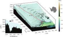
Fig. 1
3D terrain along the route of China's 39th Antarctic inland expedition"
Tab. 1
Statistics of working hours at reference stations"
| 基准站 | 观测天数/d |
|---|---|
| Base1 | 7 |
| Base2 | 4 |
| Base3 | 5 |
| Base4 | 5 |
| Base5 | 4 |
| Base6 | 5 |
| Base7 | 4 |
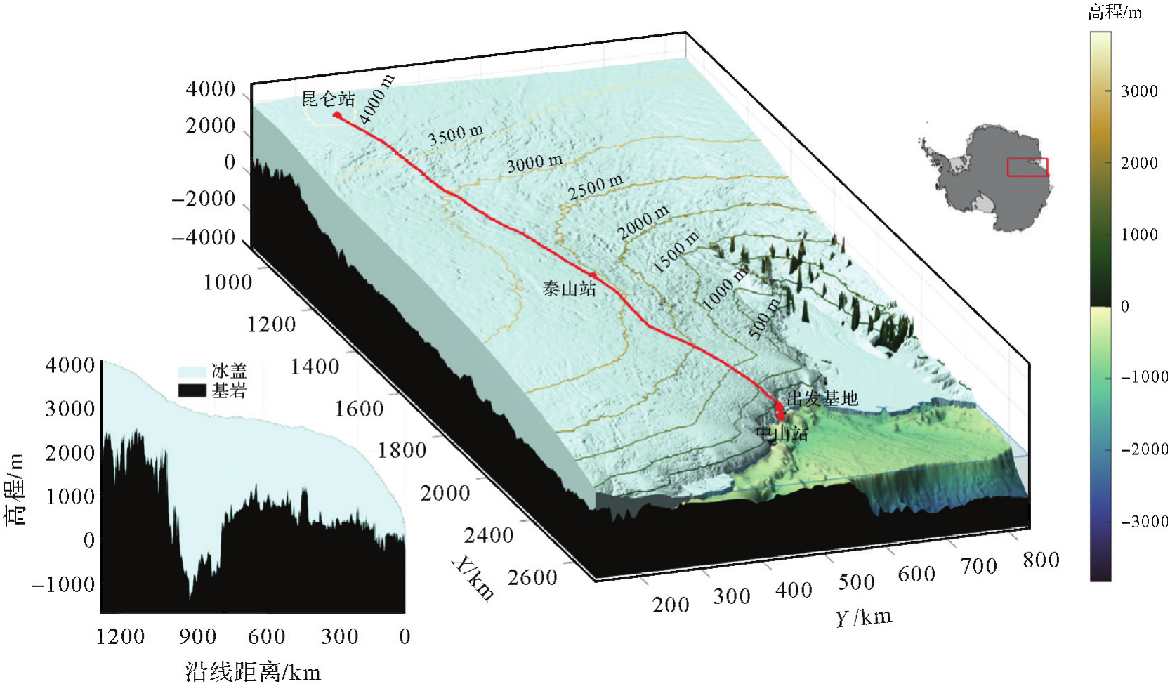
Fig. 2
Distribution of GNSS mobile stations and 7 reference stations along the route"

Fig. 3
The characteristics of different terrain roughness along the CHINARE route"

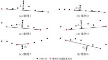
Fig. 4
Extracting vertical displacement d1-d6 under different terrain feature conditions"
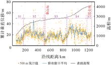
Fig. 5
Distribution of cumulative vertical displacement along the snowmobile traverse"

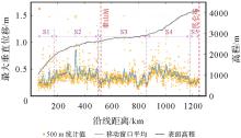
Fig. 6
Distribution of maximum vertical displacement along the snowmobile traverse"

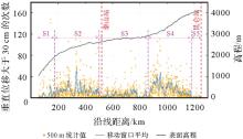
Fig. 7
Frequency of vertical displacements exceeding 30 cm along the snowmobile traverse"
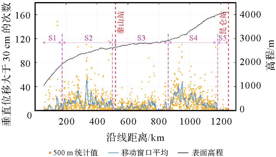
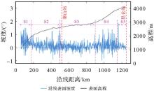
Fig. 8
Surface slope and elevation along the route"

Tab. 2
Statistical indicators for different segments along the route"
| 路段(距离范围) | 垂直位移/(m/km) | 最大垂直位移/m | 超过30 cm发生频率/(次/km) | 平均坡度/(°) |
|---|---|---|---|---|
| S1(55~175 km) | 12.26 | 0.29 | 4.92 | 0.42 |
| S2(175~500 km) | 23.00 | 0.42 | 14.34 | 0.11 |
| S3(500~860 km) | 16.11 | 0.32 | 5.29 | 0.07 |
| S4(860~1180 km) | 25.40 | 0.41 | 16.35 | 0.21 |
| S5(1180~1250 km) | 17.58 | 0.26 | 0.55 | 0.07 |
| 全程平均 | 20.21 | 0.37 | 10.45 | 0.15 |
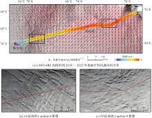
Fig. 9
Distribution of mean surface wind speed and direction along the CHINARE inland route from 2018 to 2022, with Landsat-8 imagery in the S2 and S4 sections"

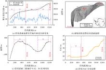
Fig. 10
Surface flatness, 3D terrain, wind direction, and FAC distributions along the CHINARE inland route"

| [1] | RIGNOT E, MOUGINOT J, SCHEUCHL B, et al. Four decades of Antarctic ice sheet mass balance from 1979—2017[J]. Proceedings of the National Academy of Sciences, 2019, 116(4): 1095-1103. |
| [2] | SHEPHERD A, IVINS E, RIGNOT E, et al. Mass balance of the Greenland ice sheet from 1992 to 2018[J]. Nature, 2019, 579(7798): 233-239. |
| [3] | CHRISTNER B C, PRISCU J C, ACHBERGER A M, et al. A microbial ecosystem beneath the West Antarctic ice sheet[J]. Nature, 2014, 512(7514): 310-313. |
| [4] | SIEGERT M J, PRISCU J C, ALEKHINA I A, et al. Antarctic subglacial lake exploration: first results and future plans[J]. Philosophical Transactions of the Royal Society A: Mathematical, Physical and Engineering Sciences, 2016, 374(2059): 20140466. |
| [5] | RIGNOT E, MOUGINOT J, SCHEUCHL B. Ice flow of the Antarctic ice sheet[J]. Science, 2011, 333(6048): 1427-1430. |
| [6] | CSATHO B M, SCHENK A F, VAN DER VEEN C J, et al. Laser altimetry reveals complex pattern of Greenland ice sheet dynamics[J]. Proceedings of the National Academy of Sciences, 2014, 111(52): 18478-18483. |
| [7] | TIAN Biao, DING Minghu, PUTERO D, et al. Multi-year variation of near-surface ozone at Zhongshan station, Antarctica[J]. Environmental Research Letters, 2022, 17(4): 044003. |
| [8] | DING Minghu, ZOU Xiaowei, SUN Qizhen, et al. The PANDA automatic weather station network between the coast and Dome A, East Antarctica[J]. Earth System Science Data, 2022, 14(11): 5019-5035. |
| [9] | MA Bin, SHANG Zhaohui, HU Yi, et al. Night-time measurements of astronomical seeing at Dome A in Antarctica[J]. Nature, 2020, 583(7818): 771-774. |
| [10] | MA Bin, HU Yi, SHANG Zhaohui, et al. Automation of the AST3 optical sky survey from Dome A, Antarctica[J]. Monthly Notices of the Royal Astronomical Society, 2020, 496(3): 2768-2775. |
| [11] | DONG Sheng, FU Lei, TANG Xueyuan, et al. Deep clustering in subglacial radar reflectance reveals subglacial lakes[J]. The Cryosphere, 2024, 18(3): 1241-1257. |
| [12] | DING Minghu, XIAO Cunde, LI Chuanjin, et al. Surface mass balance and its climate significance from the coast to Dome A, East Antarctica[J]. Science China Earth Sciences, 2015, 58(10): 1787-1797. |
| [13] | BRUNT K M, NEUMANN T A, SMITH B E. Assessment of ICESat-2 ice sheet surface heights, based on comparisons over the interior of the Antarctic ice sheet[J]. Geophysical Research Letters, 2019, 46(22): 13072-13078. |
| [14] | BRUNT K M, SMITH B E, SUTTERLEY T C, et al. Comparisons of satellite and airborne altimetry with ground-based data from the interior of the Antarctic ice sheet[J]. Geophysical Research Letters, 2021, 48(2): e2020GL090572. |
| [15] | BRUNT K M, NEUMANN T A, LARSEN C F. Assessment of altimetry using ground-based GPS data from the 88S Traverse, Antarctica, in support of ICESat-2[J]. The Cryosphere, 2019, 13(2): 579-590. |
| [16] | SCHRÖDER L, RICHTER A, FEDOROV D V, et al. Validation of satellite altimetry by kinematic GNSS in central East Antarctica[J]. The Cryosphere, 2017, 11(3): 1111-1130. |
| [17] | KOHLER J, NEUMANN T A, ROBBINS J W, et al. ICESat elevations in Antarctica along the 2007-09 Norway-USA traverse: validation with ground-based GPS[J]. IEEE Transactions on Geoscience and Remote Sensing, 2013, 51(3): 1578-1587. |
| [18] | LI Rongxing, LI Hongwei, HAO Tong, et al. Assessment of ICESat-2 ice surface elevations over the Chinese Antarctic research expedition (CHINARE) route, East Antarctica, based on coordinated multi-sensor observations[J]. The Cryosphere, 2021, 15(7): 3083-3099. |
| [19] | HOWAT I M, PORTER C, SMITH B E, et al. The reference elevation model of Antarctica[J]. The Cryosphere, 2019, 13(2): 665-674. |
| [20] | MARKUS T, NEUMANN T, MARTINO A, et al. The ice, cloud, and land elevation satellite-2 (ICESat-2): science requirements, concept, and implementation[J]. Remote Sensing of Environment, 2017, 190: 260-273. |
| [21] | MORLIGHEM M, WILLIAMS C N, RIGNOT E, et al. BedMachine v3: complete bed topography and ocean bathymetry mapping of Greenland from multibeam echo sounding combined with mass conservation[J]. Geophysical Research Letters, 2017, 44(21): 11051-11061. |
| [22] | MORLIGHEM M, RIGNOT E, BINDER T, et al. Deep glacial troughs and stabilizing ridges unveiled beneath the margins of the Antarctic ice sheet[J]. Nature Geoscience, 2019, 13(2): 132-137. |
| [23] | GREENE C A, GWYTHER D E, BLANKENSHIP D D. Antarctic mapping tools for Matlab[J]. Computers & Geosciences, 2017, 104: 151-157. |
| [24] | BINDSCHADLER R, VORNBERGER P, FLEMING A, et al. The Landsat image mosaic of Antarctica[J]. Remote Sensing of Environment, 2008, 112(12): 4214-4226. |
| [25] | LI Bofeng, ZANG Nan, GE Haibo, et al. Single-frequency PPP models: analytical and numerical comparison[J]. Journal of Geodesy, 2019, 93(12): 2499-2514. |
| [26] | TAKASU T, YASUDA A. Development of the low-cost RTK-GPS receiver with an open source program package RTKLIB[C]//Proceedings of 2009 International Symposium on GPS/GNSS. Jeju: [s.n.], 2009: 4-6. |
| [27] | PIRTI A, YUCEL A M. Evalution of the accuracy and performance of multi-GNSS (MGEX) positioning for long baselines by using different software[J]. Journal of Geodesy and Geoinformation Science, 2023, 6(4): 79-92. |
| [28] | ASTM International. Standard practice for computing international roughness index of roads from longitudinal profile measurements: ASTM E1926-08(2021)[S]. West Conshohocken: [s.n.], 2021. |
| [29] | 李清泉, 毛庆洲. 道路/轨道动态精密测量进展[J]. 测绘学报, 2017, 46(10): 1734-1741. DOI: 10.11947/j.AGCS.2017.20170323. |
| LI Qingquan, MAO Qingzhou. Progress on dynamic and precise engineering surveying for pavement and track[J]. Acta Geodaetica et Cartographica Sinica, 2017, 46(10): 1734-1741. DOI: 10.11947/j.AGCS.2017.20170323. | |
| [30] | 蔚晓丹. 国际平整度指数IRI作为路面平整度评价指标的研究[J]. 公路交通科技, 1999, 16(S1): 9-13. |
| YU Xiaodan. Research on the international roughness index (IRI) as the pavement roughness index[J]. Journal of Highway and Transportation Research and Development, 1999, 16(S1): 9-13. | |
| [31] | 周晓青, 孙立军, 颜利. 路面平整度评价发展及趋势[J]. 公路交通科技, 2005, 22(10): 18-22. |
| ZHOU Xiaoqing, SUN Lijun, YAN Li. Research progress and trend of pavement roughness inidces[J]. Journal of Highway and Transportation Research and Development, 2005, 22(10): 18-22. | |
| [32] | DAS I, BELL R E, SCAMBOS T A, et al. Influence of persistent wind scour on the surface mass balance of Antarctica[J]. Nature Geoscience, 2013, 6(5): 367-371. |
| [33] | SCAMBOS T A, FREZZOTTI M, HARAN T, et al. Extent of low-accumulation “wind glaze” areas on the East Antarctic plateau: implications for continental ice mass balance[J]. Journal of Glaciology, 2012, 58(210): 633-647. |
| [34] | 苏小岗, 孙波, 刘春, 等. 南极冰盖表面微地貌研究进展与展望[J]. 极地研究, 2016, 28(4): 442-450. |
| SU Xiaogang, SUN Bo, LIU Chun, et al. The research progress and prospect of microrelief on the Antarctic ice sheet surface[J]. Chinese Journal of Polar Research, 2016, 28(4): 442-450. | |
| [35] | ZHANG Shengkai, DONGCHEN E, WANG Zemin, et al. Ice velocity from static GPS observations along the transect from Zhongshan station to Dome A, East Antarctica[J]. Annals of Glaciology, 2008, 48: 113-118. |
| [36] | FREZZOTTI M, GANDOLFI S, MARCA F L, et al. Snow dunes and glazed surfaces in Antarctica: new field and remote-sensing data[J]. Annals of Glaciology, 2002, 34: 81-88. |
| [37] | PARISH T R, BROMWICH D H. The surface windfield over the Antarctic ice sheets[J]. Nature, 1987, 328(6125): 51-54. |
| [38] | PARISH T R, BROMWICH D H. Continental-scale simulation of the Antarctic katabatic wind regime[J]. Journal of Climate, 1991, 4(2): 135-146. |
| [39] | 王艳华, 王富富, 张国苗, 等. 基于文丘里效应的低速风聚风装置结构设计与优化[J]. 机械设计, 2024, 41(7): 53-60. |
| WANG Yanhua, WANG Fufu, ZHANG Guomiao, et al. Structural design and optimization of breeze air collector based on Venturi effect[J]. Journal of Machine Design, 2024, 41(7): 53-60. | |
| [40] | BROMWICH D H. Satellite analyses of Antarctic katabatic wind behavior[J]. Bulletin of the American Meteorological Society, 1989, 70(7): 738-749. |
| [41] | LEHNING M, LÖWE H, RYSER M, et al. Inhomogeneous precipitation distribution and snow transport in steep terrain[J]. Water Resources Research, 2008, 44(7):: 278-284. |
| [42] | MOTT R, SCHIRMER M, BAVAY M, et al. Understanding snow-transport processes shaping the mountain snow-cover[J]. The Cryosphere, 2010, 4(4): 545-559. |
| [43] | FREZZOTTI M, POURCHET M, FLORA O, et al. Spatial and temporal variability of snow accumulation in East Antarctica from traverse data[J]. Journal of Glaciology, 2005, 51(172): 113-124. |
| [44] | HERSBACH H, BELL B, BERRISFORD P, et al. ERA5 monthly averaged data on single levels from 1940 to present[DB]. Bracknell: Copernicus Climate Change Service Climate Data Store, 2023. |
| [45] | MEDLEY B, NEUMANN T A, ZWALLY H J, et al. Simulations of firn processes over the Greenland and Antarctic ice sheets: 1980—2021[J]. The Cryosphere, 2022, 16(10): 3971-4011. |
| [46] | VAN DEN BROEKE M R, VAN LIPZIG N P M. Factors controlling the near-surface wind field in Antarctica[J]. Monthly Weather Review, 2003, 131(4): 733-743. |
| [47] | PARISH T R, CASSANO J J. The role of katabatic winds on the Antarctic surface wind regime[J]. Monthly Weather Review, 2003, 131(2): 317. |
| [48] | FREZZOTTI M, GANDOLFI S, URBINI S. Snow megadunes in Antarctica: sedimentary structure and genesis[J]. Journal of Geophysical Research: Atmospheres, 2002, 107(D18): ACL1-1-ACL1-12. |
| [1] | Jinwei BU, Shuhui LIU, Shunshuang XU, Tongsu XIANG, Qiulan WANG, Chaoying JI, Xiaoqing ZUO. Construction of an empirical model for estimating the global wave period of spaceborne GNSS-R [J]. Acta Geodaetica et Cartographica Sinica, 2026, 55(4): 684-697. |
| [2] | Tangting WU, Xinyu LUO, Liguo LU, Zhanke LIU, Nengfang CHAO. Assessment of water resource changes and drought characteristics in the Shaanxi, Gansu and Ningxia region based on GNSS and GRACE/GRACE-FO [J]. Acta Geodaetica et Cartographica Sinica, 2026, 55(3): 439-450. |
| [3] | Zhongmin MA, Shuangcheng ZHANG, Xin ZHOU, Qi LIU, Ning LIU, Hengli WANG. A flood monitoring method using FY-3 GNSS-R accounting for surface reflectivity uncertainty: a case study of the August 2 Guangdong rainstorm disaster [J]. Acta Geodaetica et Cartographica Sinica, 2026, 55(3): 451-464. |
| [4] | Qingyun YAN, Zixuan GUO, Yuanjin PAN, Yan JIA, Shuanggen JIN. Quantitative driving factors and zoning patterns of GNSS-R land surface reflectivity spatial heterogeneity [J]. Acta Geodaetica et Cartographica Sinica, 2026, 55(2): 315-327. |
| [5] | Qingzhi ZHAO, Duoduo JIANG, Yibin YAO, Zhi MA, Yongjie MA, Haojie LI, Ruirui XUE. An adaptive method for selecting the optimal GNSS satellite signal for water vapor tomography [J]. Acta Geodaetica et Cartographica Sinica, 2026, 55(1): 25-35. |
| [6] | Deying YU, Houpu LI, Yi LIU, Shuguang WU, Deyan LI, Mingchao LI, Wenkui LI, Shaofeng BIAN. A DBSCAN-based RAIM algorithm for multiple gross error identification [J]. Acta Geodaetica et Cartographica Sinica, 2026, 55(1): 59-72. |
| [7] | Dongliang CHENG, Lingqiu CHEN, Zhiyong HUANG, Shubo QIAO, Dandan WANG, Yaming YAN. Performance evaluation of COATS-based multi-mode and multi-frequency iGNSS-R altimetry [J]. Acta Geodaetica et Cartographica Sinica, 2026, 55(1): 73-89. |
| [8] | Yarong LUO, Wentao LU, Chi GUO, Jingnan LIU. Left-handed symmetry equivariant filtering model and algorithm for GNSS/INS integrated navigation [J]. Acta Geodaetica et Cartographica Sinica, 2025, 54(8): 1389-1403. |
| [9] | Yangyi CHEN, Kai ZHENG, Xiaohong ZHANG, Mingkui WU, Pengxu WANG, Wenju FU, Kezhong LIU. GPS/Galileo/BDS overlapping frequencies multipath error analysis and modeling [J]. Acta Geodaetica et Cartographica Sinica, 2025, 54(8): 1427-1438. |
| [10] | Jianzhang LI, Haowen YAN, Weifang YANG, Xiaoning SU. GNSS pseudo trigonometric leveling method [J]. Acta Geodaetica et Cartographica Sinica, 2025, 54(7): 1170-1177. |
| [11] | Qingzhi ZHAO, Lulu CHANG, Yibin YAO, Haojie LI. A method for constructing a hydrological drought index integrated with GNSS and meteorological data [J]. Acta Geodaetica et Cartographica Sinica, 2025, 54(7): 1192-1205. |
| [12] | Qianxin WANG, Chao HU, Tong CHENG. A method for satellite ultra-rapid orbit and clock offset estimation based on the prior information of the GNSS clock parameters [J]. Acta Geodaetica et Cartographica Sinica, 2025, 54(6): 982-994. |
| [13] | Yang SHEN, Guangyun LI, Mingjian CHEN, Linyang LI, Xingyu SHI, Wei CAI, Weifeng HAO. Assessment of GNSS ionosphere models based on FY-3 TEC in polar regions [J]. Acta Geodaetica et Cartographica Sinica, 2025, 54(6): 995-1008. |
| [14] | Shunqiang HU, Kejie CHEN, Xiaoxing HE, Hai ZHU, Tan WANG. The impact of environmental loading on nonlinear variations of 3D coordinate time series of GNSS stations in Sichuan and Yunnan region [J]. Acta Geodaetica et Cartographica Sinica, 2025, 54(5): 805-818. |
| [15] | Wentao YANG, Fei GUO, Xiaohong ZHANG, Zhiyu ZHANG, Yifan ZHU, Zheng LI, Ziheng WU. Soil moisture and freeze-thaw map using GNSS reflectometer and SMAP radiometer for Qinghai-Xizang Plateau [J]. Acta Geodaetica et Cartographica Sinica, 2025, 54(4): 725-735. |
| Viewed | ||||||
|
Full text |
|
|||||
|
Abstract |
|
|||||