

Acta Geodaetica et Cartographica Sinica ›› 2025, Vol. 54 ›› Issue (11): 1954-1967.doi: 10.11947/j.AGCS.2025.20250277
• Geodesy and Navigation • Previous Articles Next Articles
Wei PENG1( ), Jing YANG1, Haiqiang FU2, Jianjun ZHU2(), Dong ZENG2
Received:2025-07-23
Revised:2025-11-03
Online:2025-12-15
Published:2025-12-15
Contact:
Jianjun ZHU
E-mail:pengwei@csust.edu.cn;zjj@csu.edu.cn
About author:PENG Wei (1989—), male, PhD, associate professor, majors in UAV-based InSAR. E-mail: pengwei@csust.edu.cn
Supported by:CLC Number:
Wei PENG, Jing YANG, Haiqiang FU, Jianjun ZHU, Dong ZENG. UAV-borne repeat-pass InSAR data processing method considering motion error characteristics[J]. Acta Geodaetica et Cartographica Sinica, 2025, 54(11): 1954-1967.
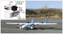
Fig. 1
UAV-borne SAR system"

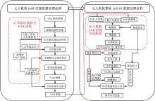
Fig. 2
The flowchart of repeat-pass UAV-borne SAR imaging and InSAR data processing"

Fig. 3
Geometric configuration of non-parallel track interferometric baseline"
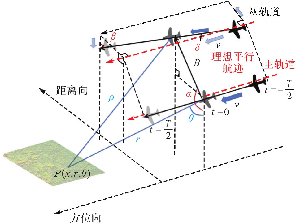

Fig. 4
UAV flight trajectory fitting for SAR imaging"
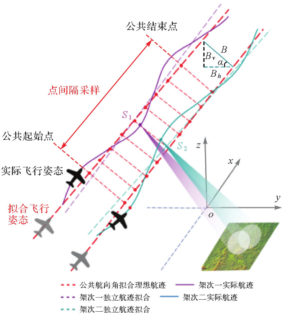
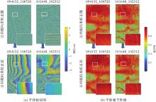
Fig. 5
Coherence and interferograms before and after common heading angle correction"

Tab. 1
Effect of common heading angle correction on interfero-metric coherence and Doppler centroid frequency difference"
| 条带号 | 成像方案 | 平均相干性 | 多普勒中心频率差/Hz |
|---|---|---|---|
| 101648_102312 | 公共航向角校正前 | 0.64 | 3.87 |
| 公共航向角校正后 | 0.65 | 0 | |
| 094132_100520 | 公共航向角校正前 | 0.74 | 10.31 |
| 公共航向角校正后 | 0.78 | 0 |
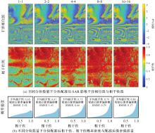
Fig. 6
Comparison of SAR images registration accuracy with multi-scale block"

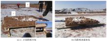
Fig. 7
Simulation experiment of highway deformation settlement plates"
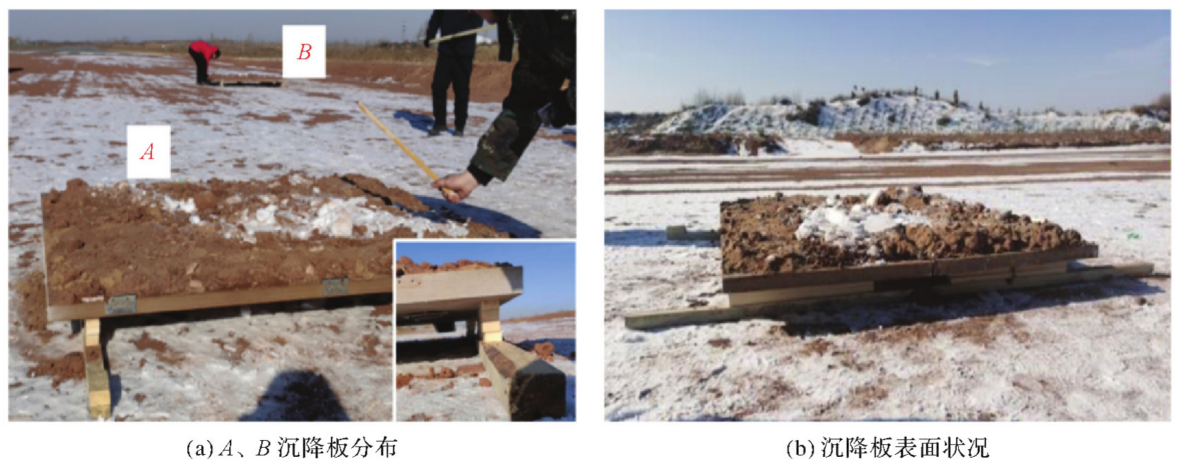
Fig. 8
Airborne SAR flight path projection"
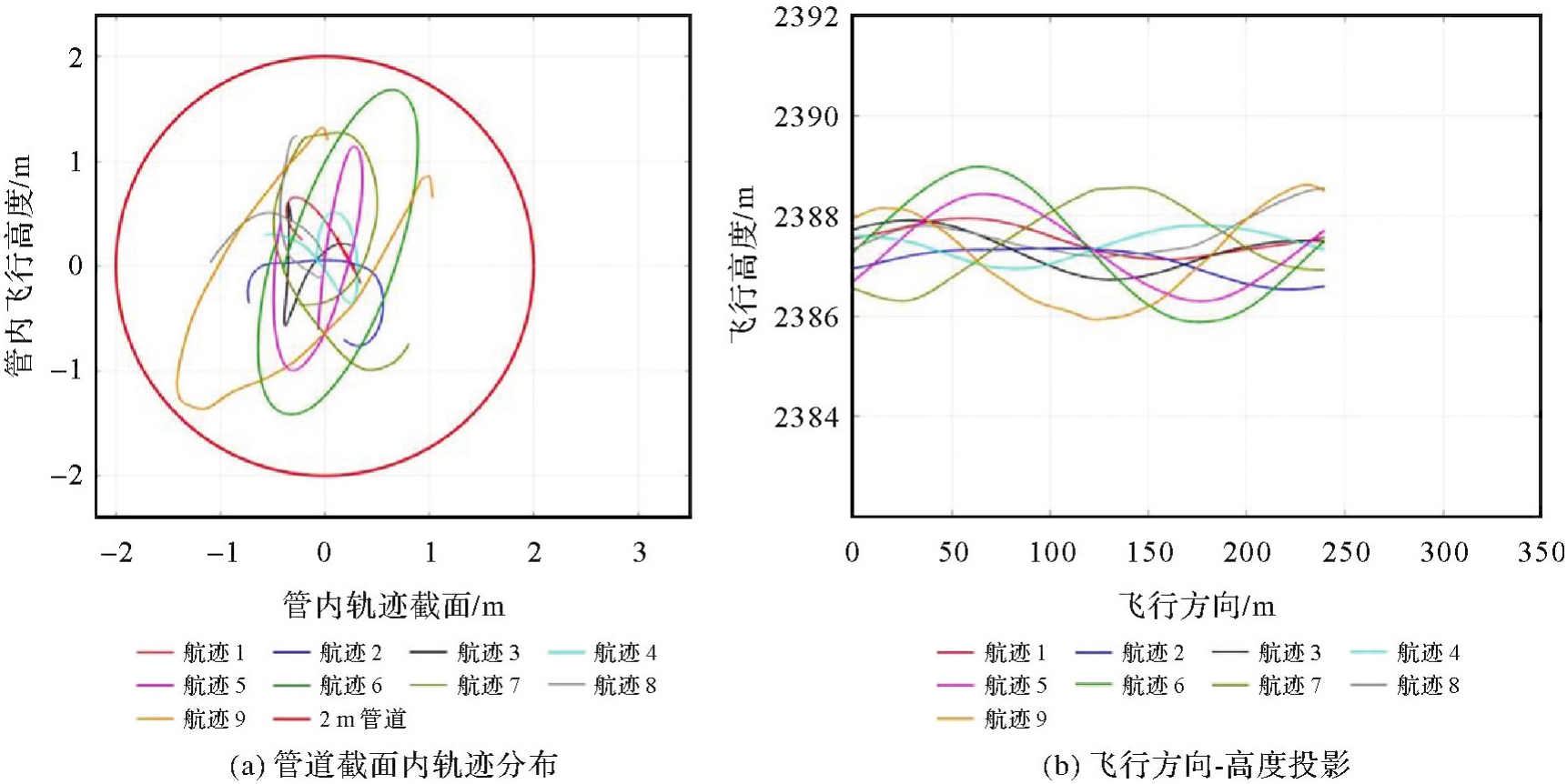
Fig. 9
UAV-brone SAR intensity image"
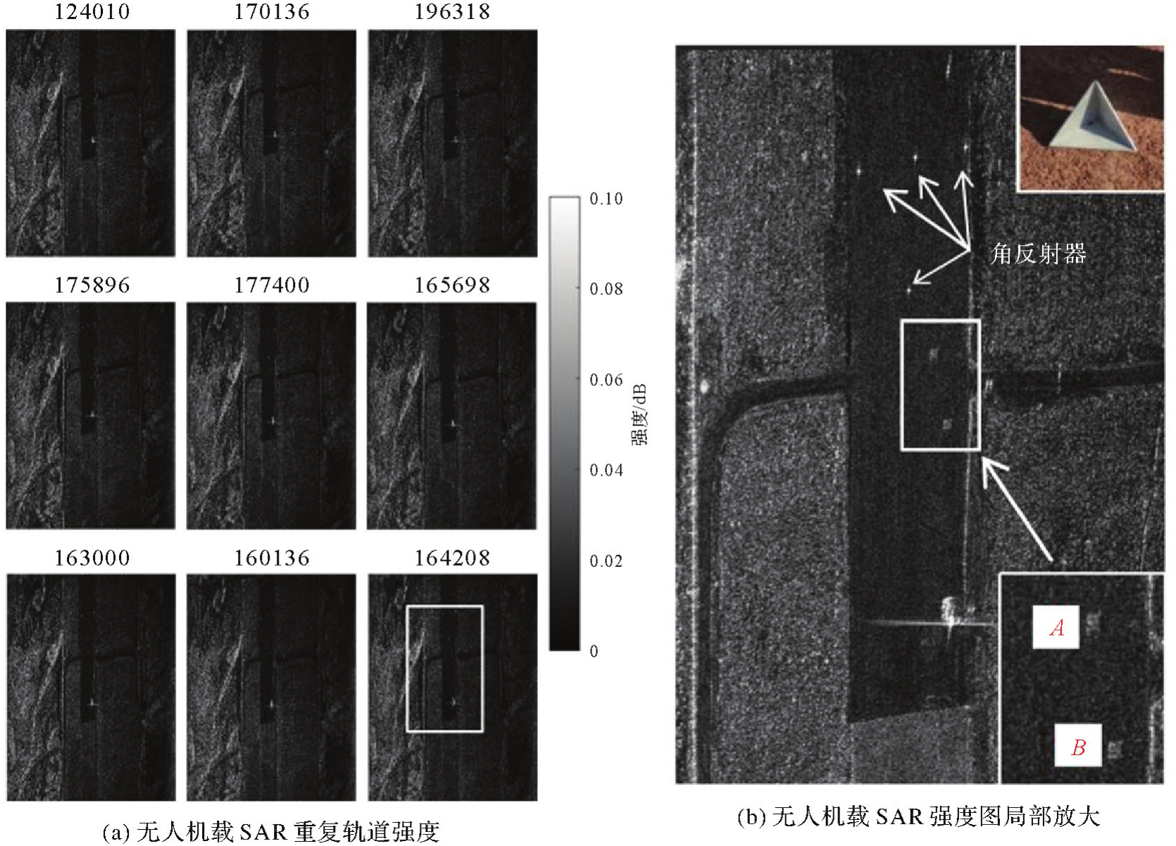
Fig. 10
UAV-brone SAR repeat-pass interferograms"
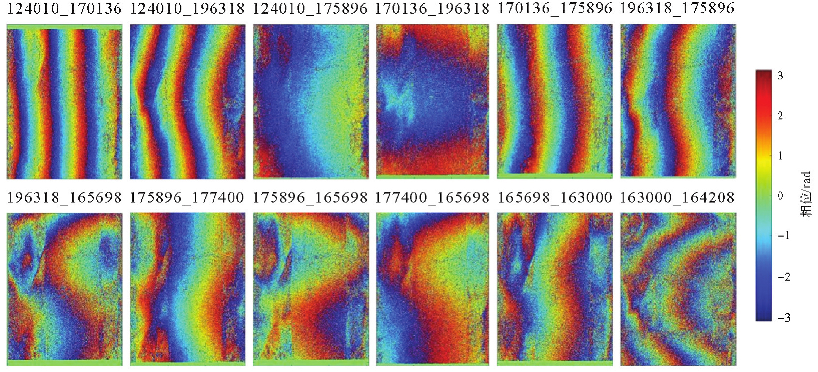
Fig. 11
Goldstein filtered interferograms of UAV-brone SAR"

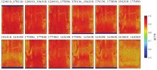
Fig. 12
The coherence of repeat-pass interferograms"
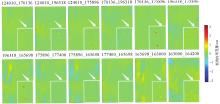
Fig. 13
The unwrapped phase of repeat-pass interferograms"
Tab. 2
LOS deformation results of settlement plates A and B"
| 干涉对 | 试验场景变化 | A板测量值 | A板偏差值 | B板测量值 | B板偏差值 | A、B板理论位移值 |
|---|---|---|---|---|---|---|
| 124010_170136 | 无 | 0.1 | 0.1 | 0.0 | 0 | 0 |
| 124010_196318 | 两侧木板均抽出一块 | 12.8 | -0.6 | 11.5 | -1.9 | 13.4 |
| 124010_175896 | 两侧木板均抽出两块 | 25.5 | -1.4 | 25.1 | -1.8 | 26.9 |
| 170136_196318 | 两侧木板均抽出一块 | 13.7 | 0.3 | 12.5 | -0.9 | 13.4 |
| 170136_175896 | 两侧木板均抽出两块 | 25.1 | -1.8 | 24.5 | -2.4 | 26.9 |
| 196318_175896 | 两侧木板均抽出一块 | 12.8 | -0.6 | 11.9 | -1.5 | 13.4 |
| 196318_165698 | 两侧木板均抽出两块 | 24.3 | -2.6 | 25.0 | -1.9 | 26.9 |
| 175896_177400 | 左侧木板不变 | 1.2(左) | 1.2 | 1.0(左) | 1.0 | 0.0(左) |
| 右侧木板抽出 | 13.8(右) | 0.4 | 12.0(右) | -1.4 | 13.4(右) | |
| 175896_165698 | 两侧木板均抽出一块 | 12.6 | -0.8 | 11.2 | -2.2 | 13.4 |
| 177400_165698 | 左侧木板抽出 | 1.2(右) | 1.2 | 1.3(右) | 1.3 | 0.0(右) |
| 右侧木板不变 | 12.3(左) | -1.1 | 13.7(左) | 0.3 | 13.4(左) | |
| 165698_163000 | 两侧木板均抽出一块 | 12.8 | -0.6 | 11.6 | -1.8 | 13.4 |
| 163000_164208 | 无 | -0.2 | -0.2 | -0.2 | -0.2 | 0 |
| [1] | 唐佳鹏, 何毅, 王培安, 等. 连霍高速公路地表形变InSAR识别与成因分析[J]. 测绘科学, 2024, 49(11): 88-100. |
| TANG Jiapeng, HE Yi, WANG Peian, et al. Identification and causative analysis of surface deformation along the Lianhuo expressway using InSAR[J]. Science of Surveying and Mapping, 2024, 49(11): 88-100. | |
| [2] | XIONG Jiacheng, HE Xiufeng, STEIN A, et al. Deformation monitoring of the embankments using multitemporal InSAR: a case study of the Kangshan embankment[J]. Journal of Geodesy and Geoinformation Science, 2025, 8(1): 12-29. |
| [3] | DAI Keren, RAN Peilian, LI Zhenhong, et al. Land subsidence in Xiong'an New Area, China revealed by InSAR observations[J]. Journal of Geodesy and Geoinformation Science, 2021, 4(1): 70-76. |
| [4] | 张凯想. 无人机摄影测量技术在边坡变形监测中的应用研究[D]. 唐山: 华北理工大学, 2022. |
| ZHANG Kaixiang. Research on the application of UAV photogrammetry technology in slope deformation monitoring[D]. Tangshan: North China University of Science and Technology.2022. | |
| [5] | 陈超, 阿迪力·如苏力, 李晓军, 等. 基于无人机和数字孪生的边坡施工安全动态评估与反馈方法[J]. 测绘通报, 2025(5): 131-137. |
| CHEN Chao, ADILI Rusuli, LI Xiaojun, et al. Dynamic feedback method for slope construction based on UAV and digital twin[J]. Bulletin of Surveying and Mapping. 2025(5): 131-137. | |
| [6] | 童磊. 基于无人机的铁路线路域自主感知及安全检测关键技术研究[D]. 北京: 北京交通大学, 2024. |
| TONG Lei. Research on UAV-based autonomous perception and safety detection key technologies for railway line attachment[D]. Beijing: Beijing Jiaotong University, 2024. | |
| [7] | POLAND M P, ZEBKER H A. Volcano geodesy using InSAR in 2020: the past and next decades[J]. Bulletin of Volcanology, 2022, 84(3): 27. |
| [8] | 朱建军, 李志伟, 胡俊. InSAR变形监测方法与研究进展[J]. 测绘学报, 2017, 46(10): 1717-1733. DOI: 10.11947/j.AGCS.2017.20170350. |
| ZHU Jianjun, LI Zhiwei, HU Jun. Research progress and methods of InSAR for deformation monitoring[J]. Acta Geodaetica et Cartographica Sinica, 2017, 46(10): 1717-1733. DOI: 10.11947/j.AGCS.2017.20170350. | |
| [9] | LIU Guang, ZBIGNIEW P, STEFANO S, et al. Land surface displacement geohazards monitoring using multi-temporal InSAR techniques[J]. Journal of Geodesy and Geoinformation Science, 2021, 4(1): 77-87. |
| [10] | XIAO Ting, HUANG Wei, DENG Yunkai, et al. Long-term and emergency monitoring of Zhongbao landslide using space-borne and ground-based InSAR[J]. Remote Sensing, 2021, 13(8): 1578. |
| [11] | CAO Ning, LEE H, ZAUGG E, et al. Airborne DInSAR results using time-domain backprojection algorithm: a case study over the slumgullion landslide in Colorado with validation using spaceborne SAR, airborne LiDAR, and ground-based observations[J]. IEEE Journal of Selected Topics in Applied Earth Observations and Remote Sensing, 2017, 10(11): 4987-5000. |
| [12] | ROSEN P A, HENSLEY S, WHEELER K, et al. UAVSAR: a new NASA airborne SAR system for science and technology research[C]//Proceedings of 2006 IEEE Conference on Radar. Syracuse: IEEE, 2006: 22-29. |
| [13] | HORN R. E-SAR—the experiment airborne L/C band SAR system of DLR[C]//Proceedings of 1988 IGARSS. Edinburgh: IEEE, 1988: 1025-1026. |
| [14] | REIGBER A, HORN R, NOTTENSTEINER A, et al, Current status of DLR's new F-SAR sensor[C]//Proceedings of the 8th European Conference on Synthetic Aperture Radar. Aachen: [s.n.], 2010: 1-4. |
| [15] | DREUILLET P, PAILLOU P, CANTALLOUBE H, et al. P band data collection and investigations utilizing the RAMSES SAR facility[C]//Proceedings of 2003 IEEE International Geoscience and Remote Sensing Symposium. Toulouse: IEEE, 2003: 4262-4264. |
| [16] | CHRISTENSEN E L, SKOU N, DALL J, et al. EMISAR: an absolutely calibrated polarimetric L- and C-band SAR[J]. IEEE Transactions on Geoscience and Remote Sensing, 1998, 36(6): 1852-1865. |
| [17] | NOHMI H, SHIMADA M, MIYAWAKI M. The repeat-pass interferometric SAR bypi-SAR(L)[C]//Proceedings of 2007 IEEE International Geoscience and Remote Sensing Symposium. Barcelona: IEEE, 2007: 5057-5060. |
| [18] | PERNA S, WIMMER C. X-band airborne differential interferometry: results of the OrbiSAR campaign over the Perugia area[J]. IEEE Transactions on Geoscience and Remote Sensing, 2008, 46(2): 489-503. |
| [19] | XIANG Maosheng, WU Yirong, LI Shaoen, et al. Introduction on an experimental airborne InSAR system[C]//Proceedings of 2005 International Geoscience and Remote Sensing Symposium. Seoul: IEEE, 2005: 4809-4812. |
| [20] | ZHANG Jian, WANG Zhang, HUANG Guoman, et al. CASMSAR: the first Chinese airborne SAR mapping system[C]//Proceedings of 2010 International Society for Optical Engineering. San Diego: SPIE, 2010: 277-284. |
| [21] | 钟雪莲, 向茂生, 郭华东, 等. 机载重轨干涉合成孔径雷达的发展[J]. 雷达学报, 2013, 2(3): 367-381. |
| ZHONG Xuelian, XIANG Maosheng, GUO Huadong, et al. Current development in airborne repeat-pass interferometric synthetic aperture radar[J]. Journal of Radars, 2013, 2(3): 367-381. | |
| [22] | 鲁加国, 陶利, 钟雪莲, 等. L波段机载重轨干涉SAR系统及其试验研究[J]. 雷达学报, 2019, 8(6): 804-819. |
| LU Jiaguo, TAO Li, ZHONG Xuelian, et al. L-band airborne repeat-pass interferometric SAR system and its experimental study[J]. Journal of Radars, 2019, 8(6): 804-819. | |
| [23] | 朱金彪, 潘洁, 仇晓兰, 等. 无人机载双站干涉SAR系统关键技术分析与实验验证研究[J]. 雷达学报, 2023, 12(4): 832-848. |
| ZHU Jinbiao, PAN Jie, QIU Xiaolan, et al. Analysis and experimental validation of key technologies for unmanned aerial vehicle-borne bistatic interferometric synthetic aperture radar[J]. Journal of Radars, 2023, 12(4): 832-848. | |
| [24] | 傅志豪. 无人机载干涉SAR系统性能分析及应用研究[D]. 北京: 应急管理部国家自然灾害防治研究院, 2021. |
| FU Zhihao. Performance analysis and application of UAV interferometric SAR system[D]. Beijing: Nation Natural Disaster Prevention Research Institute of the Ministry of Emergency Mangemet, 2021. | |
| [25] | 方东生, 吕孝雷, 李缘廷, 等. 运动补偿对机载SAR重轨干涉成像的影响分析[J]. 雷达科学与技术, 2016, 14(4): 355-363. |
| FANG Dongsheng, LÜ Xiaolei, LI Yuanting, et al. Effect of motion compensation on airborne repeat pass InSAR imaging[J]. Radar Science and Technology, 2016, 14(4): 355-363. | |
| [26] | 郭智, 丁赤飚, 房建成, 等. 一种高分辨率机载SAR的运动补偿方案[J]. 电子与信息学报, 2004(2): 174-180. |
| GUO Zhi, DING Chibiao, FANG Jiancheng, et al. A motion compensation system for high resolution airborne synthetic aperture radar[J]. Journal of Electronics & Information Technology, 2004(2): 174-180. | |
| [27] | CHEN Jianlai, XING Mengdao, YU Hanwen, et al. Motion compensation/autofocus in airborne synthetic aperture radar: a review[J]. IEEE Geoscience and Remote Sensing Magazine, 2022, 10(1): 185-206. |
| [28] | GOCHO M, KOJIMA S, YAMADA H. Limitation of parallel assumption in repeat-pass InSAR using nonparallel orbits[J]. IEICE Communications Express, 2020, 9(12): 586-592. |
| [29] | 谭鸽伟, 邓云凯. 机载SAR的运动误差的二维空变性及其补偿[J]. 电子与信息学报, 2009, 31(2): 366-369. |
| TAN Gewei, DENG Yunkai. The two-dimensional spatial-variant properties of airborne SAR motion error and its compensation[J]. Journal of Electronics & Information Technology, 2009, 31(2): 366-369. | |
| [30] | 韦顺军, 唐欣欣, 张晓玲. 基于DFT模型的大场景InSAR图像配准[J]. 遥感学报, 2019, 23(5): 859-870. |
| WEI Shunjun, TANG Xinxin, ZHANG Xiaoling. Image registration algorithm for InSAR large scenes via DFT model[J]. Journal of Remote Sensing, 2019, 23(5): 859-870. | |
| [31] | 谢鑫, 邓云开, 杨志军, 等. 基于地形辅助的无人机载InSAR图像分区配准方法[J]. 雷达学报, 2024, 13(1): 116-133. |
| XIE Xin, DENG Yunkai, YANG Zhijun, et al. Topography-assisted UAV InSAR image registration method with image partition[J]. Journal of Radars, 2024, 13(1): 116-133. |
| [1] | Yuansheng HUA, Boyu CHEN, Xinlin LIU, Yun YANG, Song ZHU, Jiasong ZHU, Qingquan LI. Hybrid visual-inertial measurement method of subway tunnel settlement [J]. Acta Geodaetica et Cartographica Sinica, 2025, 54(12): 2182-2193. |
| [2] | Chaolong YAO, Hongrui YOU, Xuanhui HE, Junya LU, Yiqian XIE, Qiong LI, Shuang ZHU, Zhicai LUO. A composite drought index derived from a combination of GNSS PWV/vertical deformation and GRACE/GRACE-FO data [J]. Acta Geodaetica et Cartographica Sinica, 2025, 54(10): 1757-1768. |
| [3] | Hailu CHEN, Yunzhong SHEN. GNSS-assisted InSAR tropospheric delay correction model incorporating vertical stratification and turbulent components [J]. Acta Geodaetica et Cartographica Sinica, 2025, 54(10): 1786-1797. |
| [4] | Minfeng SONG, Xiufeng HE, Xiaolei WANG. Ground-based GNSS-IR ice period detection considering residual signal-to-noise ratio characteristics [J]. Acta Geodaetica et Cartographica Sinica, 2024, 53(12): 2295-2304. |
| [5] | LI Xin, MENG Shuolin, HUANG Guanwen, ZHANG Qin, LI Hanxu. Robust GNSS/SINS positioning based on the SE2(3)-EKF framework [J]. Acta Geodaetica et Cartographica Sinica, 2023, 52(10): 1640-1649. |
| [6] | LIU Tianjun, CHEN Qusen, JIANG Weiping, CHEN Hua, XIA Fengyu, FAN Caoming. Effect of satellite attitude quaternions on BeiDou precise point positioning during the eclipse season [J]. Acta Geodaetica et Cartographica Sinica, 2023, 52(4): 550-558. |
| [7] | WANG Jianrong, YANG Yuanxi, HU Yan, LÜ Yuan, YANG Xiuce, LU Xueliang, CAO Bincai. Preliminary location accuracy assessments of GF-14 stereo mapping satellite without ground control points [J]. Acta Geodaetica et Cartographica Sinica, 2023, 52(1): 8-14. |
| [8] | ZHANG Shuo, CHEN Liping, LI Tieying, YAN Yongzhe, DENG Xiangjin, GU Zheng, ZHENG Yanhong, MA Youqing, QI Chen, LIU Shaochuang. The positioning accuracy of the Lunar surface sampling and packaging mission of the Chang'e-5 probe [J]. Acta Geodaetica et Cartographica Sinica, 2022, 51(5): 631-639. |
| [9] | TANG Xiaofang, ZHAN Zongqian, DING Jiujie, LIU Jiahui, XIONG Zirou. Superpixel spectral features-based automatic fuzzy clustering segmentation for UAV image [J]. Acta Geodaetica et Cartographica Sinica, 2022, 51(5): 677-690. |
| [10] | ZHOU Baoding, ZHANG Wenxiang, HUANG Jincai, LI Qingquan. Indoor and outdoor integrated pedestrian network construction based on crowdsourced data [J]. Acta Geodaetica et Cartographica Sinica, 2022, 51(5): 718-728. |
| [11] | WANG Chenjie, LUO Bin, LI Chengyuan, WANG Wei, YIN Lu, ZHAO Qing. The collaborative mapping and navigation based on visual SLAM in UAV platform [J]. Acta Geodaetica et Cartographica Sinica, 2020, 49(6): 767-776. |
| [12] | WANG Leyang, GAO Hua, FENG Guangcai. Triggering relations and stress effects analysis of two Mw>6 earthquakes in southwest Taiwan based on InSAR and GPS data [J]. Acta Geodaetica et Cartographica Sinica, 2019, 48(10): 1244-1253. |
| [13] | ZHANG Hengjing, CUI Dongdong, CHENG Pengfei. Height nonlinear velocity field and variance fluctuation model construction method for CORS stations [J]. Acta Geodaetica et Cartographica Sinica, 2019, 48(9): 1096-1106. |
| [14] | ZHAO Jianhu, LIANG Wenbiao. Some key points of submarine control network measurement and calculation [J]. Acta Geodaetica et Cartographica Sinica, 2019, 48(9): 1197-1202. |
| [15] | CHEN Zhanglei, LI Chonghui, ZHENG Yong, CHEN Bing, HE Donghan. The minimum analysis of geometric dilution of precision in celestial positioning [J]. Acta Geodaetica et Cartographica Sinica, 2019, 48(7): 879-888. |
| Viewed | ||||||
|
Full text |
|
|||||
|
Abstract |
|
|||||