

Acta Geodaetica et Cartographica Sinica ›› 2025, Vol. 54 ›› Issue (11): 1980-1991.doi: 10.11947/j.AGCS.2025.20250276
• Geodesy and Navigation • Previous Articles Next Articles
Hanyun SONG( ), Xin LI(), Guanwen HUANG, Hang LI
Received:2024-07-15
Revised:2025-11-03
Online:2025-12-15
Published:2025-12-15
Contact:
Xin LI
E-mail:2023126057@chd.edu;lixin2017@chd.edu
About author:SONG Hanyun (2000—), male, postgraduate, majors in GNSS/SINS integrated navigation. E-mail: 2023126057@chd.edu
Supported by:CLC Number:
Hanyun SONG, Xin LI, Guanwen HUANG, Hang LI. Refinement of UAV barometer altimetry model and GNSS/SINS integrated positioning enhancement[J]. Acta Geodaetica et Cartographica Sinica, 2025, 54(11): 1980-1991.
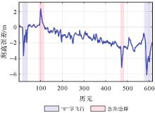
Fig. 1
Correlation between barometric altimetry errors and UAV flight dynamics"
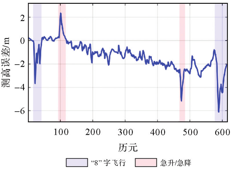
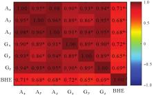
Fig. 2
Spearman correlation heat map"

Fig. 3
Architecture of BHE-Net"

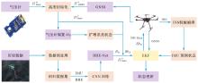
Fig. 4
GNSS/SINS/BARO integrated positioning enhancement process"

Tab. 1
Equipment parameters"
| 参数 | 数值 |
|---|---|
| 陀螺零偏不稳定性/((°)/h) | 10 |
陀螺随机游走/((°)/ | 0.7 |
| 加速度计稳定性/mg | 0.1 |
加速度计随机游走/(mg/ | 0.5 |
| 气压计压力分辨率/mbar | 0.02 |
| 气压计测高标称精度/m | 0.2 |
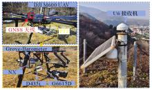
Fig. 5
Experimental installation"

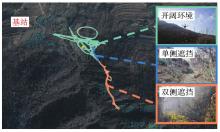
Fig. 6
Experimental scene and flight path"

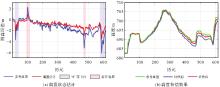
Fig. 7
Bias state estimation and compensation effect of barometer"
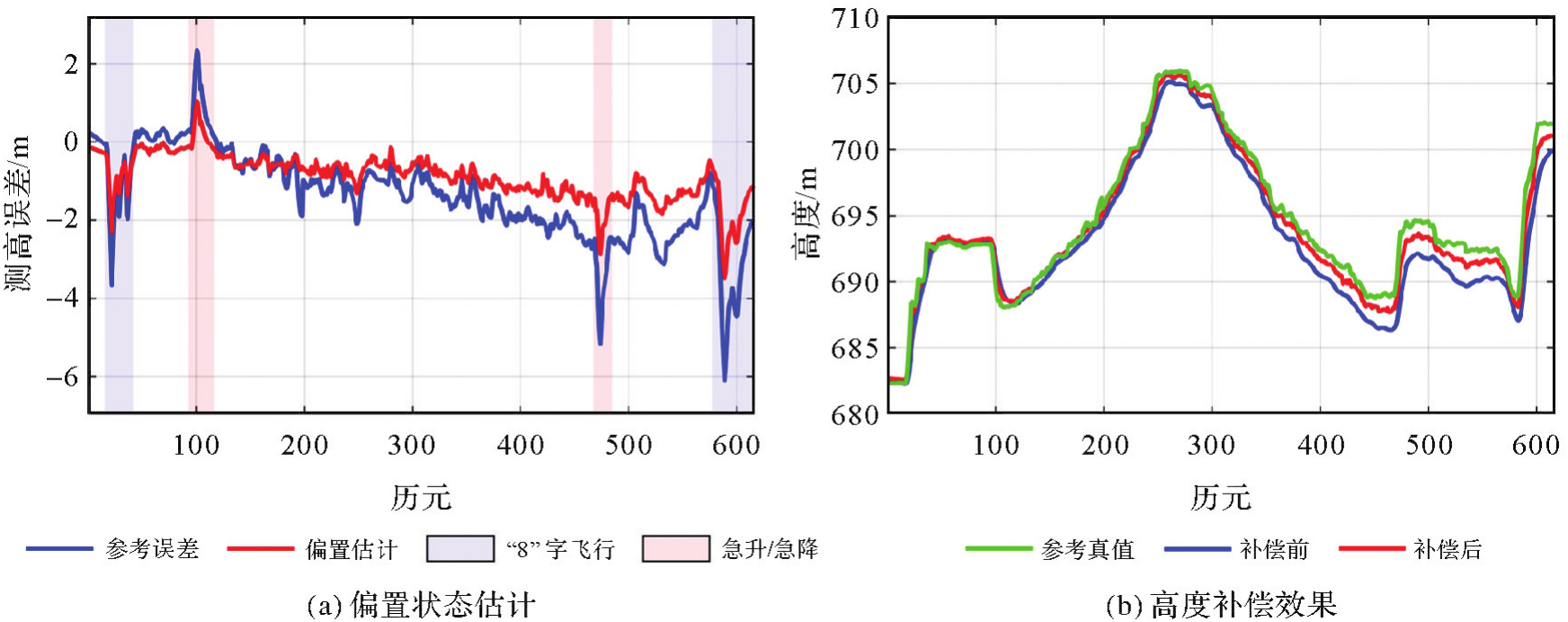
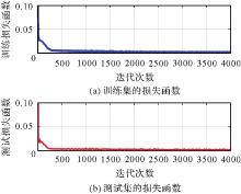
Fig. 8
Loss function"
Fig. 9
Prediction error sequence of BHE-Net test set"
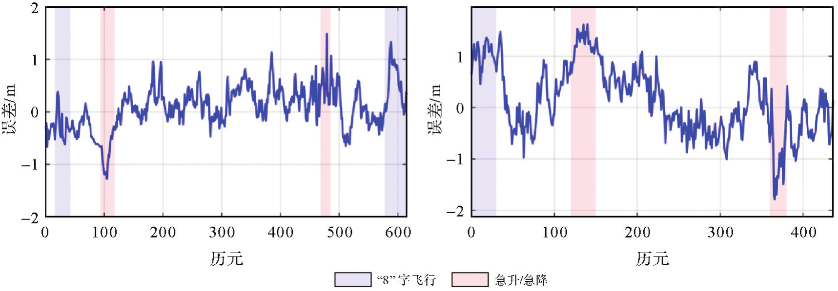
Fig. 10
Classification scene positioning result"

Tab. 2
Analysis of positioning results"
| 场景 | 轴向 | RMSE/m | U向提升/(%) | ||
|---|---|---|---|---|---|
| GNSS/SINS | GNSS/SINS/BARO(固定Rh) | GNSS/SINS/BARO(BHE-Net) | |||
| 开阔机动 | E | 0.547 7 | 0.510 9 | 0.464 4 | 15.20 |
| N | 0.595 3 | 0.590 9 | 0.507 5 | ||
| U | 0.523 9 | 0.459 1 | 0.410 9 | ||
| 3D | 0.963 7 | 0.906 1 | 0.801 3 | ||
| 峡谷遮挡 | E | 0.754 0 | 0.702 6 | 0.678 4 | 37.74 |
| N | 1.287 8 | 1.150 0 | 0.838 1 | ||
| U | 0.283 8 | 0.182 3 | 0.176 7 | ||
| 3D | 1.519 1 | 1.360 0 | 1.092 6 | ||
| GNSS拒止(10 s) | E | 1.474 6 | 0.845 4 | 0.780 9 | 44.20 |
| N | 3.524 1 | 1.766 2 | 1.417 0 | ||
| U | 0.674 2 | 0.379 3 | 0.376 8 | ||
| 3D | 3.879 8 | 1.994 5 | 1.661 1 | ||
| [1] | ZHANG Guohao, HSU L T. Intelligent GNSS/INS integrated navigation system for a commercial UAV flight control system[J]. Aerospace Science and Technology, 2018, 80: 368-380. |
| [2] | GUERRA A, DARDARI D, DJURIC P M. Joint indoor localization and navigation of UAVs for network formation control[C]//Proceedings of 2018 Asilomar Conference on Signals, Systems, and Computers. Pacific Grove: IEEE, 2018: 13-19. |
| [3] | CHIANG Kaiwei, CHANG H W, LI Yuhua, et al. Assessment for INS/GNSS/odometer/barometer integration in loosely-coupled and tightly-coupled scheme in a GNSS-degraded environment[J]. IEEE Sensors Journal, 2020, 20(6): 3057-3069. |
| [4] | ZHU Ni, MARAIS J, BETAILLE D, et al. GNSS position integrity in urban environments: a review of literature[J]. IEEE Transactions on Intelligent Transportation Systems, 2018, 19(9): 2762-2778. |
| [5] | SCHEIERMANN S. MEMS传感器——无人机的核心[J]. 传感器世界, 2019, 25(5): 36-40. |
| SCHEIERMANN S. MEMS sensors—hearts of UAVs[J]. Sensor World, 2019, 25(5): 36-40. | |
| [6] | SIRIKONDA S, PARAYITAM L, HABLANI H B. Performance enhancement of NavIC with low-cost MEMS-IMU, barometer, and magnetometer[J]. IEEE Access, 2025(13): 17303-17324. |
| [7] | SABATINI A M, GENOVESE V. A sensor fusion method for tracking vertical velocity and height based on inertial and barometric altimeter measurements[J]. Sensors, 2014, 14(8): 13324-13347. |
| [8] | YEN S W, VAN GRAAS F, DE HAAG M U. Positioning with two satellites and known receiver clock, barometric pressure and radar elevation[J]. GPS Solutions, 2016, 20(4): 885-899. |
| [9] | CHEN H, WU W, ZHANG S, et al. A GNSS/LiDAR/IMU pose estimation system based on collaborative fusion of factor map and filtering[J]. Remote Sensing, 2023, 15(3): 790. |
| [10] | 李彦杰, 杨元喜, 何海波. 附加约束条件对GNSS/INS组合导航结果的影响分析[J]. 武汉大学学报(信息科学版), 2017, 42(9): 1249-1255. |
| LI Yanjie, YANG Yuanxi, HE Haibo. Effects analysis of constraints on GNSS/INS integrated navigation[J]. Geomatics & Information Science of Wuhan University, 2017, 42(9): 1249-1255. | |
| [11] | SON Y, OH S. A barometer-IMU fusion method for vertical velocity and height estimation[C]//Proceedings of 2015 IEEE SENSORS. Busan: IEEE, 2015: 1-4. |
| [12] | BAO Le, LI Kai, LEE J, et al. An enhanced indoor three-dimensional localization system with sensor fusion based on ultra-wideband ranging and dual barometer altimetry[J]. Sensors, 2024, 24(11): 3341. |
| [13] | SHIN E H. Estimation techniques for low-cost inertial navigation[D]. Calgary: University of Calgary, 2005. |
| [14] | TANIGAWA M, LUINGE H, SCHIPPER L, et al. Drift-free dynamic height sensor using MEMS IMU aided by MEMS pressure sensor[C]//Proceedings of the 5th Workshop on Positioning, Navigation and Communication. Hannover: IEEE, 2008: 191-196. |
| [15] | LI Zehua, SHANG Junna, YAO Ziyang. Indoor integrated navigation on PDR/Wi-Fi/barometer via factor graph with local attention[J]. IEEE Sensors Journal, 2023, 23(22): 27613-27623. |
| [16] | PARVIAINEN J, KANTOLA J, COLLIN J. Differential barometry in personal navigation[C]//Proceedings of 2008 IEEE/ION Position, Location and Navigation Symposium. Monterey: IEEE, 2008: 148-152. |
| [17] | 黄鹤, 刘一恒, 赵熙, 等. 多层多源信息融合旋翼无人机测高算法[J]. 中国惯性技术学报, 2018, 26(3): 316-322, 329. |
| HUANG He, LIU Yiheng, ZHAO Xi, et al. Multi-layer multi-source information fusion algorithm for hovering UAV height measurement[J]. Journal of Chinese Inertial Technology, 2018, 26(3): 316-322, 329. | |
| [18] | ZHANG Jieying, EDWAN E, ZHOU Junchuan, et al. Performance investigation of barometer aided GPS/MEMS-IMU integration[C]//Proceedings of 2012 IEEE/ION Position, Location and Navigation Symposium. Myrtle Beach: IEEE, 2012: 598-604. |
| [19] | PARK J, LEE Dongsun, PARK C. Implementation of vehicle navigation system using GNSS, INS, odometer and barometer[J]. Journal of Positioning, Navigation, and Timing, 2015, 4(3): 141-150. |
| [20] | XU Dacheng, YANG Zhimei, ZHAO Heming, et al. A temperature compensation method for MEMS accelerometer based on LM_BP neural network[C]//Proceedings of 2016 IEEE SENSORS. Orlando: IEEE, 2016: 1-3. |
| [21] | LIU Yaohua, LUO Qingsong, ZHOU Yimin. Deep learning-enabled fusion to bridge GPS outages for INS/GPS integrated navigation[J]. IEEE Sensors Journal, 2022, 22(9): 8974-8985. |
| [22] | ZHANG Shuning, WANG Ershen, WANG Yongkang, et al. A low-cost UAV swarm relative positioning architecture based on BDS/barometer/UWB[J]. IEEE Sensors Journal, 2024, 24(23): 39659-39668. |
| [23] | 马旭, 程咏梅, 郝帅. 面向无人机高度融合估计的自适应S滤波方法[J]. 中国惯性技术学报, 2013, 21(5): 604-608. |
| MA Xu, CHENG Yongmei, HAO Shuai. Adaptive S filtering method for UAV height fusion estimation[J]. Journal of Chinese Inertial Technology, 2013, 21(5): 604-608. | |
| [24] | ZHAO Xiaoxi, MENG Yue, QI Fei, et al. A vertical channel-enhanced fusion method based on RINS and barometric altimeter for UAVs in GNSS denial environments[J]. IEEE Transactions on Instrumentation and Measurement, 2023, 72: 1-12. |
| [25] | CHE Yifan, DONG Jiuxiang. A real-time, robust visual-inertial navigation system tightly coupled with GNSS and barometer[J]. IEEE Sensors Letters, 2024, 8(6): 1-4. |
| [26] | CAO Yin, XU Wenyuan, LIN Bo, et al. A method for temperature error compensation in fiber-optic gyroscope based on machine learning[J]. Optik, 2022, 256: 168765. |
| [27] | CHEN Hua, AGGARWAL P, TAHA T M, et al. Improving inertial sensor by reducing errors using deep learning methodology[C]//Proceedings of 2018 IEEE National Aerospace and Electronics Conference. Dayton: IEEE, 2018: 197-202. |
| [28] | JIANG Changhui, CHEN Shuai, CHEN Yuwei, et al. A MEMS IMU de-noising method using long short term memory recurrent neural networks (LSTM-RNN)[J]. Sensors, 2018, 18(10): 3470. |
| [29] | LI Xin, LI Hanxu, HUANG Guanwen, et al. Non-holonomic constraint (NHC)-assisted GNSS/SINS positioning using a vehicle motion state classification (VMSC)-based convolution neural network[J]. GPS Solutions, 2023, 27(3): 144. |
| [30] | 李晗旭, 李昕, 黄观文, 等. 速度分类的LSTM神经网络辅助GNSS/SINS车载定位方法[J]. 武汉大学学报(信息科学版), 2025, 50(7): 1311-1320. |
| LI Hanxu, LI Xin, HUANG Guanwen, et al. LSTM neural network assisted GNSS/SINS vehicle positioning based on speed classification[J]. Geomatics and Information Science of Wuhan University, 2025, 50(7): 1311-1320. | |
| [31] | WANG Jian, HAN Houzeng, LIU Fei, et al. Performance analysis of GNSS/MIMU tight fusion positioning model with complex scene feature constraints[J]. Journal of Geodesy and Geoinformation Science, 2021, 4(2): 1-13. |
| [32] | 李昕, 孟硕林, 黄观文, 等. GNSS/SINS定位稳健SE2(3)-EKF方法[J]. 测绘学报, 2023, 52(10): 1640-1649. DOI: 10.11947/j.AGCS.2023.20220526. |
| LI Xin, MENG Shuolin, HUANG Guanwen, et al. Robust GNSS/SlNS positioning based on the SE2(3)-EKF framework[J]. Acta Geodaetica et Cartographica Sinica, 2023, 52(10): 1640-1649. DOI: 10.11947/j.AGCS.2023.20220526. |
| [1] | Yarong LUO, Wentao LU, Chi GUO, Jingnan LIU. Left-handed symmetry equivariant filtering model and algorithm for GNSS/INS integrated navigation [J]. Acta Geodaetica et Cartographica Sinica, 2025, 54(8): 1389-1403. |
| [2] | Jinbin ZHANG, Jun ZHU, Pei DANG, Yuxuan ZHOU, Bowen YANG. Live-streaming geographic information service: remote immersive perception of on-site conditions based on VR panoramas [J]. Acta Geodaetica et Cartographica Sinica, 2025, 54(12): 2276-2286. |
| [3] | Wei PENG, Jing YANG, Haiqiang FU, Jianjun ZHU, Dong ZENG. UAV-borne repeat-pass InSAR data processing method considering motion error characteristics [J]. Acta Geodaetica et Cartographica Sinica, 2025, 54(11): 1954-1967. |
| [4] | Yarong LUO, Chi GUO, Wei OUYANG, Jingnan LIU. GNSS/SINS integrated navigation method considering the geometric property of biases state [J]. Acta Geodaetica et Cartographica Sinica, 2025, 54(1): 26-39. |
| [5] | Jichao LÜ, Rui ZHANG, Xu HE, Ruikai HONG, Age SHAMA, Guoxiang LIU. Multi-branch network assessment and dynamic change analysis of wide-area landslide susceptibility [J]. Acta Geodaetica et Cartographica Sinica, 2025, 54(1): 104-122. |
| [6] | Fubing ZHANG, Qun SUN, Jingzhen MA, Shijie SUN, Bowei WEN. An intelligent classification method for building shape based on fusion of global and local features [J]. Acta Geodaetica et Cartographica Sinica, 2024, 53(9): 1842-1852. |
| [7] | Li YAN, Yinghao ZHAO, Jicheng DAI, Bo XU, Hong XIE, Yuquan ZHOU. Intelligent perception measurement technology of autonomous UAV for unknown environment [J]. Acta Geodaetica et Cartographica Sinica, 2024, 53(6): 999-1012. |
| [8] | Xunqiang GONG, Hongyu WANG, Tieding LU, Wei YOU. A general progressive decomposition long-term prediction network model for high-speed railway bridge pier settlement [J]. Acta Geodaetica et Cartographica Sinica, 2024, 53(6): 1113-1127. |
| [9] | Hao XU, Qin ZHANG, Li WANG, Bao SHU, Yuan DU, Guanwen HUANG. Intelligent site selection method for UAV-dropped GNSS landslide monitoring equipment [J]. Acta Geodaetica et Cartographica Sinica, 2024, 53(6): 1140-1153. |
| [10] | San JIANG, Yichen MA, Qingquan LI, Wanshou JIANG, Bingxuan GUO, Lizhe WANG. Parallel SfM-based 3D reconstruction for unordered UAV images [J]. Acta Geodaetica et Cartographica Sinica, 2024, 53(5): 946-958. |
| [11] | Zhi LIU, Shuyuan YANG, Zifan YU, Zhixi FENG, Quanwei GAO, Min WANG. Fast SAR autofocus based on convolutional neural networks [J]. Acta Geodaetica et Cartographica Sinica, 2024, 53(4): 610-619. |
| [12] | MU Mengxue, ZHAO Long. A distributed GNSS/SINS/odometer resilient fusion navigation method for land vehicle [J]. Acta Geodaetica et Cartographica Sinica, 2024, 53(3): 425-434. |
| [13] | JIANG San, LIU Kai, LI Qingquan, JIANG Wanshou. Learned local features for SfM reconstruction of UAV images [J]. Acta Geodaetica et Cartographica Sinica, 2024, 53(2): 321-331. |
| [14] | XIAO Teng, WANG Xin, MEI Xi, YE Zhiwei, YAN Qingsong, DENG Fei. Robust merging of subblock reconstructions for parallel structure from motion in photogrammetry [J]. Acta Geodaetica et Cartographica Sinica, 2024, 53(2): 332-343. |
| [15] | LIAO Zhaohong, ZHANG Yichen, YANG Biao, LIN Mingchun, SUN Wenbo, GAO Zhi. Monocular height estimation method of remote sensing image based on Swin Transformer-CNN and its application in highway road construction sites [J]. Acta Geodaetica et Cartographica Sinica, 2024, 53(2): 344-352. |
| Viewed | ||||||
|
Full text |
|
|||||
|
Abstract |
|
|||||