| [1] |
中国卫星导航系统管理办公室.北斗卫星导航系统介绍[EB/OL]. [2023-02-12].http://www.csno-tarc.cn/system/introduction.
|
|
China Satellite Navigation Office. BeiDou navigation satellite system introduction[EB/OL]. [2023-02-12]. http://www.csno-tarc.cn/system/introduction.
|
| [2] |
杨元喜, 许扬胤, 李金龙, 等. 北斗三号系统进展及性能预测:试验验证数据分析[J]. 中国科学:地球科学, 2018, 48(5):584-594.
|
|
YANG Yuanxi, XU Yangyin, LI Jinlong, et al. Progress and performance evaluation of BeiDou global navigation satellite system: data analysis based on BDS-3 demonstration system[J]. Scientia Sinica (Terrae), 2018, 48(5):584-594.
|
| [3] |
黄文德, 康娟, 张利云, 等. 北斗卫星导航定位原理与方法[M]. 北京: 科学出版社, 2019: 17.
|
|
HUANG Wende, KANG Juan, ZHANG Liyun, et al. Principle and method of BeiDou satellite navigation and positioning[M]. Beijing: Science Press, 2019: 17.
|
| [4] |
张双成, 王倩怡, 刘奇, 等. BDS精密相对定位精度的GAMIT分析[J]. 测绘科学, 2018, 43(12):92-97.
|
|
ZHANG Shuangcheng, WANG Qianyi, LIU Qi, et al. Analysis of precision relative positioning accuracy of BDS by GAMIT[J]. Science of Surveying and Mapping, 2018, 43(12):92-97.
|
| [5] |
王西龙, 许小龙, 赵齐乐. 北斗三号系统信号质量分析及轨道精度验证[J]. 武汉大学学报(信息科学版), 2023, 48(4):611-619.
|
|
WANG Xilong, XU Xiaolong, ZHAO Qile. Signal quality analysis and orbit accuracy verification of BDS-3[J]. Geomatics and Information Science of Wuhan University, 2023, 48(4):611-619.
|
| [6] |
程军龙, 王旺, 马立烨, 等. 北斗三号观测数据质量及定位精度初步评估[J]. 测绘通报, 2019(8):1-7.
|
|
CHENG Junlong, WANG Wang, MA Liye, et al. Preliminary analysis of observation quality and positioning precision for BDS-3 satellites[J]. Bulletin of Surveying and Mapping, 2019(8):1-7.
|
| [7] |
符宏伟. GNSS静态相对定位精度分析与比较[J]. 导航定位学报, 2021, 9(5):114-120.
|
|
FU Hongwei. Precision analysis and comparison of GNSS static relative positioning[J]. Journal of Navigation and Positioning, 2021, 9(5):114-120.
|
| [8] |
SU Xiaoning, MENG Guojie, SUN Haili, et al. Positioning performance of BDS observation of the crustal movement observation network of China and its potential application on crustal deformation[J]. Sensors, 2018, 18(10):3353.
|
| [9] |
中国卫星导航系统管理办公室测试评估研究中心.北斗系统状态:星座状态 [EB/OL].[2023-02-12].http://www.csno-tarc.cn/system/constellation.
|
|
Test and Assessment Research Center of China Satellite Navigation Office. BeiDou navigation system status: constellation status [EB/OL]. [2023-02-12]. http://www.csno-tarc.cn/system/constellation.
|
| [10] |
HERRING T A, KING R W, MCCLUSKY S C. GLOBK reference manual: global Kalman filter VLBI and GPS analysis program, release 10.6 [EB/OL]. [2023-02-12].http://geoweb.mit.edu/gg/docs/GLOBK_Ref.pdf.
|
| [11] |
HERRING T A, KING R W, MCKLUSKY S C. GAMIT reference manual: GPS analysis at MIT, version 10.7 [EB/OL]. [2023-02-12].http://geoweb.mit.edu/gg/docs/GAMIT_Ref.pdf.
|
| [12] |
SAASTAMOINEN J. Contributions to the theory of atmospheric refraction[J]. Bulletin Géodésique (1946—1975), 1972, 105(1):279-298.
|
| [13] |
BOEHM J, NIELL A, TREGONING P, et al. Global mapping function (GMF): a new empirical mapping function based on numerical weather model data[J]. Geophysical Research Letters, 2006, 33(7):304-307.
|
| [14] |
LYARD F, LEFEVRE F, LETELLIER T, et al. Modelling the global ocean tides: modern insights from FES2004[J]. Ocean Dyna-mics, 2006, 56(5):394-415.
|
| [15] |
BOS M S, FERNANDES R M S, WILLIAMS S D P, et al. Fast error analysis of continuous GNSS observations with missing data[J]. Journal of Geodesy, 2013, 87(4):351-360.
|
| [16] |
NIKOLAIDIS R. Observation of geodetic and seismic deformation with the global positioning system [D]. San Diego: University of California, 2002.
|
| [17] |
ZHANG Jie, BOCK Y, JOHNSON H, et al. Southern California permanent GPS geodetic array: error analysis of daily position estimates and site velocities[J]. Journal of Geophical Research, 1997, 102(B8):18035-18055.
|
| [18] |
WILLIAMS S D P, BOCK Y, FANG Peng, et al. Error analysis of continuous GPS position time series[J]. Journal of Geophysical Research: Solid Earth, 2004, 109(B3):B03412.
|
| [19] |
张小红, 丁乐乐. 北斗二代观测值质量分析及随机模型精化[J]. 武汉大学学报(信息科学版), 2013, 38(7):832-836.
|
|
ZHANG Xiaohong, DING Lele. Quality analysis of the second generation compass observables and stochastic model refining[J]. Geomatics and Information Science of Wuhan University, 2013, 38(7):832-836.
|
| [20] |
王阅兵, 甘卫军, 陈为涛, 等. 北斗导航系统精密单点定位在地壳运动监测中的应用分析[J]. 测绘学报, 2018, 47(1):48-56. DOI: 10.11947/j.AGCS.2018.20170147.
|
|
WANG Yuebing, GAN Weijun, CHEN Weitao, et al. The analysis of precise point positioning of BeiDou navigation satellite system application in crustal motion monitoring[J]. Acta Geodaetica et Cartographica Sinica, 2018, 47(1):48-56. DOI: 10.11947/j.AGCS.2018.20170147.
|
| [21] |
施闯, 魏娜, 李敏, 等. 利用北斗系统建立和维持国家大地坐标参考框架的方法研究[J]. 武汉大学学报(信息科学版), 2017, 42(11):1635-1643.
|
|
SHI Chuang, WEI Na, LI Min, et al. Approaches to realize and maintain national terrestrial reference frame based on BDS data[J]. Geomatics and Information Science of Wuhan University, 2017, 42(11):1635-1643.
|
| [22] |
李星星, 李婕, 袁勇强, 等. 北斗三号卫星经验型太阳光压模型分析与精化[J]. 测绘学报, 2022, 51(8):1680-1689. DOI: 10.11947/j.AGCS.2022.20210532.
|
|
LI Xingxing, LI Jie, YUAN Yongqiang, et al. Assessment and improvement of the empirical solar radiation pressure models for BDS-3 satellites[J]. Acta Geodaetica et Cartographica Sinica, 2022, 51(8):1680-1689. DOI: 10.11947/j.AGCS.2022.20210532.
|
| [23] |
CHEN Qiuli, YANG Hui, CHEN Zhonggui, et al. Solar radiation pressure modeling and application of BDS satellites[J]. Journal of Geodesy and Geoinformation Science, 2020, 3(2):45-52.
|
| [24] |
李星星, 张伟, 袁勇强, 等. GNSS卫星精密定轨综述:现状、挑战与机遇[J]. 测绘学报, 2022, 51(7):1271-1293. DOI: 10.11947/j.AGCS.2022.20220173.
|
|
LI Xingxing, ZHANG Wei, YUAN Yongqiang, et al. Review of GNSS precise orbit determination: status, challenges, and opportunities[J]. Acta Geodaetica et Cartographica Sinica, 2022, 51(7):1271-1293. DOI: 10.11947/j.AGCS.2022.20220173.
|
| [25] |
刘路, 郭金运, 周茂盛, 等. GNSS广播星历轨道和钟差精度分析[J]. 武汉大学学报(信息科学版), 2022, 47(7):1122-1132.
|
|
LIU Lu, GUO Jinyun, ZHOU Maosheng, et al. Accuracy analysis of GNSS broadcast ephemeris orbit and clock offset[J]. Geomatics and Information Science of Wuhan University, 2022, 47(7):1122-1132.
|
| [26] |
张小红, 李盼, 李星星, 等. 天线相位中心改正模型对PPP参数估计的影响[J]. 武汉大学学报(信息科学版), 2011, 36(12):1470-1473.
|
|
ZHANG Xiaohong, LI Pan, LI Xingxing, et al. Influcence of antenna phase center correction model on precise point positioning[J]. Geomatics and Information Science of Wuhan University, 2011, 36(12):1470-1473.
|
| [27] |
张胜凯, 左耀文, 鄂栋臣, 等. 天线相位中心改正模型对南极GPS基线解算的影响[J]. 测绘科学, 2018, 43(8):151-156.
|
|
ZHANG Shengkai, ZUO Yaowen, E Dongchen, et al. The impact of antenna phase center correction model on the GPS baseline solution in Antarctic[J]. Science of Surveying and Mapping, 2018, 43(8):151-156.
|
| [28] |
任琛, 王晨, 李振洪. 北斗三号卫星天线相位中心改正模型对精密定轨和定位的影响[J]. 大地测量与地球动力学, 2022, 42(12):1227-1232,1261.
|
|
REN Chen, WANG Chen, LI Zhenhong. Impact of satellites antenna phase center correction model on BDS-3 precise orbit determination and positioning[J]. Journal of Geodesy and Geodynamics, 2022, 42(12):1227-1232,1261.
|
| [29] |
QU Ziyang, GUO Jing, ZHAO Qile. Phase center corrections for BDS IGSO and MEO satellites in IGb14 and IGSR3 frame[J]. Remote Sensing, 2021, 13(4):745.
|
| [30] |
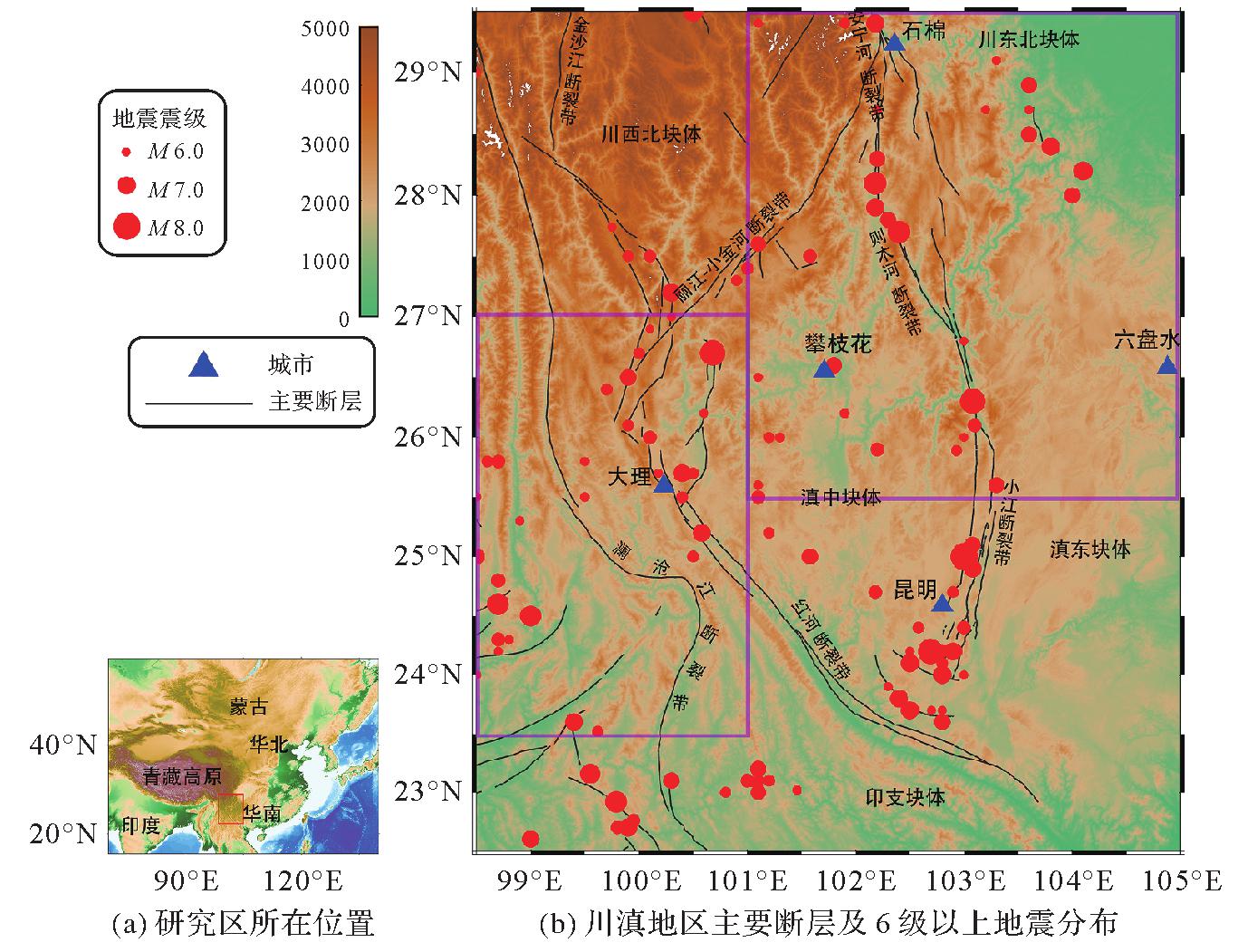
乔学军, 王琪, 杜瑞林. 川滇地区活动地块现今地壳形变特征[J]. 地球物理学报, 2004, 47(5):806-812.
|
|
QIAO Xuejun, WANG Qi, DU Ruilin. Characteristics of current crustal deformation of active blocks in the Sichuan-Yunnan region[J]. Chinese Journal of Geophysics, 2004, 47(5):806-812.
|


 ), 孟国杰1(