


测绘学报 ›› 2026, Vol. 55 ›› Issue (2): 344-358.doi: 10.11947/j.AGCS.2026.20250310
胡浩鹏( ), 吴杭彬(), 战仕浩, 温在豪, 刘春
收稿日期:2025-07-31
修回日期:2026-01-05
出版日期:2026-03-13
发布日期:2026-03-13
通讯作者:
吴杭彬
E-mail:haopenghu@tongji.edu.cn;hb@tongji.edu.cn
作者简介:胡浩鹏(2001—),男,博士生,研究方向为道路要素变化检测与高精地图更新。 E-mail:haopenghu@tongji.edu.cn
基金资助:
Haopeng HU(), Hangbin WU(), Shihao ZHAN, Zaihao WEN, Chun LIU
Received:2025-07-31
Revised:2026-01-05
Online:2026-03-13
Published:2026-03-13
Contact:
Hangbin WU
E-mail:haopenghu@tongji.edu.cn;hb@tongji.edu.cn
About author:HU Haopeng (2001—), male, PhD candidate, majors in road elements change detection and high-definition map updates. E-mail: haopenghu@tongji.edu.cn
Supported by:摘要:
视觉传感器是目前道路众源变化检测中最常见的感知传感器。针对视觉SLAM在道路杆状物众源变化检测中的精度与稳健性瓶颈,本文提出一套视觉点云质量优化支持的道路杆状物变化检测技术框架。首先,通过融合语义约束、激光点云深度与GNSS全局校正,构建视觉点云优化方法,显著提升了轨迹精度与点云质量;其次,基于优化后的视觉点云,实现道路杆状物的精准提取与定位;然后,引入基于哈希映射的快速匹配策略,完成跨期杆状物的鲁棒变化检测;最后,在同济大学周边采集的两期试验数据上验证了整体流程的有效性。试验表明,本文方法的轨迹平均绝对误差(MAE)与均方根误差(RMSE)分别降低68.39%和65.65%,点云密度平均提升57.97%。在要素定位与变化检测任务中,杆状物要素的平均定位误差在单一方向上为2~3 m,平均平面误差约为3.5 m,杆状物匹配精度达到94.8%,新增与移除杆状物的变化检测准确率与召回率均为100%。结果证明了本文方法的有效性和稳定性,证实了多源数据融合与优化技术在道路杆状物变化检测中的应用价值,为高精地图变化检测与道路设施智能化管理提供了可靠的技术路径。
中图分类号:
胡浩鹏, 吴杭彬, 战仕浩, 温在豪, 刘春. 视觉点云质量优化支持的道路杆状物变化检测[J]. 测绘学报, 2026, 55(2): 344-358.
Haopeng HU, Hangbin WU, Shihao ZHAN, Zaihao WEN, Chun LIU. Road pole-like object change detection supported by visual point cloud quality optimization[J]. Acta Geodaetica et Cartographica Sinica, 2026, 55(2): 344-358.
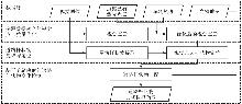
图1
道路杆状物视觉众源变化检测算法总体框架"
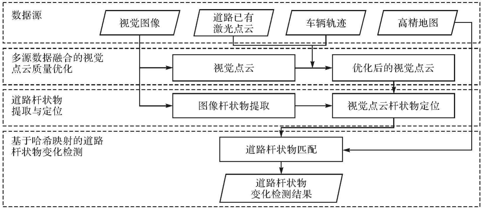
图2
视觉点云优化总体框架"
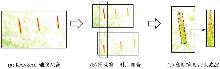
图3
道路杆状物点云的优化定位流程"
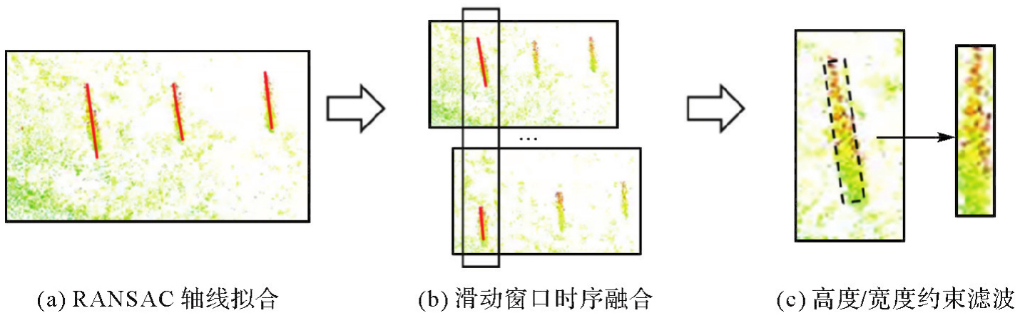
表1
道路杆状物平均定位误差"
| 变化情况 | 前期有杆状物 | 后期有杆状物 | 前后有语义变化 | 检测方法 |
|---|---|---|---|---|
| 新增 | 否 | 是 | 否 | 在杆状物匹配阶段,若当前期目标的候选匹配集合为空,则标记为新增候选。通过核密度估计过滤因噪声或临时障碍物导致的误检 |
| 移除 | 是 | 否 | 否 | 移除检测需验证点云缺失区域的持续性,并确认底部结构是否匹配历史数据,避免误判 |
| 语义变化 | 是 | 是 | 否 | 对两期同一杆状物的语义标签进行一致性校验,确定变更候选集,随后通过试验设备采集的图像数据多重验证,排除遮挡或误检 |
图4
图像数据多重验证杆状物语义变化"
表2
试验数据信息"
| 期 | 采集时间 | GNSS | Mono | 采集周期/s | 采集长度/m | 图像数 |
|---|---|---|---|---|---|---|
| D1 | 2024-10 | √ | √ | 240 | 3 243.21 | 2401 |
| D2 | 2025-04 | √ | √ | 247 | 3 263.67 | 2409 |
表3
两种方法的准确性和运行时间对比"
| 期 | ORB-SLAM2 | 本文方法 | 优化提升 | |||||
|---|---|---|---|---|---|---|---|---|
| MAE/m | RMSE/m | 时间/s | MAE/m | RMSE/m | 时间/s | MAE/(%) | RMSE/(%) | |
| D1 | 5.798 | 5.440 | 694 | 1.625 | 1.762 | 952 | 71.97 | 67.60 |
| D2 | 5.941 | 6.047 | 682 | 2.091 | 2.196 | 972 | 64.80 | 63.69 |
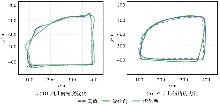
图5
视觉点云几何精度优化前后对比"
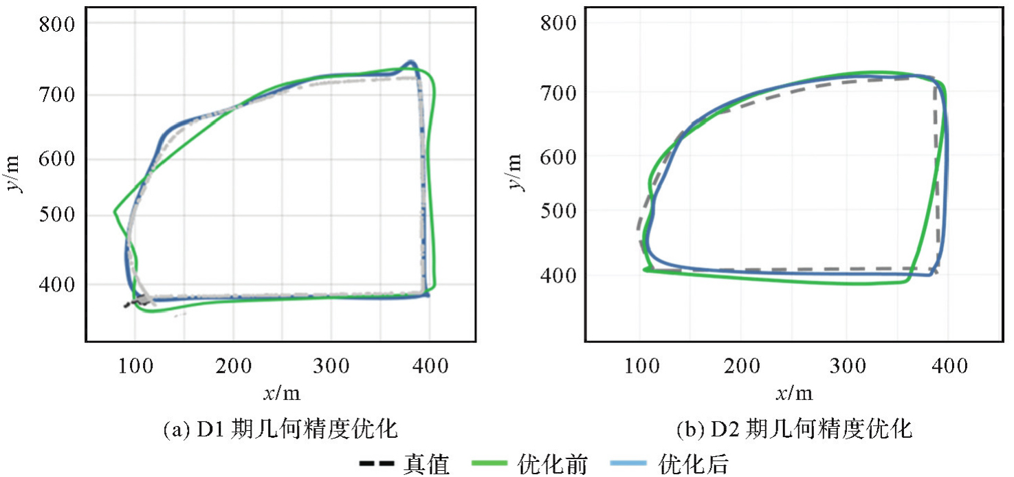
表4
两种方法的点云数量对比"
| 期 | ORB-SLAM2点云数量 | 本文方法点云数量 | 优化提升/(%) |
|---|---|---|---|
| D1 | 156 486 | 250 213 | 59.89 |
| D2 | 140 852 | 219 792 | 56.04 |
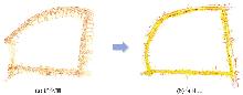
图6
D1期视觉点云质量优化前后对比"
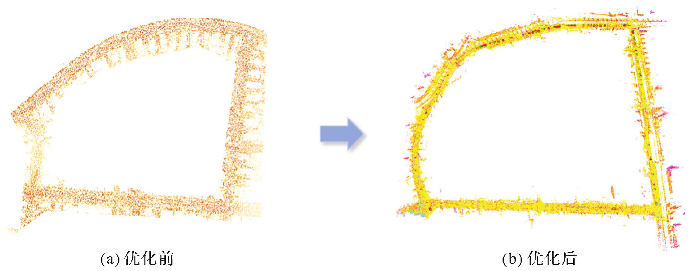
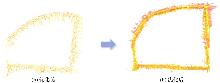
图7
D2期视觉点云质量优化前后对比"
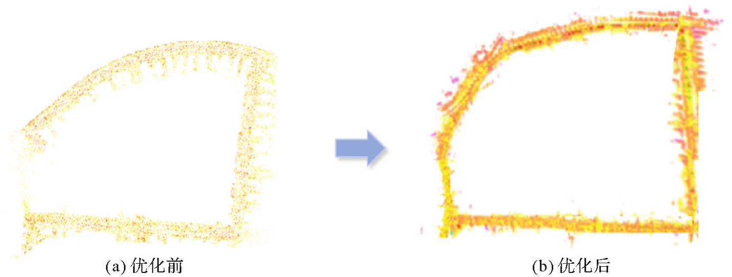
表5
仅语义优化的消融试验对比"
| 期 | DynaSLAM | 本文方法(仅语义优化) | ||||
|---|---|---|---|---|---|---|
| MAE/m | RMSE/m | 时间/s | MAE/m | RMSE/m | 时间/s | |
| D1 | 3.763 | 3.424 | 1029 | 2.082 | 2.201 | 798 |
| D2 | 3.913 | 3.664 | 1033 | 2.461 | 2.515 | 811 |
表6
仅激光点云优化的消融试验对比"
| 期 | MCL | 本文方法(仅激光点云优化) | ||||
|---|---|---|---|---|---|---|
| MAE/m | RMSE/m | 时间/s | MAE/m | RMSE/m | 时间/s | |
| D1 | 2.671 | 2.816 | 895 | 1.902 | 2.046 | 861 |
| D2 | 3.120 | 3.351 | 904 | 2.231 | 2.339 | 873 |
表7
仅GNSS优化的消融试验对比"
| 期 | MVSLAM | 本文方法(仅GNSS优化) | ||||
|---|---|---|---|---|---|---|
| MAE/m | RMSE/m | 时间/s | MAE/m | RMSE/m | 时间/s | |
| D1 | 2.912 | 3.061 | 813 | 2.013 | 2.101 | 795 |
| D2 | 3.645 | 3.816 | 821 | 2.307 | 2.384 | 801 |
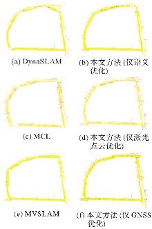
图8
D1期视觉点云质量优化消融试验对比"
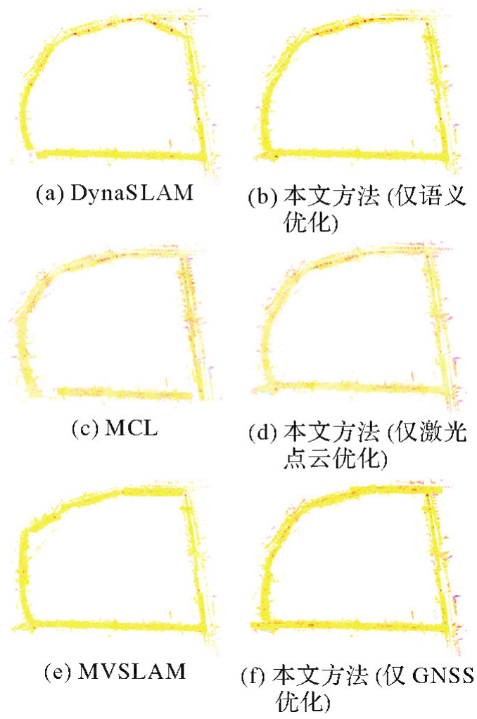
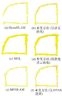
图9
D2期视觉点云质量优化消融试验对比"
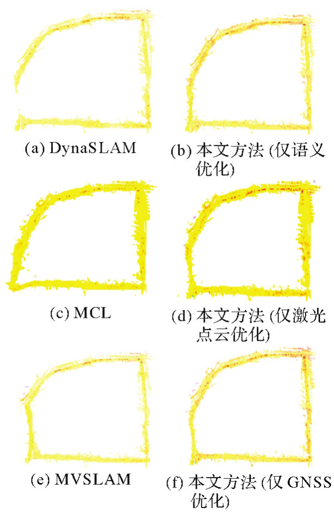
图10
D1期杆状物定位结果"
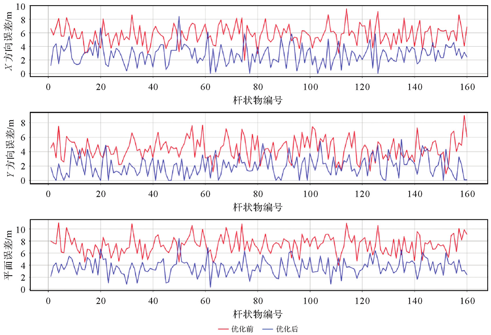
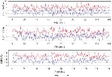
图11
D2期杆状物定位结果"
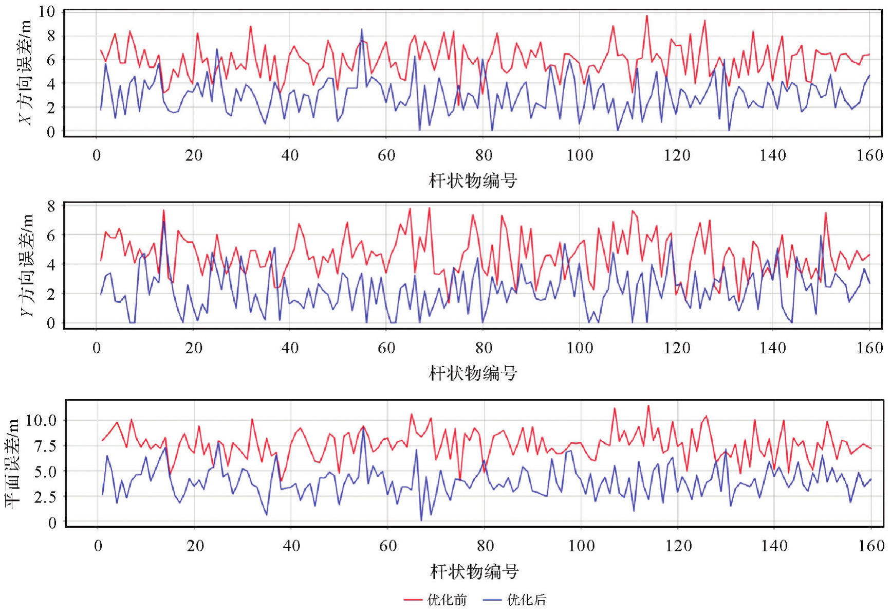
表8
道路杆状物平均定位误差"
| 统计指标 | D1 | D2 | ||||
|---|---|---|---|---|---|---|
| 优化前/m | 优化后/m | 优化提升/(%) | 优化前/m | 优化后/m | 优化提升/(%) | |
| X方向 | 5.834 | 2.628 | 54.95 | 6.044 | 2.821 | 53.32 |
| Y方向 | 4.357 | 2.015 | 53.75 | 4.533 | 2.257 | 50.22 |
| 平面 | 7.281 | 3.312 | 54.37 | 7.555 | 3.613 | 52.18 |
表9
道路杆状物匹配结果"
| 匹配指标 | 匹配总数 | 正确匹配数 | 匹配准确率/(%) | 匹配效率(单目标)/ms |
|---|---|---|---|---|
| 结果 | 161 | 153 | 94.8% | 12 |

图12
杆状物错误匹配案例"
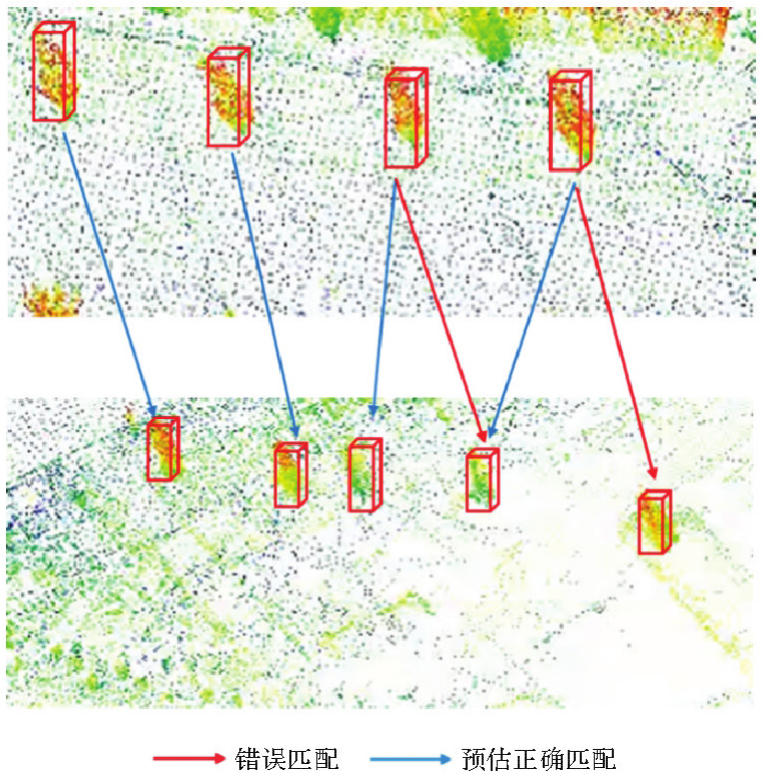
表10
道路杆状物变化检测结果"
| 变化检测类型 | 总数 | 精确率/(%) | 召回率/(%) |
|---|---|---|---|
| 新增 | 2 | 100 | 100 |
| 移除 | 1 | 100 | 100 |
图13
道路杆状物新增验证"
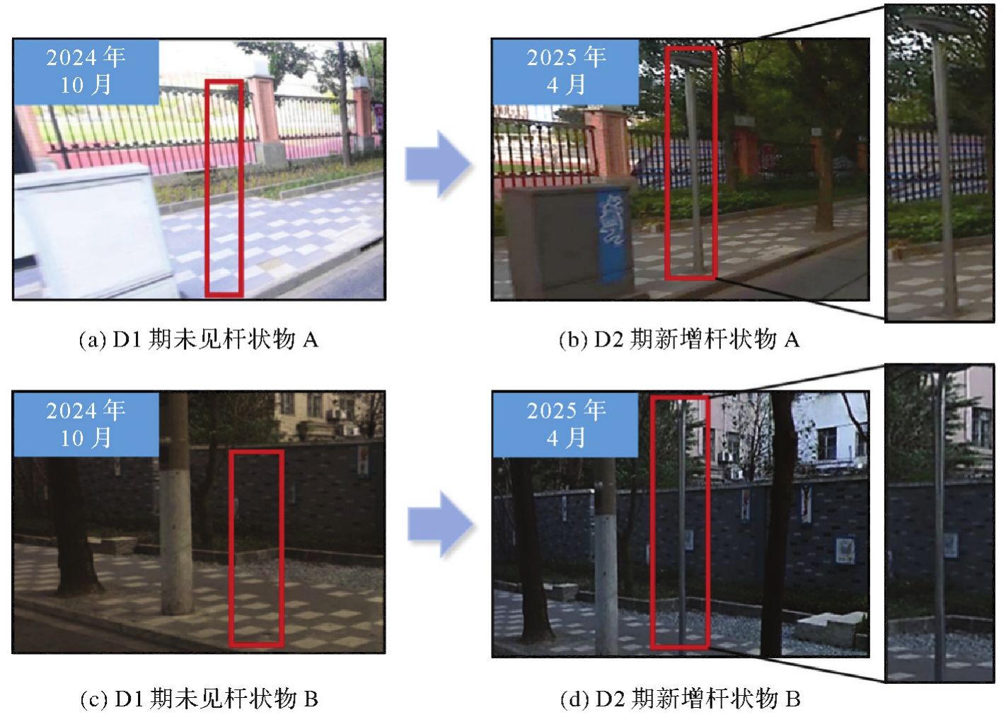
图14
道路杆状物移除验证"
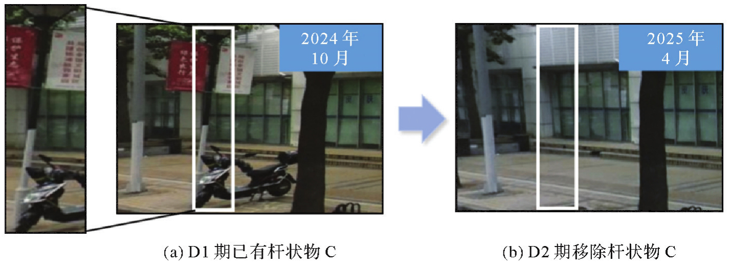
表11
道路杆状物人为变化检测结果"
| 变化检测类型 | 总数 | 精确率/(%) | 召回率/(%) |
|---|---|---|---|
| 新增 | 10 | 100 | 100 |
图15
道路杆状物模拟新增验证"
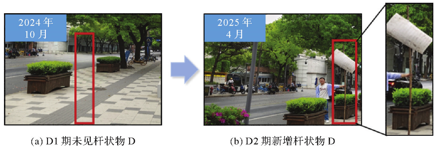
表12
地形图数据试验验证结果"
| 杆状物类别 | 真值数量 | 本文方法计算数量 |
|---|---|---|
| 路灯 | 137 | 138 |
| 标识牌 | 23 | 23 |
| 限高 | 1 | 1 |
| 总计 | 161 | 162 |
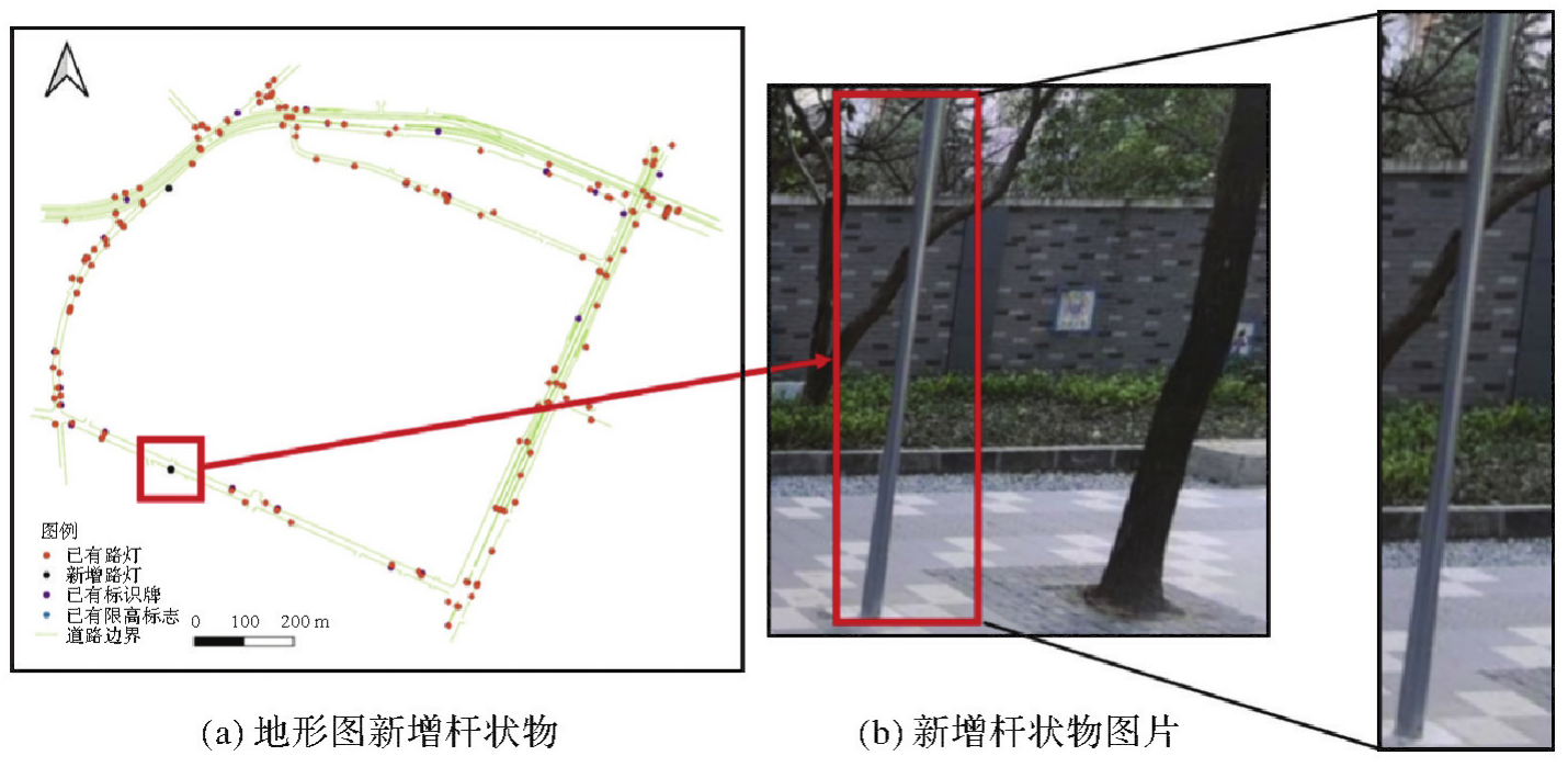
图16
地形图新增杆状物数据"
| [1] | 张敏, 王雁河, 孙周, 等. 交能融合应用场景与技术体系研究[J]. 综合智慧能源, 2025, 47(2): 13-28. |
| ZHANG Min, WANG Yanhe, SUN Zhou, et al. Research on application scenarios and technical system for transportation-energy integration[J]. Integrated Intelligent Energy, 2025, 47(2): 13-28. | |
| [2] | 杨蒙蒙, 江昆, 温拓朴, 等. 自动驾驶高精度地图众源更新技术现状与挑战[J]. 中国公路学报, 2023, 36(5): 244-259. |
| YANG Mengmeng, JIANG Kun, WEN Tuopu, et al. Review on status and challenges of crowdsourced updating of highly automated driving maps[J]. China Journal of Highway and Transport, 2023, 36(5): 244-259. | |
| [3] | XIAO Guiming, LEE Jaeyoung, JIANG Qianshan, et al. Safety improvements by intelligent connected vehicle technologies: a meta-analysis considering market penetration rates[J]. Accident Analysis and Prevention, 2021, 159: 106234. |
| [4] | LI Qingquan. Dynamic and precise engineering surveying[M]. Berlin: Springer, 2023. |
| [5] | FENG Jie, CHEN Hongbin, DENG Xianjun, et al. Confident information coverage hole prediction and repairing for healthcare big data collection in large-scale hybrid wireless sensor networks[J]. IEEE Internet of Things Journal, 2021, 8(23): 16801-16813. |
| [6] |
范红超, 孔格菲, 杨岸然. 众源地理信息研究现状与展望[J]. 测绘学报, 2022, 51(7): 1653-1668. DOI: .
doi: 10.11947/j.AGCS.2022.20220192 |
|
FAN Hongchao, KONG Gefei, YANG Anran. Current status and prospects of research for volunteered geographic information[J]. Acta Geodaetica et Cartographica Sinica, 2022, 51(7): 1653-1668. DOI: .
doi: 10.11947/j.AGCS.2022.20220192 |
|
| [7] | MORENO C, GONZÁLEZ A, OLAZAGOITIA J L, et al. The acquisition rate and soundness of a low-cost data acquisition system (LC-DAQ) for high frequency applications[J]. Sensors, 2020, 20(2): 524. |
| [8] | ADADI A. A survey on data-efficient algorithms in big data era[J]. Journal of Big Data, 2021, 8(1): 24. |
| [9] | 冉蓉, 徐兴华, 邱少华, 等. 基于深度卷积神经网络的裂纹检测方法综述[J]. 计算机工程与应用, 2021, 57(9): 23-35. |
| RAN Rong, XU Xinghua, QIU Shaohua, et al. Review of crack detection methods based on deep convolutional neural networks[J]. Computer Engineering and Applications, 2021, 57(9): 23-35. | |
| [10] | 邹云昊, 李和松, 聂婧, 等. 基于RAW数据的图像处理及应用[J]. 信号处理, 2025, 41(2): 224-240. |
| ZOU Yunhao, LI Hesong, NIE Jing, et al. Image processing and applications based on RAW sensor data[J]. Journal of Signal Processing, 2025, 41(2): 224-240. | |
| [11] | CHENG Jun, ZHANG Liyan, CHEN Qihong, et al. A review of visual SLAM methods for autonomous driving vehicles[J]. Engineering Applications of Artificial Intelligence, 2022, 114: 104992. |
| [12] | LIU Hong, PAN Shuguo, GAO Wang, et al. LiDAR-inertial real-time state estimator with rod-shaped and planar feature[J]. Remote Sensing, 2022, 14(16): 4031. |
| [13] | YU Xinyi, HE Weiqi, QIAN Xuecheng, et al. Real-time rail recognition based on 3D point clouds[J]. Measurement Science and Technology, 2022, 33(10): 105207. |
| [14] | 蔡怀宇, 杨朝乾, 崔子扬, 等. 图像引导和点云空间约束的公路洒落物检测定位方法[J]. 光电工程, 2024, 51(3): 230317. |
| CAI Huaiyu, YANG Zhaoqian, CUI Ziyang, et al. Image-guided and point cloud space-constrained method for detection and localization of abandoned objects on the road[J]. Opto-Electronic Engineering, 2024, 51(3): 230317. | |
| [15] | SAHILI A R, HASSAN S, SAKHRIEH S M, et al. A survey of visual SLAM methods[J]. IEEE Access, 2023, 11: 139643-139677. |
| [16] | CHEN Xinyu, YU Yantao. An unsupervised low-light image enhancement method for improving V-SLAM localization in uneven low-light construction sites[J]. Automation in Construction, 2024, 162: 105404. |
| [17] | PENG Hongrui, ZHAO Ziyu, WANG Liguan. A review of dynamic object filtering in SLAM based on 3D LiDAR[J]. Sensors, 2024, 24(2): 645. |
| [18] | THEODOROU C, VELISAVLJEVIC V, DYO V. Visual SLAM for dynamic environments based on object detection and optical flow for dynamic object removal[J]. Sensors, 2022, 22(19): 7553. |
| [19] | WANG Ke, ZHAO Guoliang, LU Jianbo. A deep analysis of visual SLAM methods for highly automated and autonomous vehicles in complex urban environment[J]. IEEE Transactions on Intelligent Transportation Systems, 2024, 25(9): 10524-10541. |
| [20] | LU Yifan, LI Quanhao, LIU Baoan, et al. Robust collaborative 3D object detection in presence of pose errors[C]//Proceedings of 2023 IEEE International Conference on Robotics and Automation (ICRA). London: IEEE, 2023: 4812-4818. |
| [21] | HOSAIN M T, ZAMAN A, ABIR M R, et al. Synchronizing object detection: applications, advancements and existing challenges[J]. IEEE Access, 2024, 12: 54129-54167. |
| [22] | YE Longjie, XIAO Wen, WENG Qihao. Supervoxel-based instance segmentation of pole-like facilities from mobile laser scanning data using pyramid cascaded fisher vector modeling[J]. IEEE Transactions on Geoscience and Remote Sensing, 2025, 63: 5701519. |
| [23] | LI Gang, YU Jian, HUANG Huilan, et al. Dynamic object removal and dense mapping for accurate visual SLAM in outdoor environments[J]. Measurement, 2025, 256: 118172. |
| [24] | LIU Wei, ANGUELOV D, ERHAN D, et al. SSD: single shot MultiBox detector[C]//Proceedings of 2016 Computer Vision-ECCV. Cham: Springer, 2016: 21-37. |
| [25] | LIM H, HWANG S, MYUNG H. ERASOR: egocentric ratio of pseudo occupancy-based dynamic object removal for static 3D point cloud map building[J]. IEEE Robotics and Automation Letters, 2021, 6(2): 2272-2279. |
| [26] | BESL P J, MCKAY N D. Method for registration of 3D shapes[J]. IEEE Transactions on Pattern Analysis and Machine Intelligence, 1992, 14(2): 239-256. |
| [27] | RODRIGUEZ O. Des lois geometriques qui regissent les desplacements d'un systeme solide dans l'espace et de la variation des coordonnees provenant de deplacements consideres independamment des causes qui peuvent les produire[J]. Vournalde Mathématiques Pureset Appliquées, 1840, 5: 380-440. |
| [28] | DEMMEL J, KAHAN W. Accurate singular values of bidiagonal matrices[J]. SIAM Journal on Scientific and Statistical Computing, 1990, 11(5): 873-912. |
| [29] | PANDE B, PADAMWAR K, BHATTACHARYA S, et al. A review of image annotation tools for object detection[C]//Proceedings of 2022 International Conference on Applied Artificial Intelligence and Computing (ICAAIC). Salem: IEEE, 2022: 976-982. |
| [30] | REDMON J, DIVVALA S, GIRSHICK R, et al. You only look once: unified, real-time object detection[C]//Proceedings of 2016 IEEE Conference on Computer Vision and Pattern Recognition (CVPR). Las Vegas: IEEE, 2016: 779-788. |
| [31] | YAO A C. Uniform hashing is optimal[J]. Journal of the ACM, 1985, 32(3): 687-693. |
| [32] | WANG Yanjun, LI Shaochun, WANG Mengjie, et al. A simple deep learning network for classification of 3D mobile LiDAR point clouds[J]. Journal of Geodesy and Geoinformation Science, 2021, 4(3): 49-59. |
| [33] | YANG Juntao, KANG Zhizhong, YANG Zhou. A robust model fitting-based method for transmission line extraction from airborne LiDAR point cloud data[J]. Journal of Geodesy and Geoinformation Science, 2021, 4(3): 60-71. |
| [34] | GENG Yuxin, ZHONG Ruofei, HUANG Yuqin, et al. Automatic extraction method of 3D feature guidelines for complex cultural relic surfaces based on point cloud[J]. Journal of Geodesy and Geoinformation Science, 2024, 7(1): 16-41. |
| [35] | YI Hao, LIU Bo, ZHAO Bin, et al. Small object detection algorithm based on improved YOLOv8 for remote sensing[J]. IEEE Journal of Selected Topics in Applied Earth Observations and Remote Sensing, 2024, 17: 1734-1747. |
| [36] | WILLMOTT C J, MATSUURA K. Advantages of the mean absolute error (MAE) over the root mean square error (RMSE) in assessing average model performance[J]. Climate Research, 2005, 30(1): 79-82. |
| [37] | BESCOS B, FÁCIL J M, CIVERA J, et al. DynaSLAM: tracking, mapping, and inpainting in dynamic scenes[J]. IEEE Robotics and Automation Letters, 2018, 3(4): 4076-4083. |
| [38] | CASELITZ T, STEDER B, RUHNKE M, et al. Monocular camera localization in 3D LiDAR maps[C]//Proceedings of 2016 IEEE/RSJ International Conference on Intelligent Robots and Systems (IROS). Daejeon: IEEE, 2016: 1926-1931. |
| [39] | CHU Tianxing, GUO Ningyan, BACKÉN S, et al. Monocular camera/IMU/GNSS integration for ground vehicle navigation in challenging GNSS environments[J]. Sensors, 2012, 12(3): 3162-3185. |
| [1] | 王红美, 王利花, 谭本华, 姜晓轶, 宋丽丽, 孙伟伟. 中国近海海表流场SAR高精度反演研究[J]. 测绘学报, 2026, 55(4): 588-603. |
| [2] | 吴岚昕, 彭江涛, 孙伟伟, 杨冰. 面向海岸带湿地高光谱遥感的欧拉映射与互补特征建模变化检测方法[J]. 测绘学报, 2026, 55(4): 618-631. |
| [3] | 彭代锋, 刘雪莲, 鲁梦飞, 管海燕. 基于多尺度跨模态特征融合的异源遥感影像洪水变化检测[J]. 测绘学报, 2026, 55(2): 328-343. |
| [4] | 张继贤, 顾海燕, 倪欢, 李海涛, 杨懿, 丁少鹏, 隋淞蔓. 遥感智能变化检测的深度学习方法:演变与发展趋势[J]. 测绘学报, 2025, 54(8): 1347-1370. |
| [5] | 王超, 陈天宇, 张同, AhmedTanvir, 纪立强, 谢涛, 杨佳俊, 王帅. 基于全局差分增强模块和平衡惩罚损失的多源光学遥感影像变化检测[J]. 测绘学报, 2025, 54(5): 873-887. |
| [6] | 杜钊锋, 李国鹏, 刘站科, 尚夏明, 康胜军, 王晓强. 国家重点沉降区域多监测手段综合分析[J]. 测绘学报, 2025, 54(3): 481-492. |
| [7] | 龚良雄, 李星华, 程远明, 赵兴友, 谢仁平, 王红根. 时空差异增强与自适应特征融合的轻量级遥感影像变化检测网络[J]. 测绘学报, 2025, 54(1): 136-153. |
| [8] | 鄢薪, 慎利, 潘俊杰, 戴延帅, 王继成, 郑晓莉, 李志林. 多尺度特征融合与空间优化的弱监督高分遥感建筑变化检测[J]. 测绘学报, 2024, 53(8): 1586-1597. |
| [9] | 宁晓刚, 张翰超, 张瑞倩. 遥感影像高可信智能不变检测技术框架与方法实践[J]. 测绘学报, 2024, 53(6): 1098-1112. |
| [10] | 顾海燕, 杨懿, 李海涛, 孙立坚, 丁少鹏, 刘世琦. 高分辨率遥感影像样本库动态构建与智能解译应用[J]. 测绘学报, 2024, 53(6): 1165-1179. |
| [11] | 彭代锋, 翟晨晨, 周顶蔚, 张永军, 管海燕, 臧玉府. 基于金字塔语义token全局信息增强的高分光学遥感影像变化检测[J]. 测绘学报, 2024, 53(6): 1195-1211. |
| [12] | 丁少鹏, 卢秀山, 刘如飞, 杨懿, 顾海燕, 李海涛. 联合目标特征引导与多重注意力的建筑物变化检测[J]. 测绘学报, 2024, 53(6): 1224-1235. |
| [13] | 庞世燕, 郝京京, 左志奇, 兰晶晶, 胡翔云. 融合密集连接和自注意力机制的高分辨率遥感影像变化检测方法[J]. 测绘学报, 2024, 53(12): 2244-2253. |
| [14] | 赵金奇, 李宇轩, 刘子蓉, 安庆, 宋时雨, 牛玉芬. 基于相似性衡量函数优化的SAR时空极化信息一体化洪涝变化检测方法[J]. 测绘学报, 2024, 53(12): 2375-2390. |
| [15] | 王彦坤, 樊红, 樊勇, 李晓明, 王伟玺, 郭仁忠. 一种“附近”空间关系增强的多源融合室内定位方法[J]. 测绘学报, 2024, 53(1): 118-125. |
| 阅读次数 | ||||||
|
全文 |
|
|||||
|
摘要 |
|
|||||