


测绘学报 ›› 2026, Vol. 55 ›› Issue (3): 404-414.doi: 10.11947/j.AGCS.2026.20250352
杨敏1( ), 马宏然1, 孔博1(), 刘鹏程2,3, 艾廷华1
收稿日期:2025-08-26
修回日期:2026-03-17
出版日期:2026-04-16
发布日期:2026-04-16
通讯作者:
孔博
E-mail:yangmin2003@whu.edu.cn;bokong@whu.edu.cn
作者简介:杨敏(1985—),男,教授,研究方向为地理空间深度学习与智能制图。E-mail:yangmin2003@whu.edu.cn
基金资助:
Min YANG1(), Hongran MA1, Bo KONG1(), Pengcheng LIU2,3, Tinghua AI1
Received:2025-08-26
Revised:2026-03-17
Online:2026-04-16
Published:2026-04-16
Contact:
Bo KONG
E-mail:yangmin2003@whu.edu.cn;bokong@whu.edu.cn
About author:YANG Min (1985—), male, professor, majors in geospatial deep learning and intelligent cartography. E-mail: yangmin2003@whu.edu.cn
Supported by:摘要:
矢量海岸线形态模式判别对海岸演化监测、海洋灾害预警、沿海区域规划等具有重要意义,也是海岸线制图表达的重要步骤。传统机器学习的判别方法依赖人工定义特征,同时需要大量标注样本进行长周期训练。为此,本文提出了海岸线通用几何特征学习与下游形态模式判别解耦的预训练模型方法。首先,通过运用坐标系重置和坐标归一化操作,将海岸线转化为适用于嵌入学习的Token序列。然后,设计基于随机遮掩的自监督坐标预测任务,结合基于Transformer的双向编码器表征模型构建海岸线通用几何特征学习的预训练模型。最后,利用标注数据集微调模型,迁移至海岸线形态模式判别任务。为了验证本文方法的有效性,基于开源海岸线数据构建了包含195 649条样本的预训练数据集和1000条样本的标注数据集。试验结果表明,本文方法在包含5种海岸线形态模式的判别任务中取得了90.72%的F1值,相较基于LSTM和1D-CNN的方法提升了7.31%~9.38%。
中图分类号:
杨敏, 马宏然, 孔博, 刘鹏程, 艾廷华. 基于预训练模型的矢量海岸线形态模式判别方法[J]. 测绘学报, 2026, 55(3): 404-414.
Min YANG, Hongran MA, Bo KONG, Pengcheng LIU, Tinghua AI. A pre-trained model-based method for discriminating morphological patterns of vector-based coastlines[J]. Acta Geodaetica et Cartographica Sinica, 2026, 55(3): 404-414.
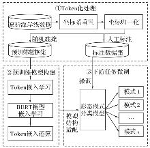
图1
基于预训练模型的矢量海岸线形态模式判别方法"
图2
矢量海岸线的Token化处理过程"
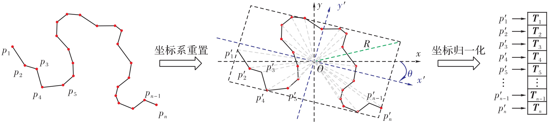
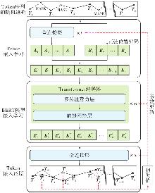
图3
面向海岸线几何特征学习的预训练模型"
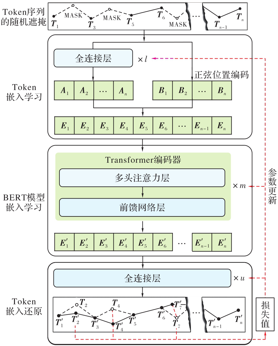
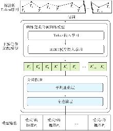
图4
适应海岸线形态模式判别的微调模块"
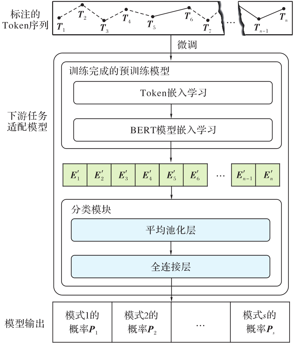
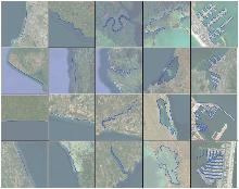
图5
不同形态模式的海岸线"
图6
预训练过程的模型损失变化情况"
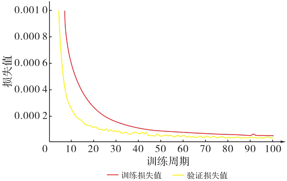
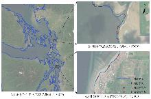
图7
预训练模型对遮掩节点的坐标预测结果"

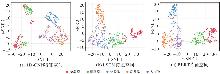
图8
3种方法学习获取的海岸线嵌入向量二维可视化结果"
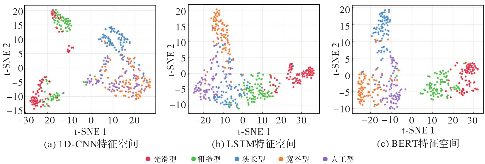
表1
3种方法针对测试集海岸线形态模式判别的精准率、召回率与F1值"
| 方法 | 精准率 | 召回率 | F1值 |
|---|---|---|---|
| 1D-CNN | 81.76 | 81.50 | 81.34 |
| LSTM | 83.81 | 83.25 | 83.41 |
| BERT | 90.83 | 90.75 | 90.72 |

图9
3种方法针对测试集海岸线形态模式判别的混淆矩阵"
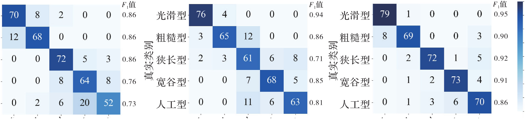
表2
海岸线形态模式判别的典型案例"
| 案例 | 海岸线形态 | 方法 | 判别概率 | ||||
|---|---|---|---|---|---|---|---|
| 光滑型 | 粗糙型 | 狭长型 | 宽谷型 | 人工型 | |||
| 案例1(狭长型) | 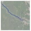 | 1D-CNN | 0.00 | 44.07 | 55.93 | 0.00 | 0.00 |
| LSTM | 2.19 | 63.31 | 34.38 | 0.00 | 0.12 | ||
| BERT | 0.00 | 13.24 | 86.76 | 0.00 | 0.00 | ||
| 案例2(宽谷型) | 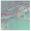 | 1D-CNN | 0.00 | 57.04 | 0.22 | 41.05 | 1.69 |
| LSTM | 2.48 | 33.19 | 1.30 | 61.05 | 1.98 | ||
| BERT | 0.00 | 17.00 | 0.00 | 79.13 | 3.87 | ||
| 案例3(人工型) | 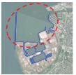 | 1D-CNN | 0.00 | 0.00 | 10.27 | 56.09 | 33.64 |
| LSTM | 0.00 | 2.20 | 0.30 | 22.14 | 75.36 | ||
| BERT | 0.00 | 1.66 | 0.17 | 0.00 | 98.17 | ||
表3
本文方法的海岸线形态模式误判案例"
| 案例 | 海岸线形态 | 方法 | 判别概率 | ||||
|---|---|---|---|---|---|---|---|
| 光滑型 | 粗糙型 | 狭长型 | 宽谷型 | 人工型 | |||
| 案例1(狭长型) | 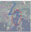 | 1D-CNN | 0.00 | 9.46 | 15.72 | 68.31 | 6.51 |
| LSTM | 0.00 | 7.22 | 28.25 | 64.53 | 0.00 | ||
| BERT | 0.00 | 16.34 | 35.92 | 47.74 | 0.00 | ||
| 案例2(人工型) | 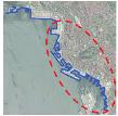 | 1D-CNN | 3.21 | 73.13 | 0.25 | 10.40 | 13.01 |
| LSTM | 0.79 | 63.56 | 2.06 | 20.93 | 12.66 | ||
| BERT | 0.00 | 84.04 | 0.00 | 0.00 | 15.96 | ||
| [1] | 骆永明. 中国海岸带可持续发展中的生态环境问题与海岸科学发展[J]. 中国科学院院刊, 2016, 31(10): 1133-1142. |
| LUO Yongming. Sustainability associated coastal eco-environmental problems and coastal science development in China[J]. Bulletin of the Chinese Academy of Sciences, 2016, 31(10): 1133-1142. | |
| [2] | JOHNSON D W. Shore processes and shoreline development[M]. New York: Wiley, 1919: 159-190. |
| [3] | 修淳, 霍素霞, 姚海燕, 等. 注重新形势下自然岸线管控的海岸线分类体系探讨[J]. 地理科学, 2022, 42(2): 333-342. |
| XIU Chun, HUO Suxia, YAO Haiyan, et al. Coastline classification for strictly controlling natural coastline in the new era[J]. Scientia Geographica Sinica, 2022, 42(2): 333-342. | |
| [4] | 贾建军, 蔡廷禄, 刘毅飞, 等. 考虑人类活动的海岸线分类体系:近期浙江省海岸线调查的实践与思考[J]. 海洋科学, 2019, 43(10): 13-23. |
| JIA Jianjun, CAI Tinglu, LIU Yifei, et al. A classification of coastline considering the impacts of human activities: remarks on latest practices on coastline survey in Zhejiang province[J]. Marine Sciences, 2019, 43(10): 13-23. | |
| [5] | AI Tinghua, ZHOU Qi, ZHANG Xiang, et al. A simplification of ria coastline with geomorphologic characteristics preserved[J]. Marine Geodesy, 2014, 37(2): 167-186. |
| [6] |
杜佳威, 武芳, 李靖涵, 等. 一种河口湾海岸线渐进化简方法[J]. 测绘学报, 2018, 47(4): 547-556. DOI: .
doi: 10.11947/j.AGCS.2018.20170440 |
|
DU Jiawei, WU Fang, LI Jinghan, et al. A progressive simplification method for the estuary coastline[J]. Acta Geodaetica et Cartographica Sinica, 2018, 47(4): 547-556. DOI: .
doi: 10.11947/j.AGCS.2018.20170440 |
|
| [7] | 刘鹏程, 杨琴. 贝叶斯模型下面向地图表达的海岸线分段模型[J]. 计算机工程与应用, 2016, 52(22): 174-179. |
| LIU Pengcheng, YANG Qin. Coastline segment model research for map generalization based on Bayesian method[J]. Computer Engineering and Applications, 2016, 52(22): 174-179. | |
| [8] | MANDELBROT B. How long is the coast of Britain statistical self-similarity and fractional dimension[J]. Science, 1967, 156(3775): 636-638. |
| [9] |
艾廷华. 深度学习赋能地图制图的若干思考[J]. 测绘学报, 2021, 50(9): 1170-1182. DOI: .
doi: 10.11947/j.AGCS.2021.20210091 |
|
AI Tinghua. Some thoughts on deep learning enabling cartography[J]. Acta Geodaetica et Cartograpgica Sinica, 2021, 50(9): 1170-1182. DOI: .
doi: 10.11947/j.AGCS.2021.20210091 |
|
| [10] |
刘鹏程, 黄欣, 马宏然, 等. 建筑物多边形高精度识别的傅里叶形状描述子神经网络方法[J]. 测绘学报, 2022, 51(9): 1969-1976. DOI: .
doi: 10.11947/j.AGCS.2022.20210730 |
|
LIU Pengcheng, HUANG Xin, MA Hongran, et al. Fourier descriptor-based neural network method for high-precision shape recognition of building polygon[J]. Acta Geodaetica et Cartograpgica Sinica, 2022, 51(9): 1969-1976. DOI: .
doi: 10.11947/j.AGCS.2022.20210730 |
|
| [11] |
晏雄锋, 袁拓, 杨敏, 等. 建筑物形状特征分析表达与自适应化简方法[J]. 测绘学报, 2022, 51(2): 269-278. DOI: .
doi: 10.11947/j.AGCS.2022.20210302 |
|
YAN Xiongfeng, YUAN Tuo, YANG Min, et al. An adaptive building simplification approach based on shape analysis and representation[J]. Acta Geodaetica et Cartograpgica Sinica, 2022, 51(2): 269-278. DOI: .
doi: 10.11947/j.AGCS.2022.20210302 |
|
| [12] |
于洋洋, 贺康杰, 武芳, 等. 面状居民地形状分类的图卷积神经网络方法[J]. 测绘学报, 2022, 51(11): 2390-2402. DOI: .
doi: 10.11947/j.AGCS.2022.20210134 |
|
YU Yangyang, HE Kangjie, WU Fang, et al. Graph convolution neural network method for shape classification of areal settlements[J]. Acta Geodaetica et Cartograpgica Sinica, 2022, 51(11): 2390-2402. DOI: .
doi: 10.11947/j.AGCS.2022.20210134 |
|
| [13] |
张付兵, 孙群, 马京振, 等. 融合全局和局部特征的建筑物形状智能分类方法[J]. 测绘学报, 2024, 53(9): 1842-1852. DOI: .
doi: 10.11947/j.AGCS.2024.20240040 |
|
ZHANG Fubing, SUN Qun, MA Jingzheng, et al. An intelligent classification method for building shape based on fusion of global and local features[J]. Acta Geodaetica et Cartograpgica Sinica, 2024, 53(9): 1842-1852. DOI: .
doi: 10.11947/j.AGCS.2024.20240040 |
|
| [14] | YANG Min, JIANG Chenjun, YAN Xiongfeng, et al. Detecting interchanges in road networks using a graph convolutional network approach[J]. International Journal of Geographical Information Science, 2022, 36(6): 1119-1139. |
| [15] |
何海威, 钱海忠, 谢丽敏, 等. 立交桥识别的CNN卷积神经网络法[J]. 测绘学报, 2018, 47(3): 385-395. DOI: .
doi: 10.11947/j.AGCS.2018.20170265 |
|
HE Haiwei, QIAN Haizhong, XIE Limin, et al. Interchange recognition method based on CNN[J]. Acta Geodaetica et Cartograpgica Sinica, 2018, 47(3): 385-395. DOI: .
doi: 10.11947/j.AGCS.2018.20170265 |
|
| [16] | YU Huafei, AI Tinghua, Yang Min, et al. A recognition method for drainage patterns using a graph convolutional network[J]. International Journal of Applied Earth Observation and Geoinformation, 2022, 107: 102696. |
| [17] |
余华飞, 邱天奇, 周哲, 等. 图Transformer支持下的河网模式识别[J]. 测绘学报, 2024, 53(11): 2075-2085. DOI: .
doi: 10.11947/j.AGCS.2024.20230582 |
|
YU Huafei, QIU Tianqi, ZHOU Zhe, et al. Drainage pattern recognition supported by graph Transformer[J]. Acta Geodaetica et Cartograpgica Sinica, 2024, 53(11): 2075-2085. DOI: .
doi: 10.11947/j.AGCS.2024.20230582 |
|
| [18] |
孔博, 艾廷华, 杨敏, 等. 等高线形态知识与图神经网络联合作用下的黄土地貌类型识别[J]. 测绘学报, 2024, 53(6): 1154-1164. DOI: .
doi: 10.11947/j.AGCS.2024.20230445 |
|
KONG Bo, AI Tinghua, YANG Min, et al. Identification of loess landform types jointly affected by contour morphological knowledge and the graph neural network[J]. Acta Geodaeticaet Cartograpgica Sinica, 2024, 53(6): 1154-1164. DOI: .
doi: 10.11947/j.AGCS.2024.20230445 |
|
| [19] | GAO Aji, AI Tinghua, YU Huafei, et al. A vector-based coastline shape classification approach using sequential deep learning model[J]. International Journal of Applied Earth Observation and Geoinformation, 2024, 129: 103810. |
| [20] |
杨敏, 陈果, 李连营, 等. 序列卷积神经网络支持下线状地图目标的分段方法[J]. 测绘学报, 2023, 52(1): 108-116. DOI: .
doi: 10.11947/j.AGCS.2023.20210317 |
|
YANG Min, CHEN Guo, LI Lianying, et al. Segmentation of linear map objects using sequential convolutional neural network[J]. Acta Geodaetica et Cartograpgica Sinica, 2023, 52(1): 108-116. DOI: .
doi: 10.11947/j.AGCS.2023.20210317 |
|
| [21] | PATWARDHAN N, MARRONE S, SANSONE C. Transformers in the real world: a survey on NLP applications[J]. Information, 2023, 14(4): 242. |
| [22] | SCHMIRLER R, HEINZINGER M, ROST B. Fine-tuning protein language models boosts predictions across diverse tasks[J]. Nature Communications, 2024, 15(1): 7407. |
| [23] | DEVLIN J, CHANG M-W, LEE K, et al. Bert: pre-training of deep bidirectional transformers for language understanding[C]//Proceedings of 2019 Conference of the North American Chapter of the Association for Computational Linguistics: Human Language Technologies. Minnesota: Association for Computational Linguistics, 2019: 4171-4186. |
| [24] | YAN Xiongfeng, YANG Min, AI Tinghua. Deep learning in automatic map generalization: achievements and challenges[J]. Geo-spatial Information Science, 2025, 28(6): 2905-2926. |
| [25] | MIKOLOV T, SUTSKEVER I, CHEN K, et al. Distributed representations of words and phrases and their compositionality[C]//Proceedings of the 27th Annual Conference on Neural Information Processing Systems. Red Hook: Curran Associates Inc., 2013: 3111-3119. |
| [26] | VASWANI A, SHAZEER N, PARMAR N, et al. Attention is all you need[C]//Proceedings of the 31st International Conference on Neural Information Processing Systems. Red Hook: Curran Associates Inc., 2017: 6000-6010. |
| [27] | LECUN Y, BOTTOU L, BENGIO Y, et al. Gradient-based learning applied to document recognition[J]. Proceedings of the IEEE, 1998, 86(11): 2278-2324. |
| [28] | HOCHREITER S, SCHMIDHUBER J. Long short-term memory[J]. Neural Computation, 1997, 9(8): 1735-1780. |
| [29] | VAN DER MAATEN L. Accelerating t-SNE using tree-based algorithms[J]. The Journal of Machine Learning Research, 2014, 15(1): 3221-3245. |
| [30] | HUBERT L, ARABIE P. Comparing partitions[J]. Journal of Classification, 1985, 2(1): 193-218. |
| [31] | VINH N X, EPPS J, BAILEY J. Information theoretic measures for clusterings comparison: variants, properties, normalization and correction for chance[J]. Journal of Machine Learning Research, 2010(11): 2837-2854. |
| [32] | STEINLEY D. Properties of the hubert-arabie adjusted rand index[J]. Psychological Methods, 2004, 9(3): 386-396. |
| [33] | 刘鹏程, 艾廷华, 杨敏. 基于傅里叶级数的等高线网络渐进式传输模型[J]. 测绘学报, 2012, 41(2): 284-290. |
| LIU Pengcheng, AI Tinghua, YANG Min. The internet progressive transmission model for contour based on Fourier series[J]. Acta Geodaetica et Cartographica Sinica, 2012, 41(2): 284-290. |
| [1] | 吴明光, 成梓铭. 顾及使用场景的绿色地图颜色生成方法研究[J]. 测绘学报, 2026, 55(3): 390-403. |
| [2] | 禹文豪, 曾子怡, 张一帆, 钱海忠. 融合欧氏空间邻近与拓扑邻接信息预训练模型的路网网格模式[J]. 测绘学报, 2026, 55(3): 415-424. |
| [3] | 禄小敏, 张志义, 闫浩文, 何毅, 苏小宁. 融合深度图信息最大化和多层感知机的建筑物群组模式识别方法[J]. 测绘学报, 2026, 55(3): 425-438. |
| [4] | 成晓强, 赵家威, 刘鹏程. 基于距离-相似性隐喻的空间交互可视化[J]. 测绘学报, 2026, 55(3): 536-547. |
| [5] | 王泽矫, 向隆刚, 王猛, 王兴娟, 刘清. 融合层级特征与多样化注意力的道路面与中心线协同提取网络[J]. 测绘学报, 2026, 55(3): 548-563. |
| [6] | 徐智邦. 实体城市的多层次边界识别、模式分析与扩张模拟[J]. 测绘学报, 2026, 55(3): 566-566. |
| [7] | 冉耘博, 杨雪, 周文豪, 吴承恩, 周宝定, 唐炉亮, 李清泉. 多维偏好增强型对抗深度强化学习驱动的行人路径规划[J]. 测绘学报, 2026, 55(2): 191-205. |
| [8] | 王立增, 程诗奋, 杨一涛, 王培晓, 陆锋. 局部-全局联合感知的时空自适应交通集成预测方法[J]. 测绘学报, 2026, 55(2): 206-221. |
| [9] | 王少华, 梁浩健, 苏澄, 徐大川, 周亮, 秦昆. 耦合时空大数据和人工智能的城市设施配置优化研究进展与展望[J]. 测绘学报, 2026, 55(2): 222-235. |
| [10] | 付晓, 朱司蕊, 厉旭东, 闾国年. 面向长距离通勤场景的城市垂直起降场布局优化方法[J]. 测绘学报, 2026, 55(2): 236-248. |
| [11] | 郭军豪, 吴明治, 王培晓, 张恒才. 一种面向定点稀疏轨迹的密度聚类停留点识别方法[J]. 测绘学报, 2026, 55(2): 249-260. |
| [12] | 李冠男. 道路实景三维模型自动构建方法[J]. 测绘学报, 2026, 55(2): 378-378. |
| [13] | 刘鹏程, 成晓强, 肖天元, 杨敏, 艾廷华. 一种面向地图综合建筑多边形化简的Transformer模型[J]. 测绘学报, 2026, 55(1): 124-137. |
| [14] | 贺彪, 林浩嘉, 郭仁忠, 蒯希, 马丁, 张琛. 基于视觉感知的三维空间相似关系量化计算[J]. 测绘学报, 2026, 55(1): 138-153. |
| [15] | 李维炼, 冉晴晴, 党沛, 朱军, 朱庆, 张恒. 耦合LLMs-KG的地下车站设施洪水脆弱性级联效应分析方法[J]. 测绘学报, 2026, 55(1): 154-168. |
| 阅读次数 | ||||||
|
全文 |
|
|||||
|
摘要 |
|
|||||