


测绘学报 ›› 2026, Vol. 55 ›› Issue (2): 236-248.doi: 10.11947/j.AGCS.2026.20250434
付晓1,2,3( ), 朱司蕊1,2,3, 厉旭东4, 闾国年1,2,3()
收稿日期:2025-10-14
修回日期:2026-01-22
出版日期:2026-03-13
发布日期:2026-03-13
通讯作者:
闾国年
E-mail:fuxiao@njnu.edu.cn;gnlu@njnu.edu.cn
作者简介:付晓(1988—),女,博士,教授,研究方向为交通地理与智能交通。 E-mail:fuxiao@njnu.edu.cn
基金资助:
Xiao FU1,2,3(), Sirui ZHU1,2,3, Xudong LI4, Guonian LÜ1,2,3()
Received:2025-10-14
Revised:2026-01-22
Online:2026-03-13
Published:2026-03-13
Contact:
Guonian Lü
E-mail:fuxiao@njnu.edu.cn;gnlu@njnu.edu.cn
About author:FU Xiao (1988—), female, PhD, professor, majors in transport geography and intelligent transport. E-mail: fuxiao@njnu.edu.cn
Supported by:摘要:
城市空中交通为居民出行提供了新兴的交通选择,垂直起降场等关键基础设施的选址与空间布局将直接影响未来城市居民的出行模式与行为特征。聚焦城市居民的长距离通勤场景,本文基于真实的通勤需求数据,分析了垂直起降场的合理布局。本文构建了一个双层规划模型,模拟垂直起降场的选址与居民出行选择之间的互动机制,旨在寻求能够最小化通勤者单程通勤时间、提升高峰期地面通勤关键道路运行效率的选址方案。在上层,将站点选址构建为一个多目标优化模型,以候选站点的组合为决策变量,采用多目标遗传算法求解;在下层,通过多智能体交通仿真模拟典型通勤者的活动-出行链,评估布局方案对通勤效率的综合影响。以南京市长距离通勤场景为案例,试验结果表明,本文方法能有效提升长距离通勤效率,使整体通勤时间缩短约5%。本文为未来城市多模式交通的规划与管理提供了理论依据与支持。
中图分类号:
付晓, 朱司蕊, 厉旭东, 闾国年. 面向长距离通勤场景的城市垂直起降场布局优化方法[J]. 测绘学报, 2026, 55(2): 236-248.
Xiao FU, Sirui ZHU, Xudong LI, Guonian LÜ. An optimization method for the layout of urban vertiports in long-distance commuting scenarios[J]. Acta Geodaetica et Cartographica Sinica, 2026, 55(2): 236-248.
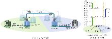
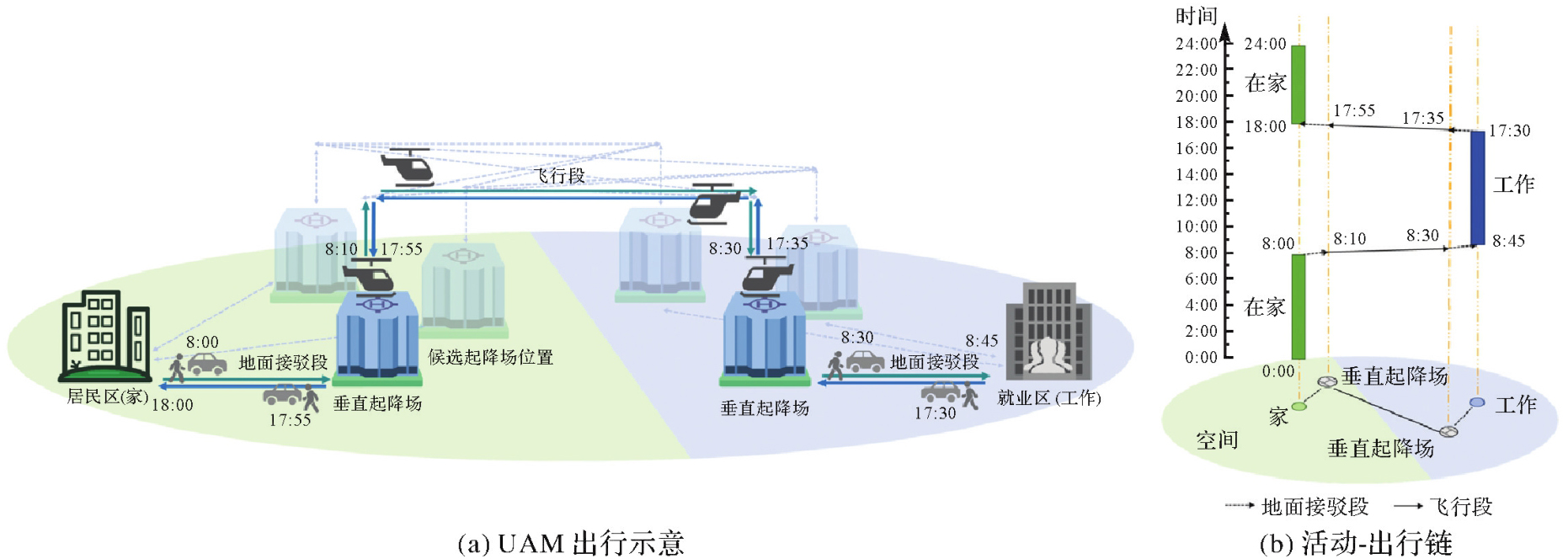
图1
UAM长距离通勤出行"
"
| 算法:基于通勤起讫点覆盖的k-medoids聚类算法 |
| 输入:起讫点集X={Oi,Di|(Oi,Di)∈D},中心间距限制dmin,dmax,聚类中心覆盖半径R,覆盖率阈值θ |
| 输出:起讫点对覆盖率γ(C),聚类结果 |
| K←1 |
| repeat |
| K←K+1,随机初始化K个聚类中心,要求任意两中心间距∈[dmin,dmax] |
| repeat |
| foreach起讫点xi∈X do将xi分配到最近中心cj |
foreach簇Sj do候选中心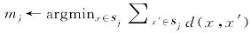 |
| if mj与其他候选中心距离∈[dmin,dmax] |
| then cj←mj |
| else选择满足约束的次优候选中心,若无满足条件的点则保持不变 |
| until所有中心收敛 |
| until γ(C)≥θ |
| 返回起讫点对覆盖率γ(C)、聚类结果 |
图2
智能体活动-出行计划的仿真过程"
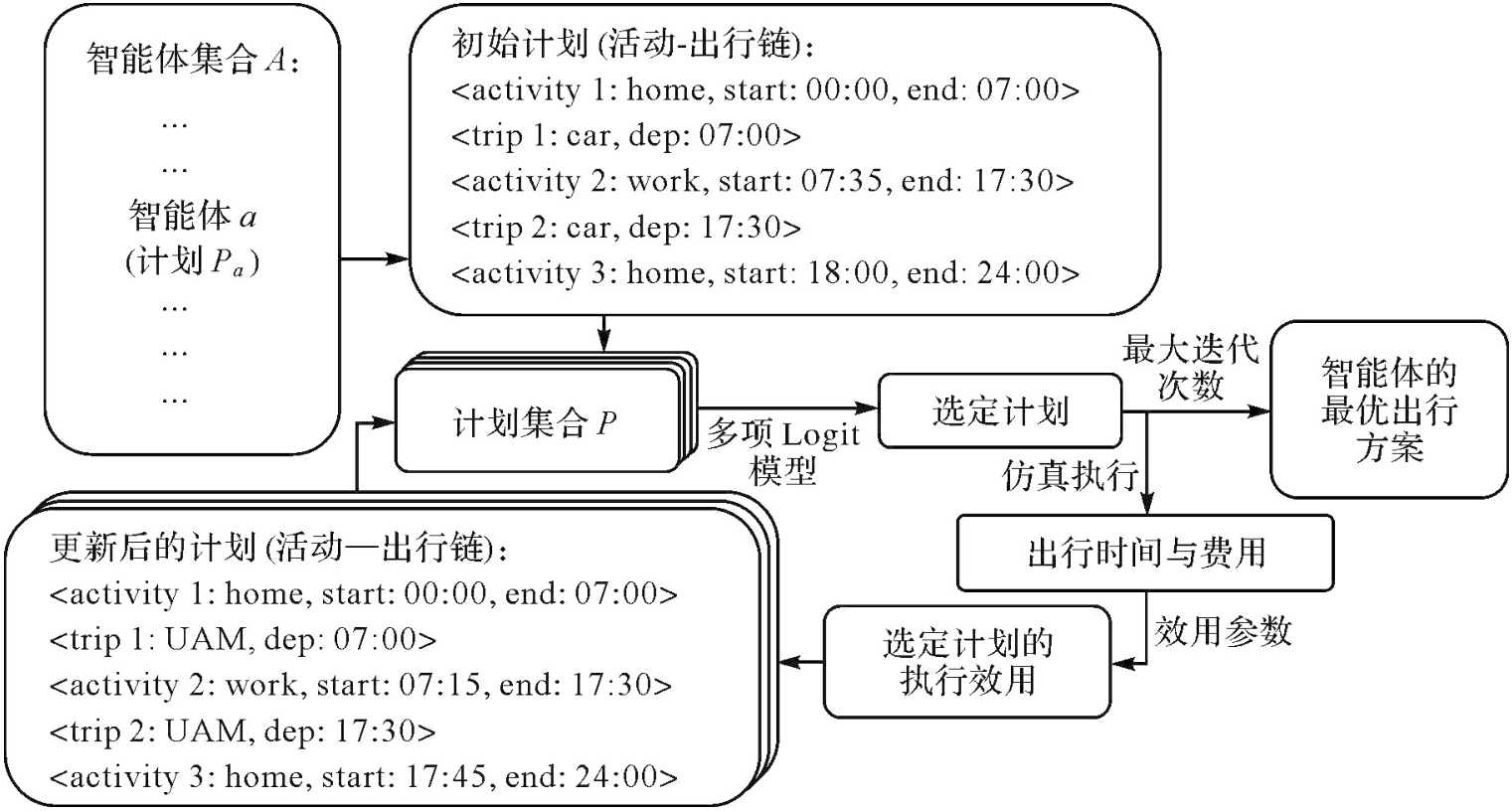
图3
基于双层规划的UAM通勤站点选址求解流程"
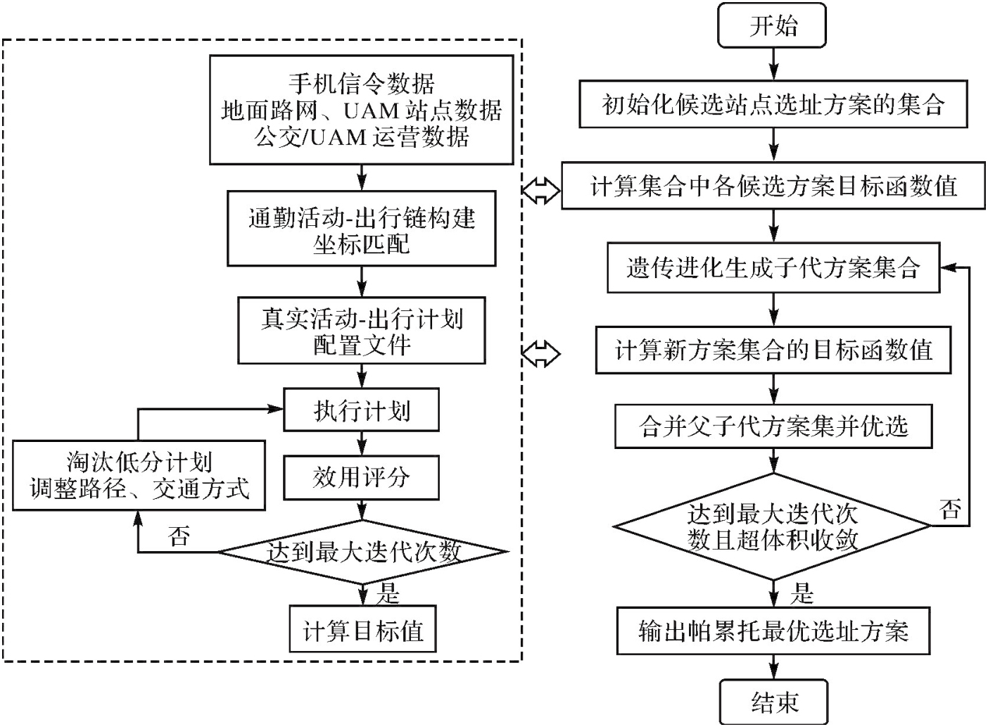
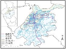
图4
试验区域"
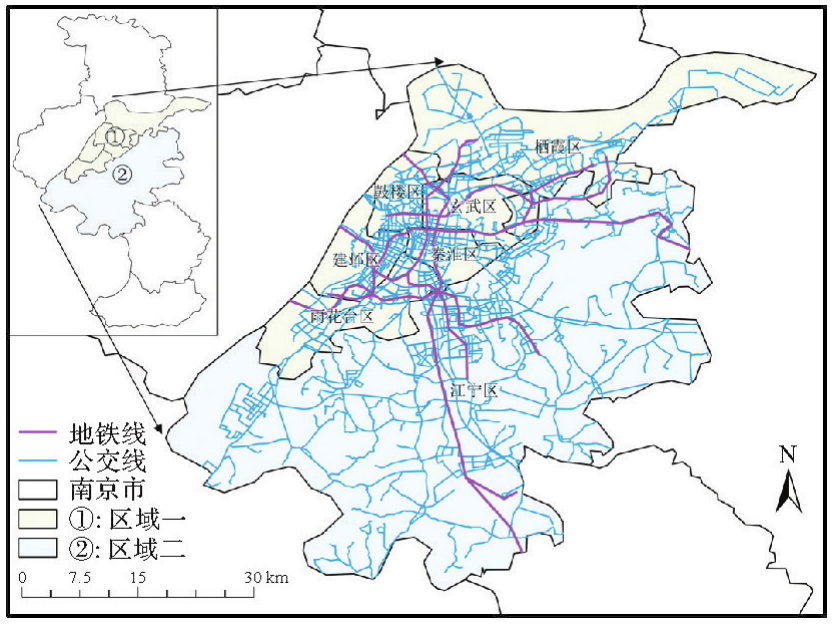
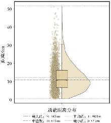
图5
通勤距离统计"
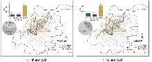
图6
通勤模式统计"
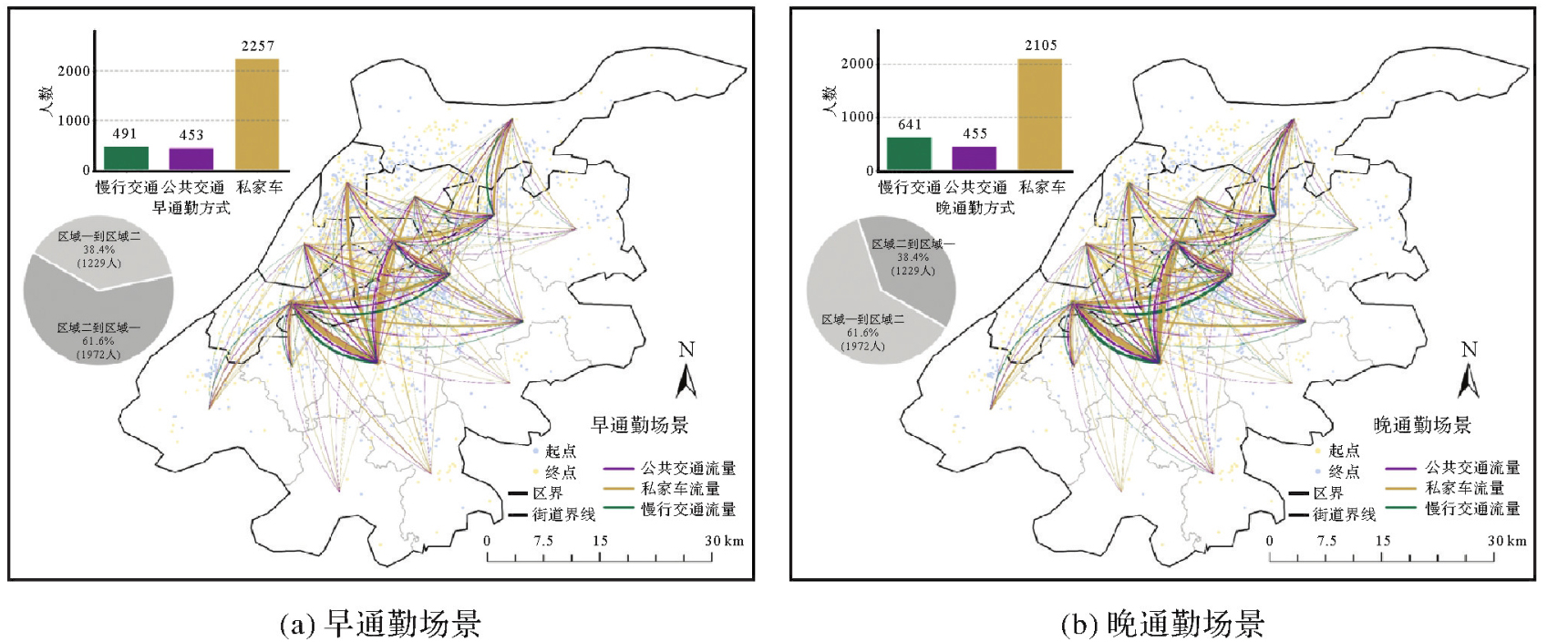
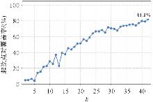
图7
聚类过程"
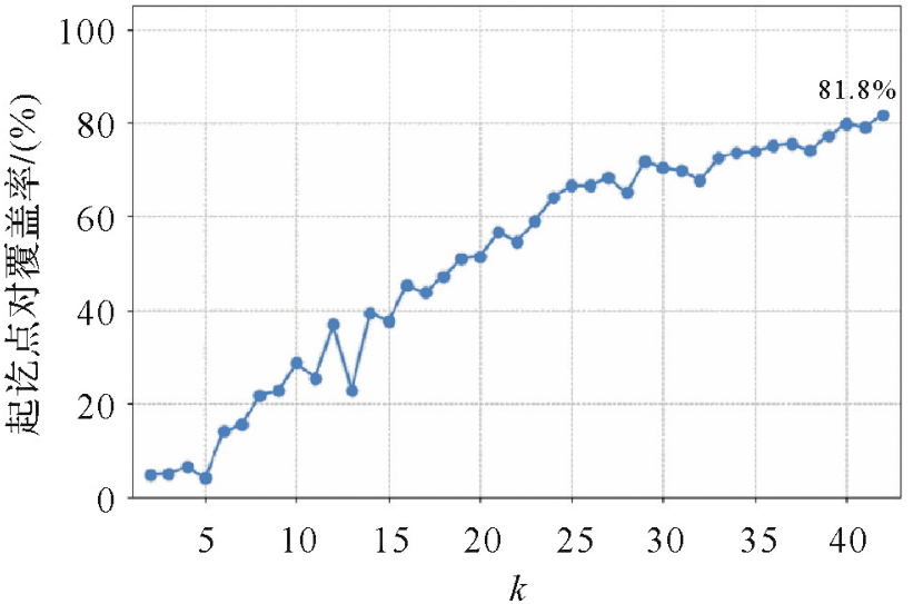
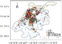
图8
候选起降场空间分布"
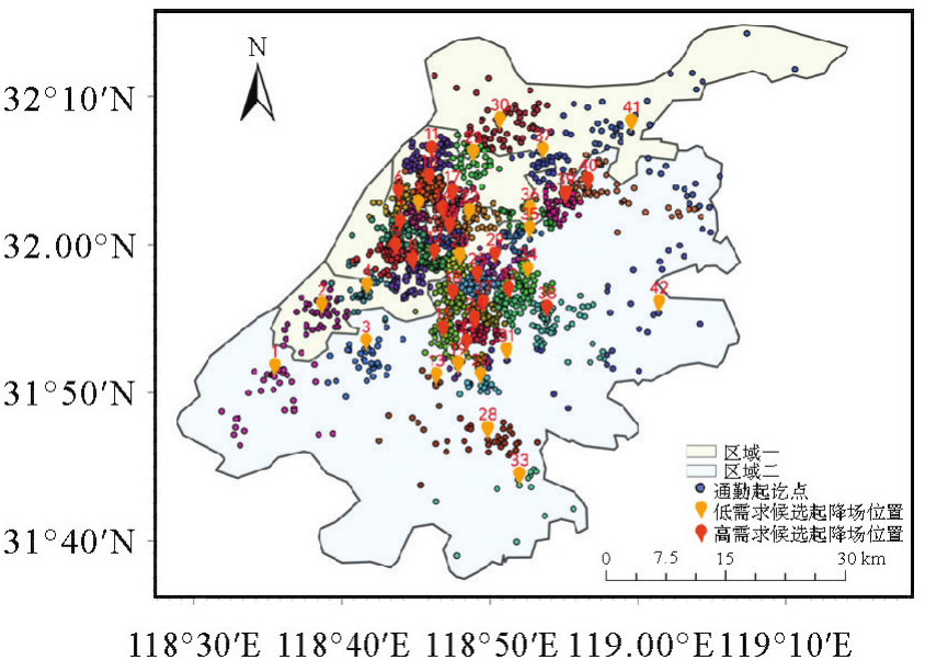
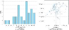
图9
聚类的稳健性检验"
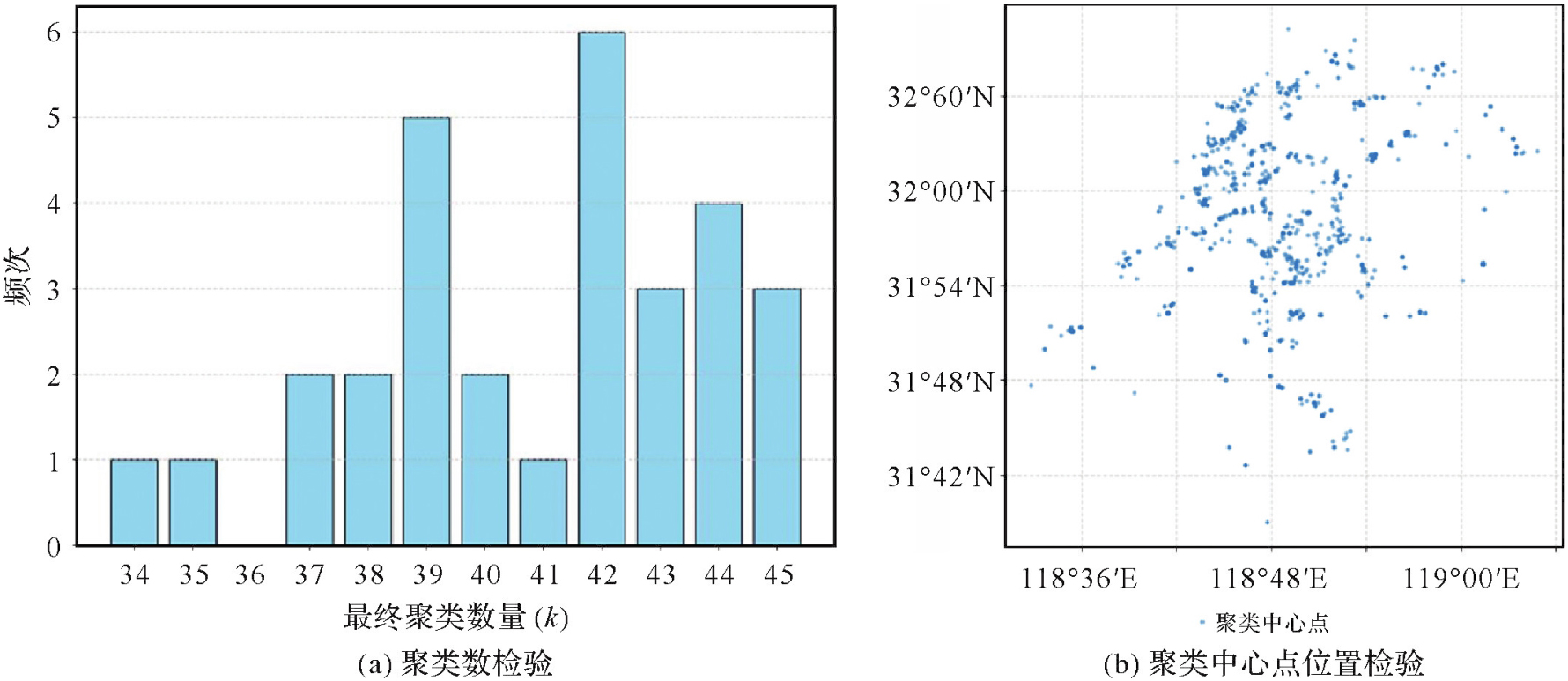
表1
效用参数取值"
| 出行方式 | 出行的时间边际效用/h | 单位距离货币成本/(元/km) |
|---|---|---|
| 私家车 | -6 | -2 |
| 公共交通 | -1.2 | -0.2 |
| 慢行交通 | -3.6 | 0 |
| UAM | -18 | -12 |
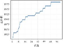
图10
超体积指标收敛曲线"
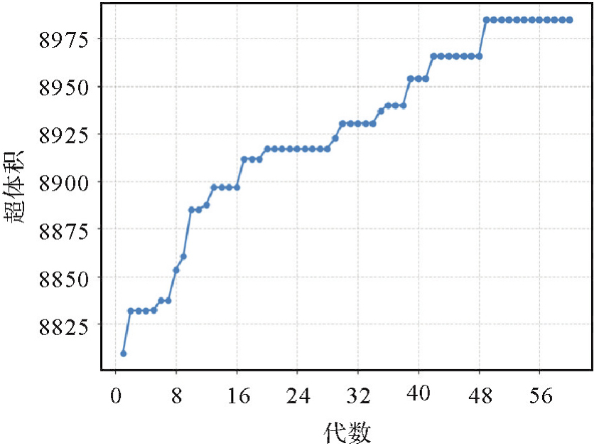
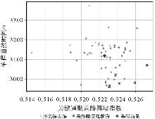
图11
帕累托前沿"
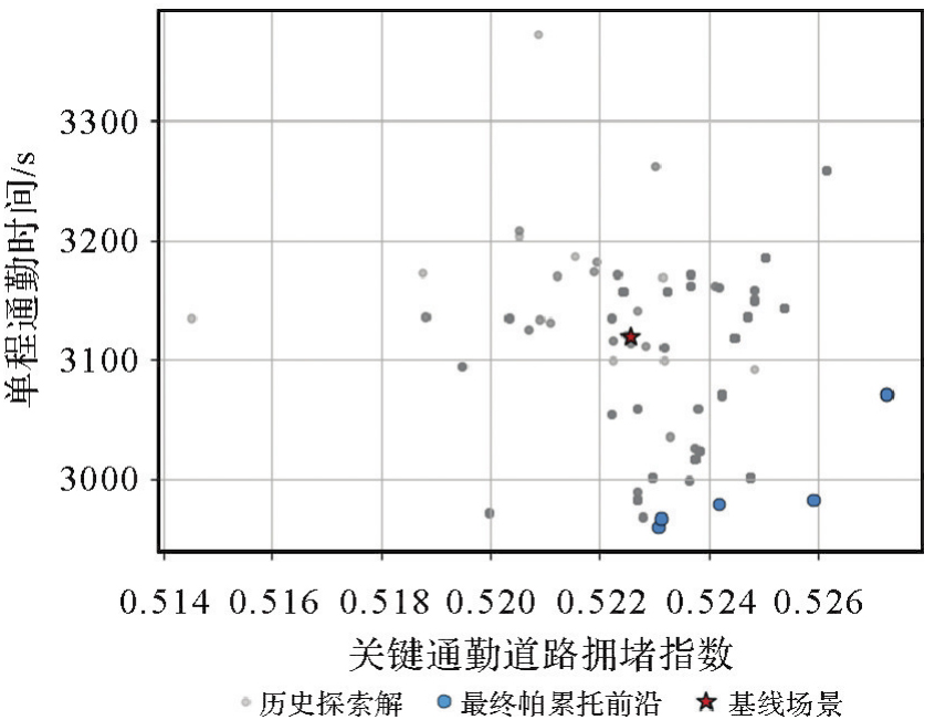
表2
起降场布局的帕累托解集方案"
| 方案 | 站点数量 | 站点序号 | 航线数量 | 总容量(机位) | 目标1:单程通勤时间/s | 目标2:关键通勤道路拥堵指数 | UAM分担率/(%) |
|---|---|---|---|---|---|---|---|
| 1 | 27 | 1,2,3,5,6,8,10,12,13,14,16,17,20,23,24,25,26,27,29,31,32,33,34,35,37,38,40 | 150 | 276 | 2 959.261 3 | 0.523 1 | 6.60 |
| 2 | 22 | 5,8,9,10,12,13,14,17,19,20,24,25,26,27,29,31,32,33,35,37,38,40 | 94 | 228 | 2 966.758 2 | 0.523 1 | 5.55 |
| 3 | 25 | 5,6,8,9,10,12,13,14,16,17,20,21,23,24,25,26,27,31,32,33,34,35,37,38,40 | 134 | 260 | 2 979.004 2 | 0.524 2 | 6.25 |
| 4 | 23 | 5,8,9,10,12,13,14,16,17,20,23,24,25,26,27,29,31,32,33,35,37,38,40 | 106 | 240 | 2 982.306 1 | 0.525 9 | 6.03 |
| 5 | 18 | 3,5,8,9,10,20,22,24,25,27,28,31,32,33,34,35,36,37 | 63 | 172 | 3 070.402 8 | 0.527 3 | 3.59 |
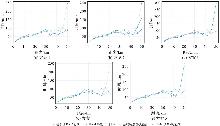
图12
不同起降场布局下通勤时间随距离的变化"
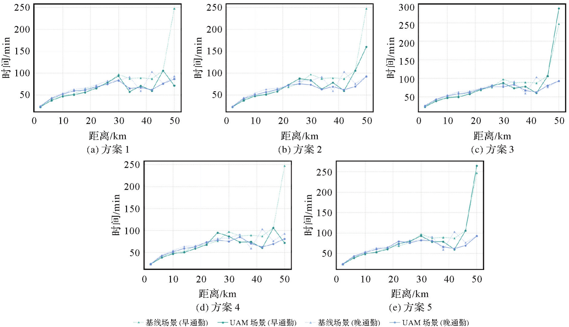
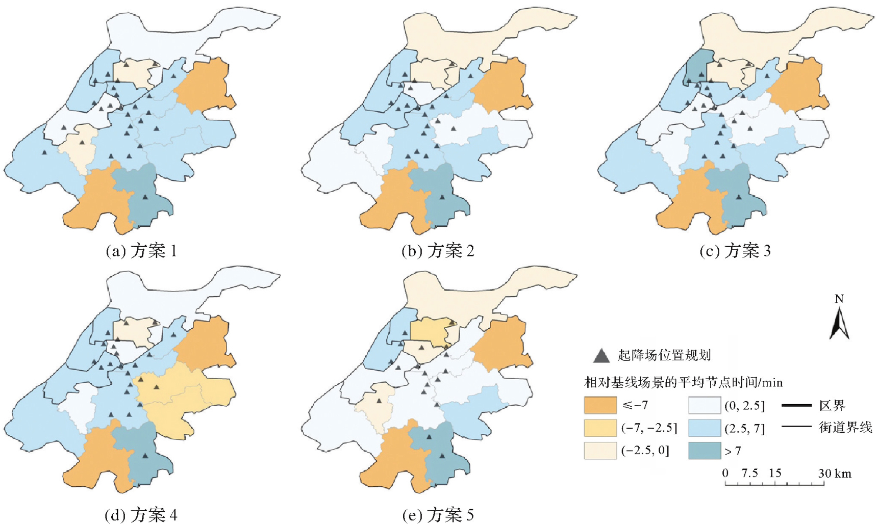
图13
不同起降场布局下的通勤节省时间分布"
| [1] | ZHAO Pengjun, HU Haoyu. Geographical patterns of traffic congestion in growing megacities: big data analytics from Beijing[J]. Cities, 2019, 92: 164-174. |
| [2] | LU Juan, LI Bin, LI He, et al. Expansion of city scale, traffic modes, traffic congestion, and air pollution[J]. Cities, 2021, 108: 102974. |
| [3] | GOYAL R, COHEN A. Advanced air mobility: opportunities and challenges deploying eVTOLs for air ambulance service[J]. Applied Sciences, 2022, 12(3): 1183. |
| [4] | 廖小罕, 黄耀欢, 刘霞. 低空经济时代地理信息科技发展的机遇和挑战[J]. 地球信息科学学报, 2025, 27(1): 1-9. |
| LIAO Xiaohan, HUANG Yaohuan, LIU Xia. Opportunities and challenges in developing geographic information science and technology in the era of the low-altitude economy[J]. Journal of Geo-information Science, 2025, 27(1): 1-9. | |
| [5] | MORADI N, WANG Chun, MAFAKHERI F. Urban air mobility for last-mile transportation: a review[J]. Vehicles, 2024, 6(3): 1383-1414. |
| [6] | WANG Leilei, DENG Xiaoheng, GUI Jinsong, et al. A review of urban air mobility-enabled intelligent transportation systems: mechanisms, applications and challenges[J]. Journal of Systems Architecture, 2023, 141: 102902. |
| [7] | 陈军, 高崟, 郭辰阳, 等. 实景三维赋能低空经济的基本思路与重点任务[J]. 时空信息学报, 2025, 32(1): 1-10. |
| CHEN Jun, GAO Yin, GUO Chenyang, et al. Harnessing 3D realistic geospatial landscape model to empower the low-altitude economy: fundamental problems and major tasks[J]. Journal of Spatio-Temporal Information, 2025, 32(1): 1-10. | |
| [8] | BULUSU V, ONAT E B, SENGUPTA R, et al. A traffic demand analysis method for urban air mobility[J]. IEEE Transactions on Intelligent Transportation Systems, 2021, 22(9): 6039-6047. |
| [9] | ROTHFELD R, FU Mengying, BALAĆ M, et al. Potential urban air mobility travel time savings: an exploratory analysis of Munich, Paris, and San Francisco[J]. Sustainability, 2021, 13(4): 2217. |
| [10] | CUMMINGS C, MAHMASSANI H. Comparing urban air mobility network airspaces: experiments and insights[J]. Transportation Research Record: Journal of the Transportation Research Board, 2024, 2678(4): 440-454. |
| [11] | PUKHOVA A, LLORCA C, MORENO A, et al. Flying taxis revived: can urban air mobility reduce road congestion?[J]. Journal of Urban Mobility, 2021, 1: 100002. |
| [12] | SYED N, RYE M, ADE M, et al. Preliminary considerations for ODM air traffic management based on analysis of commuter passenger demand and travel patterns for the silicon valley region of California[C]//Proceedings of the 17th AIAA Aviation Technology, Integration, and Operations Conference. Reston: AIAA, 2017: 3082. |
| [13] | SCHWEIGER K, PREIS L. Urban air mobility: systematic review of scientific publications and regulations for vertiport design and operations[J]. Drones, 2022, 6(7): 179. |
| [14] | BRUNELLI M, DITTA C C, POSTORINO M N. New infrastructures for urban air mobility systems: a systematic review on vertiport location and capacity[J]. Journal of Air Transport Management, 2023, 112: 102460. |
| [15] | HUANG Yiman, ZHANG Anshu, SU Yuezhu, et al. Comparative analysis of metro passengers' mobility patterns and jobs-housing balance of metropolitan[J]. Journal of Geodesy and Geoinformation Science, 2024, 7(2): 1-17. |
| [16] | ZHOU Yuqing, FU Xiao, TANG Tianli, et al. Assessing resilience of transit networks: an activity-based space-time accessibility analysis[J]. Sustainable Cities and Society, 2025, 130: 106676. |
| [17] | LIU Yan, TONG L C, ZHU Xi, et al. Dynamic activity chain pattern estimation under mobility demand changes during COVID-19[J]. Transportation Research Part C: Emerging Technologies, 2021, 131: 103361. |
| [18] | FU Xiao, ZHANG Yi, DE DIOS ORTÚZAR J, et al. Activity-travel pattern inference based on multi-source big data[J]. Transport Reviews, 2025, 45(1): 26-48. |
| [19] | DELCEA C, CHIRITA N. Exploring the applications of agent-based modeling in transportation[J]. Applied Sciences, 2023, 13(17): 9815. |
| [20] | ROTHFELD R, BALAC M, PLOETNER K O, et al. Agent-based simulation of urban air mobility[C]//Proceedings of 2018 Modeling and Simulation Technologies Conference. Atlanta: AIAA, 2018: 3891. |
| [21] | HAGSPIHL T, KOLISCH R, SCHIFFELS S. Planning an airport shuttle network with air taxis using choice-based optimization[J]. OR Spectrum, 2025: 1-35. |
| [22] | ROTHFELD R, STRAUBINGER A, FU Mengying, et al. Urban air mobility[M]//Demand for emerging transportation systems. Amsterdam: Elsevier, 2020: 267-284. |
| [23] | JIANG Yu, LI Zhichao, WANG Yasha, et al. Vertiport location for eVTOL considering multidimensional demand of urban air mobility: an application in Beijing[J]. Transportation Research Part A: Policy and Practice, 2025, 192: 104353. |
| [24] | JIANG Xuan, CAO Shangqing, MO Baichuan, et al. Simulation-based optimization for vertiport location selection: a surrogate model with machine learning method[J]. Transportation Research Record: Journal of the Transportation Research Board, 2025, 2679(2): 2099-2110. |
| [25] | PARK H S, JUN C H. A simple and fast algorithm for K-medoids clustering[J]. Expert Systems with Applications, 2009, 36(2): 3336-3341. |
| [26] | 何惠雨, 付晓, 吕启航. 突发事件影响下的城市居民出行活动时空模式研究[J]. 时空信息学报, 2024, 31(2): 259-268. |
| HE Huiyu, FU Xiao, LÜ Qihang. Spatiotemporal patterns of urban residents' travel activities under the impact of emergencies[J]. Journal of Spatio-Temporal Information, 2024, 31(2): 259-268. | |
| [27] | PARVIN H, MINAEI-BIDGOLI B, ALINEJAD-ROKNY H, et al. Data weighing mechanisms for clustering ensembles[J]. Computers & Electrical Engineering, 2013, 39(5): 1433-1450. |
| [28] |
屈文虎, 刘振东, 蔡昊琳, 等. 顾及场景连通性的混合式SfM方法[J]. 测绘学报, 2023, 52(6): 966-979. DOI: .
doi: 10.11947/j.AGCS.2023.20220448 |
|
QU Wenhu, LIU Zhendong, CAI Haolin, et al. A hybrid SfM method considering scene connectivity[J]. Acta Geodaetica et Cartographica Sinica, 2023, 52(6): 966-979. DOI: .
doi: 10.11947/j.AGCS.2023.20220448 |
|
| [29] | HORN A. The multi-agent transport simulation MATSim[M]. London: Ubiquity Press, 2016. |
| [30] | KONG Xiaoqiang, ZHANG Yunlong, EISELE W L, et al. Using an interpretable machine learning framework to understand the relationship of mobility and reliability indices on truck drivers' route choices[J]. IEEE Transactions on Intelligent Transportation Systems, 2022, 23(8): 13419-13428. |
| [31] | HE Feifei, YAN Xuedong, LIU Yang, et al. A traffic congestion assessment method for urban road networks based on speed performance index[J]. Procedia Engineering, 2016, 137: 425-433. |
| [32] | VASCIK P D, HANSMAN R J. Development of vertiport capacity envelopes and analysis of their sensitivity to topological and operational factors[C]//Proceedings of 2019 AIAA Scitech Forum. San Diego: AIAA, 2019: 0526. |
| [33] | CHARYPAR D, NAGEL K. Generating complete all-day activity plans with genetic algorithms[J]. Transportation, 2005, 32(4): 369-397. |
| [34] | SIMONI M D, KOCKELMAN K M, GURUMURTHY K M, et al. Congestion pricing in a world of self-driving vehicles: an analysis of different strategies in alternative future scenarios[J]. Transportation Research Part C: Emerging Technologies, 2019, 98: 167-185. |
| [35] | ZHANG Bo, ZHAO Meng, HU Xiangpei. Location planning of electric vehicle charging station with users' preferences and waiting time: multi-objective bi-level programming model and HNSGA-II algorithm[J]. International Journal of Production Research, 2023, 61(5): 1394-1423. |
| [36] | 刘志远, 付晓. 基于手机大数据的交通规划方法与应用[M]. 北京: 科学出版社, 2022. |
| LIU Zhiyuan, FU Xiao. Traffic planning method and application based on mobile phone big data[M]. Beijing: Science Press, 2022. | |
| [37] | YANG Zhao, ZHANG Ying, BAI Xuelian, et al. Estimation of value of travel time savings using willingness-to-pay method[C]//Proceedings of the 18th COTA International Conference of Transportation Professionals. Beijing: American Society of Civil Engineers, 2018: 2433-2445. |
| [38] | SCHMID B, MOLLOY J, PEER S, et al. The value of travel time savings and the value of leisure in Zurich: estimation, decomposition and policy implications[J]. Transportation Research Part A: Policy and Practice, 2021, 150: 186-215. |
| [39] | COPPOLA P, DE FABIIS F, SILVESTRI F. Urban air mobility (UAM): airport shuttles or city-taxis?[J]. Transport Policy, 2024, 150: 24-34. |
| [1] | 吴明光, 成梓铭. 顾及使用场景的绿色地图颜色生成方法研究[J]. 测绘学报, 2026, 55(3): 390-403. |
| [2] | 杨敏, 马宏然, 孔博, 刘鹏程, 艾廷华. 基于预训练模型的矢量海岸线形态模式判别方法[J]. 测绘学报, 2026, 55(3): 404-414. |
| [3] | 禹文豪, 曾子怡, 张一帆, 钱海忠. 融合欧氏空间邻近与拓扑邻接信息预训练模型的路网网格模式[J]. 测绘学报, 2026, 55(3): 415-424. |
| [4] | 禄小敏, 张志义, 闫浩文, 何毅, 苏小宁. 融合深度图信息最大化和多层感知机的建筑物群组模式识别方法[J]. 测绘学报, 2026, 55(3): 425-438. |
| [5] | 成晓强, 赵家威, 刘鹏程. 基于距离-相似性隐喻的空间交互可视化[J]. 测绘学报, 2026, 55(3): 536-547. |
| [6] | 王泽矫, 向隆刚, 王猛, 王兴娟, 刘清. 融合层级特征与多样化注意力的道路面与中心线协同提取网络[J]. 测绘学报, 2026, 55(3): 548-563. |
| [7] | 徐智邦. 实体城市的多层次边界识别、模式分析与扩张模拟[J]. 测绘学报, 2026, 55(3): 566-566. |
| [8] | 冉耘博, 杨雪, 周文豪, 吴承恩, 周宝定, 唐炉亮, 李清泉. 多维偏好增强型对抗深度强化学习驱动的行人路径规划[J]. 测绘学报, 2026, 55(2): 191-205. |
| [9] | 王立增, 程诗奋, 杨一涛, 王培晓, 陆锋. 局部-全局联合感知的时空自适应交通集成预测方法[J]. 测绘学报, 2026, 55(2): 206-221. |
| [10] | 王少华, 梁浩健, 苏澄, 徐大川, 周亮, 秦昆. 耦合时空大数据和人工智能的城市设施配置优化研究进展与展望[J]. 测绘学报, 2026, 55(2): 222-235. |
| [11] | 郭军豪, 吴明治, 王培晓, 张恒才. 一种面向定点稀疏轨迹的密度聚类停留点识别方法[J]. 测绘学报, 2026, 55(2): 249-260. |
| [12] | 李冠男. 道路实景三维模型自动构建方法[J]. 测绘学报, 2026, 55(2): 378-378. |
| [13] | 刘鹏程, 成晓强, 肖天元, 杨敏, 艾廷华. 一种面向地图综合建筑多边形化简的Transformer模型[J]. 测绘学报, 2026, 55(1): 124-137. |
| [14] | 贺彪, 林浩嘉, 郭仁忠, 蒯希, 马丁, 张琛. 基于视觉感知的三维空间相似关系量化计算[J]. 测绘学报, 2026, 55(1): 138-153. |
| [15] | 李维炼, 冉晴晴, 党沛, 朱军, 朱庆, 张恒. 耦合LLMs-KG的地下车站设施洪水脆弱性级联效应分析方法[J]. 测绘学报, 2026, 55(1): 154-168. |
| 阅读次数 | ||||||
|
全文 |
|
|||||
|
摘要 |
|
|||||