


测绘学报 ›› 2026, Vol. 55 ›› Issue (10): 1839-1851.doi: 10.11947/j.AGCS.2026.20260095
刘瑞1,2( ), 姚东辰1,2(), 周棋1,2
收稿日期:2026-03-19
修回日期:2026-08-27
出版日期:2026-11-16
发布日期:2026-11-16
通讯作者:
姚东辰
E-mail:lr@cdut.edu.cn;yaodongchen@stu.cdut.edu.cn
作者简介:刘瑞(1979—),男,博士,副教授,研究方向为地球探测与信息技术。E-mail:lr@cdut.edu.cn
基金资助:
Rui Liu1,2(), Dongchen Yao1,2(), Qi Zhou1,2
Received:2026-03-19
Revised:2026-08-27
Online:2026-11-16
Published:2026-11-16
Contact:
Dongchen Yao
E-mail:lr@cdut.edu.cn;yaodongchen@stu.cdut.edu.cn
About author:Liu Rui (1979—), male, PhD, associate professor, majors in geodetection and information technology. E-mail: lr@cdut.edu.cn
Supported by:摘要:
利用遥感影像实现准确、高效的滑坡地质灾害识别对灾害评估与应急管理具有重要意义。然而,滑坡的形态不规则、尺度差异显著且背景复杂,现有方法难以兼顾分割精度与计算效率。针对上述问题,本文提出一种基于可变形卷积的轻量化语义分割模型DC-LightSeg。该模型结合大核分组卷积与可变形卷积动态调整感受野,精准捕捉滑坡的不规则边界和破碎特征;同时,引入软池化(SoftPool)与改进的双向特征金字塔网络(BiFPN),以加强小尺度滑坡特征保留和多尺度信息融合。在毕节和尼泊尔两个公开滑坡数据集上的试验结果表明,DC-LightSeg参数量仅为1.23×10⁶,并取得较有竞争力的分割性能:毕节数据集上的F1值、召回率、精确率和交并比(IoU)分别为88.78%、88.96%、88.60%和79.82%;尼泊尔数据集上的F1值、召回率、精确率和交并比分别为72.06%、78.40%、66.67%和56.33%。结果表明,该模型在较低参数量下兼顾了识别精度与计算效率,可为资源受限条件下的滑坡遥感快速识别提供参考。
中图分类号:
刘瑞, 姚东辰, 周棋. DC-LightSeg:基于可变形卷积的轻量化滑坡语义分割模型[J]. 测绘学报, 2026, 55(10): 1839-1851.
Rui Liu, Dongchen Yao, Qi Zhou. DC-LightSeg: a lightweight landslide semantic segmentation model based on deformable convolutions[J]. Acta Geodaetica et Cartographica Sinica, 2026, 55(10): 1839-1851.
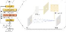
图1
动态感受野模块架构注:⊕为相加,为激活操作。"
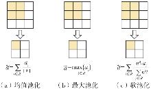
图2
不同池化方法及其原理"
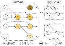
图3
BiFPN结构"
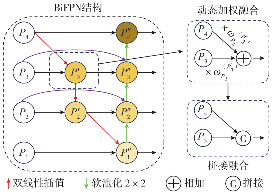
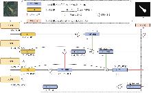
图4
DC-LightSeg结构"

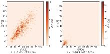
图5
毕节与尼泊尔滑坡数据集中滑坡与非滑坡样本比例"
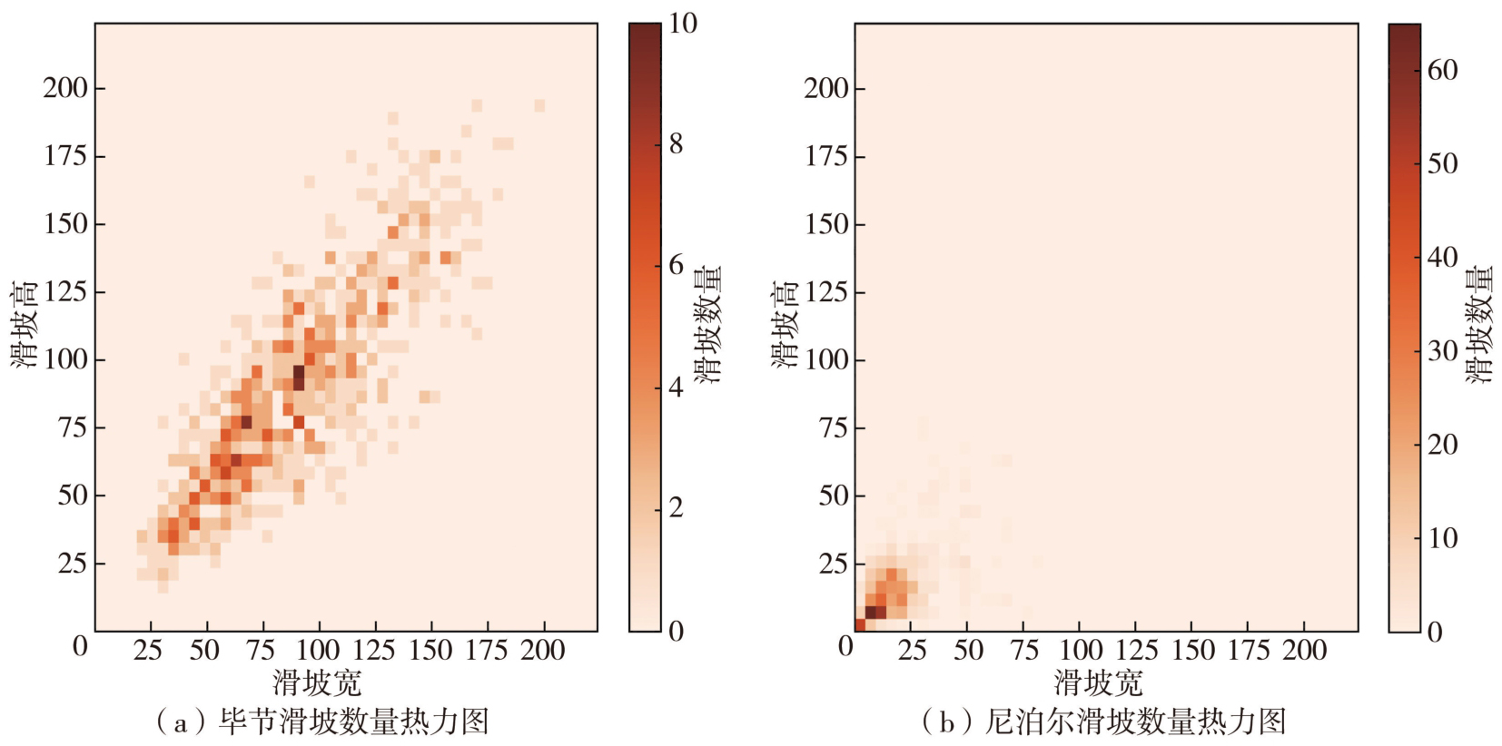
表1
滑坡数据集介绍"
| 数据集 | 数量 | 数据集划分 | 最小滑坡像素个数 | 最大滑坡像素个数 | 图像大小/像素 | 正样本像素占比/(%) |
|---|---|---|---|---|---|---|
| 毕节数据集 | 770 | 7∶2∶1 | 264 | 23 706 | 224×224 | 10.12 |
| 尼泊尔数据集 | 275 | 7∶2∶1 | 1 | 2095 | 224×224 | 3.03 |
表2
试验模型超参数设置"
| 参数 | 设置 |
|---|---|
| 迭代输入图像数量 | 4 |
| 最大训练轮数 | 150 |
| 最大学习率 | 2×10⁻⁴ |
| 最小学习率 | 1×10⁻⁶ |
| 优化器 | AdamW |
| 学习策略 | WarmupCosineAnnealingLR |
表3
不同语义分割模型性能指标评价"
| 模型 | 骨干网络 | 毕节数据集 | 尼泊尔数据集 | 参数量 | FLOPs | ||||||
|---|---|---|---|---|---|---|---|---|---|---|---|
| 召回率 | 精确率 | F1值 | 交并比 | 召回率 | 精确率 | F1值 | 交并比 | ||||
| UNet | — | 81.28±0.72 | 90.27±0.73 | 85.53±0.20 | 74.72±0.32 | 61.84±1.32 | 74.20±1.18 | 67.43±0.40 | 50.87±0.46 | 1.73×10⁷ | 4.51×10¹⁰ |
| UNet++ | — | 82.56±0.54 | 89.66±0.74 | 85.96±0.09 | 75.38±0.74 | 63.05±1.27 | 74.13±1.55 | 68.17±0.23 | 51.65±0.26 | 3.34×10⁷ | 1.20×10¹¹ |
| Segformer | MIT_B5 | 84.44±0.13 | 88.98±0.10 | 86.65±0.03 | 76.45±0.06 | 62.99±2.13 | 70.23±3.66 | 66.30±0.64 | 49.59±0.72 | 8.46×10⁷ | 1.91×10¹⁰ |
| MFFENet | Resnet101 | 81.76±0.64 | 90.82±0.22 | 86.05±0.31 | 75.52±0.48 | 67.49±0.61 | 74.43±1.09 | 70.79±0.45 | 54.79±0.54 | 7.12×10⁷ | 1.21×10¹¹ |
| RIPF_UNet | Vgg16 | 83.29±0.63 | 89.73±0.59 | 86.39±0.19 | 76.04±0.30 | 63.04±1.37 | 73.38±1.98 | 67.78±0.23 | 51.26±0.27 | 2.27×10⁷ | 5.09×10¹⁰ |
| Att_deeplabv3+ | Resnet50 | 84.77±0.44 | 90.67±0.51 | 87.61±0.09 | 77.96±0.15 | 61.90±2.13 | 74.29±3.60 | 67.42±0.46 | 50.86±0.53 | 3.98×10⁷ | 5.03×10¹⁰ |
| ResUNet_BFA | Resnet50 | 82.75±0.67 | 90.49±0.41 | 86.44±0.23 | 76.13±0.36 | 64.28±1.04 | 73.86±1.54 | 68.70±0.31 | 52.33±0.37 | 1.03×10⁸ | 5.83×10¹⁰ |
| DC-LightSeg | DRFM | 88.59±0.08 | 88.10±0.11 | 88.10±0.09 | 79.07±0.24 | 67.59±1.60 | 76.45±2.24 | 71.70±0.31 | 55.89±0.37 | 1.23×10⁶ | 1.40×10¹⁰ |
图6
不同语义分割模型在两种滑坡数据集下识别结果对比"
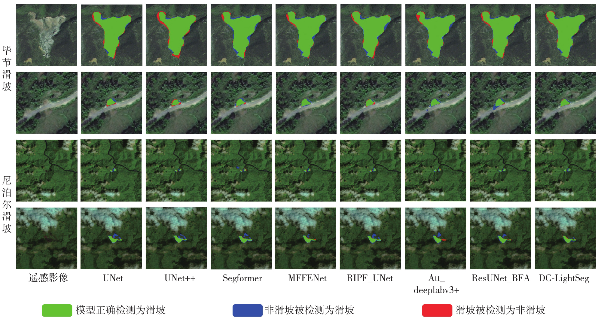
表4
DRFM模块消融试验结果"
| 编号 | 中间结构 | 残差 | 毕节数据集 | 尼泊尔数据集 | 参数量 | FLOPs | ||
|---|---|---|---|---|---|---|---|---|
| F1值/(%) | 交并比/(%) | F1值/(%) | 交并比/(%) | |||||
| A0 | √ | 77.55 | 63.33 | 67.43 | 50.87 | 1.04×10⁶ | 1.28×10¹⁰ | |
| A1 | 3×3卷积 | √ | 80.36 | 67.17 | 68.19 | 51.74 | 4.18×10⁶ | 2.02×10¹⁰ |
| A2 | 5×5卷积 | √ | 83.62 | 71.85 | 67.02 | 50.40 | 9.75×10⁶ | 3.34×10¹⁰ |
| A3 | 7×7卷积 | √ | 84.09 | 72.55 | 67.17 | 50.57 | 1.81×10⁷ | 5.31×10¹⁰ |
| A4 | 3×3Deform | √ | 79.28 | 65.67 | 65.18 | 48.35 | 1.20×10⁶ | 1.38×10¹⁰ |
| A5 | 3×3卷积+Deform | √ | 71.33 | 55.44 | 66.88 | 50.25 | 4.34×10⁶ | 2.12×10¹⁰ |
| A6(DC-LightSeg) | 5×5 DW+Deform | √ | 88.78 | 79.82 | 72.06 | 56.33 | 1.23×10⁶ | 1.40×10¹⁰ |
| A7 | 5×5 DW+Deform | 88.41 | 79.23 | 65.05 | 48.20 | 1.23×10⁶ | 1.40×10¹⁰ | |
| A8 | 5×5 DW+空洞卷积 | √ | 84.74 | 73.52 | 70.03 | 53.89 | 4.21×10⁶ | 2.04×10¹⁰ |
表5
模型消融试验"
| 数据集 | 解码器 | 融合方式 | 均值池化 | 最大池化 | 软池化 | 召回率 | 精确率 | F1值 | 交并比 |
|---|---|---|---|---|---|---|---|---|---|
| 毕节滑坡 | BiFPN | 加权融合 | √ | 89.94 | 85.89 | 87.87 | 78.37 | ||
| √ | 90.79 | 83.40 | 86.94 | 76.89 | |||||
| √ | 89.90 | 86.59 | 88.22 | 78.92 | |||||
| BiFPN | 拼接融合 | √ | 89.65 | 86.81 | 88.21 | 78.90 | |||
| √ | 92.63 | 81.51 | 86.72 | 76.55 | |||||
| √ | 88.96 | 88.60 | 88.78 | 79.82 | |||||
| 尼泊尔滑坡 | BiFPN | 加权融合 | √ | 72.87 | 67.72 | 70.20 | 54.08 | ||
| √ | 72.36 | 63.60 | 67.69 | 51.17 | |||||
| √ | 74.53 | 68.47 | 71.37 | 55.48 | |||||
| BiFPN | 拼接融合 | √ | 77.62 | 65.10 | 70.81 | 54.81 | |||
| √ | 72.30 | 68.41 | 70.30 | 54.20 | |||||
| √ | 78.40 | 66.67 | 72.06 | 56.33 |
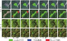
图7
不同池化和特征融合组合下的可视化识别结果对比"
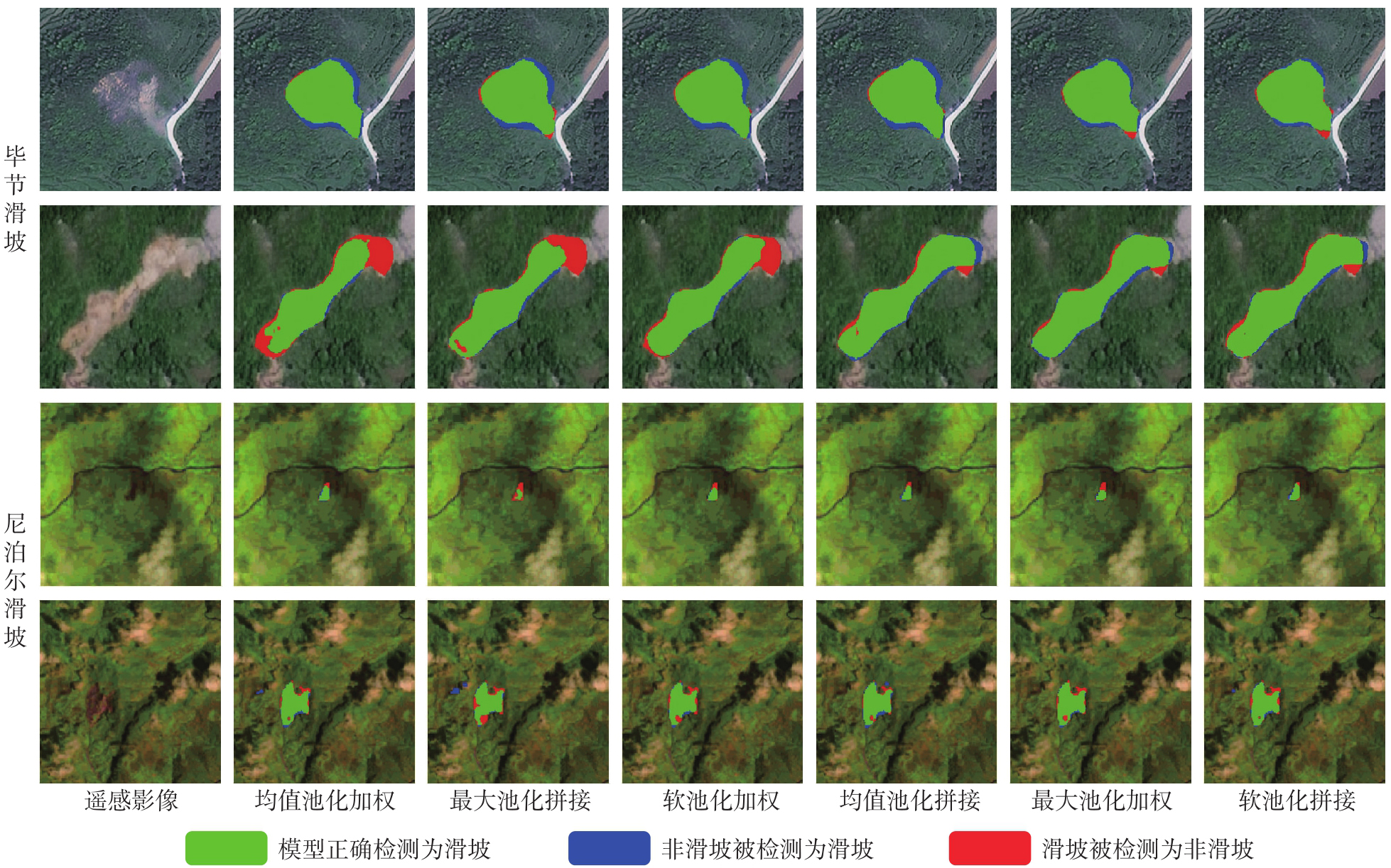
表6
BiFPN与FPN在不同融合策略下的性能对比"
| 数据集 | 解码器 | 融合方式 | 召回率/(%) | 精确率/(%) | F1值/(%) | 交并比/(%) | 参数量 | FLOPs |
|---|---|---|---|---|---|---|---|---|
| 毕节数据集 | BiFPN | 加权融合 | 85.17 | 89.49 | 87.28 | 77.43 | 1.16×10⁶ | 13.54×10⁹ |
| 拼接融合 | 88.95 | 88.60 | 88.78 | 79.82 | 1.23×10⁶ | 13.97×10⁹ | ||
| FPN | 加权融合 | 86.80 | 86.92 | 86.86 | 76.77 | 0.91×10⁶ | 10.09×10⁹ | |
| 拼接融合 | 86.23 | 87.31 | 86.77 | 76.63 | 0.94×10⁶ | 10.63×10⁹ | ||
| 尼泊尔数据集 | BiFPN | 加权融合 | 62.41 | 77.54 | 69.16 | 52.86 | 1.16×10⁶ | 13.54×10⁹ |
| 拼接融合 | 78.40 | 66.67 | 72.06 | 56.33 | 1.23×10⁶ | 13.97×10⁹ | ||
| FPN | 加权融合 | 77.20 | 52.70 | 62.64 | 45.61 | 0.91×10⁶ | 10.09×10⁹ | |
| 拼接融合 | 78.11 | 54.92 | 64.50 | 47.60 | 0.94×10⁶ | 10.63×10⁹ |
| [1] | Li Yange, Chen Guangqi, Han Zheng, et al. A hybrid automatic thresholding approach using panchromatic imagery for rapid mapping of landslides[J]. GIScience & Remote Sensing, 2014, 51(6): 710-730. |
| [2] | Chen Shuai, Miao Zelang, Wu Lixin, et al. Application of an incomplete landslide inventory and one class classifier to earthquake-induced landslide susceptibility mapping[J]. IEEE Journal of Selected Topics in Applied Earth Observations and Remote Sensing, 2020, 13: 1649-1660. |
| [3] | Nhu V H, Mohammadi A, Shahabi H, et al. Landslide susceptibility mapping using machine learning algorithms and remote sensing data in a tropical environment[J]. International Journal of Environmental Research and Public Health, 2020, 17(14): 4933. |
| [4] | 张雷, 眭天波, 黄成兵, 等. 基于多源遥感数据的泸定同震滑坡识别[J]. 测绘通报, 2025(1): 83-87, 126. |
| Zhang Lei, Sui Tianbo, Huang Chengbing, et al. Co-seismic landslide classification in Luding using multi-source remote sensing data[J]. Bulletin of Surveying and Mapping, 2025(1): 83-87, 126. | |
| [5] | 巨袁臻, 许强, 金时超, 等. 使用深度学习方法实现黄土滑坡自动识别[J]. 武汉大学学报(信息科学版), 2020, 45(11): 1747-1755. |
| Ju Yuanzhen, Xu Qiang, Jin Shichao, et al. Automatic object detection of loess landslide based on deep learning[J]. Geomatics and Information Science of Wuhan University, 2020, 45(11): 1747-1755. | |
| [6] | 杨远陶, 刘瑞, 曹礼刚, 等. 基于随机森林算法的珠海一号高光谱影像土地利用信息提取[J]. 物探化探计算技术, 2021, 43(6): 818-824. |
| Yang Yuantao, Liu Rui, Cao Ligang, et al. Land use information extraction from hyperspectral images of Zhuhai-1 based on random forest algorithm[J]. Computing Techniques for Geophysical and Geochemical Exploration, 2021, 43(6): 818-824. | |
| [7] | Xu Qingsong, Ouyang Chaojun, Jiang Tianhai, et al. MFFENet and ADANet: a robust deep transfer learning method and its application in high precision and fast cross-scene recognition of earthquake-induced landslides[J]. Landslides, 2022, 19(7): 1617-1647. |
| [8] | Fu Bangjie, Li Yange, Han Zheng, et al. RIPF-UNet for regional landslides detection: a novel deep learning model boosted by reversed image pyramid features[J]. Natural Hazards, 2023, 119(1): 701-719. |
| [9] |
张银胜, 陈戈, 段修贤, 等. 基于多层特征信息融合的滑坡图像分割模型[J]. 测绘学报, 2024, 53(11): 2201-2212. DOI: .
doi: 10.11947/j.AGCS.2024.20230587 |
|
Zhang Yinsheng, Chen Ge, Duan Xiuxian, et al. Landslide image segmentation model based on multi-layer feature information fusion[J]. Acta Geodaetica et Cartographica Sinica, 2024, 53(11): 2201-2212. DOI: .
doi: 10.11947/j.AGCS.2024.20230587 |
|
| [10] | 赵通, 张双成, 何晓宁, 等. 改进的DeepLabV3+模型用于震后高分遥感影像滑坡识别[J]. 遥感学报, 2024, 28(9): 2293-2305. |
| Zhao Tong, Zhang Shuangcheng, He Xiaoning, et al. Improved DeepLabV3+model for landslide identification in high-resolution remote sensing images after earthquakes[J]. National Remote Sensing Bulletin, 2024, 28(9): 2293-2305. | |
| [11] | Lu Wei, Hu Yunfeng, Shao Wei, et al. A multiscale feature fusion enhanced CNN with the multiscale channel attention mechanism for efficient landslide detection (MS2LandsNet) using medium-resolution remote sensing data[J]. International Journal of Digital Earth, 2024, 17(1): 2300731. |
| [12] | Dai Jifeng, Qi Haozhi, Xiong Yuwen, et al. Deformable convolutional networks[C]//Proceedings of 2017 IEEE International Conference on Computer Vision. Venice: IEEE, 2017: 764-773. |
| [13] | 许濒支, 朱庆, 李海峰, 等. 基于多尺度深度注意力模型的遥感影像滑坡提取方法[J]. 测绘地理信息, 2022, 47(3): 108-112. |
| Xu Binzhi, Zhu Qing, Li Haifeng, et al. A landslide extraction method of remote sensing image based on multi-scale depth attention model[J]. Journal of Geomatics, 2022, 47(3): 108-112. | |
| [14] | Tan Mingxing, Le Q V. EfficientNet: rethinking model scaling for convolutional neural networks[C]//Proceedings of the 36th International Conference on Machine Learning. Long Beach: PMLR, 2019, 97: 6105-6114. |
| [15] | Guo Chaoxu, Fan Bin, Zhang Qian, et al. AugFPN: improving multi-scale feature learning for object detection[C]//Proceedings of 2020 IEEE/CVF Conference on Computer Vision and Pattern Recognition. Seattle: IEEE, 2020: 12592-12601. |
| [16] | 郑有凯, 胡君红, 田春欣. 基于自适应特征融合和任务对齐的小目标检测算法[J]. 激光杂志, 2024, 45(2): 36-42. |
| Zheng Youkai, Hu Junhong, Tian Chunxin. Small target detection algorithm based on adaptive feature fusion and task alignment[J]. Laser Journal, 2024, 45(2): 36-42. | |
| [17] | Li Jiajun, Li Qiang, Lu Jinzheng, et al. A transfer learning remote sensing landslide image segmentation method based on nonlinear modeling and large kernel attention[J]. Applied Sciences, 2025, 15(7): 3855. |
| [18] | Wang Junxin, Zhang Qintong, Xie Hao, et al. Enhanced dual-channel model-based with improved UNet++network for landslide monitoring and region extraction in remote sensing images[J]. Remote Sensing, 2024, 16(16): 2990. |
| [19] | Stergiou A, Poppe R, Kalliatakis G. Refining activation downsampling with SoftPool[C]//Proceedings of 2021 IEEE/CVF International Conference on Computer Vision. Montreal: IEEE, 2021: 10337-10346. |
| [20] | Tan Mingxing, Pang Ruoming, Le Q V. EfficientDet: scalable and efficient object detection[C]//Proceedings of 2020 IEEE/CVF Conference on Computer Vision and Pattern Recognition (CVPR). Seattle: IEEE, 2020: 10778-10787. |
| [21] | Salehi S S M, Erdogmus D, Gholipour A. Tversky loss function for image segmentation using 3D fully convolutional deep networks[C]//Proceedings of 2017 Machine Learning in Medical Imaging. Cham: Springer, 2017: 379-387. |
| [22] | Berman M, Triki A R, Blaschko M B. The lovasz-softmax loss: a tractable surrogate for the optimization of the intersection-over-union measure in neural networks[C]//Proceedings of 2018 IEEE/CVF Conference on Computer Vision and Pattern Recognition. Salt Lake City: IEEE, 2018: 4413-4421. |
| [23] | Ji Shunping, Yu Dawen, Shen Chaoyong, et al. Landslide detection from an open satellite imagery and digital elevation model dataset using attention boosted convolutional neural networks[J]. Landslides, 2020, 17(6): 1337-1352. |
| [24] | Bragagnolo L, Rezende L R, Da Silva R V, et al. Convolutional neural networks applied to semantic segmentation of landslide scars[J]. Catena, 2021, 201: 105189. |
| [25] | Lü Pengyuan, Ma Lusha, Li Qiaomin, et al. ShapeFormer: a shape-enhanced vision transformer model for optical remote sensing image landslide detection[J]. IEEE Journal of Selected Topics in Applied Earth Observations and Remote Sensing, 2023, 16: 2681-2689. |
| [26] | 王丽霞, 喜文飞, 史正涛, 等. 深度学习滑坡识别算法中样本不平衡问题的研究[J]. 测绘通报, 2024(5): 12-18. |
| Wang Lixia, Xi Wenfei, Shi Zhengtao, et al. Study on sample unbalance in landslide recognition algorithm based on depth learning[J]. Bulletin of Surveying and Mapping, 2024(5): 12-18. | |
| [27] | He Kaiming, Zhang Xiangyu, Ren Shaoqing, et al. Delving deep into rectifiers: surpassing human-level performance on ImageNet classification[C]//Proceedings of 2015 IEEE International Conference on Computer Vision (ICCV). Santiago: IEEE, 2015: 1026-1034. |
| [28] | Ronneberger O, Fischer P, Brox T. U-Net: convolutional networks for biomedical image segmentation[C]//Proceedings of 2015 Medical Image Computing and Computer-Assisted Intervention. Cham: Springe, 2015: 234-241. |
| [29] | Zhou Zongwei, Rahman Siddiquee M M, Tajbakhsh N, et al. UNet++: a nested U-Net architecture for medical image segmentation[C]//Proceedings of 2018 Deep Learning in Medical Image Analysis and Multimodal Learning for Clinical Decision Support. Cham: Springer, 2018: 3-11. |
| [30] | Xie Enze, Wang Wenhai, Yu Zhiding, et al. SegFormer: simple and efficient design for semantic segmentation with transformers[C]//Proceedings of 2021 Advances in Neural Information Processing Systems. Red Hook: Curran Associates, 2021, 34: 12077-12090. |
| [31] | Zhao Zhenyu, Tan Shucheng, Yang Yiquan, et al. Landslide identification from post-earthquake high-resolution remote sensing images based on ResUNet-BFA[J]. Remote Sensing, 2025, 17(6): 995. |
| [32] | Boureau Y L, Ponce J, LeCun Y. A theoretical analysis of feature pooling in visual recognition[C]//Proceedings of the 27th International Conference on Machine Learning. Madison: Omnipress, 2010: 111-118. |
| [33] | Lee Chen-Yu, Gallagher Patrick W, Tu Zhuowen. Generalizing pooling functions in convolutional neural networks: mixed, gated, and tree[C]//Proceedings of the 19th International Conference on Artificial Intelligence and Statistics. Cadiz: PMLR, 2016, 51: 464-472. |
| [34] | Zafar A, Saba N, Arshad A, et al. Convolutional neural networks: a comprehensive evaluation and benchmarking of pooling layer variants[J]. Symmetry, 2024, 16(11): 1516. |
| [35] | Amhan M, Mearri M, Topal C. Hybrid pooling as a balanced approach to reduce false positives in CNNs[C]//Proceedings of 2025 Signal Processing and Communications Applications Conference. Sile: IEEE, 2025: 1-4. |
| [36] | Shadoul I, Al-Hmouz R, Hossen A, et al. The effect of pooling parameters on the performance of convolution neural network[J]. Artificial Intelligence Review, 2025, 58(9): 271. |
| [37] | Dai Y, Gieseke F, Oehmcke S, et al. Attentional feature fusion[C]//Proceedings of 2021 IEEE Winter Conference on Applications of Computer Vision. Waikoloa: IEEE, 2021: 3559-3568. |
| [38] | Dulal R, Zheng L H, Kabir M A. MHAFF: multihead attention feature fusion of CNN and transformer for cattle identification[J]. IEEE Transactions on AgriFood Electronics, 2025, 3(2): 506-517. |
| [39] | Gao Jinxiong, Geng Xu, Zhang Yonghui, et al. Augmented weighted bidirectional feature pyramid network for marine object detection[J]. Expert Systems with Applications, 2024, 237: 121688. |
| [40] | Ghiasi G, Lin T Y, Le Q V. NAS-FPN: learning scalable feature pyramid architecture for object detection[C]//Proceedings of 2019 IEEE/CVF Conference on Computer Vision and Pattern Recognition. Long Beach: IEEE, 2019: 7029-7038. |
| [1] | 陈西江, 曾敏坤, 宣伟, 邹进贵, 花向红. 多尺度超体素特征聚合网络的三维点云语义分割[J]. 测绘学报, 2026, 55(8): 1414-1424. |
| [2] | 孙咏琪, 戴晨光, 张振超, 秦进春, 宿钰. 融合相对深度的高分辨率光学卫星遥感影像跨域语义分割框架[J]. 测绘学报, 2026, 55(8): 1425-1438. |
| [3] | 赵翔宇, 张春菊, 裴一帆, 李晨曦, 张俊, 徐薇, 兰春, 吕临峰, 梁宏博. SCA-SAM:基于尺度上下文注意力与SAM高效迁移的遥感影像语义分割方法[J]. 测绘学报, 2026, 55(8): 1452-1464. |
| [4] | 王泽矫, 向隆刚, 王猛, 王兴娟, 刘清. 融合层级特征与多样化注意力的道路面与中心线协同提取网络[J]. 测绘学报, 2026, 55(3): 548-563. |
| [5] | 黄鹤, 张鑫泰, 张译丹, 杨军星. 面向大规模激光雷达点云语义分割的长序列几何增强网络[J]. 测绘学报, 2026, 55(10): 1829-1838. |
| [6] | 闫凯, 徐健明, 王桥. 地表异常遥感探测轻量化大模型方法[J]. 测绘学报, 2025, 54(9): 1664-1676. |
| [7] | 万杰, 谢忠, 徐永洋, 陶留锋. 面向城市道路场景的车载LiDAR点云语义分割U形图卷积网络方法[J]. 测绘学报, 2025, 54(7): 1280-1293. |
| [8] | 张正华, 陈国良. 一种轻量且旋转不变的激光雷达位置识别网络[J]. 测绘学报, 2025, 54(1): 90-103. |
| [9] | 胡波, 陈翰新, 任松, 屈英豪, 刘清屹, 涂歆玥, 王大涛. 一种基于分割掩码的隧道裂缝病害自动识别后处理算法[J]. 测绘学报, 2024, 53(9): 1715-1724. |
| [10] | 徐涛, 杨元维, 高贤君, 王志威, 潘越, 李少华, 许磊, 王艳军, 刘波, 余静, 吴凤敏, 孙浩宇. 融合图卷积与多尺度特征的接触网点云语义分割[J]. 测绘学报, 2024, 53(8): 1624-1633. |
| [11] | 黄启灏, 靳国旺, 熊新, 王丽美, 李佳豪. 通道剪枝与知识蒸馏相结合的轻量化SAR目标检测[J]. 测绘学报, 2024, 53(4): 712-723. |
| [12] | 林云浩, 王艳军, 李少春, 蔡恒藩. 一种耦合DeepLab与Transformer的农作物种植类型遥感精细分类方法[J]. 测绘学报, 2024, 53(2): 353-366. |
| [13] | 孙根云, 孙超, 张爱竹. 融合多尺度与边缘特征的道路提取网络[J]. 测绘学报, 2024, 53(12): 2233-2243. |
| [14] | 张银胜, 陈戈, 段修贤, 童俊毅, 单梦姣, 单慧琳. 基于多层特征信息融合的滑坡图像分割模型[J]. 测绘学报, 2024, 53(11): 2201-2212. |
| [15] | 刘家兴, 黄玉春, 石文轩, 叶曦, 杨鹤. 顾及拓扑结构的道路标线提取[J]. 测绘学报, 2024, 53(11): 2213-2227. |
| 阅读次数 | ||||||
|
全文 |
|
|||||
|
摘要 |
|
|||||
