


测绘学报 ›› 2026, Vol. 55 ›› Issue (9): 1582-1598.doi: 10.11947/j.AGCS.2026.20260244
蔺小虎1( ), 闫涛2, 杨必胜2(), 陈驰2, 高毅楠1, 王相1
收稿日期:2026-06-23
修回日期:2026-09-10
出版日期:2026-10-28
发布日期:2026-10-28
通讯作者:
杨必胜
E-mail:xhlin214@xust.edu.cn;bshyang@whu.edu.cn
作者简介:蔺小虎(1989—),男,博士,副教授,研究方向为复杂环境下多源融合智能感知与监测。 E-mail:xhlin214@xust.edu.cn
基金资助:
Xiaohu Lin1(), Tao Yan2, Bisheng Yang2(), Chi Chen2, Yinan Gao1, Xiang Wang1
Received:2026-06-23
Revised:2026-09-10
Online:2026-10-28
Published:2026-10-28
Contact:
Bisheng Yang
E-mail:xhlin214@xust.edu.cn;bshyang@whu.edu.cn
About author:Lin Xiaohu (1989—), male, PhD, associate professor, majors in multi-source fusion-based intelligent sensing and monitoring for complex environments. E-mail: xhlin214@xust.edu.cn
Supported by:摘要:
地下空间精细化制图与智能巡检是支撑机器人自主作业、应急搜救和安全运维的重要基础。然而,现有三维高斯溅射同步定位与建图(3DGS-SLAM)方法主要关注几何重建与视觉渲染质量,在地下复杂环境中仍面临语义感知能力不足、高维语义特征显存占用高以及低光照和深度缺失等退化条件下多视角语义不一致等问题。为此,本文提出一种面向复杂地下空间的开放词汇语义增强3DGS-SLAM方法。首先,结合深度补全与置信度估计模块,利用分割一切模型(SAM)与对比语言-图像预训练(contrastive languageimage pre-training,CLIP)模型构建多尺度开放词汇语义特征场,并通过自编码器压缩CLIP特征,在降低显存占用的同时保持语义判别能力;其次,提出一种融合图像增强残差先验与深度置信度先验的语义不确定性量化模型,并引入时间平滑机制降低低质量观测的语义权重,从而缓解多视角语义不一致;最后,在光度、深度、高斯尺度正则化和光照稳定性约束的基础上,构建不确定性加权的语义损失,形成几何、外观与语义联合优化目标,并支持开放词汇语义查询。为验证本文方法的有效性,依托自主设计集成的移动机器人平台,在多个典型地下空间中进行了试验,本文方法在地下空间中峰值信噪比(PSNR)达23.0 dB、结构相似性指数(SSIM)达0.88,优于SplaTAM、GS3LAM等代表性方法;在ScanNet数据集上,开放词汇分割性能mIoU达39.08%,相较对比方法取得了明显提升。结果表明,该方法能够在复杂地下环境中实现高效、稳定的开放词汇语义建图,为地下空间智能巡检和人机交互提供细粒度语义支撑。
中图分类号:
蔺小虎, 闫涛, 杨必胜, 陈驰, 高毅楠, 王相. 面向复杂地下空间的开放词汇语义增强3DGS-SLAM方法[J]. 测绘学报, 2026, 55(9): 1582-1598.
Xiaohu Lin, Tao Yan, Bisheng Yang, Chi Chen, Yinan Gao, Xiang Wang. An open-vocabulary semantic-enhanced 3DGS-SLAM method for complex underground spaces[J]. Acta Geodaetica et Cartographica Sinica, 2026, 55(9): 1582-1598.
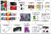
图1
开放词汇语义3DGS-SLAM方法框架"

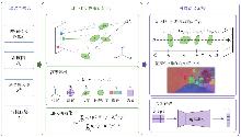
图2
语义高斯建图与优化"

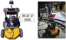
图3
数据采集设备与试验场景"
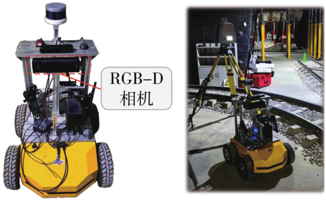
表1
试验设备与规格"
| 设备 | 类型 | 规格 |
|---|---|---|
| 深度相机 | Kinect v2 | 采样率:10 Hz |
| 分辨率:512×424像素 | ||
| 水平70°,垂直60° | ||
| 控制台 | Autolabor-PC | CPU:AMDRyzen33200G/DDR4 8 GB |
| 移动机器人 | Autolabor-Pro1 | 设备模式:四驱 |
| 位移速度:0.5~1.5 m/s | ||
| 角速度:0.56 rad/s | ||
| 台式计算机 | 自定义 | CPU:Intel i7-14700K |
| GPU:NVIDIA GeForce RTX 4090D DDR5 64 GB | ||
| 操作系统:Ubuntu 18.04 |
表2
现场测试数据集统计"
| 场景 | 轨迹长度/m | 面积/m2 | 帧数量 | 场景特征 |
|---|---|---|---|---|
| 采掘巷道 | 24.8 | 78.9 | 1469 | 低光照,运动模糊 |
| 运输巷道 | 27.0 | 74.6 | 1596 | 低光照,重复纹理 |
| 行人通道 | 36.2 | 92.5 | 2230 | 低光照,大场景 |
| 地质巷道 | 29.4 | 101.3 | 1674 | 低光照,弱纹理 |
| 废弃车库 | 16.5 | 45.8 | 832 | 低光照,复杂结构 |
| 电动车库 | 28.0 | 88.5 | 1622 | 低光照,局部遮挡 |
| 水泵房 | 20.5 | 59.4 | 1141 | 重复纹理 |
| 配电室 | 19.1 | 43.8 | 1609 | 遮挡,光照变化 |
| 简报室 | 18.7 | 38.4 | 624 | 白墙,弱纹理 |
图4
地下场景中估计轨迹与参考轨迹的定性对比"
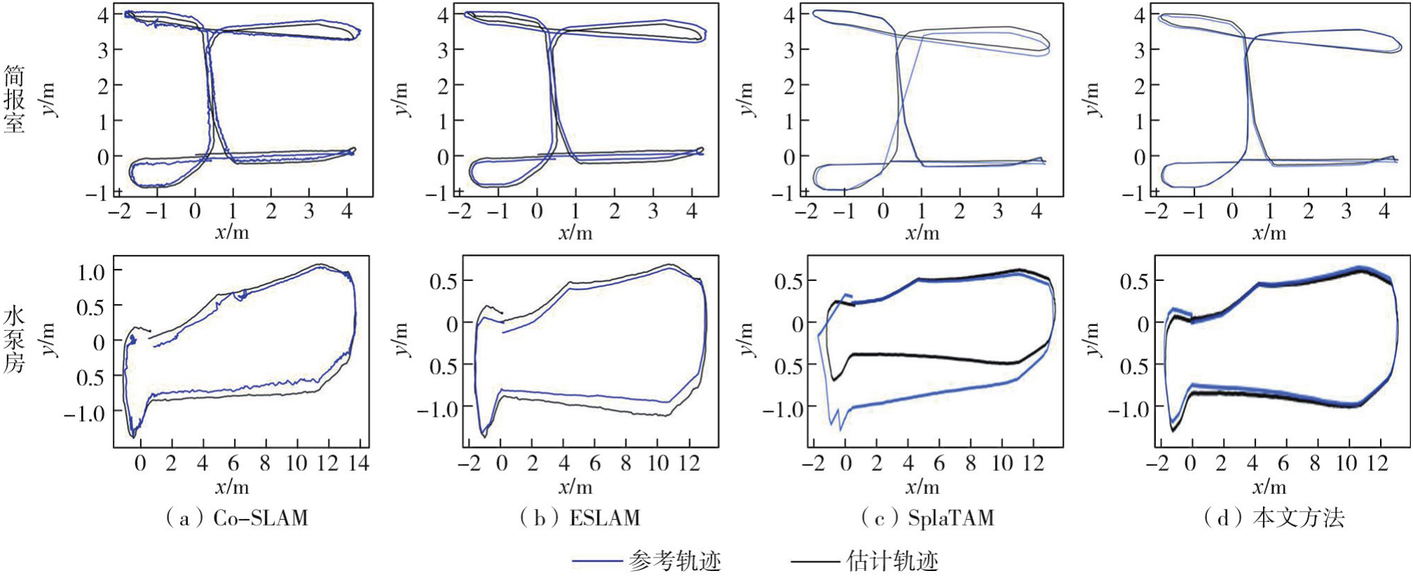
表3
地下数据集定量轨迹跟踪精度对比"
| 方法 | 煤矿场景 | 车库场景 | 地下室场景 | ||||||
|---|---|---|---|---|---|---|---|---|---|
| 采掘巷道 | 运输巷道 | 行人通道 | 地质巷道 | 废弃车库 | 电动车库 | 水泵房 | 配电室 | 简报室 | |
| NICE-SLAM | 18.9 | 16.4 | 14.8 | 29.7 | 12.2 | 26.1 | 9.4 | 7.8 | 10.8 |
| Co-SLAM | 11.0 | 18.3 | 13.3 | 12.6 | 17.4 | 10.5 | 8.9 | 16.9 | 10.3 |
| ESLAM | 9.9 | 10.5 | 7.4 | 10.5 | 8.3 | 7.9 | 7.9 | 5.1 | 9.7 |
| SplaTAM | 12.6 | 22.7 | 18.2 | 24.4 | 16.1 | 20.2 | 11.9 | 12.4 | 11.0 |
| MonoGS | 15.2 | 21.4 | 15.7 | 14.4 | 14.8 | 13.6 | 9.8 | 11.8 | 19.5 |
| GS-ICP SLAM | 9.5 | 11.0 | 7.1 | 8.2 | 11.9 | 10.8 | 6.9 | 10.6 | 11.7 |
| RTG-SLAM | 9.8 | 8.7 | 6.9 | 9.1 | 8.9 | 8.9 | 9.4 | 7.6 | 9.6 |
| GS3LAM | 9.5 | 7.9 | 5.2 | 8.6 | 9.0 | 9.8 | 9.4 | 7.7 | 10.1 |
| 前序方法 | 9.1 | 7.6 | 4.8 | 8.2 | 9.6 | 7.7 | 8.9 | 5.4 | 9.6 |
| 本文方法 | 9.2 | 7.7 | 5.2 | 8.2 | 9.5 | 7.6 | 8.8 | 5.6 | 9.6 |
图5
地下数据集定量渲染性能对比"
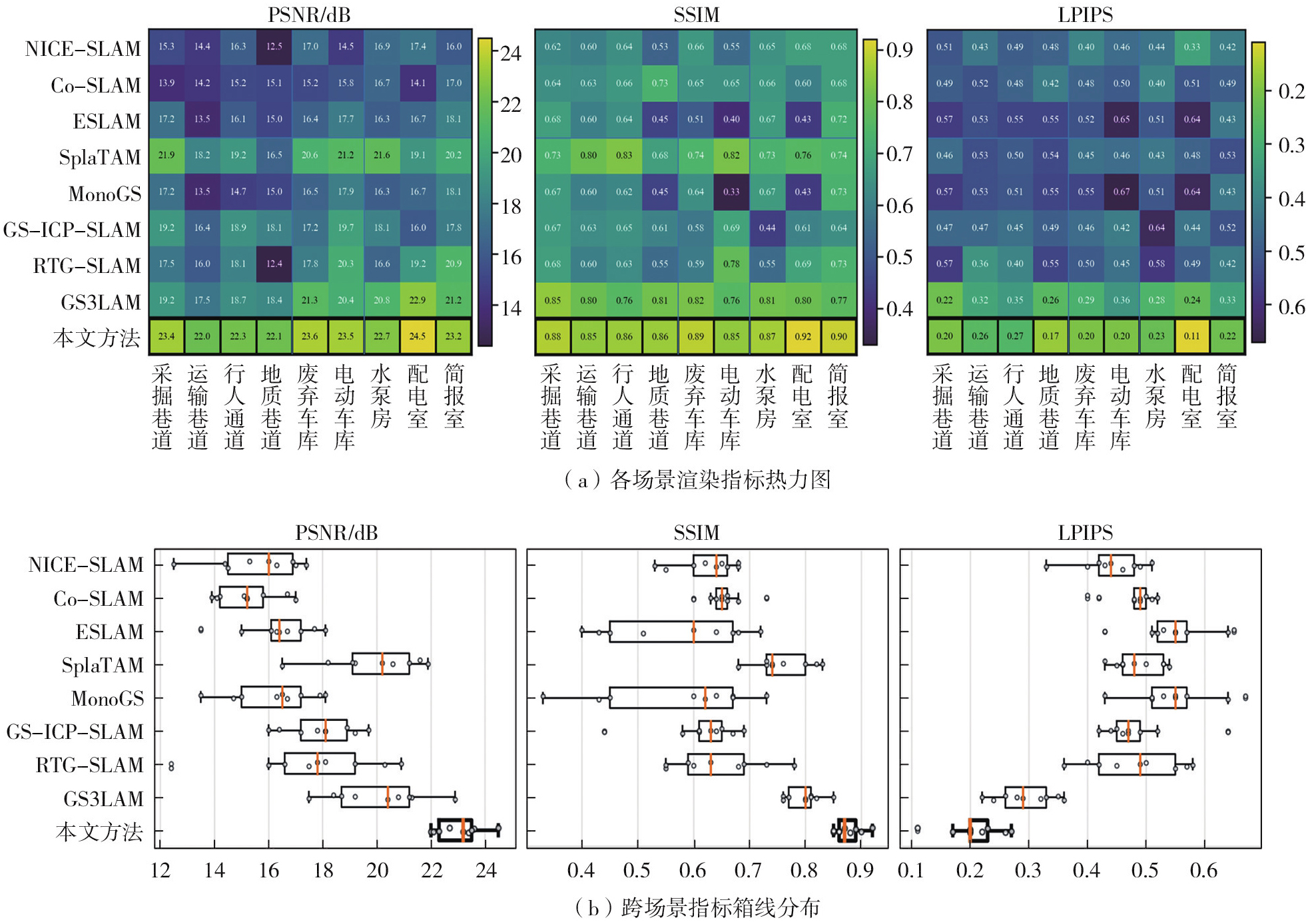
图6
地下数据集定性渲染性能对比"
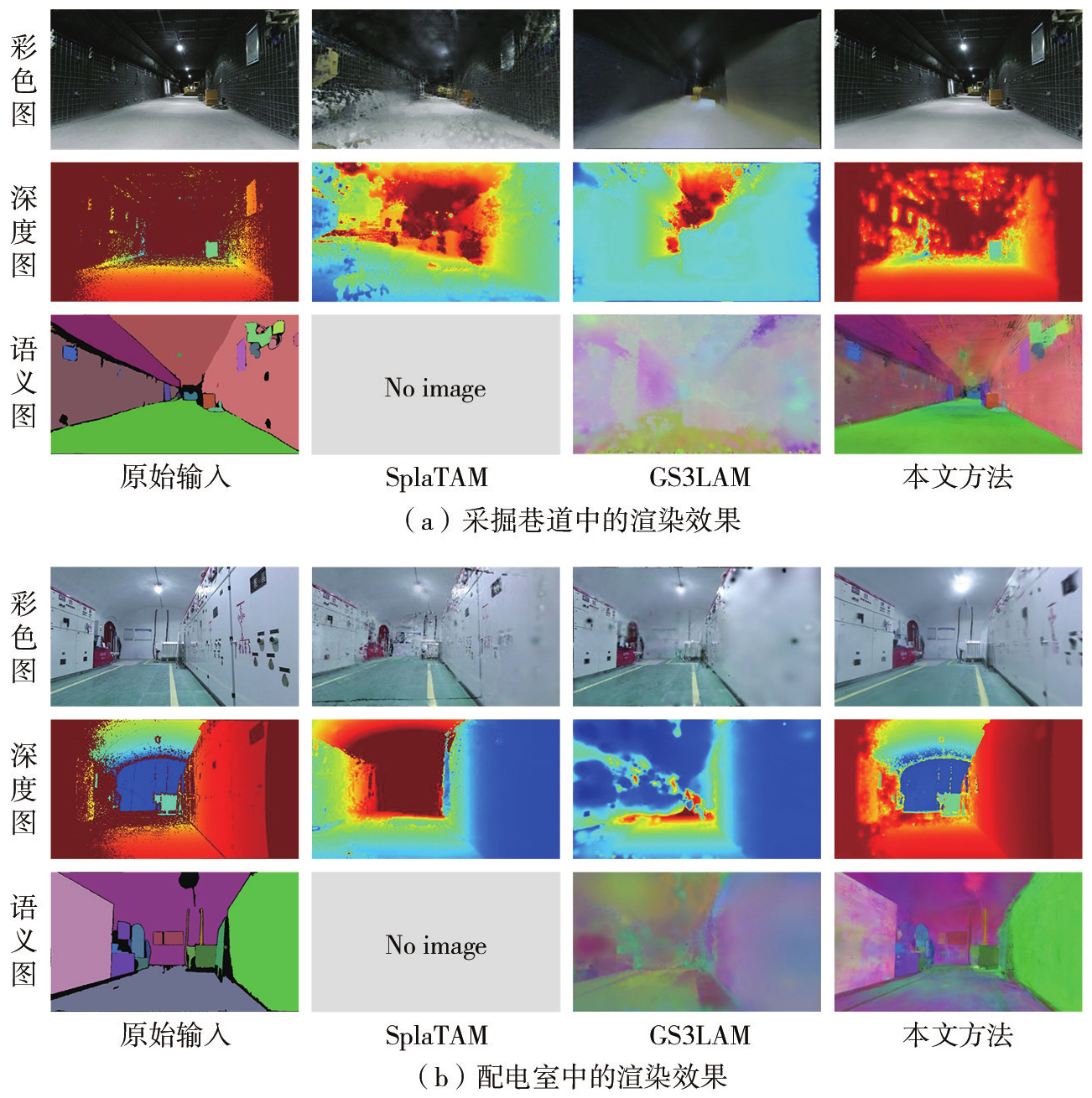
图7
更多场景重建结果对比"
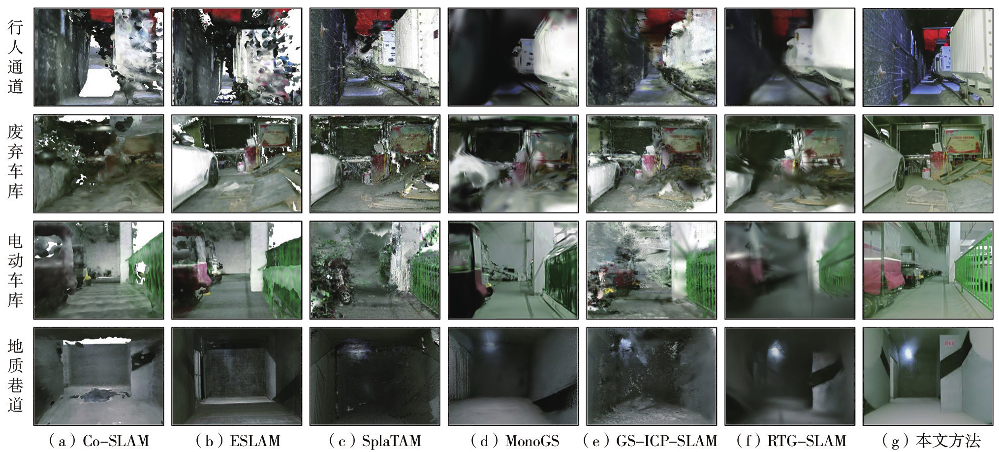
图8
代表性场景三维重建结果展示"
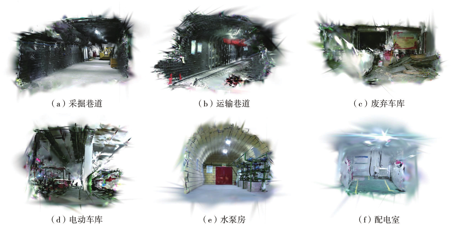
图9
地下数据集语义重建结果"
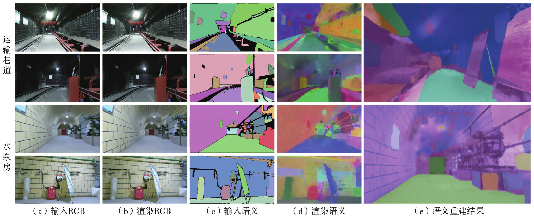
图10
开放词汇查询功能"
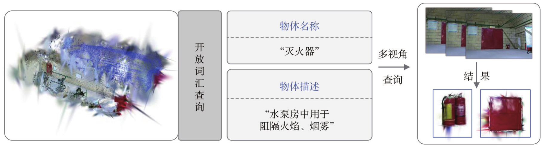
图11
算法在ScanNet数据集上的渲染效果"

表4
ScanNet数据集跟踪与渲染性能对比"
| 方法 | 指标 | scene0062_00 | scene0097_00 | scene0200_00 |
|---|---|---|---|---|
| SplaTAM | PSNR/dB | 21.0 | 26.9 | 21.3 |
| SSIM | 0.80 | 0.90 | 0.79 | |
| LPIPS | 0.27 | 0.22 | 0.36 | |
| ATE/cm | 12.1 | 11.0 | 11.9 | |
| SGS-SLAM | PSNR/dB | 20.8 | 27.2 | 21.1 |
| SSIM | 0.81 | 0.89 | 0.75 | |
| LPIPS | 0.24 | 0.25 | 0.38 | |
| ATE/cm | 11.3 | 10.9 | 11.3 | |
| GS3LAM | PSNR/dB | 22.1 | 28.3 | 22.4 |
| SSIM | 0.82 | 0.90 | 0.80 | |
| LPIPS | 0.22 | 0.21 | 0.31 | |
| ATE/cm | 11.6 | 10.2 | 11.2 | |
| 本文方法 | PSNR/dB | 22.9 | 29.5 | 23.0 |
| SSIM | 0.84 | 0.92 | 0.83 | |
| LPIPS | 0.20 | 0.19 | 0.29 | |
| ATE/cm | 11.3 | 10.2 | 11.0 |
图12
ScanNet数据集定性重建结果对比"
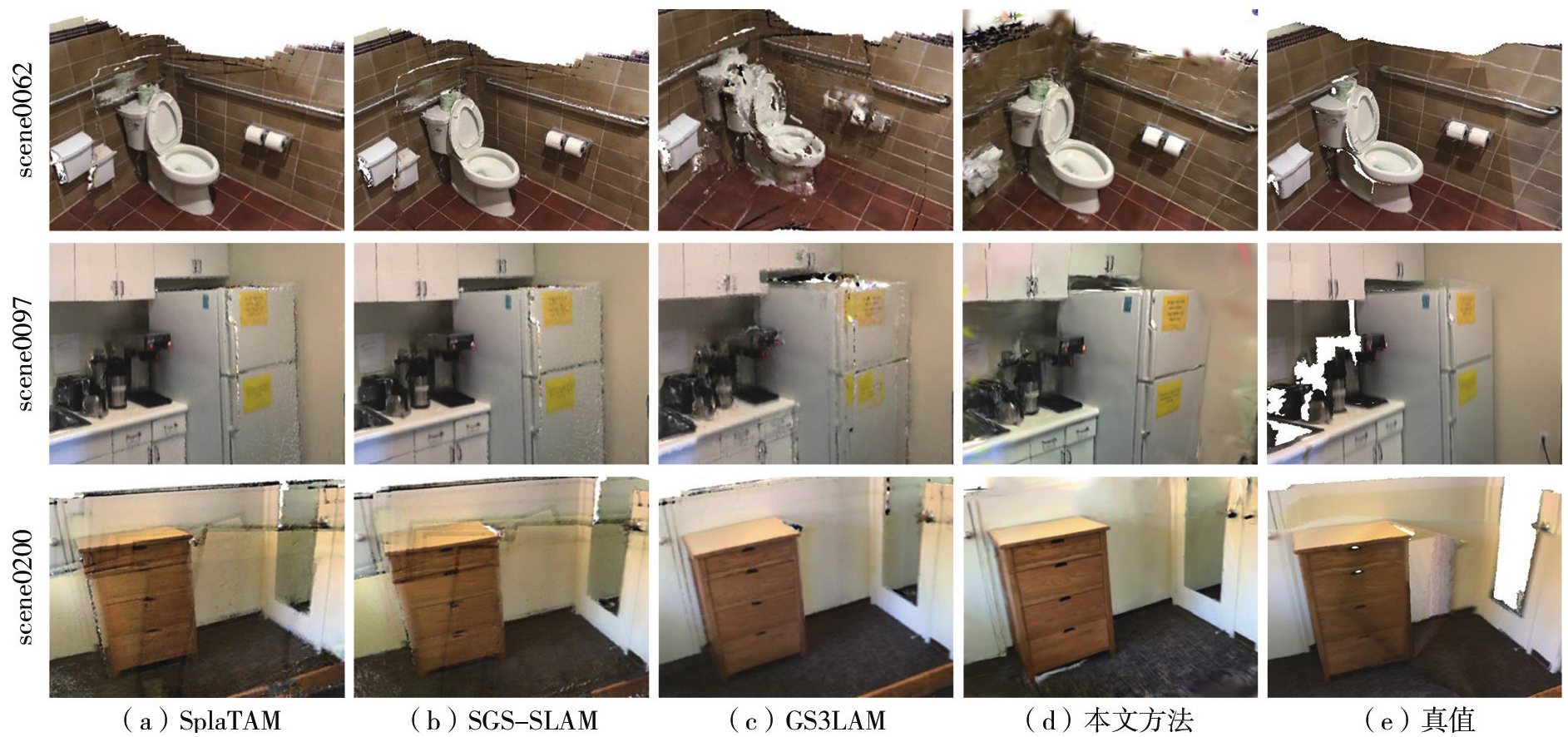
表5
3D开放词汇分割性能对比"
| 方法 | scene0062_00 | scene0097_00 | scene0200_00 | 平均值 | ||||
|---|---|---|---|---|---|---|---|---|
| mIoU | mAcc | mIoU | mAcc | mIoU | mAcc | mIoU | mAcc | |
| LangSplat | 3.51 | 9.58 | 4.49 | 11.27 | 3.14 | 8.79 | 3.71 | 9.88 |
| OpenGaussian | 28.99 | 46.53 | 28.51 | 48.62 | 26.98 | 47.09 | 28.16 | 47.41 |
| 本文方法 | 39.12 | 57.83 | 38.27 | 54.09 | 39.84 | 63.97 | 39.08 | 58.63 |
表6
语义特征压缩对显存占用与运行效率的影响"
| 语义表示方式 | 峰值显存/GB | FPS | mIoU/(%) |
|---|---|---|---|
| 原始CLIP特征 | 显存溢出 | — | — |
| 128维语义嵌入 | 15.9 | 7.9 | 39.02 |
| 本文方法 | 12.3 | 8.8 | 39.08 |
表7
跟踪阶段引入语义损失的影响"
| 跟踪设置 | ATE/cm | FPS |
|---|---|---|
| 不引入语义损失 | 7.9 | 8.8 |
| 引入语义损失 | 8.0 | 6.9 |
表8
不确定性先验消融与时间平滑参数敏感性"
| 消融试验 | 设置 | mIoU | mAcc |
|---|---|---|---|
| 不确定性先验 | 仅增强残差 | 35.62 | 54.83 |
| 仅深度置信度 | 36.34 | 55.71 | |
| 双先验联合 | 37.11 | 56.72 | |
| 时间平滑 | ρ=0.5 | 38.24 | 57.66 |
| ρ=0.8 | 39.08 | 58.63 | |
| ρ=0.9 | 38.61 | 58.05 |
表9
ScanNet场景平均值的关键模块消融试验"
| 设置 | 语义嵌入 | 不确定性权重 | 时间平滑 | PSNR/dB | SSIM | LPIPS | mIoU/(%) |
|---|---|---|---|---|---|---|---|
| 几何+外观建图 | × | × | × | 24.0 | 0.78 | 0.27 | — |
| +开放词汇语义嵌入 | √ | × | × | 24.3 | 0.80 | 0.27 | 34.52 |
| +语义不确定性权重 | √ | √ | × | 24.7 | 0.83 | 0.25 | 37.11 |
| 本文方法 | √ | √ | √ | 25.1 | 0.86 | 0.23 | 39.08 |
| [1] | Lin Xiaohu, Yang Xin, Yao Wanqiang, et al. Graph-based adaptive weighted fusion SLAM using multimodal data in complex underground spaces[J]. ISPRS Journal of Photogrammetry and Remote Sensing, 2024, 217: 101-119. |
| [2] | Kim H, Choi Y. 3D location estimation and tunnel mapping of autonomous driving robots through 3D point cloud registration on underground mine rampways[J]. Underground Space, 2025, 22: 1-20. |
| [3] | Li Yufei, Xie Yakun, Chen Mingzhen, et al. A multi-level semantic constraint approach for highway tunnel scene twin modeling[J]. Journal of Geodesy and Geoinformation Science, 2025, 8(2): 37-56. |
| [4] | Li Xingxing, Zhang Xiaohong, Niu Xiaoji, et al. Progress and achievements of multi-sensor fusion navigation in China during 2019—2023[J]. Journal of Geodesy and Geoinformation Science, 2023, 6(3): 102-114. |
| [5] |
郭迟, 刘阳, 罗亚荣, 等. 图像语义信息在视觉SLAM中的应用研究进展[J]. 测绘学报, 2024, 53(6): 1057-1076. DOI: .
doi: 10.11947/j.AGCS.2024.20230259 |
|
Guo Chi, Liu Yang, Luo Yarong, et al. Research progress in the application of image semantic information in visual SLAM[J]. Acta Geodaetica et Cartographica Sinica, 2024, 53(6): 1057-1076. DOI: .
doi: 10.11947/j.AGCS.2024.20230259 |
|
| [6] |
张继贤, 刘飞. 视觉SLAM环境感知技术现状与智能化测绘应用展望[J]. 测绘学报, 2023, 52(10): 1617-1630. DOI: .
doi: 10.11947/j.AGCS.2023.20220240 |
|
Zhang Jixian, Liu Fei. Review of visual SLAM environment perception technology and intelligent surveying and mapping application[J]. Acta Geodaetica et Cartographica Sinica, 2023, 52(10): 1617-1630. DOI: .
doi: 10.11947/j.AGCS.2023.20220240 |
|
| [7] |
蔺小虎, 杨鑫, 姚顽强, 等. 面向复杂地下空间的多源传感器数据动态加权融合SLAM方法[J]. 测绘学报, 2025, 54(3): 523-535. DOI: .
doi: 10.11947/j.AGCS.2025.20230586 |
|
Lin Xiaohu, Yang Xin, Yao Wanqiang, et al. A dynamic weighted fusion SLAM method using multi-source sensor data in complex underground spaces[J]. Acta Geodaetica et Cartographica Sinica, 2025, 54(3): 523-535. DOI: .
doi: 10.11947/j.AGCS.2025.20230586 |
|
| [8] | 高毅楠, 姚顽强, 蔺小虎, 等. 煤矿井下多重约束的视觉SLAM关键帧选取方法[J]. 煤炭学报, 2024, 49(S1): 472-482. |
| Gao Yinan, Yao Wanqiang, Lin Xiaohu, et al. Visual SLAM keyframe selection method with multiple constraints in underground coal mines[J]. Journal of China Coal Society, 2024, 49(S1): 472-482. | |
| [9] | 陈荣瀚, 丛杨, 刘佳悦, 等. 欠定场景下基于3D高斯溅射的3维重建综述[J/OL]. 机器人, 1-15[2026-09-11]. https://doi.org/10.13973/j.cnki.robot.250076. |
| Chen Ronghan, Cong Yang, Liu Jiayue, et al. 3D Gaussian splatting-based 3D reconstruction in underdetermined scenarios: a review[J/OL]. Robot, 1-15[2026-09-11]. https://doi.org/10.13973/j.cnki.robot.250076. | |
| [10] | 赵歆祎, 芮胜阳, 郭莉莎, 等. 基于深度代理与3DGS的单目稠密视觉SLAM算法[J]. 计算机工程与应用, 2026, 62(15): 170-182. |
| Zhao Xinyi, Rui Shengyang, Guo Lisha, et al. Monocular dense visual SLAM based on depth proxy and 3DGS[J]. Computer Engineering and Applications, 2026, 62(15): 170-182. | |
| [11] | Campos C, Elvira R, Rodriguez J J G, et al. ORB-SLAM3: an accurate open-source library for visual, visual - inertial, and multimap SLAM[J]. IEEE Transactions on Robotics, 2021, 37(6): 1874-1890. |
| [12] | Newcombe R A, Izadi S, Hilliges O, et al. KinectFusion: real-time dense surface mapping and tracking[C]//Proceedings of the 10th IEEE International Symposium on Mixed and Augmented Reality. Basel: IEEE, 2011: 127-136. |
| [13] | Dai A, Nieвner M, Zollhöfer M, et al. BundleFusion: real-time globally consistent 3D reconstruction using on-the-fly surface reintegration[J]. ACM Transactions on Graphics, 2017, 36(4): 1. |
| [14] | Wang Hengyi, Wang Jingwen, Agapito L. Co-SLAM: joint coordinate and sparse parametric encodings for neural real-time SLAM[C]//Proceedingsof2023IEEE/CVFConferenceonComputerVisionandPatternRecognition. Vancouver: IEEE, 2023: 13293-13302. |
| [15] | Johari M M, Carta C, Fleuret F. ESLAM: efficient dense SLAM system based on hybrid representation of signed distance fields[C]//Proceedings of 2023 IEEE/CVF Conference on Computer Vision and Pattern Recognition. Vancouver: IEEE, 2023: 17408-17419. |
| [16] | Zhu Zihan, Peng Songyou, Larsson Viktor, et al. NICE-SLAM: neural implicit scalable encoding for SLAM[C]//Proceedings of 2022 IEEE/CVF Conference on Computer Vision and Pattern Recognition. New Orleans: IEEE, 2022: 12776-12786. |
| [17] | Kerbl B, Kopanas G, Leimkuehler T, et al. 3D Gaussian splatting for real-time radiance field rendering[J]. ACM Transactions on Graphics, 2023, 42(4): 131-139. |
| [18] | 吕晓玲, 刘鑫翀, 张明路, 等. 融合自适应点云分布与多帧深度信息的三维高斯SLAM[J]. 激光与光电子学进展, 2026, 63(12): 234-244. |
| Lü Xiaoling, Liu Xinchong, Zhang Minglu, et al. Three-dimensional Gaussian SLAM integrating adaptive point cloud distribution and multi-frame depth information[J]. Laser & Optoelectronics Progress, 2026, 63(12): 234-244. | |
| [19] | 周小渊, 党淑雯, 陈丽. 改进位姿估计和高斯剪枝策略的3DGS-SLAM算法[J]. 激光与光电子学进展, 2026, 63(4): 196-206. |
| Zhou Xiaoyuan, Dang Shuwen, Chen Li. 3DGS-SLAM algorithm with enhanced pose estimation and an optimized Gaussian pruning strategy[J]. Laser & Optoelectronics Progress, 2026, 63(4): 196-206. | |
| [20] | Matsuki H, Murai R, Kelly P H J, et al. Gaussian splatting SLAM[C]//Proceedings of 2024 IEEE/CVF Conference on Computer Vision and Pattern Recognition. Seattle: IEEE, 2024: 18039-18048. |
| [21] | Ha S, Yeon J, Yu H. Rgbd gs-icp slam[C]//Proceedings of 2025 Computer Vision. Cham: Springer Nature Switzerland, 2025: 180-197. |
| [22] | Peng Zhexi, Shao Tianjia, Liu Yong, et al. RTG-SLAM: real-time 3D reconstruction at scale using Gaussian splatting[C]//Proceedings of 2024 Special Interest Group on Computer Graphics and Interactive Techniques Conference Conference Papers. Denver: ACM Press, 2024: 1-11. |
| [23] | Keetha N, Karhade J, Jatavallabhula K M, et al. SplaTAM: splat, track & map 3D Gaussians for dense RGB-D SLAM[C]//Proceedings of 2024 IEEE/CVF Conference on Computer Vision and Pattern Recognition. Seattle: IEEE, 2024: 21357-21366. |
| [24] | Li Linfei, Zhang Lin, Wang Zhong, et al. GS3LAM: Gaussian semantic splatting SLAM[C]//Proceedings of the 32nd ACM International Conference on Multimedia. Melbourne VIC Australia. ACM, 2024: 3019-3027. |
| [25] | Li Mingrui, Liu Shuhong, Zhou Heng, et al. SGS-SLAM: semantic Gaussian splatting for neural dense SLAM[C]//Proceedings of 2025 Computer Vision. Cham: Springer Nature Switzerland, 2025: 163-179. |
| [26] | Jiang Zhiyue, Lin Xiaohu, Yao Wanqiang, et al. A robust LiDAR localization method for complex underground spaces using Gaussianblurred normal distributions transform maps[J]. IEEE Transactions on Instrumentation and Measurement, 2025, 74: 9541713. |
| [27] | Yan Tao, Lin Xiaohu, Yao Wanqiang, et al. RGB-D perception-enhanced 3D Gaussian splatting SLAM: a robust framework for mapping underground spaces[J]. IEEE Transactions on Visualization and Computer Graphics, 2026, 32(7): 6695-6711. |
| [28] | 蔺小虎, 马艾强, 姚顽强, 等. 融合强度特征与黎曼流形地面约束的煤矿井下稳健激光SLAM方法[J/OL]. 煤炭学报, 1-16[2026-09-11]. https://doi.org/10.13225/j.cnki.jccs.2025.1380. |
| Lin Xiaohu, Ma Aiqiang, Yao Wanqiang, et al. A robust LiDAR SLAM method for underground coal mines integrating intensity features and riemannian manifold-based ground constraints[J/OL]. Journal of China Coal Society, 1-16[2026-09-11]. https://doi.org/10.13225/j.cnki.jccs.2025.1380. | |
| [29] | McCormac J, Handa A, Davison A, et al. SemanticFusion: Dense 3D semantic mapping with convolutional neural networks[C]//Proceedings of 2017 IEEE International Conference on Robotics and Automation. Singapore: IEEE, 2017: 4628-4635. |
| [30] | Zhu Siting, Wang Guangming, Blum H, et al. SNI-SLAM: semantic neural implicit SLAM[C]//Proceedings of 2024 IEEE/CVF Conference on Computer Vision and Pattern Recognition. Seattle: IEEE, 2024: 21167-21177. |
| [31] | Yamazaki K, Hanyu T, Vo K, et al. Open-fusion: real-time open-vocabulary 3D mapping and queryable scene representation[C]//Proceedings of 2024 IEEE International Conference on Robotics and Automation. Yokohama: IEEE, 2024: 9411-9417. |
| [32] | Qin Minghan, Li Wanhua, Zhou Jiawei, et al. LangSplat: 3D language Gaussian splatting[C]//Proceedings of 2024 IEEE/CVF Conference on Computer Vision and Pattern Recognition. Seattle: IEEE, 2024: 20051-20060. |
| [33] | Jatavallabhula K, Kuwajerwala A, Gu Q, et al. ConceptFusion: open-set multimodal 3D mapping[C]//Proceedings of 2023 Robotics: Science and Systems XIX. Robotics: Science and Systems Foundation, 2023. |
| [34] | Kerr J, Kim C M, Goldberg K, et al. LERF: language embedded radiance fields[C]//Proceedings of 2023 IEEE/CVF International Conference on Computer Vision. Paris: IEEE, 2023: 19672-19682. |
| [35] | Wu Yanmin, Meng Jiarui, Li Haijie, et al. OpenGaussian: towards point-level 3D Gaussian-based open vocabulary understanding[J]. Advances in neural information processing systems, 2024, 37: 19114-19138. |
| [36] | Tie Muer, Wei Julong, Wu Ke, et al. O_2V-mapping: online open-vocabulary mapping with Neural implicit representation[C]//Proceedings of 2024 European Conference on Computer Vision. Springer, 2024: 318-333. |
| [37] | Deng Yinan, Yue Yufeng, Dou Jianyu, et al. OmniMap: a general mapping framework integrating optics, geometry, and semantics[J]. IEEE Transactions on Robotics, 2025, 41: 6549-6569. |
| [38] | Hu Jiarui, Chen Xianhao, Feng Boyin, et al. CG-SLAM: efficient dense RGB-D SLAM in a Consistent uncertainty-aware 3D Gaussian field[C]//Proceedings of 2024 European Conference on Computer Vision. Cham: Springer, 2024: 93-112. |
| [39] | 蔺小虎, 闫涛, 毛清华, 等. 多维度视觉感知增强的煤矿机器人高精度三维高斯溅射SLAM方法[J]. 煤炭学报, 2025, 50(10): 4609-4623. |
| Lin Xiaohu, Yan Tao, Mao Qinghua, et al. Multidimensional visual perception-enhanced high-precision 3DGS SLAM for underground coal mine robots[J]. Journal of China Coal Society, 2025, 50(10): 4609-4623. | |
| [40] | Dai A, Chang A X, Savva M, et al. ScanNet: richly-annotated 3D reconstructions of indoor scenes[C]//Proceedings of 2017 IEEE Conference on Computer Vision and Pattern Recognition. Honolulu: IEEE, 2017: 2432-2443. |
| [1] | 蔺小虎, 杨鑫, 姚顽强, 马宏伟, 马柏林, 马雄伟. 面向复杂地下空间的多源传感器数据动态加权融合SLAM方法[J]. 测绘学报, 2025, 54(3): 523-535. |
| [2] | 赵玏洋, 闫利. 移动机器人SLAM位姿估计的改进四元数无迹卡尔曼滤波[J]. 测绘学报, 2022, 51(2): 212-223. |
| [3] | 郝彤, 王晓峰, 冯甜甜, 陆平, 乔刚, 谢欢, 李荣兴. 地球系统多尺度关键区域与关键过程的智能化测绘[J]. 测绘学报, 2021, 50(8): 1084-1095. |
| [4] | 石杏喜,王铁生,黄波,赵春霞. 基于SUT-EKF的DGPS/DR组合定位算法[J]. 测绘学报, 2010, 39(5): 528-533. |
| 阅读次数 | ||||||
|
全文 |
|
|||||
|
摘要 |
|
|||||
