


测绘学报 ›› 2025, Vol. 54 ›› Issue (11): 2009-2025.doi: 10.11947/j.AGCS.2025.20250199
龚希1,2( ), 陈占龙3,4,5, 郑恒强1, 胡胜6(), 张洪艳3
收稿日期:2025-05-09
修回日期:2025-09-27
出版日期:2025-12-15
发布日期:2025-12-15
通讯作者:
胡胜
E-mail:gongxi@hue.edu.cn;husheng@m.scnu.edu.cn
作者简介:龚希(1992—),女,博士,讲师,研究方向为遥感与空间数据分析。E-mail:gongxi@hue.edu.cn
基金资助:
Xi GONG1,2(), Zhanlong CHEN3,4,5, Hengqiang ZHENG1, Sheng HU6(), Hongyan ZHANG3
Received:2025-05-09
Revised:2025-09-27
Online:2025-12-15
Published:2025-12-15
Contact:
Sheng HU
E-mail:gongxi@hue.edu.cn;husheng@m.scnu.edu.cn
About author:GONG Xi (1992—), female, PhD, lecturer, majors in remote sensing and spatial data analysis. E-mail: gongxi@hue.edu.cn
Supported by:摘要:
针对遥感影像场景中复杂地物空间分布引起的场景混淆、分类准确率低下的问题,本文提出一种融合场景迁移特征空间和语义信息的分类方法。利用深度卷积神经网络不同层次迁移特征对场景局部细节信息和全局语义信息表达的特点,建立深度空间共现矩阵量化局部地物空间共现规律,获得场景的空间信息特征并与高层次语义特征融合,形成空间-语义联合特征,实现对场景空间与语义信息的协同表达,从而提升对复杂遥感影像场景的识别能力。在多个遥感影像场景数据集上的试验表明,本文方法可有效识别复杂易混淆场景,在空间信息表达和提升分类准确率方面具有一定优势。
中图分类号:
龚希, 陈占龙, 郑恒强, 胡胜, 张洪艳. 融合迁移特征空间和语义信息的遥感影像场景分类方法[J]. 测绘学报, 2025, 54(11): 2009-2025.
Xi GONG, Zhanlong CHEN, Hengqiang ZHENG, Sheng HU, Hongyan ZHANG. Remote sensing image scene classification method integrating spatial and semantic information of transferred features[J]. Acta Geodaetica et Cartographica Sinica, 2025, 54(11): 2009-2025.
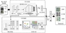
图1
本文方法整体流程"

表1
VGG-19卷积层结构信息"
| 组别 | 卷积层数目 | 特征尺寸 |
|---|---|---|
| conv1 | 2 | 64×224×224 |
| conv2 | 2 | 128×112×112 |
| conv3 | 4 | 256×56×56 |
| conv4 | 4 | 512×28×28 |
| conv5 | 4 | 512×14×14 |
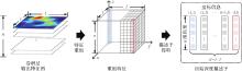
图2
初始描述子提取过程"
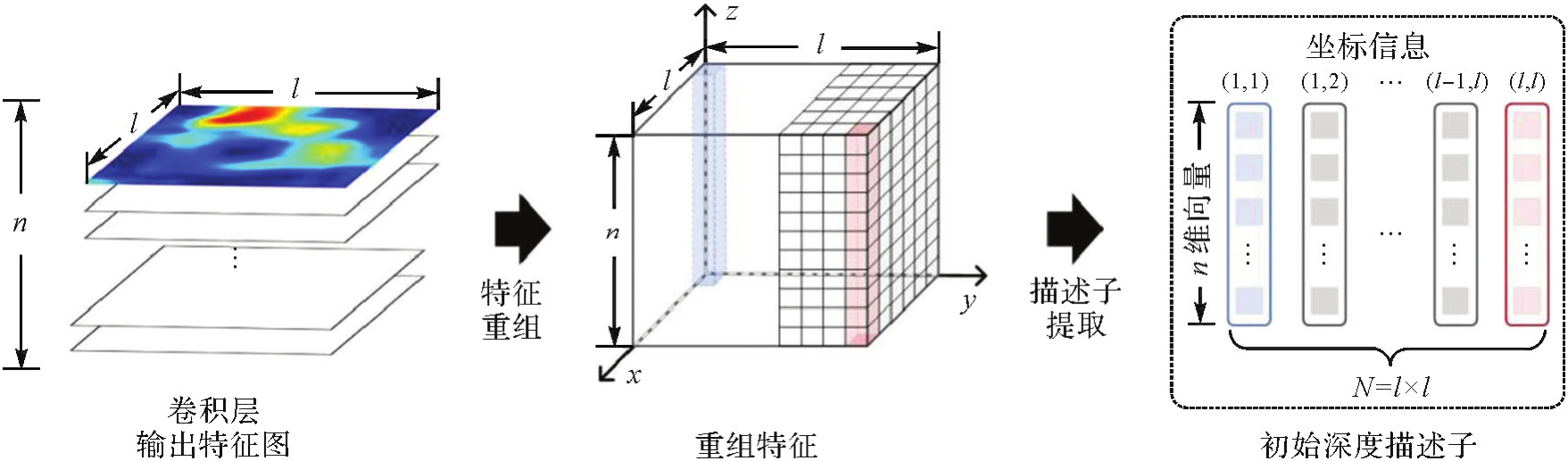
图3
满足空间距离约束的局部深度描述子匹配对数目统计"
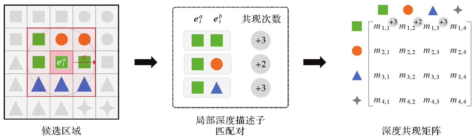
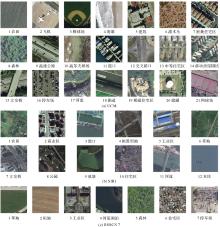
图4
试验遥感影像场景数据集"
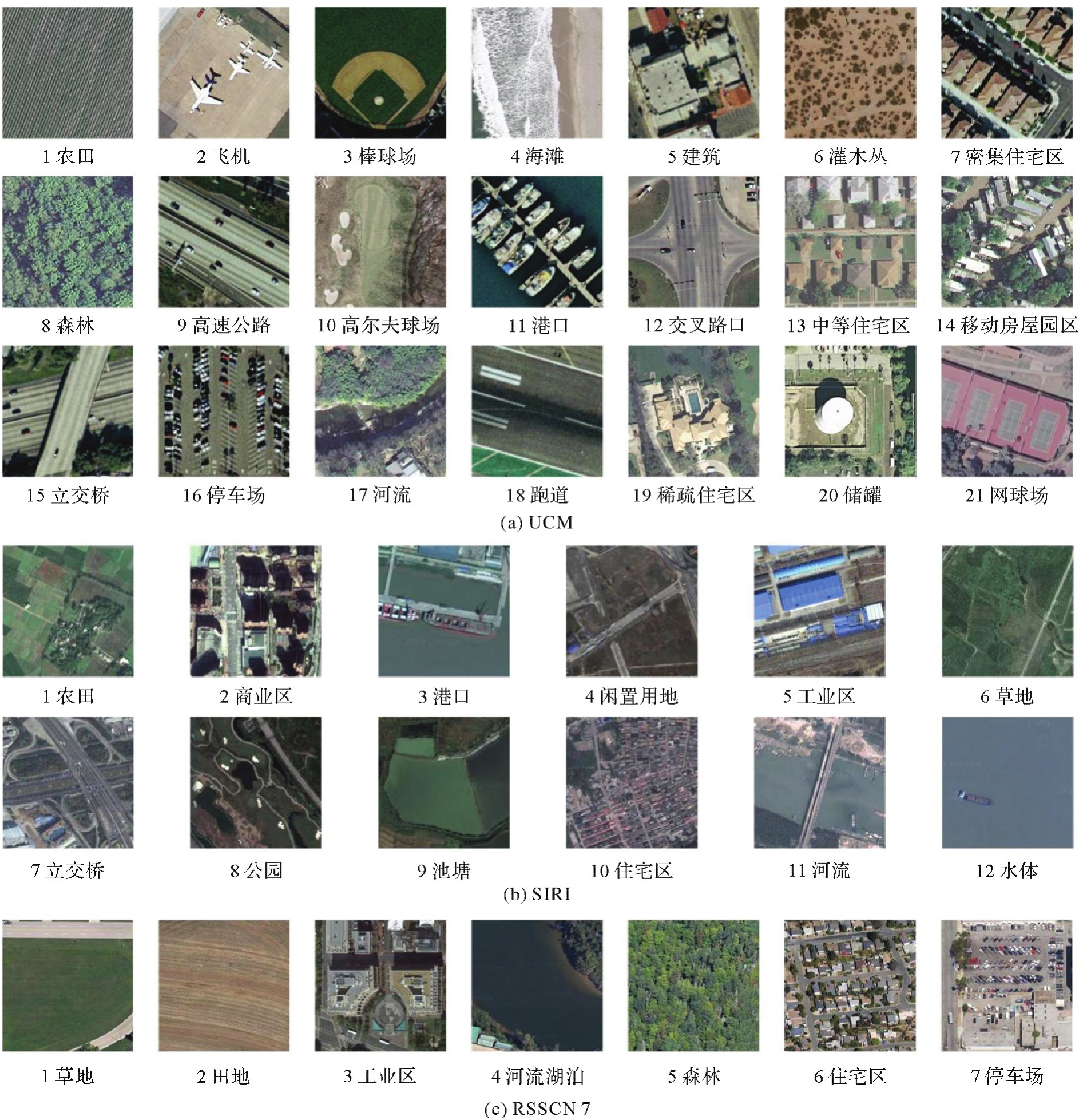
表2
试验数据集参数信息"
| 数据集 | 场景尺寸 | 场景数目 | 训练样本占比/(%) |
|---|---|---|---|
| UCM | 256像素×256像素 | 2100 | 80 |
| SIRI | 200像素×200像素 | 2400 | 80 |
| RSSCN7 | 400像素×400像素 | 2800 | 50 |
表3
空间特征试验参数信息"
| 卷积层 | r值 | K值 |
|---|---|---|
| conv4:conv4_1、conv4_2、conv4_3、conv4_4 | 2、4、6、8、10、12、14 | UCM:50、200、400、600、800、1000、1200、1400、1600、1800、2000 |
| conv5:conv5_1、conv5_2、conv5_3、conv5_4 | 1、2、3、4、5、6、7 | SIRI:50、100、200、300、400、500、600、700、800、900、1000 |
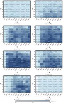
图5
空间特征在UCM数据集上采用不同参数的分类结果"

图6
空间特征在SIRI数据集上采用不同参数的分类结果"

表4
空间特征与经典特征分类结果"
| 分类特征 | 准确率 | |
|---|---|---|
| UCM | SIRI | |
| 方向梯度直方图特征 | 52.14 | 44.79 |
| 尺度不变特征变换特征 | 58.33 | 53.96 |
| 局部二值模式特征 | 31.43 | 46.25 |
| SIFT+BoVW | 76.81 | 75.63 |
| VGG-19卷积层级联深度特征[ | 93.33 | 93.48 |
| 空间特征的Min-acc | 84.01 | 84.79 |
| 空间特征的Mid-acc | 95.47 | 94.38 |
| 空间特征的Max-acc | 98.33 | 96.25 |
图7
不同卷积层特征所得空间特征准确率对比"

表5
K值范围设定"
| 数据集 | Low_K | Mid_K | High_K |
|---|---|---|---|
| UCM | {400,600,800} | {1000,1200,1400} | {1600,1800,2000} |
| SIRI | {200,300,400} | {500,600,700} | {800,900,1000} |
表6
UCM数据集上不同K值下空间特征的平均准确率对比"
| 卷积层 | r值 | 不同K值下的平均准确率/(%) | ||
|---|---|---|---|---|
| Low_K | Mid_K | High_K | ||
| conv4 | 2 | 95.25 | 95.57 | 95.39 |
| 4 | 95.65 | 95.84 | 95.70 | |
| 6 | 96.05 | 96.15 | 96.13 | |
| 8 | 96.08 | 96.39 | 96.47 | |
| 10 | 96.37 | 96.69 | 96.47 | |
| 12 | 96.63 | 96.74 | 96.66 | |
| 14 | 96.66 | 96.76 | 96.84 | |
| 均值 | 96.10 | 96.31 | 96.24 | |
| conv5 | 1 | 94.94 | 95.36 | 94.62 |
| 2 | 95.58 | 96.00 | 95.60 | |
| 3 | 95.56 | 96.50 | 96.08 | |
| 4 | 96.12 | 96.95 | 96.58 | |
| 5 | 96.28 | 97.48 | 97.22 | |
| 6 | 96.48 | 97.37 | 97.19 | |
| 7 | 96.38 | 97.27 | 97.19 | |
| 均值 | 95.91 | 96.70 | 96.35 | |
表7
SIRI数据集上不同K值下空间特征的平均准确率对比"
| 卷积层 | r值 | 不同K值下的平均准确率/(%) | ||
|---|---|---|---|---|
| Low_K | Mid_K | High_K | ||
| conv4 | 2 | 94.41 | 94.29 | 94.22 |
| 4 | 94.48 | 94.55 | 94.44 | |
| 6 | 94.86 | 94.72 | 94.62 | |
| 8 | 94.91 | 95.09 | 94.88 | |
| 10 | 94.97 | 95.30 | 95.09 | |
| 12 | 95.00 | 95.30 | 95.24 | |
| 14 | 95.19 | 95.28 | 95.43 | |
| 均值 | 94.83 | 94.93 | 94.85 | |
| conv5 | 1 | 92.95 | 93.13 | 93.09 |
| 2 | 93.46 | 93.44 | 93.65 | |
| 3 | 93.31 | 94.17 | 94.13 | |
| 4 | 93.49 | 94.41 | 94.44 | |
| 5 | 93.15 | 94.34 | 94.31 | |
| 6 | 93.49 | 94.48 | 94.41 | |
| 7 | 93.46 | 94.31 | 94.65 | |
| 均值 | 93.33 | 94.04 | 94.10 | |
图8
不同K值下聚类时间耗费"
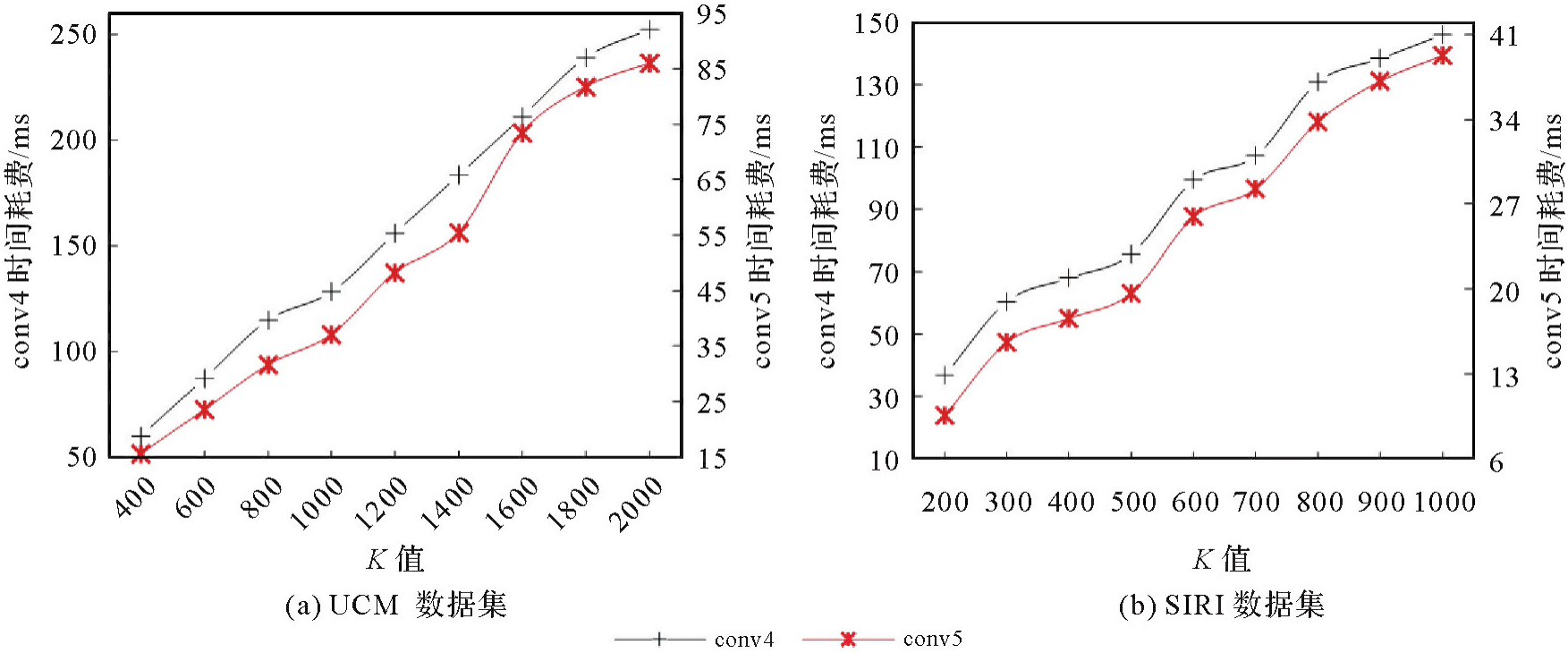
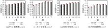
图9
空间特征在UCM、SIRI数据集上采用不同r值时的准确率"

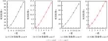
图10
不同r值下计算深度空间共现矩阵时间耗费"
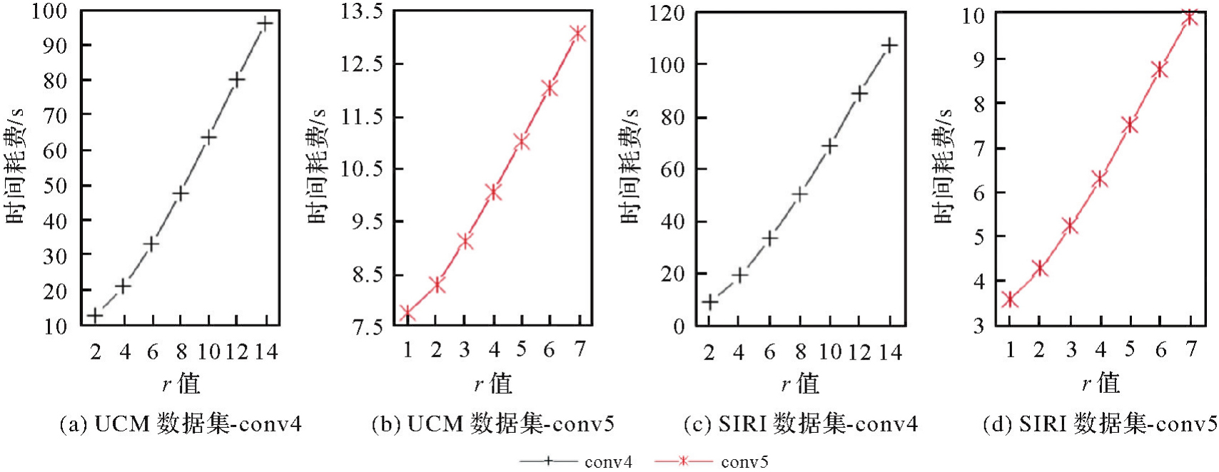
表8
语义特征、空间特征和联合特征的表现对比"
| 特征 | 准确率 | ||
|---|---|---|---|
| UCM | SIRI | RSSCN7 | |
| 语义特征G | 95.00 | 93.75 | 86.35 |
| 空间特征F | 98.33 | 96.25 | 92.78 |
| 联合特征z | 98.81 | 97.08 | 93.71 |
表9
UCM数据集上分类结果"
| 方法 | 准确率 |
|---|---|
| RF[ | 44.77 |
| SIFT+BoVW[ | 76.81 |
| SIFT+SPCK[ | 77.38 |
| VGG-19(从头训练) | 83.48 |
| JMCNN[ | 89.30 |
| 预训练VGG-19特征+SVM | 94.29 |
| GLDFB[ | 97.62 |
| TLMoE-VGG19[ | 98.10 |
| 本文方法 | 98.81 |
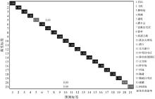
图11
UCM数据集分类混淆矩阵"
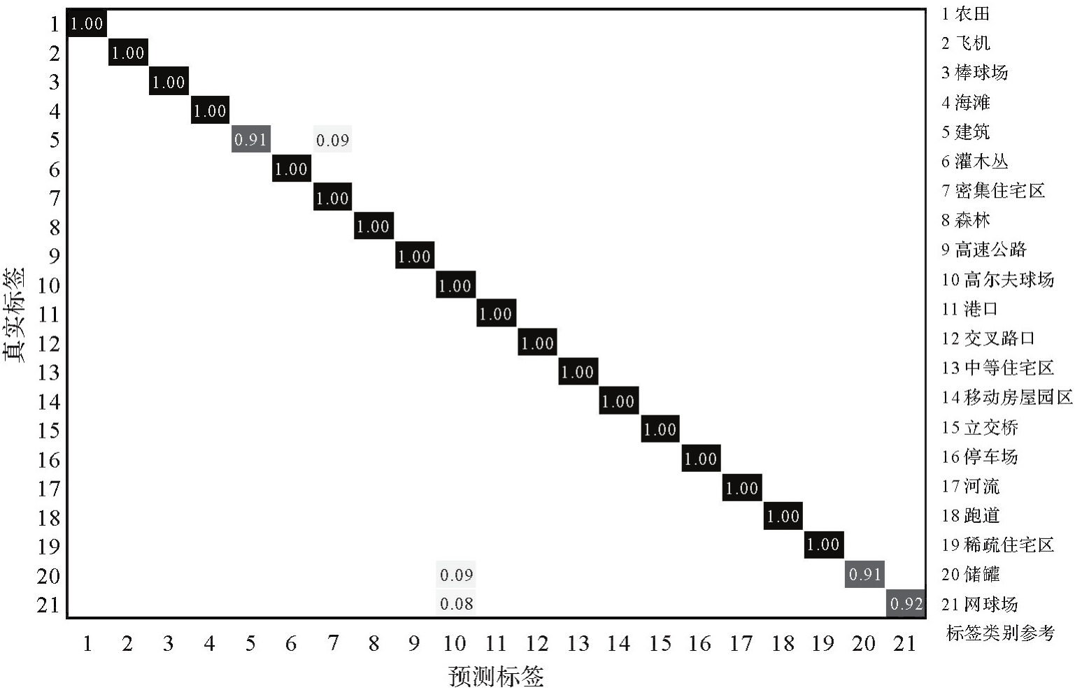
表10
SIRI数据集上分类结果"
| 方法 | 准确率 |
|---|---|
| RF[ | 49.90 |
| SIFT+BoVW[ | 75.63 |
| SIFT+SPMK[ | 77.69±1.01 |
| VGG-19(从头训练) | 86.13 |
| 预训练VGG-19特征+SVM | 94.79 |
| GLDFB[ | 96.67 |
| ADC-CPANet[ | 96.04 |
| LAG-MANet[ | 97.04 |
| 本文方法 | 97.08 |
图12
SIRI数据集分类混淆矩阵"
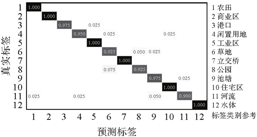
表11
RSSCN7数据集上分类结果"
| 方法 | 准确率 |
|---|---|
| RF[ | 55.43 |
| VGG-19(从头训练) | 82.50 |
| MECo-2-2[ | 86.67 |
| bank[ | 90.04±0.60 |
| 预训练VGG-19特征+SVM | 91.93 |
| TLMoE-VGG19[ | 93.21 |
| Dual Attention-Aware Network[ | 93.25±0.28 |
| 本文方法 | 93.71 |
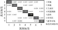
图13
RSSCN7数据集分类混淆矩阵"
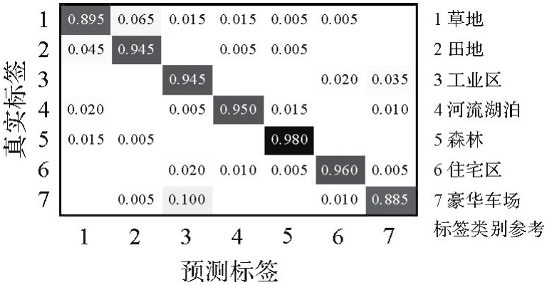
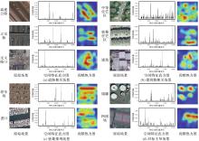
图14
不同场景空间特征及场景空间共现关系贡献情况可视化"

表12
本文方法在UCM数据集上采用其他预训练网络的分类结果"
| 预训练网络 | 空间特征提取层 | 准确率 | ||
|---|---|---|---|---|
| 语义特征 | 空间特征 | 联合特征 | ||
| Alexnet[ | conv4 | 93.33 | 95.48 | 97.14 |
| Goog LeNet[ | inception4d | 93.81 | 96.67 | 97.38 |
| VGG16[ | conv4_2 | 95.47 | 97.14 | 97.62 |
| Resnet18[ | Res3a | 96.19 | 96.91 | 98.09 |
| Resnet50[ | Res3a | 96.91 | 97.85 | 98.33 |
| Resnet101[ | Res3a | 96.66 | 97.14 | 98.09 |
| DenseNet[ | denseblock3 | 97.62 | 97.85 | 98.57 |
| ShuffleNet[ | stage4 | 96.17 | 96.43 | 97.62 |
表13
本文方法在NWPU-RESISC45数据集上采用不同预训练模型的分类结果"
| 预训练模型 | 训练集占比10% | 训练集占比20% | ||
|---|---|---|---|---|
| 原始模型准确率 | 本文方法准确率 | 原始模型准确率 | 本文方法准确率 | |
| Alexnet[ | 81.98 | 82.64 | 85.73 | 86.48 |
| VGG16[ | 87.20 | 88.15 | 90.12 | 91.20 |
| VGG19[ | 87.53 | 88.33 | 90.75 | 91.46 |
| Resnet50[ | 89.78 | 90.55 | 92.41 | 92.72 |
| DenseNet[ | 90.17 | 90.46 | 92.32 | 92.75 |
| ShuffleNet[ | 84.23 | 85.25 | 88.70 | 89.04 |
| JMCNN[ | 56.44 | 57.02 | 65.57 | 66.44 |
| MF2CNet[ | 92.07 | 92.60 | 93.85 | 93.99 |
| EMTCAL[ | 91.63 | 92.51 | 93.65 | 94.35 |
| [1] | ROWLEY J. The wisdom hierarchy: representations of the DIKW hierarchy[J]. Journal of Information Science, 2007, 33(2): 163-180. |
| [2] | 郑卓, 方芳, 刘袁缘, 等. 高分辨率遥感影像场景的多尺度神经网络分类法[J]. 测绘学报, 2018, 47(5): 620-630. DOI: 10.11947/j.AGCS.2018.20170191. |
| ZHENG Zhuo, FANG Fang, LIU Yuanyuan, et al. Joint multi-scale convolution neural network for scene classification of high resolution remote sensing imagery[J]. Acta Geodaetica et Cartographica Sinica, 2018, 47(5): 620-630. DOI: 10.11947/j.AGCS.2018.20170191. | |
| [3] | 李彦胜, 吴敏郎, 张永军. 知识图谱约束深度网络的高分辨率遥感影像场景分类[J]. 测绘学报, 2024, 53(4): 677-688. DOI: 10.11947/j.AGCS.2024.20230125. |
| LI Yansheng, WU Minlang, ZHANG Yongjun. Knowledge graph-guided deep network for high-resolution remote sensing image scene classification[J]. Acta Geodaetica et Cartographica Sinica, 2024, 53(4): 677-688. DOI: 10.11947/j.AGCS.2024.20230125. | |
| [4] | LI Yansheng, WU Yuning, CHENG Gong, et al. MEET: a million-scale dataset for fine-grained geospatial scene classification with zoom-free remote sensing imagery[J]. CAA Journal of Automatica Sinica, 2025, 12(5): 1004-1023. |
| [5] | HU Fan, XIA Guisong, HU Jingwen, et al. Transferring deep convolutional neural networks for the scene classification of high-resolution remote sensing imagery[J]. Remote Sensing, 2015, 7(11): 14680-14707. |
| [6] | NOGUEIRA K, PENATTI O A B, DOS SANTOS J A. Towards better exploiting convolutional neural networks for remote sensing scene classification[J]. Pattern Recognition, 2017, 61: 539-556. |
| [7] | CASTELLUCCIO M, POGGI G, SANSONE C, et al. Land use classification in remote sensing images by convolutional neural networks[J]. Acta Ecologica Sinica, 2015, 28(2): 627-635. |
| [8] | ZHOU Weixun, SHAO Zhenfeng, CHENG Qimin. Deep feature representations for high-resolution remote sensing scene classification[C]//Proceedings of 2016 International Workshop on Earth Observation and Remote Sensing Applications. Guangzhou: IEEE, 2016: 338-342. |
| [9] | CHAIB S, LIU Huan, GU Yanfeng, et al. Deep feature fusion for VHR remote sensing scene classification[J]. IEEE Transactions on Geoscience and Remote Sensing, 2017, 55(8): 4775-4784. |
| [10] | ÖZYURT F. Efficient deep feature selection for remote sensing image recognition with fused deep learning architectures[J]. The Journal of Supercomputing, 2020, 76: 8413-8431. |
| [11] | PENATTI O A B, NOGUEIRA K, DOS SANTOS J A. Do deep features generalize from everyday objects to remote sensing and aerial scenes domains?[C]//Proceedings of 2015 IEEE Conference on Computer Vision and Pattern Recognition Workshops. Boston: IEEE, 2015: 44-51. |
| [12] | YANDEX A B, LEMPITSKY V. Aggregating local deep features for image retrieval[C]//Proceedings of 2015 IEEE International Conference on Computer Vision. Santiago: IEEE, 2015: 1269-1277. |
| [13] | CSURKA G, DANCEC R, FAN L X, et al. Visual categorization with bags of keypoints[C]//Proceedings of 2014 Workshop on Statistical Learning in Computer Vision. Zurich: Springer, 2014: 1-22. |
| [14] | JEGOU H, DOUZE M, SCHMID C, et al. Aggregating local descriptors into a compact image representation[C]//Proceedings of 2010 IEEE Computer Society Conference on Computer Vision and Pattern Recognition. San Francisco: IEEE, 2010: 3304-3311. |
| [15] | WANG Jinjun, YANG Jianchao, YU Kai, et al. Locality-constrained linear coding for image classification[C]//Proceedings of 2010 IEEE Computer Society Conference on Computer Vision and Pattern Recognition. San Francisco: IEEE, 2010: 3360-3367. |
| [16] | 龚希, 吴亮, 谢忠, 等. 融合全局和局部深度特征的高分辨率遥感影像场景分类方法[J]. 光学学报, 2019, 39(3): 19-29. |
| GONG Xi, WU Liang, XIE Zhong, et al. Classification method of high-resolution remote sensing scenes based on fusion of global and local deep features[J]. Acta Optica Sinica, 2019, 39(3): 19-29. | |
| [17] | BRATASANU D, NEDELCU I, DATCU M. Bridging the semantic gap for satellite image annotation and automatic mapping applications[J]. IEEE Journal of Selected Topics in Applied Earth Observations and Remote Sensing, 2011, 4(1): 193-204. |
| [18] | LAZEBNIK S, SCHMID C, PONCE J. Beyond bags of features: spatial pyramid matching for recognizing natural scene categories[C]//Proceedings of 2006 IEEE Computer Society Conference on Computer Vision and Pattern Recognition. New York: IEEE, 2006: 2169-2178. |
| [19] | YANG Yi, NEWSAM S. Spatial pyramid co-occurrence for image classification[C]//Proceedings of 2011 International Conference on Computer Vision. Barcelona: IEEE, 2011: 1465-1472. |
| [20] | SIMONYAN K, ZISSERMAN A. Very deep convolutional networks for large scale image recognition[EB/OL]. [2025-05-08]. https://arxiv.org/abs/1409.1556. |
| [21] | 龚希, 陈占龙, 吴亮, 等. 用于高分辨遥感影像场景分类的迁移学习混合专家分类模型[J]. 光学学报, 2021, 41(23): 19-31. |
| GONG Xi, CHEN Zhanlong, WU Liang, et al. Transfer learning based mixture of experts classification model for high-resolution remote sensing scene classification[J]. Acta Optica Sinica, 2021, 41(23): 19-31. | |
| [22] | BREIMAN L. Random forests[J]. Machine Learning, 2001, 45(1): 5-32. |
| [23] | 王威, 李希杰, 王新. ADC-CPANet:一种局部—全局特征融合的遥感图像分类方法[J]. 遥感学报, 2024, 28(10): 2661-2672. |
| WANG Wei, LI Xijie, WANG Xin. ADC-CPANet: a remote sensing image classification method based on local-global feature fusion[J]. National Remote Sensing Bulletin, 2024, 28(10): 2661-2672. | |
| [24] | 王威, 郑薇, 王新. 面向遥感图像场景分类的LAG-MANet模型[J]. 测绘学报, 2024, 53(7): 1371-1383. DOI: 10.11947/j.AGCS.2024.20230074. |
| WANG Wei, ZHENG Wei, WANG Xin. LAG-MANet model for remote sensing image scene classification[J]. Acta Geodaetica et Cartographica Sinica, 2024, 53(7): 1371-1383. DOI: 10.11947/j.AGCS.2024.20230074. | |
| [25] | XU Yin, GUO Weiwei, ZHANG Zenghui, et al. Multiple embeddings contrastive pretraining for remote sensing image classification[J]. IEEE Geoscience and Remote Sensing Letters, 2022, 19(6): 451060501-451060505. |
| [26] | WU Hang, LIU Baozhen, SU Weihua, et al. Deep filter banks for land-use scene classification[J]. IEEE Geoscience and Remote Sensing Letters, 2016, 13(12): 1895-1899. |
| [27] | GAO Yue, SHI Jun, LI Jun, et al. Remote sensing scene classification with dual attention-aware network[C]//Proceedings of 2020 IEEE International Conference on Image, Vision and Computing. Beijing: IEEE, 2020: 171-175. |
| [28] | KRIZHEVSKY A, SUTSKEVER I, HINTON G E. ImageNet classification with deep convolutional neural networks[C]//Proceedings of 2012 International Conference on Neural Information Processing Systems. Lake Tahoe: NIPS, 2012: 1097-1105. |
| [29] | SZEGEDY C, LIU Wei, JIA Yangqing, et al. Going deeper with convolutions[C]//Proceedings of 2015 IEEE Conference on Computer Vision and Pattern Recognition. Boston: IEEE, 2015: 1-9. |
| [30] | HE Kaiming, ZHANG Xiangyu, REN Shaoqing, et al. Deep residual learning for image recognition[C]//Proceedings of 2016 IEEE Conference on Computer Vision and Pattern Recognition. Las Vega: IEEE, 2016: 770-778. |
| [31] | HUANG Gao, LIU Zhuang, VAN DER MAATEN L, et al. Densely connected convolutional networks[C]//Proceedings of 2017 IEEE Conference on Computer Vision and Pattern Recognition. Honolulu: IEEE, 2017: 2261-2269. |
| [32] | ZHANG Xiangyu, ZHOU Xinyu, LIN Mengxiao, et al. ShuffleNet: an extremely efficient convolutional neural network for mobile devices[C]//Proceedings of 2018 IEEE/CVF Conference on Computer Vision and Pattern Recognition. Salt Lake City: IEEE, 2018: 6848-6856. |
| [33] | BAI Lin, LIU Qingxin, LI Cuiling, et al. Remote sensing image scene classification using multiscale feature fusion covariance network with octave convolution[J]. IEEE Transactions on Geoscience and Remote Sensing, 2022, 60: 5620214. |
| [34] | TANG Xu, LI Mingteng, MA Jingjing, et al. EMTCAL: efficient multiscale transformer and cross-level attention learning for remote sensing scene classification[J]. IEEE Transactions on Geoscience and Remote Sensing, 2022, 60: 5626915. |
| [1] | 吴岚昕, 彭江涛, 孙伟伟, 杨冰. 面向海岸带湿地高光谱遥感的欧拉映射与互补特征建模变化检测方法[J]. 测绘学报, 2026, 55(4): 618-631. |
| [2] | 季顺平, 刘瑾, 高建, 龚健雅. 多视影像深度学习密集匹配三维重建智能框架[J]. 测绘学报, 2025, 54(9): 1633-1646. |
| [3] | 谢亚坤, 赵耀纪, 涂佳星, 夏瑞丰, 冯德俊, 刘苏凝, 陈虹宇, 朱军. 融合边缘与全局特征的遥感影像显著性目标检测方法[J]. 测绘学报, 2025, 54(7): 1265-1279. |
| [4] | 董子博, 王竞雪, 卜丽静, 房琳, 许峥辉. MAFNet:基于多尺度空洞融合网络的遥感影像建筑物提取方法[J]. 测绘学报, 2025, 54(6): 1094-1106. |
| [5] | 李海峰, 郭旺, 吴梦伟, 彭程里, 朱庆, 刘瑜, 陶超. 视觉-语言联合的遥感地物概念表达与智能解译:原理、挑战与机遇[J]. 测绘学报, 2025, 54(5): 853-872. |
| [6] | 王超, 陈天宇, 张同, AhmedTanvir, 纪立强, 谢涛, 杨佳俊, 王帅. 基于全局差分增强模块和平衡惩罚损失的多源光学遥感影像变化检测[J]. 测绘学报, 2025, 54(5): 873-887. |
| [7] | 赵一鸣, 胡克林, 涂可龙, 卿雅娴, 杨超, 祁昆仑, 吴华意. 基于SAR与光学遥感影像融合的多标签场景分类方法[J]. 测绘学报, 2025, 54(5): 911-923. |
| [8] | 张新长, 齐霁, 陶超, 傅思扬, 郭明宁, 阮永检. 光学遥感影像去云研究进展、挑战与趋势[J]. 测绘学报, 2025, 54(4): 603-620. |
| [9] | 侯昭阳, 闫浩文, 张黎明, 马荣娟, 屈睿涛. 基于耦合神经P系统与区块链的遥感影像零水印版权保护方法[J]. 测绘学报, 2025, 54(12): 2247-2261. |
| [10] | 张志力, 姜慧伟, 胡翔云. 面向极简交互的遥感地物精确批量提取框架[J]. 测绘学报, 2025, 54(10): 1863-1876. |
| [11] | 龚良雄, 李星华, 程远明, 赵兴友, 谢仁平, 王红根. 时空差异增强与自适应特征融合的轻量级遥感影像变化检测网络[J]. 测绘学报, 2025, 54(1): 136-153. |
| [12] | 李佳铃, 齐霁, 鲁伟鹏, 陶超. 面向城市功能区分类的光学遥感影像-OSM数据联合自监督学习方法[J]. 测绘学报, 2025, 54(1): 154-164. |
| [13] | 鄢薪, 慎利, 潘俊杰, 戴延帅, 王继成, 郑晓莉, 李志林. 多尺度特征融合与空间优化的弱监督高分遥感建筑变化检测[J]. 测绘学报, 2024, 53(8): 1586-1597. |
| [14] | 谢志伟, 翟帅智, 张丰源, 陈旻, 孙立双. 面向对象高分影像归纳式图神经网络分类法[J]. 测绘学报, 2024, 53(8): 1610-1623. |
| [15] | 王威, 郑薇, 王新. 面向遥感图像场景分类的LAG-MANet模型[J]. 测绘学报, 2024, 53(7): 1371-1383. |
| 阅读次数 | ||||||
|
全文 |
|
|||||
|
摘要 |
|
|||||