


测绘学报 ›› 2025, Vol. 54 ›› Issue (6): 967-981.doi: 10.11947/j.AGCS.2025.20240409
• 综述 • 下一篇
吴华意1,2( ), 董广胜1,2(), 李锐1,2
收稿日期:2024-09-30
修回日期:2025-05-12
出版日期:2025-07-14
发布日期:2025-07-14
通讯作者:
董广胜
E-mail:wuhuayi@whu.edu.cn;guangshengdong@whu.edu.cn
作者简介:吴华意(1966—),男,博士,教授,研究方向为地理信息服务、分析和挖掘。E-mail:wuhuayi@whu.edu.cn
基金资助:
Huayi WU1,2(), Guangsheng DONG1,2(), Rui LI1,2
Received:2024-09-30
Revised:2025-05-12
Online:2025-07-14
Published:2025-07-14
Contact:
Guangsheng DONG
E-mail:wuhuayi@whu.edu.cn;guangshengdong@whu.edu.cn
About author:WU Huayi (1966—), male, PhD, professor, majors in geographic information service, analysis and mining. E-mail: wuhuayi@whu.edu.cn
Supported by:摘要:
人与虚拟空间的时空交互过程形成了虚拟轨迹。虚拟轨迹为研究人与虚拟/物理空间的关系提供了新的视角。公共地图服务平台作为一种应用最为广泛的虚拟空间,其空间基准与物理空间一致,该空间下的虚拟轨迹蕴含了人的兴趣偏好,能够预示物理空间中潜在的空间交互倾向,是当前主流研究对象。然而,虚拟轨迹的概念特征和研究框架尚未确立,阻碍了虚拟轨迹研究的发展。本文定义了该空间下虚拟轨迹的基本概念,分析了虚拟轨迹的多尺度、不确定性特征,从表达建模和分析挖掘角度提出了虚拟轨迹研究框架。表达建模方法包括时序降噪、空间降维、空间分割的时空表达,基于目标点识别与筛选的路径还原,以及结合空间共现和语义匹配的语义还原。分析挖掘体系梳理了领域分类、主题聚类、动态演化等个体模式研究方向,以及时空分布规律、时空分布预测、虚实关联模式等群体模式研究现状。在理论基础、技术体系、空间语义、开源数据、应用场景方面探讨未来的研究方向,本文所构建的虚拟轨迹研究框架也将成为理解人在虚拟空间中空间活动规律的新范式。
中图分类号:
吴华意, 董广胜, 李锐. 虚拟轨迹:概念特征和研究框架[J]. 测绘学报, 2025, 54(6): 967-981.
Huayi WU, Guangsheng DONG, Rui LI. Virtual trajectories: conceptual characteristics and research framework[J]. Acta Geodaetica et Cartographica Sinica, 2025, 54(6): 967-981.
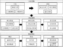
图1
虚拟轨迹研究框架"
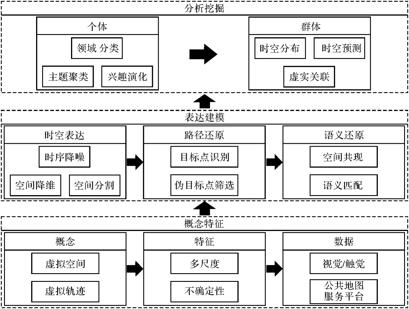

图2
公共地图服务平台中的金字塔模型与虚拟轨迹[27]"
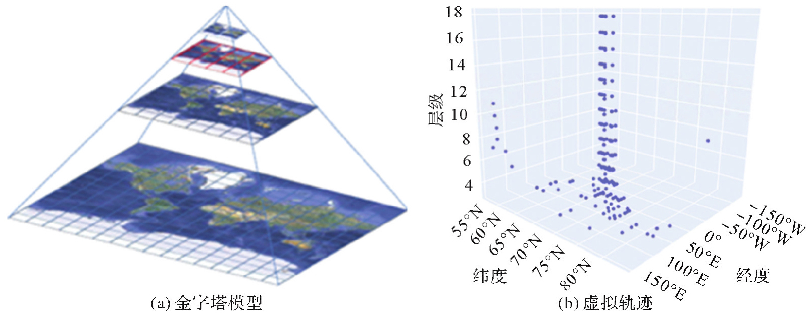
图3
虚拟轨迹空间降维"
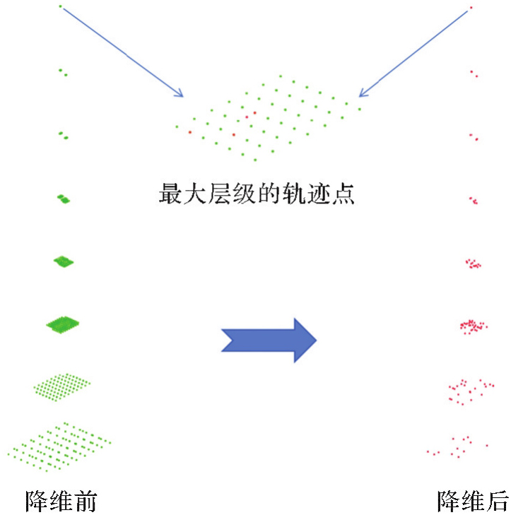

图4
复杂虚拟轨迹空间分割[25]"


图5
虚拟轨迹的目标点"
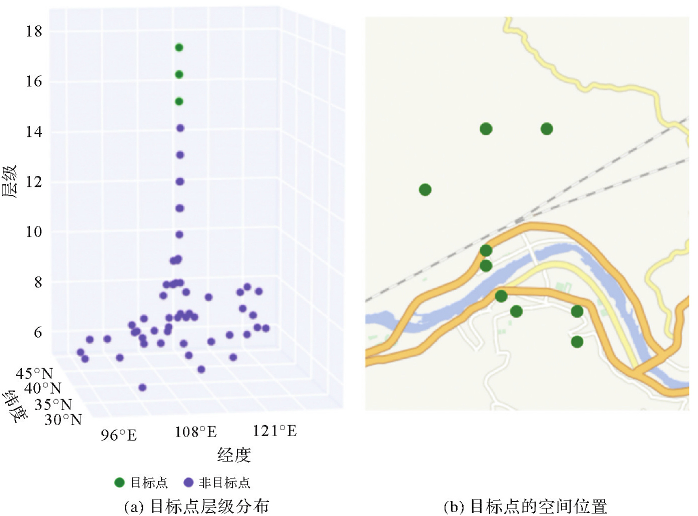

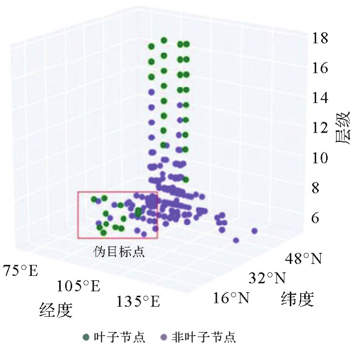
图6
轨迹生成树中低层级分布的伪目标点[27]"
| [1] | 周成虎. 地理学赋能网络空间认知[J]. 科技导报, 2023, 41(13): 1. |
| ZHOU Chenghu. Enabling cyberspace cognition with geography[J]. Science & Technology Review, 2023, 41(13): 1. | |
| [2] | 高春东, 郭启全, 江东, 等. 网络空间地理学的理论基础与技术路径[J]. 地理学报, 2019, 74(9): 1709-1722. |
| GAO Chundong, GUO Qiquan, JIANG Dong, et al. The theoretical basis and technical path of cyberspace geography[J]. Acta Geographica Sinica, 2019, 74(9): 1709-1722. | |
| [3] | 江东, 高春东, 郭启全, 等. 论网络空间的地理属性与地理学思维[J]. 地球信息科学学报, 2023, 25(10): 1923-1932. |
| JIANG Dong, GAO Chundong, GUO Qiquan, et al. Geographical properties and thinking of cyberspace[J]. Journal of Geo-information Science, 2023, 25(10): 1923-1932. | |
| [4] | 唐炉亮, 戴领, 任畅, 等. 现实与赛博空间数据相结合的城市活动事件时空建模[J]. 测绘学报, 2019, 48(5): 618-629. |
| TANG Luliang, DAI Ling, REN Chang, et al. Spatio-temporal modeling of city events combining datasets in cyberspace and real space[J]. Acta Geodaetica et Cartographica Sinica, 2019, 48(5): 618-629. | |
| [5] | 陈云海. 社交网络空间时空实体建模与可视化研究[D]. 郑州: 信息工程大学, 2022. |
| CHEN Yunhai. Research on modeling and visualization methods of social cyberspace spatio-temporal entities[D]. Zhengzhou: Information Engineering University, 2022. | |
| [6] | 陈文静, 李锐, 董广胜, 等. 网络地理信息服务中用户空间访问聚集行为研究[J]. 地球信息科学学报, 2021, 23(1): 93-103. |
| CHEN Wenjing, LI Rui, DONG Guangsheng, et al. Research on user spatial access aggregation behavior in network geographic information service[J]. Journal of Geo-information Science, 2021, 23(1): 93-103. | |
| [7] | CHEN Min, CLARAMUNT C, ÇÖLTEKIN A, et al. Artificial intelligence and visual analytics in geographical space and cyberspace: research opportunities and challenges[J]. Earth-Science Reviews, 2023, 241: 104438. |
| [8] | 董广胜, 谢文析, 李锐, 等. 新型冠状病毒感染疫情政策干预下群体虚拟轨迹时空模式差异性研究[J]. 时空信息学报, 2024, 31(1): 104-117. |
| DONG Guangsheng, XIE Wenxi, LI Rui, et al. Study on the spatiotemporal pattern differences of group virtual trajectories under COVID-19 policy interventions[J]. Journal of Spatio-Temporal Information, 2024, 31(1): 104-117. | |
| [9] | 王继龙, 庄姝颖, 缪葱葱, 等. 网络空间信息系统模型与应用[J]. 通信学报, 2020, 41(2): 74-83. |
| WANG Jilong, ZHUANG Shuying, MIAO Congcong, et al. Model and application of cyberspace information system[J]. Journal on Communications, 2020, 41(2): 74-83. | |
| [10] | 董广胜. 公共地图服务平台中访问兴趣时空模式研究[J]. 测绘学报, 2023, 52(10): 1798. |
| DONG Guangsheng. Spatio-temporal pattern mining for users' access interest on public map service platforms[J]. Acta Geodaetica et Cartographica Sinica, 2023, 52(10): 1798. | |
| [11] | 周侗, 龙毅. 我国近期移动地图与互联网地图发展综述[J]. 地理与地理信息科学, 2012, 28(5): 1-5. |
| ZHOU Tong, LONG Yi. Review about recently development of mobile map and internet map in China[J]. Geography and Geo-Information Science, 2012, 28(5): 1-5. | |
| [12] | 张得天, 王佳傲, 陈飞. 国内网络地图服务比较分析研究[J]. 华东师范大学学报(自然科学版), 2017(6): 85-95. |
| ZHANG Detian, WANG Jia'ao, CHEN Fei. A comprehensive study of mapping services in China[J]. Journal of East China Normal University (Natural Science), 2017(6): 85-95. | |
| [13] |
蒋捷, 吴华意, 黄蔚. 国家地理信息公共服务平台“天地图”的关键技术与工程实践[J]. 测绘学报, 2017, 46(10): 1665-1671. DOI: .
doi: 10.11947/j.AGCS.2017.20170357 |
|
JIANG Jie, WU Huayi, HUANG Wei. Key techniques and project practice for establishing national geo-information service platform “Tianditu”[J]. Acta Geodaetica et Cartographica Sinica, 2017, 46(10): 1665-1671. DOI: .
doi: 10.11947/j.AGCS.2017.20170357 |
|
| [14] | 陈欣, 向隆刚, 焦凤伟. 基于众源轨迹的OSM路网转向信息增强[J]. 地球信息科学学报, 2023, 25(10): 1954-1967. |
| CHEN Xin, XIANG Longgang, JIAO Fengwei. Turning information enhancement of OpenStreetMap road network based on crowdsourcing trajectory data[J]. Journal of Geo-information Science, 2023, 25(10): 1954-1967. | |
| [15] | ZHAO Zhiyao, FAN Hongchao. Towards exploring patterns of editing behavior on OpenStreetMap[J]. Journal of Geodesy and Geoinformation Science, 2022, 5(2): 85-97. |
| [16] | BALLATORE A, ARSANJANI J J. Placing Wikimapia: an exploratory analysis[J]. International Journal of Geographical Information Science, 2019, 33(8): 1633-1650. |
| [17] | DONG Guangsheng, LI Rui, WU Huayi, et al. Browsing behavior modeling and browsing interest extraction in the trajectories on web map service platforms[J]. Expert Systems with Applications, 2022, 195: 116590. |
| [18] | 陈迪, 张鹏, 杨洁艳, 等. 在线地图服务日志的大数据分析[J]. 小型微型计算机系统, 2015, 36(1): 33-38. |
| CHEN Di, ZHANG Peng, YANG Jieyan, et al. Big data analysis of web map service log[J]. Journal of Chinese Computer Systems, 2015, 36(1): 33-38. | |
| [19] | 李锐, 沈雨奇, 蒋捷, 等. 公共地图服务中访问热点区域的时空规律挖掘[J]. 武汉大学学报(信息科学版), 2018, 43(9): 1408-1415. |
| LI Rui, SHEN Yuqi, JIANG Jie, et al. Temporal and spatial characteristics of hotspots in public map service[J]. Geomatics and Information Science of Wuhan University, 2018, 43(9): 1408-1415. | |
| [20] | WANG Xiaofei, CHEN Di, LU Gan, et al. Web map service log analysis[C]//Proceedings of 2014 Wireless Algorithms, Systems, and Applications. Harbin: Springer, 2014: 22-33. |
| [21] | 李茹, 李锐, 蒋捷, 等. 网络地图用户访问会话时空特征分析[J]. 数据分析与知识发现, 2019(6): 1-11. |
| LI Ru, LI Rui, JIANG Jie, et al. Spatio-temporal characteristics of WMTS access sessions[J]. Data Analysis and Knowledge Discovery, 2019(6): 1-11. | |
| [22] | XIAO Xiangye, LUO Qiong, LI Zhisheng, et al. A large-scale study on map search logs[J]. ACM Transactions on the Web, 2010, 4(3): 1-33. |
| [23] | BRAGA V G, OLIVEIRA W B D, RODRIGUES V J, et al. Understanding and modeling the behavior of web map users[J]. Journal of Data, Information and Management, 2015, 6: 92-103. |
| [24] | GARCIA R, CASTRO J P, VERDÚ M J, et al. A descriptive model based on the mining of web map server logs for tile prefetching in a web map cache[J]. 2011, 5: 469-476. |
| [25] | DONG Guangsheng, MOU Xiangning, ZHANG Hongping, et al. Browsing target extraction and spatiotemporal preference mining from the complex virtual trajectories[J]. International Journal of Applied Earth Observation and Geoinformation, 2024, 129: 103819. |
| [26] | 武昊, 陈军, 田海波, 等. 全球地理信息公共产品研发的技术发展方向与主要任务[J]. 时空信息学报, 2023, 30(2): 157-166. |
| WU Hao, CHEN Jun, TIAN Haibo, et al. Direction and main task of global geographic information public product research and development[J]. Journal of Spatio-Temporal Information, 2023, 30(2): 157-166. | |
| [27] | 董广胜. 公共地图服务平台中访问兴趣时空模式研究[D]. 武汉: 武汉大学, 2021. |
| DONG Guangsheng. Research on spatio-temporal pattern of visiting interest in public map service platform[D]. Wuhan: Wuhan University, 2021. | |
| [28] | ZHOU Jingbo, PEI Hongbin, WU Haishan. Early warning of human crowds based on query data from Baidu maps: analysis based on Shanghai stampede[M]//Big data support of urban planning and management. Cham: Springer International Publishing, 2017: 19-41. |
| [29] | GUAN Xuefeng, CHENG Bo, SONG Aihong, et al. Modeling users' behavior for testing the performance of a web map tile service[J]. Transactions in GIS, 2014, 18(S1): 109-125. |
| [30] | KRAFKA K, KHOSLA A, KELLNHOFER P, et al. Eye tracking for everyone[C]//Proceedings of 2016 IEEE Conference on Computer Vision and Pattern Recognition. Las Vegas: IEEE, 2016: 2176-2184. |
| [31] | KIEFER P, GIANNOPOULOS I, RAUBAL M, et al. Eye tracking for spatial research: cognition, computation, challenges[J]. Spatial Cognition and Computation, 2017, 17(1/2): 1-19. |
| [32] | ÇÖLTEKIN A, HEIL B, GARLANDINI S, et al. Evaluating the effectiveness of interactive map interface designs: a case study integrating usability metrics with eye-movement analysis[J]. Cartography and Geographic Information Science, 2009, 36(1): 5-17. |
| [33] | OOMS K, DE MAEYER P, FACK V. Study of the attentive behavior of novice and expert map users using eye tracking[J]. Cartography and Geographic Information Science, 2014, 41(1): 37-54. |
| [34] | KRASSANAKIS V, CYBULSKI P. A review on eye movement analysis in map reading process: the status of the last decade[J]. Geodesy and Cartography, 2019, 68(1): 191-209. |
| [35] | 董卫华, 廖华, 詹智成, 等. 2008年以来地图学眼动与视觉认知研究新进展[J]. 地理学报, 2019, 74(3): 599-614. |
| DONG Weihua, LIAO Hua, ZHAN Zhicheng, et al. New research progress of eye tracking-based map cognition in cartography since 2008[J]. Acta Geographica Sinica, 2019, 74(3): 599-614. | |
| [36] | 王成舜, 陈毓芬, 郑束蕾. 顾及眼动数据的网络地图点状符号用户兴趣分析方法[J]. 武汉大学学报(信息科学版), 2018, 43(9): 1429-1437. |
| WANG Chengshun, CHEN Yufen, ZHENG Shulei. User interest analysis method of web map point symbol considering eye movement data[J]. Geomatics and Information Science of Wuhan University, 2018, 43(9): 1429-1437. | |
| [37] | 王成舜, 陈毓芬, 郑束蕾, 等. 基于眼动数据的网络地图界面用户兴趣分析方法[J]. 地理与地理信息科学, 2017, 33(2): 57-62. |
| WANG Chengshun, CHEN Yufen, ZHENG Shulei, et al. User interest analysis method of web map interface based on eye movement data[J]. Geography and Geo-Information Science, 2017, 33(2): 57-62. | |
| [38] | 董卫华, 刘毅龙, 黑巧松, 等. 泛地图空间认知理论与方法研究框架[J]. 武汉大学学报(信息科学版), 2022, 47(12): 2007-2014. |
| DONG Weihua, LIU Yilong, HEI Qiaosong, et al. Research framework of the theories and methods for pan-map spatial cognition[J]. Geomatics and Information Science of Wuhan University, 2022, 47(12): 2007-2014. | |
| [39] | AOIDH E M, BERTOLOTTO M, WILSON D C. Understanding geospatial interests by visualizing map interaction behavior[J]. Information Visualization, 2008, 7(3-4): 275-286. |
| [40] | TAHIR A, MCARDLE G, BERTOLOTTO M. A web-based visualisation tool for analysing mouse movements to support map personalisation[M]//Database systems for advanced applications. Berlin: Springer, 2011: 132-143. |
| [41] | MCARDLE G, TAHIR A, BERTOLOTTO M. Interpreting map usage patterns using geovisual analytics and spatio-temporal clustering[J]. International Journal of Digital Earth, 2015, 8(8): 599-622. |
| [42] | HU Kai, GUI Zhipeng, CHENG Xiaoqiang, et al. Content-based discovery for web map service using support vector machine and user relevance feedback[J]. PLoS One, 2016, 11(11): e0166098. |
| [43] | BRAGA V G, CORREA S L, CARDOSO K V, et al. Data-driven characterization and modeling of web map system workload[J]. IEEE Access, 2021, 9: 26983-27002. |
| [44] | XU Mengwen, WANG Tianyi, WU Zhengwei, et al. Store location selection via mining search query logs of Baidu maps[EB/OL]. [2024-09-03]. https://arxiv.org/abs/1606.03662v1. |
| [45] | OSM tile logs[DB/OL]. [2025-05-10]. https://planet.openstreetmap.org/tile_logs/. |
| [46] | 高强, 张凤荔, 王瑞锦, 等. 轨迹大数据:数据处理关键技术研究综述[J]. 软件学报, 2017, 28(4): 959-992. |
| GAO Qiang, ZHANG Fengli, WANG Ruijin, et al. Trajectory big data: a review of key technologies in data processing[J]. Journal of Software, 2017, 28(4): 959-992. | |
| [47] | ZHENG Yu. Trajectory data mining: an overview[J]. ACM Transactions on Intelligent Systems and Technology, 2015, 6(3): 31-41. |
| [48] | ZHAO Pengfei. Optimization of LSTM ship trajectory prediction based on hybrid genetic algorithm[J]. Journal of Geodesy and Geoinformation Science, 2024, 7(3): 89-102. |
| [49] | DONG Guangsheng, LI Rui, LI Fa, et al. Differences in urban development in China from the perspective of point of interest spatial co-occurrence patterns[J]. ISPRS International Journal of Geo-Information, 2024, 13(1): 24. |
| [50] | DONG Guangsheng, LI Rui, WU Huayi, et al. Learning the spatial co-occurrence for browsing interests extraction of domain users on public map service platforms[J]. Geo-spatial Information Science, 2024, 27(2): 455-474. |
| [51] |
吴华意, 黄蕊, 游兰, 等. 出租车轨迹数据挖掘进展[J]. 测绘学报, 2019, 48(11): 1341-1356. DOI: .
doi: 10.11947/j.AGCS.2019.20190210 |
|
WU Huayi, HUANG Rui, YOU Lan, et al. Recent progress in taxi trajectory data mining[J]. Acta Geodaetica et Cartographica Sinica, 2019, 48(11): 1341-1356. DOI: .
doi: 10.11947/j.AGCS.2019.20190210 |
|
| [52] | CHENG Tao, ZHANG Yang, HAWORTH J. Network SpaceTime AI: concepts, methods and applications[J]. Journal of Geodesy and Geoinformation Science, 2022, 5(3): 78-92. |
| [53] | ZHENG Wei, GE Bin, WANG Chishe. Building a TIN-LDA model for mining microblog users' interest[J]. IEEE Access, 2019, 7: 21795-21806. |
| [54] | FISHER D. Hotmap: looking at geographic attention[J]. IEEE Transactions on Visualization and Computer Graphics, 2007, 13(6): 1184-1191. |
| [55] | QUINN S, GAHEGAN M. A predictive model for frequently viewed tiles in a web map[J]. Transactions in GIS, 2010, 14(2): 193-216. |
| [56] | 陈文静. 网络地理信息服务中用户兴趣迁移模式研究[D]. 武汉: 武汉大学, 2021. |
| CHEN Wenjing. Analysis on user interest transfer in web geographic information service[D]. Wuhan: Wuhan University, 2021. | |
| [57] | 吴华意, 李锐, 周振, 等. 公共地图服务的群体用户访问行为时序特征模型及预测[J]. 武汉大学学报(信息科学版), 2015, 40(10): 1279-1286, 1316. |
| WU Huayi, LI Rui, ZHOU Zhen, et al. Research and prediction on time-sequence characteristics of group-user access behavior in public map service[J]. Geomatics and Information Science of Wuhan University, 2015, 40(10): 1279-1286, 1316. | |
| [58] | LI Rui, LIU Zhaohui, WU Huayi, et al. Hierarchical decomposition method and combination forecasting scheme for access load on public map service platforms[J]. Future Generation Computer Systems, 2018, 87: 213-227. |
| [59] | LI Rui, FAN Jiapei, WU Huayi, et al. Group-user access patterns and tile prefetching based on a time-sequence distribution in cloud-based GIS[J]. Computers, Environment and Urban Systems, 2018, 69: 17-27. |
| [60] | LI Rui, DONG Guangsheng, JIANG Jie, et al. Self-adaptive load-balancing strategy based on a time series pattern for concurrent user access on Web map service[J]. Computers & Geosciences, 2019, 131: 60-69. |
| [61] | DONG Guangsheng, LI Rui, JIANG Jie, et al. Multigranular wavelet decomposition-based support vector regression and moving average method for service-time prediction on web map service platforms[J]. IEEE Systems Journal, 2020, 14(3): 3653-3664. |
| [62] | PARK D J, KIM H J. Prefetch policies for large objects in a Web-enabled GIS application[J]. Data & Knowledge Engineering, 2001, 37(1): 65-84. |
| [63] | LEE D H, KIM J S, KIM S D, et al. Adaptation of a neighbor selection Markov chain for prefetching tiled web GIS data[C]//Proceedings of 2002 Advances in Information Systems. Berlin: Springer, 2002: 213-222. |
| [64] | YEŞILMURAT S, İŞLER V. Retrospective adaptive prefetching for interactive Web GIS applications[J]. GeoInformatica, 2012, 16(3): 435-466. |
| [65] | KANG Y K, KIM K C, KIM Y S. Probability-based tile pre-fetching and cache replacement algorithms for web geographical information systems[C]//Proceedings of 2001 East European Conference on Advances in Databases and Information Systems. Berlin: Springer, 2001: 127-140. |
| [66] | LI Rui, GUO Rui, XU Zhenquan, et al. A prefetching model based on access popularity for geospatial data in a cluster-based caching system[J]. International Journal of Geographical Information Science, 2012, 26(10): 1831-1844. |
| [67] | PAN Shaoming, CHONG Yanwen, ZHANG Hang, et al. A global user-driven model for tile prefetching in web geographical information systems[J]. PLoS One, 2017, 12(1): e0170195. |
| [68] | SHAW S L. Time geography in a hybrid physical-virtual world[J]. Journal of Geographical Systems, 2023, 25(3): 339-356. |
| [69] | REN Fang, KWAN M P. Geovisualization of human hybrid activity-travel patterns[J]. Transactions in GIS, 2007, 11(5): 721-744. |
| [70] | LI Chunjiang, THULIN E, CHAI Yanwei. Understanding the hybridization of everyday activities from a time-geographic perspective[J]. Annals of the American Association of Geographers, 2024, 114(1): 185-199. |
| [1] | 贺彪, 林浩嘉, 郭仁忠, 蒯希, 马丁, 张琛. 基于视觉感知的三维空间相似关系量化计算[J]. 测绘学报, 2026, 55(1): 138-153. |
| [2] | 方帅, 刘加恩, 张晶. 自适应参考特征引入与多尺度特征聚合的时空融合算法[J]. 测绘学报, 2025, 54(8): 1476-1488. |
| [3] | 万杰, 谢忠, 徐永洋, 陶留锋. 面向城市道路场景的车载LiDAR点云语义分割U形图卷积网络方法[J]. 测绘学报, 2025, 54(7): 1280-1293. |
| [4] | 林浩嘉, 郭仁忠, 贺彪, 蒯希, 马丁, 李程鹏. 视觉感知导向的实景三维建筑场景LOD自适应可视化[J]. 测绘学报, 2025, 54(6): 1054-1070. |
| [5] | 董子博, 王竞雪, 卜丽静, 房琳, 许峥辉. MAFNet:基于多尺度空洞融合网络的遥感影像建筑物提取方法[J]. 测绘学报, 2025, 54(6): 1094-1106. |
| [6] | 高永刚, 刘雨婷, 徐涵秋. 基于Landsat长时间序列影像的城市生态品质时空演变及驱动因素分析[J]. 测绘学报, 2025, 54(3): 510-522. |
| [7] | 苏友能, 徐青, 孙群, 朱新铭, 张付兵, 刘波. 邻近边约束下的建筑物自动合并方法[J]. 测绘学报, 2025, 54(3): 563-576. |
| [8] | 黄哲琨, 钱海忠, 蔡中祥, 王骁, 王俊威, 孔令辉. 基于图神经网络的多尺度网状河系分类匹配方法[J]. 测绘学报, 2025, 54(2): 371-384. |
| [9] | 鄢薪, 慎利, 潘俊杰, 戴延帅, 王继成, 郑晓莉, 李志林. 多尺度特征融合与空间优化的弱监督高分遥感建筑变化检测[J]. 测绘学报, 2024, 53(8): 1586-1597. |
| [10] | 徐涛, 杨元维, 高贤君, 王志威, 潘越, 李少华, 许磊, 王艳军, 刘波, 余静, 吴凤敏, 孙浩宇. 融合图卷积与多尺度特征的接触网点云语义分割[J]. 测绘学报, 2024, 53(8): 1624-1633. |
| [11] | 杨军, 解恒静, 范红超, 闫浩文. 遥感影像目标检测多尺度熵神经网络架构搜索[J]. 测绘学报, 2024, 53(7): 1384-1400. |
| [12] | 成晓强, 刘娜. 基于正负核密度曲线的线要素局部清晰度估算与自适应分段[J]. 测绘学报, 2024, 53(6): 1180-1194. |
| [13] | 刘慧敏, 张陈为, 谌恺祺, 邓敏, 彭翀. 基于深度学习的城市PM2.5浓度时空分布预测及不确定性评估[J]. 测绘学报, 2024, 53(4): 750-760. |
| [14] | 刘焕玲, 杨蔚然, 张放, 文汉江, 胡敏章, 蒋涛, 蔺文奇, 黎晨曦. 海域重力异常模型的多尺度分析[J]. 测绘学报, 2024, 53(2): 274-285. |
| [15] | 孙根云, 孙超, 张爱竹. 融合多尺度与边缘特征的道路提取网络[J]. 测绘学报, 2024, 53(12): 2233-2243. |
| 阅读次数 | ||||||
|
全文 |
|
|||||
|
摘要 |
|
|||||