


测绘学报 ›› 2026, Vol. 55 ›› Issue (6): 1058-1071.doi: 10.11947/j.AGCS.2026.20260085
• 大地测量学与导航 • 上一篇
胡华参1( ), 朱建军1(), 付海强1, 韩启金2, 王爱春2, 张明霞2, 李志伟1
收稿日期:2026-03-11
修回日期:2026-05-06
发布日期:2026-07-28
通讯作者:
朱建军
E-mail:csuhuacan@csu.edu.cn;zjj@csu.edu.cn
作者简介:胡华参(2000—),男,博士生,研究方向为基于InSAR技术的森林高度和林下地形反演。E-mail:csuhuacan@csu.edu.cn
基金资助:
Huacan HU1(), Jianjun ZHU1(), Haiqiang FU1, Qijin HAN2, Aichun WANG2, Mingxia ZHANG2, Zhiwei LI1
Received:2026-03-11
Revised:2026-05-06
Published:2026-07-28
Contact:
Jianjun ZHU
E-mail:csuhuacan@csu.edu.cn;zjj@csu.edu.cn
About author:HU Huacan (2000—), male, PhD candidate, majors in forest height and sub-canopy topography estimation based on InSAR technology. E-mail: csuhuacan@csu.edu.cn
Supported by:摘要:
LT-1作为L波段双站InSAR系统,穿透能力强,具备获取高精度林下地形的潜力。然而,受森林体散射的干扰,LT-1 SAR回波信号中混合了来自地表和冠层的散射贡献,且单极化的LT-1 InSAR数据观测信息不足,无法分离森林散射信号。此外,当前以星载LiDAR作为控制点构建区域网平差模型进行地形系统误差校正时,未考虑InSAR与LiDAR在森林区散射中心不一致的问题。鉴于此,本文提出了基于子孔径分解的频率域机理解译方法,以解决观测信息不足问题;在此基础上,构建了基于多尺度最小二乘配置的区域网平差模型以解决散射中心不一致及系统误差和散射模型误差耦合问题。本文选取了地形和森林类型差异显著的广州和根河试验区进行了测试和验证。结果表明,本文方法估计的林下地形的均方根误差分别为3.09和1.36 m,相对于传统方法获取的InSAR DEM(5.87和4.56 m)分别提升了47.4%和70.2%。与现有全球DEM和公开林下地形产品相比,本文方法亦表现出更高的测高精度。
中图分类号:
胡华参, 朱建军, 付海强, 韩启金, 王爱春, 张明霞, 李志伟. 基于子孔径分解和最小二乘配置区域网平差模型的大范围LT-1林下地形反演[J]. 测绘学报, 2026, 55(6): 1058-1071.
Huacan HU, Jianjun ZHU, Haiqiang FU, Qijin HAN, Aichun WANG, Mingxia ZHANG, Zhiwei LI. LT-1 sub-canopy topography inversion based on sub-aperture decomposition and LSC-block adjustment model[J]. Acta Geodaetica et Cartographica Sinica, 2026, 55(6): 1058-1071.
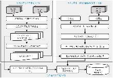
图1
基于子孔径分解和最小二乘配置区域网平差模型的林下地形反演框架"
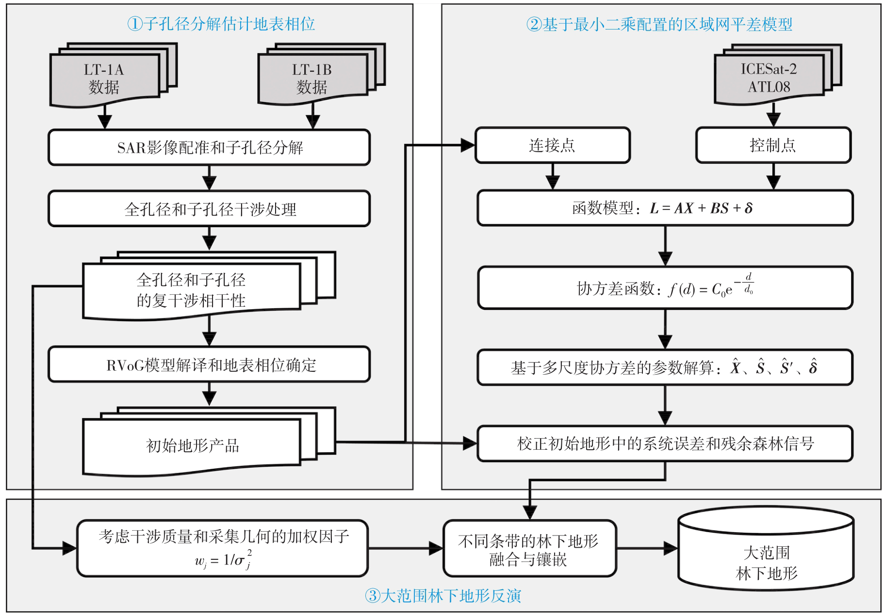

表1
LT-1 InSAR数据参数信息"
| 试验区 | 获取时间 | 入射角/(°) | 有效基线/m | 模糊高/m | 轨道 | 数量 |
|---|---|---|---|---|---|---|
| 广州 | 2022-10-10 | 32.18 | 1551.29 | 61.05 | 升轨 | 5 |
| 2022-11-03 | 37.32 | 1482.61 | 70.68 | 升轨 | 5 | |
| 2022-11-11 | 40.05 | 1423.67 | 80.13 | 升轨 | 5 | |
| 2022-11-18 | 20.79 | 1853.98 | 30.01 | 升轨 | 5 | |
| 根河 | 2022-09-19 | 29.82 | 1361.79 | 58.87 | 升轨 | 2 |
| 2022-10-05 | 39.93 | 609.26 | 162.39 | 升轨 | 3 | |
| 2022-10-11 | 36.18 | 2052.88 | 48.28 | 降轨 | 3 | |
| 2022-11-11 | 41.92 | 2040.65 | 58.22 | 降轨 | 5 | |
| 2022-11-20 | 22.39 | 1994.55 | 30.93 | 降轨 | 4 | |
| 2022-11-22 | 32.76 | 727.58 | 122.49 | 升轨 | 3 | |
| 2022-11-28 | 32.93 | 2091.18 | 42.67 | 降轨 | 5 |
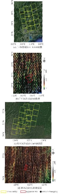
图2
试验区与试验数据覆盖"
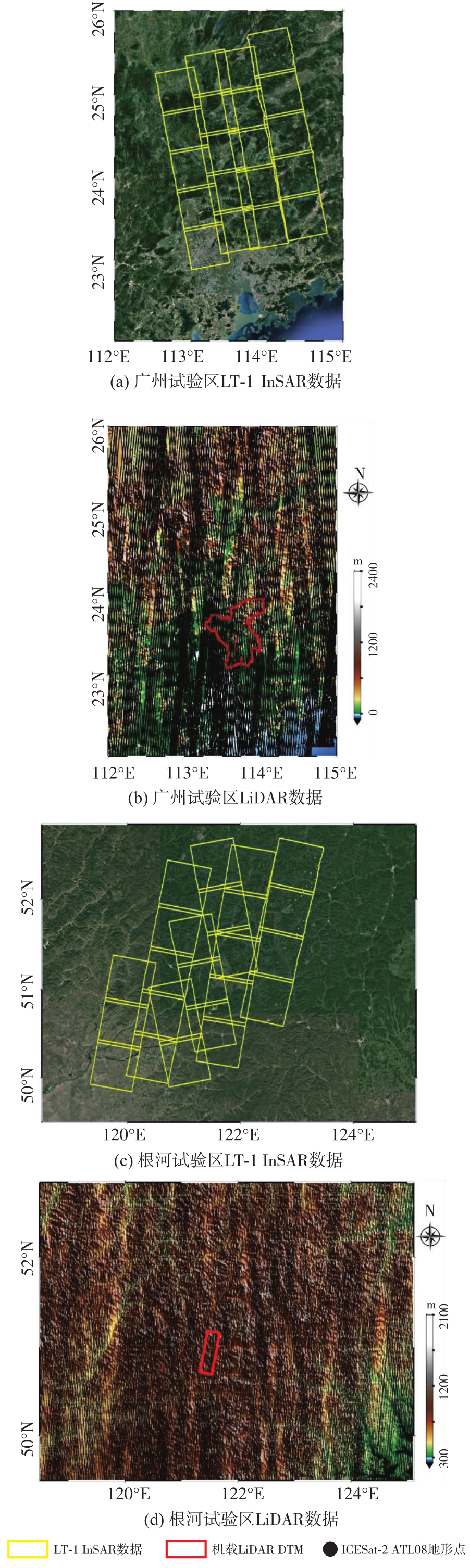
图3
广州试验区整体结果"
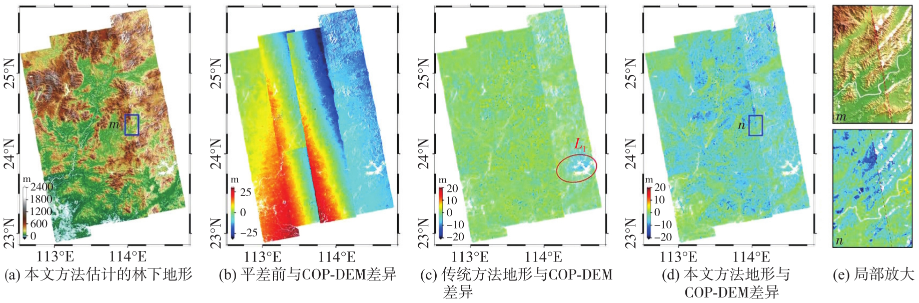
图4
根河试验区整体结果"
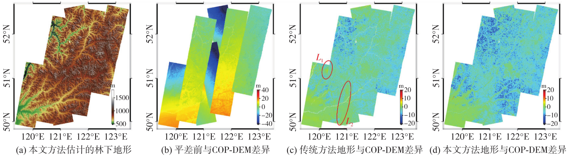
表2
利用ICESat-2评估两个试验区的地形精度"
| 地形产品 | 广州试验区 | 根河试验区 | ||||
|---|---|---|---|---|---|---|
| MAE | STD | RMSE | MAE | STD | RMSE | |
| LT-1 DEM | 3.41 | 4.47 | 5.62 | 4.06 | 2.63 | 4.83 |
| 林下地形 | 0.31 | 3.17 | 3.19 | 0.04 | 1.37 | 1.38 |
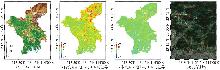
图5
广州试验区局部结果对比"
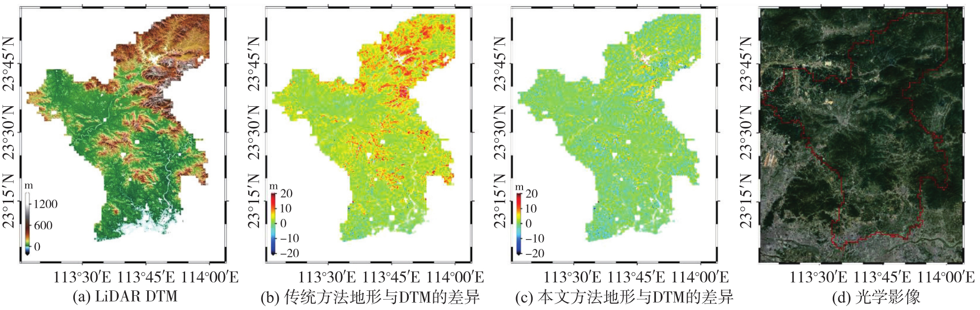
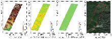
图6
根河试验区局部结果对比"
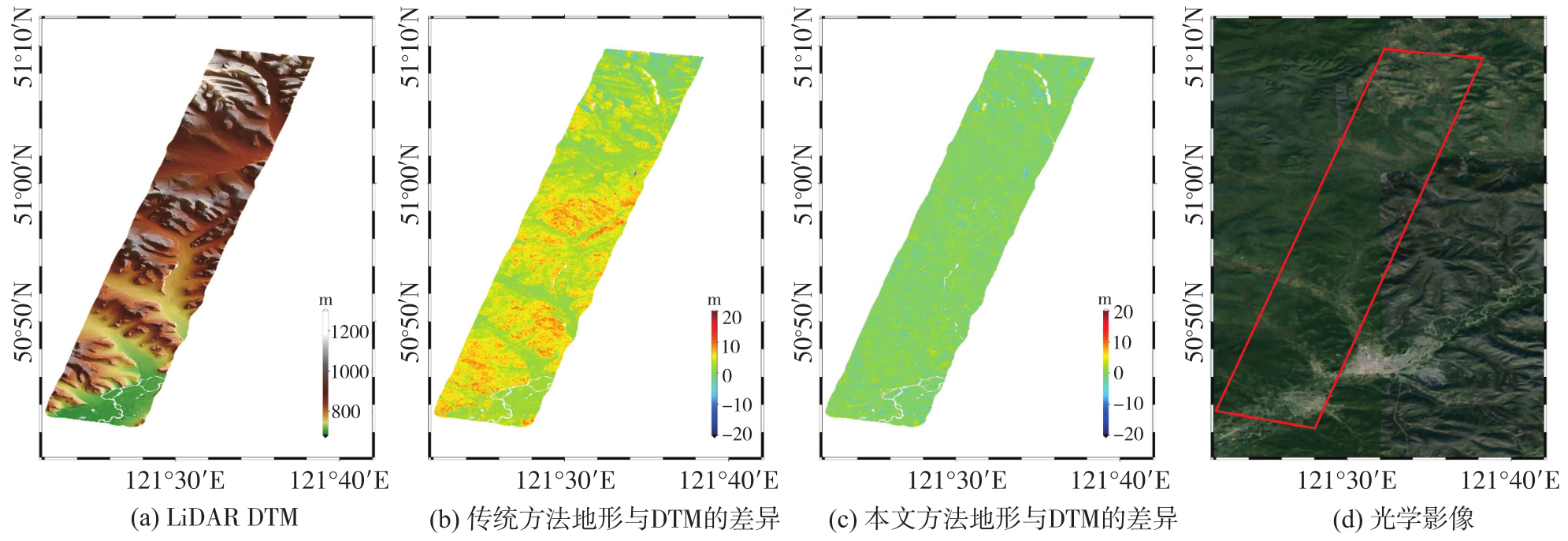
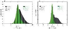
图7
以LiDAR DTM为参考的精度统计"
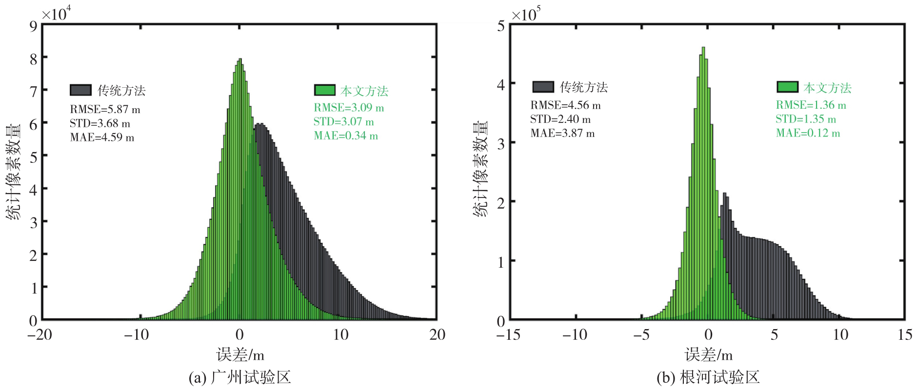
表3
不同方法估计的林下地形精度"
| 方法 | 广州试验区 | 根河试验区 | ||||
|---|---|---|---|---|---|---|
| MAE | STD | RMSE | MAE | STD | RMSE | |
| 传统方法 | 4.59 | 3.67 | 5.87 | 3.87 | 2.40 | 4.56 |
| 本文方法(单一尺度协方差) | 0.46 | 3.58 | 3.61 | 0.25 | 1.52 | 1.54 |
| 本文方法(多尺度协方差) | 0.34 | 3.07 | 3.09 | 0.12 | 1.35 | 1.36 |
表4
不同地形产品的精度评估"
| 地形产品 | 广州试验区 | 根河试验区 | ||||||||||
|---|---|---|---|---|---|---|---|---|---|---|---|---|
| ICESat-2全局验证 | LiDAR DTM局部验证 | ICESat-2全局验证 | LiDAR DTM局部验证 | |||||||||
| MAE | STD | RMSE | MAE | STD | RMSE | MAE | STD | RMSE | MAE | STD | RMSE | |
| SRTM DEM | 3.72 | 6.26 | 7.28 | 1.19 | 6.30 | 6.41 | 2.47 | 3.09 | 3.96 | 3.32 | 2.43 | 4.12 |
| COP DEM | 3.94 | 4.62 | 6.07 | 4.91 | 4.25 | 6.49 | 5.56 | 3.56 | 6.60 | 5.48 | 3.59 | 6.55 |
| LT-1 DEM(传统方法) | 3.35 | 4.28 | 5.44 | 4.52 | 3.58 | 5.76 | 4.01 | 2.58 | 4.76 | 3.82 | 2.37 | 4.50 |
| FAB DEM | 0.54 | 3.97 | 4.01 | 0.08 | 3.88 | 3.89 | 0.39 | 2.15 | 2.19 | 0.06 | 2.57 | 2.58 |
| 林下地形(本文方法) | 0.29 | 3.15 | 3.16 | 0.31 | 3.02 | 3.04 | 0.04 | 1.35 | 1.35 | 0.11 | 1.34 | 1.35 |
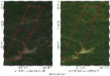
图8
根河试验区不同年份同一季节的多时相光学影像"
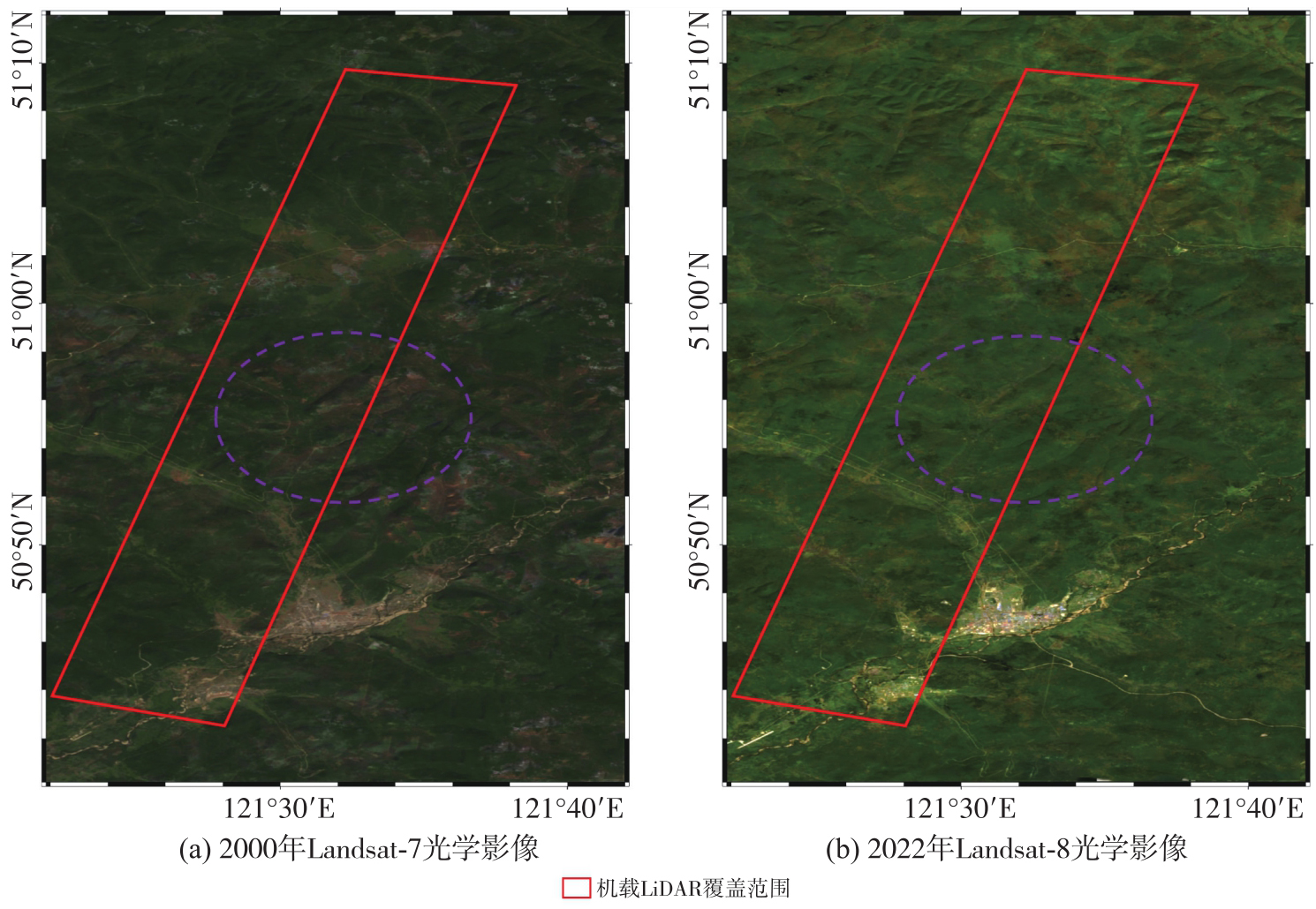
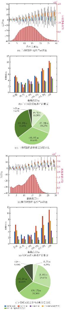
图9
不同森林高度区间内的地形误差分布和精度"
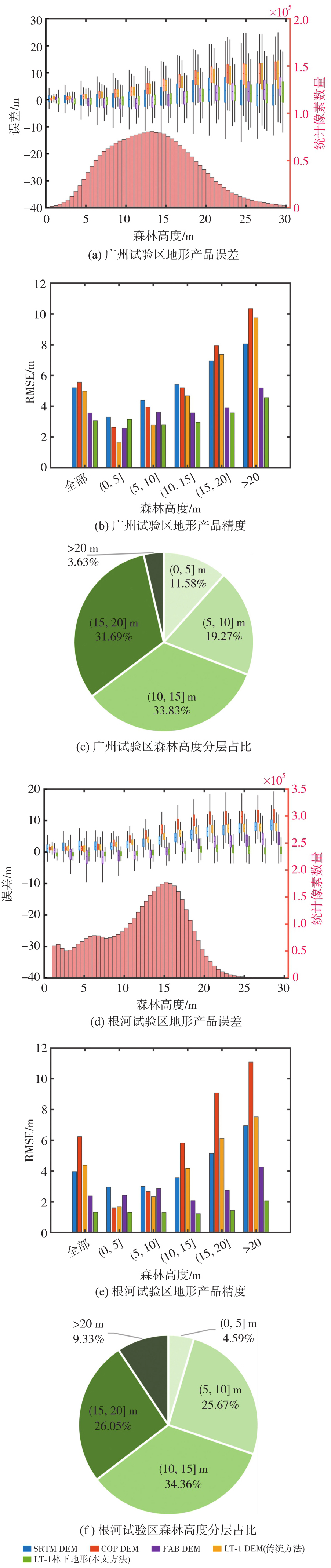
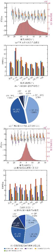
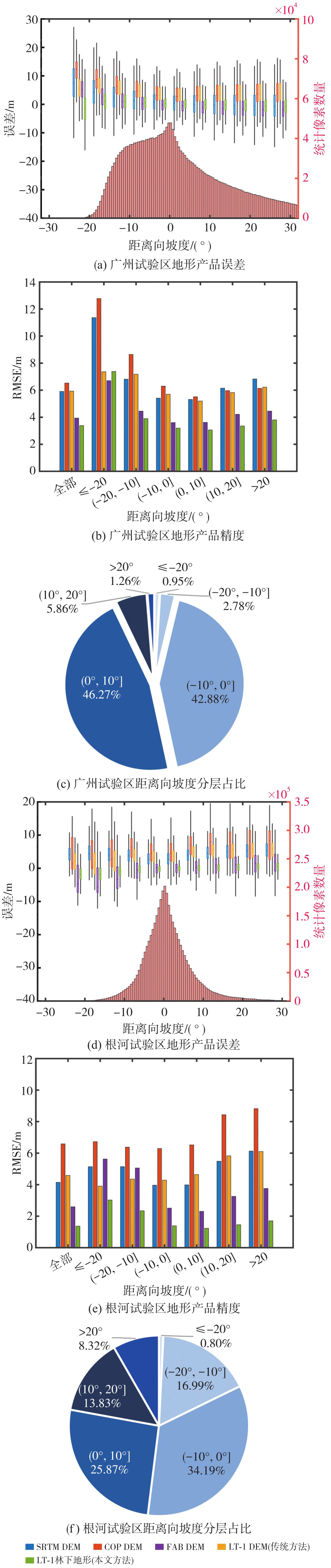
图10
不同坡度区间内的地形误差分布和精度"
| [1] | 朱建军, 付海强, 汪长城. InSAR林下地形测绘方法与研究进展[J]. 武汉大学学报(信息科学版), 2018, 43(12): 2030-2038. |
| ZHU Jianjun, FU Haiqiang, WANG Changcheng. Methods and research progress of underlying topography estimation over forest areas by InSAR[J]. Geomatics and Information Science of Wuhan University, 2018, 43(12): 2030-2038. | |
| [2] |
朱建军, 付海强, 汪长城. 极化干涉SAR地表覆盖层“穿透测绘”技术进展[J]. 测绘学报, 2022, 51(6): 983-995. DOI: .
doi: 10.11947/j.AGCS.2022.20220154 |
|
ZHU Jianjun, FU Haiqiang, WANG Changcheng. Research progress of “penetration mapping” of earth surface by PolInSAR[J]. Acta Geodaetica et Cartographica Sinica, 2022, 51(6): 983-995. DOI: .
doi: 10.11947/j.AGCS.2022.20220154 |
|
| [3] | RIZZOLI P, MARTONE M, GONZALEZ C, et al. Generation and performance assessment of the global TanDEM-X digital elevation model[J]. ISPRS Journal of Photogrammetry and Remote Sensing, 2017, 132: 119-139. |
| [4] | OKOLIE C J, MILLS J P, ADELEKE A K, et al. Assessment of the global Copernicus, NASADEM, ASTER and AW3D digital elevation models in Central and Southern Africa[J]. Geo-spatial Information Science, 2024, 27(4): 1362-1390. |
| [5] |
唐新明, 李涛, 张祥, 等. L波段差分干涉SAR卫星在轨应用关键参数测试分析[J]. 测绘学报, 2024, 53(10): 1863-1872. DOI: .
doi: 10.11947/j.AGCS.2024.20230240 |
|
TANG Xinming, LI Tao, ZHANG Xiang, et al. In-orbit application parameters test and analysis of L-band differential interferometric SAR satellite constellation[J]. Acta Geodaetica et Cartographica Sinica, 2024, 53(10): 1863-1872. DOI: .
doi: 10.11947/j.AGCS.2024.20230240 |
|
| [6] | TANG Xinming, LI Tao, CHEN Junli, et al. Twin-satellite constellation design and realization for terrain mapping and deformation monitoring: LuTan-1[J]. IEEE Transactions on Geoscience and Remote Sensing, 2025, 63: 5214014. |
| [7] | WANG R, LIU Kaiyu, LIU Dacheng, et al. LuTan-1: an innovative L-band spaceborne bistatic interferometric synthetic aperture radar mission[J]. IEEE Geoscience and Remote Sensing Magazine, 2025, 13(2): 58-78. |
| [8] | CLOUDE S R. Polarisation: applications in remote sensing[M/OL]. London: Oxford University Press, 2009[2026-02-11]. https://doi.org/10.1093/acprof:oso/9780199569731.001.0001. |
| [9] | PARDINI M, CAZCARRA-BES V, PAPATHANASSIOU K P. TomoSAR mapping of 3D forest structure: contributions of L-band configurations[J]. Remote Sensing, 2021, 13(12): 2255. |
| [10] | TREUHAFT R, LEI Yang, GONÇALVES F, et al. Tropical-forest structure and biomass dynamics from TanDEM-X radar interferometry[J]. Forests, 2017, 8(8): 277. |
| [11] | LEI Yang, LI Weiliang, YU Yanghai, et al. First demonstration of spaceborne L-band bistatic single-polarization single-baseline SAR interferometry on the retrieval of forest vertical structural information[J]. Remote Sensing of Environment, 2025, 329: 114916. |
| [12] | WANG Huiqiang, FU Haiqiang, ZHU Jianjun, et al. Estimation of subcanopy topography based on single-baseline TanDEM-X InSAR data[J]. Journal of Geodesy, 2021, 95(7): 84. |
| [13] | LIU Zhiwei, ZHU Jianjun, LOPEZ-SANCHEZ J M, et al. Simultaneous estimation of subcanopy topography and forest height with single-baseline single-polarization TanDEM-X interferometric data combined with ICESat-2 data[J]. IEEE Journal of Selected Topics in Applied Earth Observations and Remote Sensing, 2024, 17: 11598-11617. |
| [14] | HU Huacan, ZHU Jianjun, FU Haiqiang, et al. Automated estimation of sub-canopy topography combined with single-baseline single-polarization TanDEM-X InSAR and ICESat-2 data[J]. Remote Sensing, 2024, 16(7): 1155. |
| [15] | GARESTIER F, DUBOIS-FERNANDEZ P C, CHAMPION I. Forest height inversion using high-resolution P-band Pol-InSAR data[J]. IEEE Transactions on Geoscience and Remote Sensing, 2008, 46(11): 3544-3559. |
| [16] | FU Haiqiang, ZHU Jianjun, WANG Changcheng, et al. Underlying topography estimation over forest areas using single-baseline InSAR data[J]. IEEE Transactions on Geoscience and Remote Sensing, 2019, 57(5): 2876-2888. |
| [17] | ZHU Jianjun, XIE Yanzhou, FU Haiqiang, et al. Digital terrain, surface, and canopy height model generation with dual-baseline low-frequency InSAR over forest areas[J]. Journal of Geodesy, 2023, 97(11): 100. |
| [18] | 胡华参, 朱建军, 付海强, 等. LT-1双站InSAR林下地形测绘方法研究[J/OL]. 武汉大学学报(信息科学版), 1-19[2026-02-11]. https://doi.org/10.13203/j.whugis20250078. |
| HU Huacan, ZHU Jianjun, FU Haiqiang, et al. Research on sub-canopy topography mapping method based on LT-1 bistatic InSAR system[J/OL]. Geomatics and Information Science of Wuhan University, 1-19[2026-02-11]. https://doi.org/10.13203/j.whugis20250078. | |
| [19] | HU Huacan, FU Haiqiang, ZHU Jianjun, et al. Sub-canopy topography estimation based on sub-aperture decomposition and least-squares collocation from LuTan-1 InSAR data[J]. Journal of Geodesy, 2026, 100(1): 5. |
| [20] |
吴可夫, 付海强, 朱建军, 等. 顾及森林区穿透深度影响的LT-1 InSAR区域网平差[J]. 测绘学报, 2025, 54(6): 1009-1020. DOI: .
doi: 10.11947/j.AGCS.2025.20240426 |
|
WU Kefu, FU Haiqiang, ZHU Jianjun, et al. LT-1 InSAR block adjustment considering the impact of penetration depth in forest areas[J]. Acta Geodaetica et Cartographica Sinica, 2025, 54(6): 1009-1020. DOI: .
doi: 10.11947/j.AGCS.2025.20240426 |
|
| [21] | WESSEL B, GRUBER A, GONZALEZ J H, et al. TanDEM-X: DEM calibration concept[C]//Proceedings of 2008 IEEE International Geoscience and Remote Sensing Symposium. Boston: IEEE, 2008: 111-114. |
| [22] | GRUBER A, WESSEL B, HUBER M, et al. Operational TanDEM-X DEM calibration and first validation results[J]. ISPRS Journal of Photogrammetry and Remote Sensing, 2012, 73: 39-49. |
| [23] | TREUHAFT R N, MADSEN S N, MOGHADDAM M, et al. Vegetation characteristics and underlying topography from interferometric radar[J]. Radio Science, 1996, 31(6): 1449-1485. |
| [24] | JARMOŁOWSKI W, BAKUŁA M. Two covariance models in least squares collocation (LSC) tested in interpolation of local topography[J]. Contributions to Geophysics and Geodesy, 2013, 43(1): 1-19. |
| [25] | KOCH K R. Least squares adjustment and collocation[J]. Bulletin Géodésique, 1977, 51(2): 127-135. |
| [26] | LI Yi, FU Haiqiang, ZHU Jianjun, et al. A method for SRTM DEM elevation error correction in forested areas using ICESat-2 data and vegetation classification data[J]. Remote Sensing, 2022, 14(14): 3380. |
| [27] | KARRA K, KONTGIS C, STATMAN-WEIL Z, et al. Global land use/land cover with Sentinel 2 and deep learning[C]//Proceedings of 2021 IEEE International Geoscience and Remote Sensing Symposium IGARSS. Brussels: IEEE, 2021: 4704-4707. |
| [28] | WERNER M. Shuttle radar topography mission (SRTM) mission overview[J]. Frequenz, 2001, 55(3/4): 75-79. |
| [29] | MEADOWS M, JONES S, REINKE K. Vertical accuracy assessment of freely available global DEMs (FABDEM, Copernicus DEM, NASADEM, AW3D30 and SRTM) in flood-prone environments[J]. International Journal of Digital Earth, 2024, 17(1): 2308734. |
| [30] | YE Zilin, LONG Jiangping, ZHANG Tingchen, et al. L-band synthetic aperture radar and its application for forest parameter estimation, 1972 to 2024: a review[J]. Plants, 2024, 13(17): 2511. |
| [31] | TOUTIN T. Impact of terrain slope and aspect on radargrammetric DEM accuracy[J]. ISPRS Journal of Photogrammetry and Remote Sensing, 2002, 57(3): 228-240. |
| [32] | LI Yi, GAO Shijuan, ZHU Jianjun, et al. A gradient-constrained morphological operation for retrieving subcanopy topography over densely forested areas from ICESat-2/ATL03 data[J]. IEEE Transactions on Geoscience and Remote Sensing, 2024, 62: 4408213. |
| [33] | LI Guoyuan, YE Fanghong, TANG Xinming, et al. Influence of range gate width on detection probability and ranging accuracy of single photon laser altimetry satellite[J]. Journal of Geodesy and Geoinformation Science, 2020, 3(2): 36-44. |
| [34] | ABDEL-MAKSOUD H, AZIZ T A, ELSHARKAWY A S, et al. Advanced techniques for precision assessment in UAV LiDAR systems[J]. Journal of Geodesy and Geoinformation Science, 2025, 8(2): 90-107. |
| [1] | 吴可夫, 付海强, 朱建军, 韩启金, 王爱春, 张明霞, 李志伟. 顾及森林区穿透深度影响的LT-1 InSAR区域网平差[J]. 测绘学报, 2025, 54(6): 1009-1020. |
| [2] | 朱珺, 彭葳, 付海强, 欧蔓, 雷缮诚, 张石平. 观测信息不足条件下TanDEM-X InSAR的大范围林下地形反演[J]. 测绘学报, 2024, 53(5): 959-966. |
| [3] | 李欣, 蒋博洋, 汪韬阳, 张过, 崔浩, 程前. 面向高分三号全球正射影像生成的无控定位精度提升方法[J]. 测绘学报, 2023, 52(11): 1929-1940. |
| [4] | 张力, 刘玉轩, 孙洋杰, 蓝朝桢, 艾海滨, 樊仲藜. 数字航空摄影三维重建理论与技术发展综述[J]. 测绘学报, 2022, 51(7): 1437-1457. |
| [5] | 伍洋, 张永生, 李凯, 于英, 赖广陵. 附加视线向量修正的卫星影像区域网平差[J]. 测绘学报, 2021, 50(1): 85-96. |
| [6] | 韩杰, 陶醉, 谢勇, 刘其悦, 石宏斌. 顾及多积分时间特性的GF-4卫星PMS传感器交叉辐射定标[J]. 测绘学报, 2020, 49(10): 1311-1320. |
| [7] | 曹辉, 陶鹏杰, 李海鸿, 张祖勋. DEM约束的卫星影像定位法[J]. 测绘学报, 2020, 49(1): 79-91. |
| [8] | 王晋, 张勇, 张祖勋, 李晓, 陶鹏杰, 宋孟肖. ICESat激光高程点辅助的天绘一号卫星影像立体区域网平差[J]. 测绘学报, 2018, 47(3): 359-369. |
| [9] | 王涛, 张艳, 张永生, 莫德林, 周丽雅. 国产机载大视场三线阵CCD相机GNSS偏心矢量和IMU视轴偏心角标定技术[J]. 测绘学报, 2018, 47(11): 1474-1486. |
| [10] | 郑茂腾, 周顺平, 熊小东, 朱俊峰. GPU并行区域网平差[J]. 测绘学报, 2017, 46(9): 1193-1201. |
| [11] | 杨博, 王密, 皮英冬. 仅用虚拟控制点的超大区域无控制区域网平差[J]. 测绘学报, 2017, 46(7): 874-881. |
| [12] | 郑茂腾, 张永军, 朱俊峰, 熊小东, 周顺平. 一种快速有效的大数据区域网平差方法[J]. 测绘学报, 2017, 46(2): 188-197. |
| [13] | 韩杰, 谢勇. 星载多相机拼接成像传感器在轨辐射定标方法[J]. 测绘学报, 2017, 46(11): 1830-1840. |
| [14] | 熊新, 靳国旺, 张红敏, 徐青. 方差分量估计在机载InSAR区域网平差中的应用[J]. 测绘学报, 2016, 45(5): 592-600. |
| [15] | 闫利, 费亮, 叶志云, 夏旺. 大范围倾斜多视影像连接点自动提取的区域网平差法[J]. 测绘学报, 2016, 45(3): 310-317. |
| 阅读次数 | ||||||
|
全文 |
|
|||||
|
摘要 |
|
|||||
