


测绘学报 ›› 2026, Vol. 55 ›› Issue (8): 1382-1399.doi: 10.11947/j.AGCS.2026.20250517
• 摄影测量学与遥感 • 上一篇
汤圣君1,2( ), 李寒雨2, 王伟玺1,2, 谢林甫1,2, 李晓明1,2, 郭仁忠1,2()
收稿日期:2025-12-09
修回日期:2026-08-10
发布日期:2026-09-09
通讯作者:
郭仁忠
E-mail:shengjuntang@szu.edu.cn;guorz@szu.edu.cn
作者简介:汤圣君(1991—),男,博士,副教授,主要研究方向为城市三维要素结构化重建、多传感器融合测图等。E-mail:shengjuntang@szu.edu.cn
基金资助:
Shengjun Tang1,2(), Hanyu Li2, Weixi Wang1,2, Linfu Xie1,2, Xiaoming Li1,2, Renzhong Guo1,2()
Received:2025-12-09
Revised:2026-08-10
Published:2026-09-09
Contact:
Renzhong Guo
E-mail:shengjuntang@szu.edu.cn;guorz@szu.edu.cn
About author:Tang Shengjun (1991—), male, PhD, associate professor, majors in urban 3D element structured reconstruction and multi-sensor fusion mapping. E-mail: shengjuntang@szu.edu.cn
Supported by:摘要:
面向“实景三维中国”建设对海量倾斜摄影模型质量控制的迫切需求,针对现有全参考评估方法依赖昂贵真值数据、传统无参考方法缺乏逐面片精细化检测能力等瓶颈问题,本文提出一种基于内在一致性与图注意力网络的倾斜摄影三维Mesh模型无参考逐面片缺陷检测与质量评估方法。该方法突破了传统全参考评估对外部真值的依赖,以预测缺陷面片与面片级真值之间的一致性为主要评价对象,从倾斜摄影成像机理与几何拓扑约束出发,构建了包含光度一致性、多视几何结构、三角形可见性、局部点云密度、法向量一致性、三角形形状等多模态特征的先验指标体系;进而将三维网格建模为图结构,利用图注意力机制聚合邻域上下文信息,实现对局部网格质量的自适应推理。本文选取3组具有不同地物特征的典型区域数据进行质量评估精度分析,并基于大范围的倾斜摄影Mesh模型进行了泛化性与效率测试及分析。试验结果表明,本文方法能够有效识别几何噪点、几何变形拉伸、模型不全等典型缺陷,在不同类型的场景下可实现71%~78%的缺陷检测精度,80%以上的召回率。在百万级面片情况下,本文方法训练与推理时间在分钟级。同时试验结果显示该模型在未经测试的场景中依然可以实现高质量的质量检测,且论证了经过多级降采样后模型依然可以保持较高的检测精度并有效提升检测效率。该研究将为解决大规模三维网格数据的自动化质检与微观缺陷定位提供有效的技术途径,也将为我国实景三维模型的全量质量评估提供重要的解决方案。
中图分类号:
汤圣君, 李寒雨, 王伟玺, 谢林甫, 李晓明, 郭仁忠. 倾斜摄影三维Mesh模型无参考逐面片缺陷检测与质量评估方法[J]. 测绘学报, 2026, 55(8): 1382-1399.
Shengjun Tang, Hanyu Li, Weixi Wang, Linfu Xie, Xiaoming Li, Renzhong Guo. A no-reference method for face-level defect detection and quality assessment of oblique photogrammetric 3D mesh models[J]. Acta Geodaetica et Cartographica Sinica, 2026, 55(8): 1382-1399.
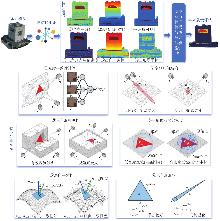
图1
本文方法总体技术路线"


表1
多模态特征表示"
| 特征名称 | 符号 | 数据源 | 物理含义 | 针对的主要缺陷类型 |
|---|---|---|---|---|
| 光度一致性 | xphoto | 影像+网格 | 多视纹理匹配的置信度 | 几何噪声、模糊、错位 |
| 多视几何结构 | xgeo | 影像+网格 | 空间前方交会的几何稳定性 | 深度误差大、几何噪点 |
| 三角形可见性 | xvis | 影像+网格 | 参与重建的观测冗余度 | 边缘悬浮物、虚假几何 |
| 局部点云密度 | xden | 网格 | 原始测量数据的支持程度 | 平面大孔洞填充、非真实表面 |
| 法向一致性 | xnorm | 网格 | 网格面与原始流形的拟合度 | 表面凹凸不平、拓扑翻转 |
| 三角形形状 | xshape | 网格 | 网格单元的几何健康度 | 狭长三角形、退化网格 |
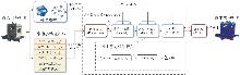
图2
Mesh-GAT模型与训练框架"
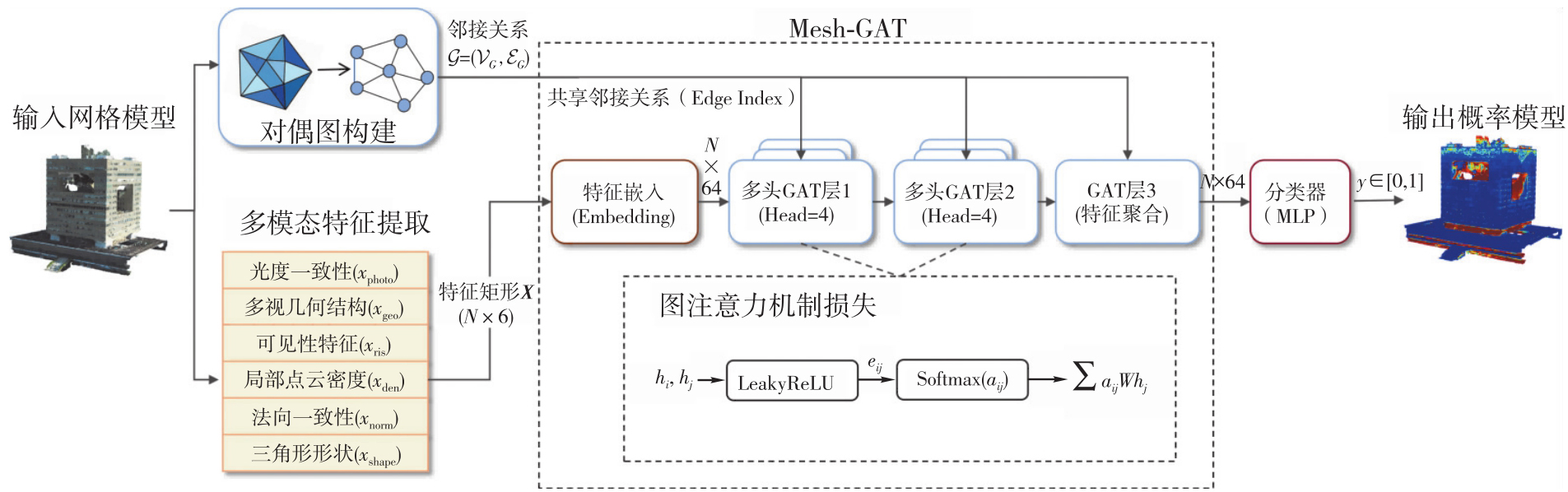
表2
试验数据集描述"
| 数据集名称 | 场景描述 | 待检测模型 | 真值模型 | 主要质量挑战 |
|---|---|---|---|---|
| 数据集1:ISPRS多特蒙德数据集 | 包含同步采集的机载倾斜与地面影像 | 机载影像重建 | 空地融合高质量Mesh模型 | 待检测模型在建筑立面、底部及遮挡区域存在明显的结构缺失和纹理变形 |
| 数据集2:复杂单体建筑数据集 | 具有显著特殊几何特征的单体建筑 | 机载影像重建 | 人工精细化建模得到的高精度模型 | 考验方法针对特定复杂几何结构的检测能力,模型易出现几何粘连或结构错误 |
| 数据集3:复杂建筑群数据集 | 大范围、高密度的城市建筑群体场景 | 机载影像重建 | 人工精细化建模完成的高精度模型 | 考察方法在大规模场景、严重相互遮挡条件下,对多样化建筑形态质量问题的稳健性 |
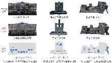
图3
试验区域与数据"
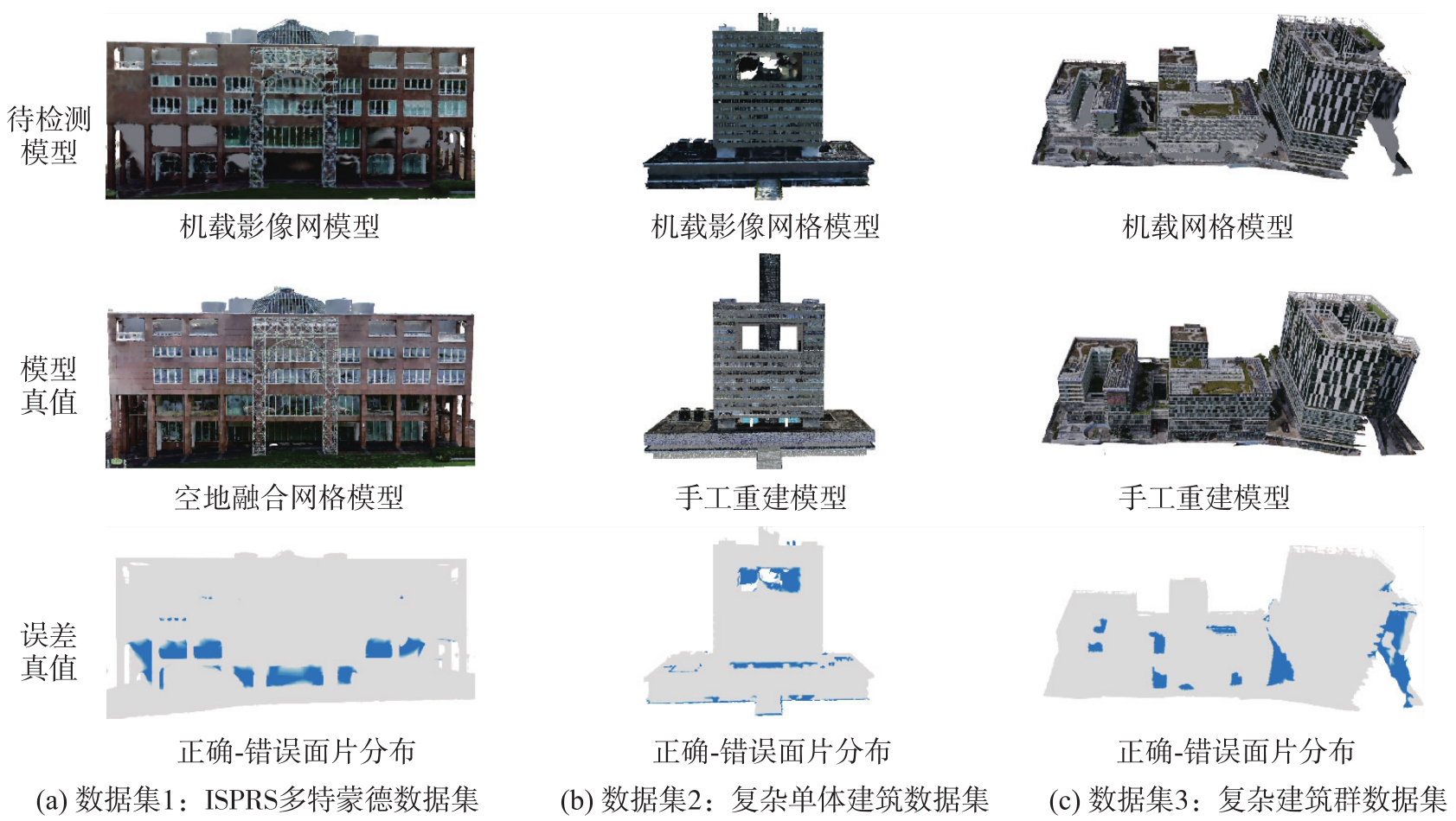
图4
训练样本选取策略与典型正负样本可视化"
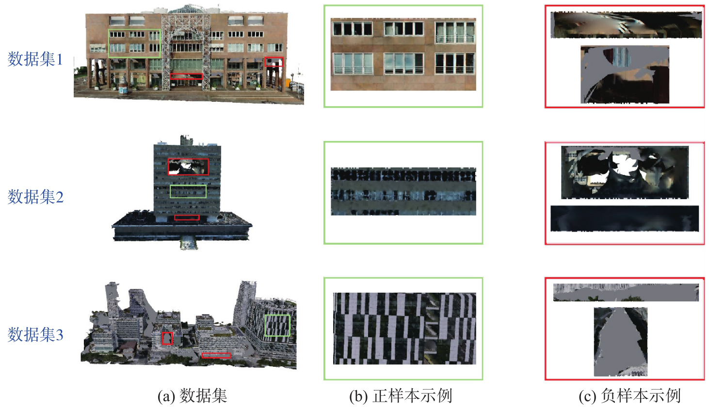
表3
试验数据集训练样本标注详细统计"
| 数据集名称 | 总网格数 | 正样本网格数 | 负样本网格数 | 训练集总数 | 训练集占比 |
|---|---|---|---|---|---|
| 数据集1 | 1 242 784 | 70 330 | 2 874 | 73 204 | 1/17 |
| 数据集2 | 944 524 | 145 600 | 5 775 | 151 375 | 1/6 |
| 数据集3 | 6 642 898 | 496 822 | 15 076 | 511 898 | 1/13 |
表4
质量评估精度与效率"
| 试验方法 | 数据集场景 | 数据规模 | 检测精度指标 | 效率指标 | |||||
|---|---|---|---|---|---|---|---|---|---|
| 测试网格数 | 辅助影像数 | Precision/(%) | Recall/(%) | F1值/(%) | IoU/(%) | 训练时间/s | 推理时间/s | ||
| Mesh-GAT | 数据集1 | 1 242 784 | 444 | 78.1 | 84.5 | 81.2 | 68.3 | 40 | 50 |
| 数据集2 | 944 524 | 337 | 71.5 | 81.2 | 76.0 | 61.3 | 23 | 40 | |
| 数据集3 | 6 642 898 | 235 | 76.7 | 89.4 | 82.6 | 70.3 | 130 | 319 | |
| 随机森林 | 数据集1 | 1 242 784 | 444 | 73.3 | 76.7 | 75.0 | 60.0 | 3 | 2 |
| 数据集2 | 944 524 | 337 | 63.4 | 72.1 | 67.5 | 50.9 | 2 | 2 | |
| 数据集3 | 6 642 898 | 235 | 64.2 | 78.5 | 70.6 | 54.6 | 12 | 6 | |
图5
检测精度与结果差异"
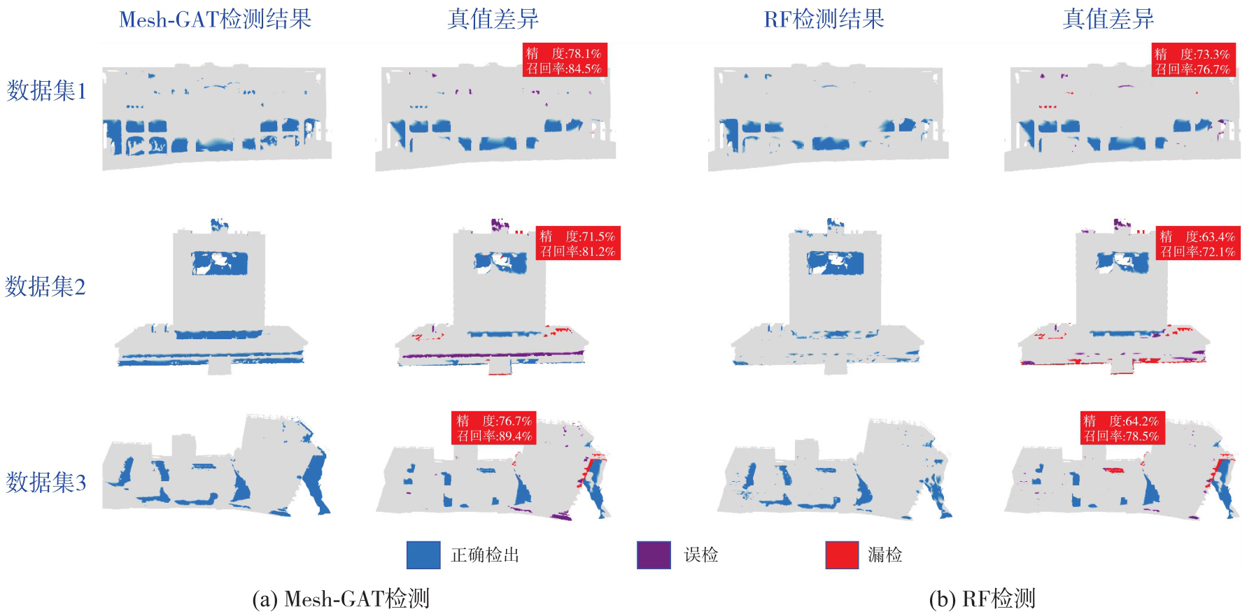
图6
检测结果可视化"
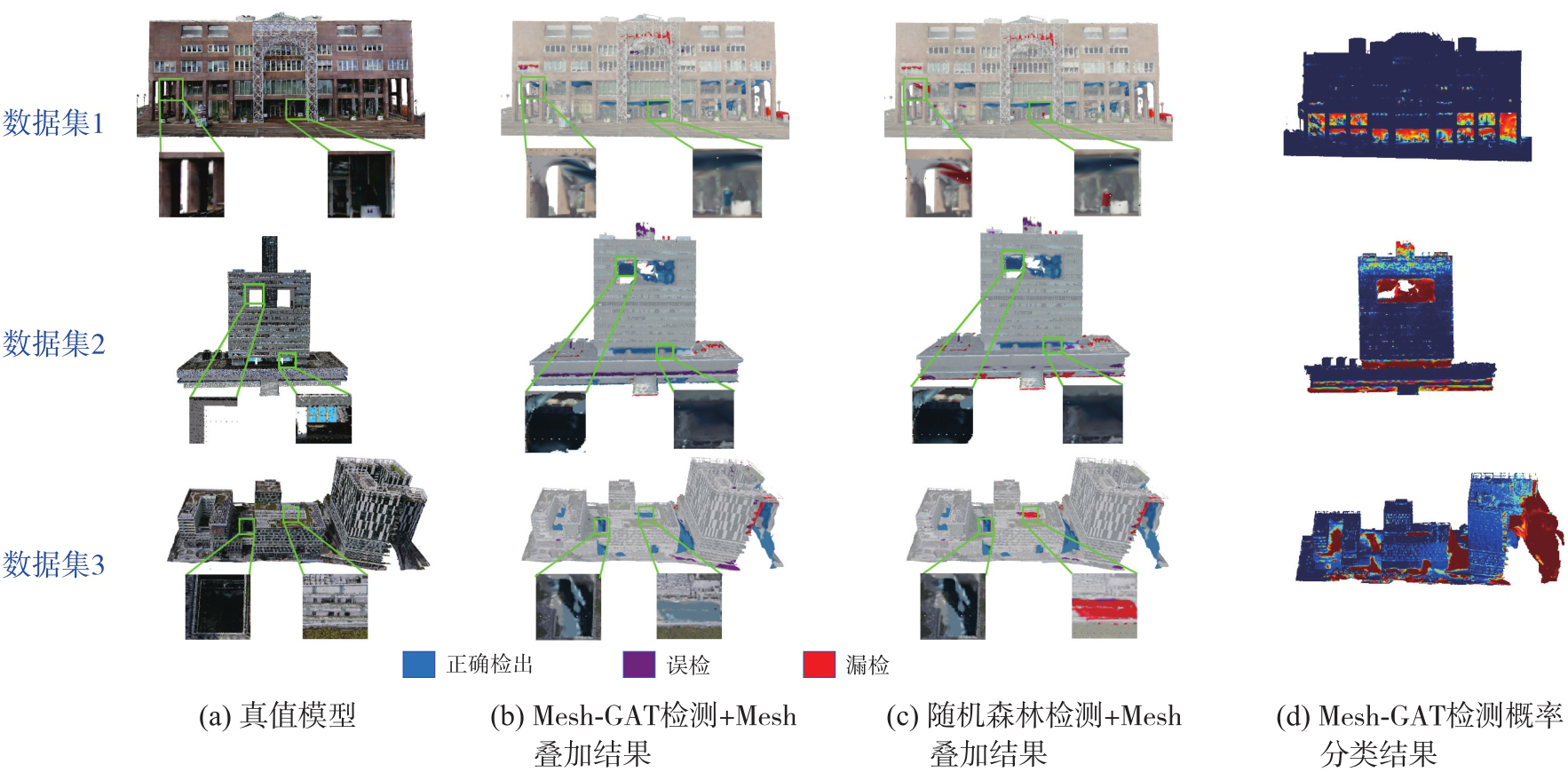
图7
伪漏(误)检情况"
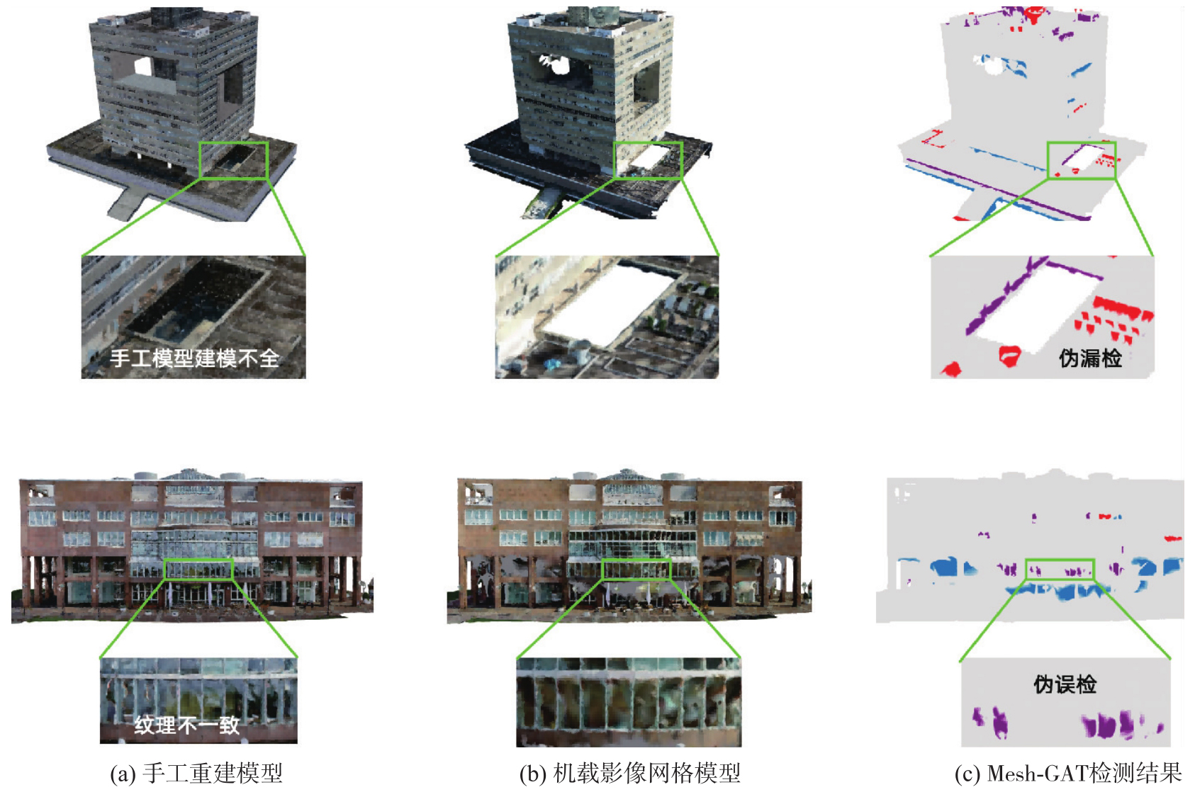
表5
数据集3上不同特征组合下的消融试验结果"
| 特征设置 | Precision | Recall | F1值 | IoU |
|---|---|---|---|---|
| 完整六维特征 | 76.7 | 89.4 | 82.6 | 70.3 |
| 去除三角形可见性 | 72.4 | 78.6 | 75.4 | 60.5 |
| 去除多视几何结构 | 63.8 | 91.2 | 75.1 | 60.1 |
| 去除光度一致性 | 68.5 | 73.1 | 70.7 | 54.7 |
| 去除三角顶点局部密度 | 74.2 | 68.4 | 71.2 | 55.3 |
| 去除三角形与点云法向一致性 | 64.9 | 59.8 | 62.2 | 45.2 |
| 去除三角形形状 | 70.6 | 70.2 | 70.4 | 54.3 |
| 仅使用视觉特征 | 80.3 | 61.5 | 69.7 | 53.4 |
| 仅使用几何特征 | 82.1 | 53.6 | 64.9 | 48.0 |
图8
不同特征组合下F1值与IoU消融性能对比"
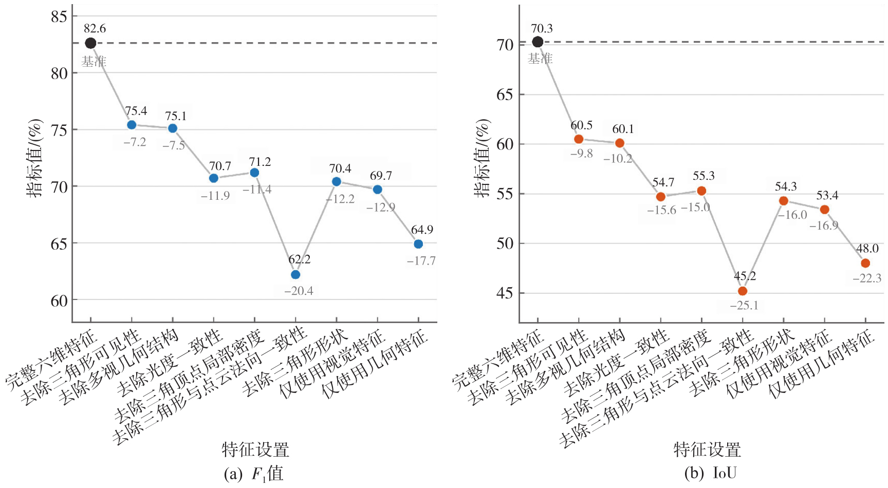
表6
数据集3上不同检测模型的缺陷检测结果对比"
| 模型 | Precision | Recall | F1分数 | IoU |
|---|---|---|---|---|
| Mesh-GAT | 76.7 | 89.4 | 82.6 | 70.3 |
| MLP | 54.8 | 86.2 | 67.0 | 50.4 |
| 随机森林 | 64.2 | 78.5 | 70.6 | 54.6 |
图9
场景泛化能力分析"

图10
街区级大场景三维Mesh模型缺陷检测结果可视化注:暖色区域代表高缺陷风险区域;冷色区域代表低缺陷风险区域。"
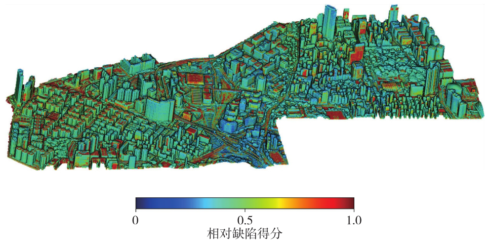
表7
降采样计算效率评估"
| 面片保留率/(%) | 数据规模 | 效率指标 | ||
|---|---|---|---|---|
| 测试网格数 | 辅助影像数 | 特征提取时间/min | 推理时间/s | |
| 100 | 17 560 000 | 428 | 148 | 867 |
| 70 | 12 210 000 | 428 | 102 | 698 |
| 40 | 6 960 000 | 428 | 58 | 302 |
| 10 | 1 760 000 | 428 | 18 | 152 |
| [1] |
杨必胜, 陈驰, 董震. 面向智能化测绘的城市地物三维提取[J]. 测绘学报, 2022, 51(7): 1476-1484. DOI: .
doi: 10.11947/j.AGCS.2022.20220183 |
|
Yang Bisheng, Chen Chi, Dong Zhen. 3D geospatial information extraction of urban objects for smart surveying and mapping[J]. Acta Geodaetica et Cartographica Sinica, 2022, 51(7): 1476-1484. DOI: .
doi: 10.11947/j.AGCS.2022.20220183 |
|
| [2] | 陈军, 刘建军, 田海波. 实景三维中国建设的基本定位与技术路径[J]. 武汉大学学报(信息科学版), 2022, 47(10): 1568-1575. |
| Chen Jun, Liu Jianjun, Tian Haibo. Basic directions and technological path for building 3D realistic geospatial scene in China[J]. Geomatics and Information Science of Wuhan University, 2022, 47(10): 1568-1575. | |
| [3] | 顾建祥, 董震, 郭王. 面向上海城市数字化转型的新型测绘[J]. 测绘通报, 2021(7): 131-134, 139. |
| Gu Jianxiang, Dong Zhen, Guo Wang. New surveying and mapping for the urban digital transformation of Shanghai[J]. Bulletin of Surveying and Mapping, 2021(7): 131-134, 139. | |
| [4] | 肖建华, 李海亭, 李鹏鹏, 等. 实景三维的内涵与分类分级[J]. 城市勘测, 2021(5): 5-10. |
| Xiao Jianhua, Li Haiting, Li Pengpeng, et al. Connotation, classification and grading of 3D real scene[J]. Urban Geotechnical Investigation & Surveying, 2021(5): 5-10. | |
| [5] | 朱庆, 朱军, 黄华平, 等. 实景三维空间信息平台与数字孪生川藏铁路[J]. 高速铁路技术, 2020, 11(2): 46-53. |
| Zhu Qing, Zhu Jun, Huang Huaping, et al. Real scene 3D spatial information platform and digital twin Sichuan-Tibet railway[J]. High Speed Railway Technology, 2020, 11(2): 46-53. | |
| [6] | 李清泉, 邵成立, 万剑华, 等. 优视摄影测量与泛在实景三维数据采集:以实景三维青岛为例[J]. 武汉大学学报(信息科学版), 2022, 47(10): 1587-1597. |
| Li Qingquan, Shao Chengli, Wan Jianhua, et al. Optimized views photogrammetry and ubiquitous real 3D data acquisition with the application case in Qingdao[J]. Geomatics and Information Science of Wuhan University, 2022, 47(10): 1587-1597. | |
| [7] |
肖雄武. 具备结构感知功能的倾斜摄影测量场景三维重建[J]. 测绘学报, 2019, 48(6): 802. DOI: .
doi: 10.11947/j.AGCS.2019.20180319 |
|
Xiao Xiongwu. Oblique photogrammetry based scene 3D reconstruction with structure sensing functions[J]. Acta Geodaetica et Cartographica Sinica, 2019, 48(6): 802. DOI: .
doi: 10.11947/j.AGCS.2019.20180319 |
|
| [8] | 李德仁, 肖雄武, 郭丙轩, 等. 倾斜影像自动空三及其在城市真三维模型重建中的应用[J]. 武汉大学学报(信息科学版), 2016, 41(6): 711-721. |
| Li Deren, Xiao Xiongwu, Guo Bingxuan, et al. Oblique image based automatic aerotriangulation and its application in 3D city model reconstruction[J]. Geomatics and Information Science of Wuhan University, 2016, 41(6): 711-721. | |
| [9] |
魏东, 刘欣怡, 张永军. 多视影像三维线云重建技术及其智能化发展展望[J]. 测绘学报, 2024, 53(6): 1025-1036. DOI: .
doi: 10.11947/j.AGCS.2024.20230447 |
|
Wei Dong, Liu Xinyi, Zhang Yongjun. The technology and intelligent development of 3D line cloud reconstruc-tion from multiple images[J]. Acta Geodaetica et Cartographica Sinica, 2024, 53(6): 1025-1036. DOI: .
doi: 10.11947/j.AGCS.2024.20230447 |
|
| [10] | 肖勇, 王成, 习晓环, 等. 机载激光雷达数据的建筑物三维模型重建[J]. 测绘科学, 2014, 39(11): 37-41. |
| Xiao Yong, Wang Cheng, Xi Xiaohuan, et al. 3D building model reconstruction from airborne LiDAR data[J]. Science of Surveying and Mapping, 2014, 39(11): 37-41. | |
| [11] | 刘欣怡, 张永军, 范伟伟, 等. 无人机倾斜摄影三维建模技术研究现状及展望[J]. 时空信息学报, 2023, 30(1): 41-48. |
| Liu Xinyi, Zhang Yongjun, Fan Weiwei, et al. 3D modeling based on UAV oblique photogrammetry: research status and prospect[J]. Journal of Spatio-Temporal Information, 2023, 30(1): 41-48. | |
| [12] |
朱庆, 张利国, 丁雨淋, 等. 从实景三维建模到数字孪生建模[J]. 测绘学报, 2022, 51(6): 1040-1049. DOI: .
doi: 10.11947/j.AGCS.2022.20210640 |
|
Zhu Qing, Zhang Liguo, Ding Yulin, et al. From real 3D modeling to digital twin modeling[J]. Acta Geodaetica et Cartographica Sinica, 2022, 51(6): 1040-1049. DOI: .
doi: 10.11947/j.AGCS.2022.20210640 |
|
| [13] |
单杰, 李志鑫, 张文元. 大规模三维城市建模进展[J]. 测绘学报, 2019, 48(12): 1523-1541. DOI: .
doi: 10.11947/j.AGCS.2019.20190471 |
|
Shan Jie, Li Zhixin, Zhang Wenyuan. Recent progress in large-scale 3D city modeling[J]. Acta Geodaetica et Cartographica Sinica, 2019, 48(12): 1523-1541. DOI: .
doi: 10.11947/j.AGCS.2019.20190471 |
|
| [14] | 王丙涛, 王继. 基于倾斜摄影技术的三维建模生产与质量分析[J]. 城市勘测, 2015(5): 80-82, 85. |
| Wang Bingtao, Wang Ji. Production and quality analysis of 3D city modeling using oblique photogrametric technology[J]. Urban Geotechnical Investigation & Surveying, 2015(5): 80-82, 85. | |
| [15] | Verdie Y, Lafarge F, Alliez P. LOD generation for urban scenes[J]. ACM Transactions on Graphics, 2015, 34(3): 1-14. |
| [16] |
李清泉, 黄惠, 姜三, 等. 优视摄影测量方法及精度分析[J]. 测绘学报, 2022, 51(6): 996-1007. DOI: .
doi: 10.11947/j.AGCS.2022.20210685 |
|
Li Qingquan, Huang Hui, Jiang San, et al. Optimized views photogrammetry and its precision analysis[J]. Acta Geodaetica et Cartographica Sinica, 2022, 51(6): 996-1007. DOI: .
doi: 10.11947/j.AGCS.2022.20210685 |
|
| [17] | 赵建春. 基于倾斜摄影测量技术的实景三维建模及精度分析[J]. 科学技术创新, 2022(7): 127-130. |
| Zhao Jianchun. 3D modeling and precision analysis of real scene based on oblique photogrammetry technology[J]. Scientific and Technological Innovation, 2022(7): 127-130. | |
| [18] | Sorgente T, Biasotti S, Manzini G, et al. A survey of indicators for mesh quality assessment[J]. Computer Graphics Forum, 2023, 42(2): 461-483. |
| [19] | 杨斌, 李晓强, 李伟, 等. 基于表面粗糙度的三维模型质量评价研究[J]. 计算机科学, 2011, 38(1): 276-278, 285. |
| Yang Bin, Li Xiaoqiang, Li Wei, et al. Quality assessment for 3D model based on surface roughness[J]. Computer Science, 2011, 38(1): 276-278, 285. | |
| [20] | 张号, 王炜, 邓强, 等. 倾斜摄影实景三维模型质量评价[J]. 北京测绘, 2020, 34(1): 56-60. |
| Zhang Hao, Wang Wei, Deng Qiang, et al. The quality evaluation of 3D model of tilt photography reality[J]. Beijing Surveying and Mapping, 2020, 34(1): 56-60. | |
| [21] | 张雯, 程亮, 张群, 等. 三维模型几何质量评价方法[J]. 测绘通报, 2014(7): 44-47. |
| Zhang Wen, Cheng Liang, Zhang Qun, et al. An evaluation method for the geometry quality of three-dimensional models[J]. Bulletin of Surveying and Mapping, 2014(7): 44-47. | |
| [22] | 钟炜, 郭丽. 城市级实景三维单体化模型质检方法研究[J]. 地理空间信息, 2025, 23(7): 133-136. |
| Zhong Wei, Guo Li. Research on quality inspection method for urban 3D real scene monolithic model[J]. Geospatial Information, 2025, 23(7): 133-136. | |
| [23] | Maraş E E, Nasery N. Investigating the length, area and volume measurement accuracy of UAV-Based oblique photogrammetry models produced with and without ground control points[J]. International Journal of Engineering and Geosciences, 2023, 8(1): 32-51. |
| [24] | Xu Y M, Zhang J X, Zhao H T, et al. Research on quality framework of real scene 3D model based on oblique photogrammetry[J]. The International Archives of the Photogrammetry, Remote Sensing and Spatial Information Sciences, 2021, XLIII-B3-2021: 791-796. |
| [25] | Abouelaziz I, El Hassouni M, Cherifi H. No-reference 3D mesh quality assessment based on dihedral angles model and support vector regression[C]//Proceedings of 2016 Image and Signal Processing. Cham: Springer International Publishing, 2016: 369-377. |
| [26] | Nouri A, Charrier C, Lézoray O. 3D blind mesh quality assessment index[C]//Proceedings of 2017 IS&T International Symposium on Electronic Imaging. Burlingame: Society for Imaging Science and Technology, 2017: 9-26. |
| [27] | Nehmé Y, Delanoy J, Dupont F, et al. Textured mesh quality assessment: large-scale dataset and deep learning-based quality metric[J]. ACM Transactions on Graphics, 2023, 42(3): 1-20. |
| [28] | Zhang Zicheng, Sun Wei, Min Xiongkuo, et al. No-reference quality assessment for 3D colored point cloud and mesh models[J]. IEEE Transactions on Circuits and Systems for Video Technology, 2022, 32(11): 7618-7631. |
| [29] | Dong Lu, Fang Yuming, Lin Weisi, et al. Perceptual quality assessment for 3D triangle mesh based on curvature[J]. IEEE Transactions on Multimedia, 2015, 17(12): 2174-2184. |
| [30] | Ibork Z, Nouri A, Lézoray O, et al. No reference 3D mesh quality assessment using deep convolutional features[C]//Proceedings of 2023 International Symposium on Image and Signal Processing and Analysis. Rome: IEEE, 2023: 1-6. |
| [31] | Liu Qi, Yuan Hui, Su Honglei, et al. PQA-net: deep no reference point cloud quality assessment via multi-view projection[J]. IEEE Transactions on Circuits and Systems for Video Technology, 2021, 31(12): 4645-4660. |
| [32] | Dong S, Yan Q, Xu Y, et al. Quality inspection and analysis of three-dimensional geographic information model based on oblique photogrammetry[C]//Proceedings of 2018 International Archives of the Photogrammetry, Remote Sensing and Spatial Information Sciences. Beijing: Copernicus Publications, 2018: 299-302. |
| [1] | 叶晨鸣, 康志忠, 才谨豪, 左秉正, 邵帅, 李彦. 形态特征引导的月表地理实体实景三维建模方法[J]. 测绘学报, 2026, 55(3): 525-535. |
| [2] | 季顺平, 刘瑾, 高建, 龚健雅. 多视影像深度学习密集匹配三维重建智能框架[J]. 测绘学报, 2025, 54(9): 1633-1646. |
| [3] | 林浩嘉, 郭仁忠, 贺彪, 蒯希, 马丁, 李程鹏. 视觉感知导向的实景三维建筑场景LOD自适应可视化[J]. 测绘学报, 2025, 54(6): 1054-1070. |
| [4] | 王庆栋, 王腾飞, 张力. 面向实景三维的点云跨模态对比掩码自编码预训练方法[J]. 测绘学报, 2025, 54(4): 675-687. |
| [5] | 刘纪平, 周婷婷, 刘坡, 徐胜华, 王勇, 翟亮, 王琢璐, 祁俊杰, 马梦赫. 实景三维地理实体建模的思考与实践[J]. 测绘学报, 2025, 54(4): 650-660. |
| [6] | 陈军, 田海波, 高崟, 张元杰, 刘万增, 武昊, 张宏伟, 黄蔚, 刘建军. 实景三维中国的总体架构与主体技术[J]. 测绘学报, 2025, 54(4): 636-649. |
| [7] | 赵学胜, 谢文澜, 孙文彬. 空间格网互操作的研究进展与关键问题[J]. 测绘学报, 2025, 54(10): 1727-1740. |
| [8] | 马威, 涂强, 潘建平, 赵立都, 涂伟, 李清泉. 桥梁实景三维高斯辐射场建模[J]. 测绘学报, 2024, 53(9): 1694-1705. |
| [9] | 魏东, 刘欣怡, 张永军. 多视影像三维线云重建技术及其智能化发展展望[J]. 测绘学报, 2024, 53(6): 1025-1036. |
| [10] | 肖腾, 王鑫, 梅熙, 叶志伟, 颜青松, 邓非. 摄影测量局部场景稳健合并的并行式运动恢复结构方法[J]. 测绘学报, 2024, 53(2): 332-343. |
| [11] | 张荣庭, 张广运, 尹继豪. 复杂城市动态图卷积网络三维场景语义分割法[J]. 测绘学报, 2023, 52(10): 1703-1713. |
| [12] | 朱庆, 张利国, 丁雨淋, 胡翰, 葛旭明, 刘铭崴, 王玮. 从实景三维建模到数字孪生建模[J]. 测绘学报, 2022, 51(6): 1040-1049. |
| [13] | 李清泉, 黄惠, 姜三, 胡庆武, 于文率. 优视摄影测量方法及精度分析[J]. 测绘学报, 2022, 51(6): 996-1007. |
| [14] | 李德仁. 展望5G/6G时代的地球空间信息技术[J]. 测绘学报, 2019, 48(12): 1475-1481. |
| 阅读次数 | ||||||
|
全文 |
|
|||||
|
摘要 |
|
|||||
