


测绘学报 ›› 2025, Vol. 54 ›› Issue (8): 1476-1488.doi: 10.11947/j.AGCS.2025.20240457
方帅1,2( ), 刘加恩1, 张晶1
收稿日期:2024-11-11
修回日期:2025-06-19
出版日期:2025-09-16
发布日期:2025-09-16
作者简介:方帅(1978—),女,博士,教授,研究方向为图像复原和视觉检测。E-mail:fangshuai@hfut.edu.cn
基金资助:
Shuai FANG1,2(), Jiaen LIU1, Jing ZHANG1
Received:2024-11-11
Revised:2025-06-19
Online:2025-09-16
Published:2025-09-16
About author:FANG Shuai (1978—), female, PhD, professor, majors in image restoration and visual inspection. E-mail: fangshuai@hfut.edu.cn
Supported by:摘要:
时空融合算法旨在生成具有高空间分辨率的稠密时间序列图像,对监测地表精细动态变化具有重要意义。然而,现有时空融合算法在土地覆盖变化区域易受参考图像的误导,同时由小目标构成的异质区域的重建较为困难。为此,本文提出了一种自适应参考特征引入与多尺度特征聚合的时空融合算法。在编码阶段,设计了自适应参考特征引入模块,根据时序粗图像对提供的变化信息及门控结构,实现对参考细图像的自适应引入,既利用参考信息提高预测精度,又抑制参考信息对变化区域的误导;在解码器阶段,设计了多尺度特征聚合策略,为解码器每一层聚合不同尺度的信息,并结合通道注意力机制筛选重要特征信息,提高了异质区域的重建精度;最后,在损失函数中引入焦频损失项,从频域分布的角度,增强生成图像的真实性和关注困难频段的重建,弥补了空谱损失的不足。在LGC、CIA和Wuhan数据集上的试验结果表明,与其他6种算法相比,本文算法具有更好的融合结果。
中图分类号:
方帅, 刘加恩, 张晶. 自适应参考特征引入与多尺度特征聚合的时空融合算法[J]. 测绘学报, 2025, 54(8): 1476-1488.
Shuai FANG, Jiaen LIU, Jing ZHANG. Spatio-temporal fusion algorithm based on adaptive reference feature incorporation and multi-scale feature aggregation[J]. Acta Geodaetica et Cartographica Sinica, 2025, 54(8): 1476-1488.

图1
本文算法整体框架"

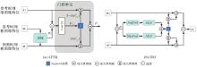
图2
自适应参考特征引入模块结构"

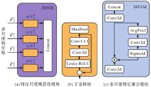
图3
特征尺度规范化模块和多尺度特征聚合模块结构注:Concat为拼接。"

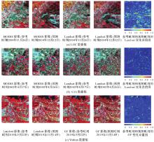
图4
数据集展示"

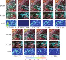
图5
各算法在LGC数据集上的试验结果"

表1
各算法在LGC数据集的试验结果"
| 算法 | RMSE↓ | SSIM↑ | SAM↓ | CC↑ |
|---|---|---|---|---|
| STARFM | 0.040 9 | 0.757 0 | 0.210 0 | 0.820 7 |
| FSDAF | 0.040 2 | 0.759 5 | 0.211 8 | 0.829 4 |
| STFDCNN | 0.033 5 | 0.806 9 | 0.160 8 | 0.873 9 |
| EDCSTFN | 0.032 7 | 0.811 3 | 0.159 9 | 0.880 8 |
| GAN-STFM | 0.033 4 | 0.811 7 | 0.164 5 | 0.878 7 |
| MLFF-GAN | 0.028 0 | 0.830 6 | 0.135 1 | 0.913 5 |
| 本文算法 | 0.026 5 | 0.847 9 | 0.123 6 | 0.923 2 |
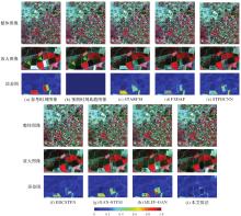
图6
各算法在CIA数据集上的试验结果"

表2
各算法在CIA数据集的试验结果"
| 算法 | RMSE↓ | SSIM↑ | SAM↓ | CC↑ |
|---|---|---|---|---|
| STARFM | 0.027 8 | 0.843 3 | 0.074 1 | 0.961 4 |
| FSDAF | 0.027 2 | 0.840 4 | 0.072 1 | 0.962 9 |
| STFDCNN | 0.026 5 | 0.854 5 | 0.067 2 | 0.963 6 |
| EDCSTFN | 0.023 9 | 0.871 0 | 0.060 0 | 0.970 4 |
| GAN-STFM | 0.026 4 | 0.858 2 | 0.072 4 | 0.964 0 |
| MLFF-GAN | 0.023 8 | 0.863 3 | 0.062 6 | 0.970 8 |
| 本文算法 | 0.023 1 | 0.874 8 | 0.059 1 | 0.972 6 |
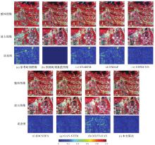
图7
各算法在Wuhan数据集上的试验结果"

表3
各算法在Wuhan数据集的试验结果"
| 算法 | RMSE↓ | SSIM↑ | SAM↓ | CC↑ |
|---|---|---|---|---|
| STARFM | 0.044 7 | 0.744 9 | 0.129 7 | 0.873 6 |
| FSDAF | 0.046 0 | 0.733 4 | 0.146 7 | 0.835 3 |
| STFDCNN | 0.018 6 | 0.893 5 | 0.064 1 | 0.955 9 |
| EDCSTFN | 0.018 5 | 0.901 9 | 0.074 6 | 0.962 0 |
| GAN-STFM | 0.019 5 | 0.888 6 | 0.084 3 | 0.954 2 |
| MLFF-GAN | 0.028 6 | 0.809 8 | 0.091 9 | 0.893 5 |
| 本文算法 | 0.014 7 | 0.918 6 | 0.048 1 | 0.971 6 |
表4
消融试验的定量评价"
| 数据集 | 评价指标 | 去除AFIM | 去除MFAM | 去除FFL | 完整算法结构 |
|---|---|---|---|---|---|
| LGC | RMSE↓ | 0.027 7 | 0.026 7 | 0.026 5 | 0.026 5 |
| SSIM↑ | 0.839 0 | 0.844 3 | 0.846 5 | 0.847 9 | |
| SAM↓ | 0.130 4 | 0.127 9 | 0.124 6 | 0.123 6 | |
| CC↑ | 0.916 8 | 0.921 2 | 0.923 0 | 0.923 2 | |
| CIA | RMSE↓ | 0.023 3 | 0.023 8 | 0.023 4 | 0.023 1 |
| SSIM↑ | 0.870 8 | 0.868 1 | 0.871 8 | 0.874 8 | |
| SAM↓ | 0.061 7 | 0.062 2 | 0.059 9 | 0.059 1 | |
| CC↑ | 0.972 3 | 0.970 7 | 0.972 1 | 0.972 6 | |
| Wuhan | RMSE↓ | 0.015 7 | 0.016 3 | 0.015 5 | 0.014 7 |
| SSIM↑ | 0.888 9 | 0.905 0 | 0.913 9 | 0.918 6 | |
| SAM↓ | 0.057 8 | 0.055 6 | 0.052 8 | 0.048 1 | |
| CC↑ | 0.968 8 | 0.965 9 | 0.969 3 | 0.971 6 |
表5
焦频损失和对抗损失的对比试验结果"
| 数据集 | 评价指标 | GANSTFM | FFLSTFM | MLFFGAN | MLFFFFL |
|---|---|---|---|---|---|
| LGC | RMSE↓ | 0.033 4 | 0.033 2 | 0.028 0 | 0.027 0 |
| SSIM↑ | 0.811 7 | 0.812 9 | 0.830 6 | 0.838 5 | |
| SAM↓ | 0.164 5 | 0.159 4 | 0.135 1 | 0.130 8 | |
| CC↑ | 0.878 7 | 0.880 1 | 0.913 5 | 0.919 0 | |
| CIA | RMSE↓ | 0.026 4 | 0.025 2 | 0.023 8 | 0.023 8 |
| SSIM↑ | 0.858 2 | 0.861 6 | 0.863 3 | 0.867 6 | |
| SAM↓ | 0.072 4 | 0.063 6 | 0.062 6 | 0.061 9 | |
| CC↑ | 0.964 0 | 0.967 2 | 0.970 8 | 0.971 0 | |
| Wuhan | RMSE↓ | 0.019 5 | 0.016 2 | 0.028 6 | 0.026 7 |
| SSIM↑ | 0.888 6 | 0.893 1 | 0.809 8 | 0.817 3 | |
| SAM↓ | 0.084 3 | 0.060 9 | 0.091 9 | 0.084 2 | |
| CC↑ | 0.954 2 | 0.961 7 | 0.893 5 | 0.906 8 |

图8
焦频损失和对抗损失对比试验"

表6
时空融合方法的参数和乘法累加运算次数"
| 方法 | 参数量 | MACs |
|---|---|---|
| STFDCNN | 0.087×10⁶ | 5.459×10⁹ |
| EDCSTFN | 0.284×10⁶ | 18.585×10⁹ |
| 本文算法 | 3.243×10⁶ | 12.192×10⁹ |
| GAN-STFM | 0.583×10⁶(生成器参数) | 37.760×10⁹ |
| 3.666×10⁶(鉴别器参数) | ||
| MLFF-GAN | 5.925×10⁶(生成器参数) | 17.369×10⁹ |
| 2.776×10⁶(鉴别器参数) |
| [1] |
张良培, 何江, 杨倩倩, 等. 数据驱动的多源遥感信息融合研究进展[J]. 测绘学报, 2022, 51(7): 1317-1337. DOI: .
doi: 10.11947/j.AGCS.2022.20220171 |
|
ZHANG Liangpei, HE Jiang, YANG Qianqian, et al. Data-driven multi-source remote sensing data fusion: progress and challenges[J]. Acta Geodaetica et Cartographica Sinica, 2022, 51(7): 1317-1337. DOI: .
doi: 10.11947/j.AGCS.2022.20220171 |
|
| [2] | LI Jun, LI Yunfei, HE Lin, et al. Spatio-temporal fusion for remote sensing data: an overview and new benchmark[J]. Science China Information Sciences, 2020, 63(4): 140301. |
| [3] | ZHU Xiaolin, CAI Fangyi, TIAN Jiaqi, et al. Spatiotemporal fusion of multisource remote sensing data: literature survey, taxonomy, principles, applications, and future directions[J]. Remote Sensing, 2018, 10(4): 527. |
| [4] |
黄波, 赵涌泉. 多源卫星遥感影像时空融合研究的现状及展望[J]. 测绘学报, 2017, 46(10): 1492-1499. DOI: .
doi: 10.11947/j.AGCS.2017.20170376 |
|
HUANG Bo, ZHAO Yongquan. Research status and prospect of spatiotemporal fusion of multi-source satellite remote sensing imagery[J]. Acta Geodaetica et Cartographica Sinica, 2017, 46(10): 1492-1499. DOI: .
doi: 10.11947/j.AGCS.2017.20170376 |
|
| [5] | 刘建波, 马勇, 武易天, 等. 遥感高时空融合方法的研究进展及应用现状[J]. 遥感学报, 2016, 20(5): 1038-1049. |
| LIU Jianbo, MA Yong, WU Yitian, et al. Review of methods and applications of high spatiotemporal fusion of remote sensing data[J]. Journal of Remote Sensing, 2016, 20(5): 1038-1049. | |
| [6] | GAO Feng, MASEK J, SCHWALLER M, et al. On the blending of the Landsat and MODIS surface reflectance: predicting daily Landsat surface reflectance[J]. IEEE Transactions on Geoscience and Remote sensing, 2006, 44(8): 2207-2218. |
| [7] | ZHU Xiaolin, CHEN Jin, GAO Feng, et al. An enhanced spatial and temporal adaptive reflectance fusion model for complex heterogeneous regions[J]. Remote Sensing of Environment, 2010, 114(11): 2610-2623. |
| [8] | ZHU Xiaolin, HELMER E H, GAO Feng, et al. A flexible spatiotemporal method for fusing satellite images with different resolutions[J]. Remote Sensing of Environment, 2016, 172: 165-177. |
| [9] | XU Chen, DU Xiaoping, YAN Zhenzhen, et al. VSDF: a variation-based spatiotemporal data fusion method[J]. Remote Sensing of Environment, 2022, 283: 113309. |
| [10] |
皮新宇, 曾永年, 王盼成. 面向非均质区域的空间增强型时空融合模型研究[J]. 测绘学报, 2023, 52(10): 1714-1723. DOI: .
doi: 10.11947/j.AGCS.2023.20220519 |
|
PI Xinyu, ZENG Yongnian, WANG Pancheng. Spatially enhanced spatio-temporal fusion model for heterogeneity regions[J]. Acta Geodaetica et Cartographica Sinica, 2023, 52(10): 1714-1723. DOI: .
doi: 10.11947/j.AGCS.2023.20220519 |
|
| [11] | HUANG Bo, SONG Huihui. Spatiotemporal reflectance fusion via sparse representation[J]. IEEE Transactions on Geoscience and Remote Sensing, 2012, 50(10): 3707-3716. |
| [12] | SONG Huihui, LIU Qingshan, WANG Guojie, et al. Spatiotemporal satellite image fusion using deep convolutional neural networks[J]. IEEE Journal of Selected Topics in Applied Earth Observations and Remote Sensing, 2018, 11(3): 821-829. |
| [13] | TAN Zhenyu, YUE Peng, DI Liping, et al. Deriving high spatiotemporal remote sensing images using deep convolutional network[J]. Remote Sensing, 2018, 10(7): 1066. |
| [14] | TAN Zhenyu, DI Liping, ZHANG Mingda, et al. An enhanced deep convolutional model for spatiotemporal image fusion[J]. Remote Sensing, 2019, 11(24): 2898. |
| [15] | LIU Xun, DENG Chenwei, CHANUSSOT J, et al. StfNet: a two-stream convolutional neural network for spatiotemporal image fusion[J]. IEEE Transactions on Geoscience and Remote Sensing, 2019, 57(9): 6552-6564. |
| [16] | YIN Zhixiang, WU Penghai, FOODY G M, et al. Spatiotemporal fusion of land surface temperature based on a convolutional neural network[J]. IEEE Transactions on Geoscience and Remote Sensing, 2021, 59(2): 1808-1822. |
| [17] | ZHANG Hongyan, SONG Yiyao, HAN Chang, et al. Remote sensing image spatiotemporal fusion using a generative adversarial network[J]. IEEE Transactions on Geoscience and Remote Sensing, 2021, 59(5): 4273-4286. |
| [18] | SONG Bingze, LIU Peng, LI Jun, et al. MLFF-GAN: a multilevel feature fusion with GAN for spatiotemporal remote sensing images[J]. IEEE Transactions on Geoscience and Remote Sensing, 2022, 60: 3169916. |
| [19] | SHANG Cheng, LI Xinyan, YIN Zhixiang, et al. Spatiotemporal reflectance fusion using a generative adversarial network[J]. IEEE Transactions on Geoscience and Remote Sensing, 2022, 60: 5400915. |
| [20] | SONG Yiyao, ZHANG Hongyan, HUANG He, et al. Remote sensing image spatiotemporal fusion via a generative adversarial network with one prior image pair[J]. IEEE Transactions on Geoscience and Remote Sensing, 2022, 60: 5528117. |
| [21] | TAN Zhenyu, GAO Meiling, LI Xinghua, et al. A flexible reference-insensitive spatiotemporal fusion model for remote sensing images using conditional generative adversarial network[J]. IEEE Transactions on Geoscience and Remote Sensing, 2022, 60: 3050551. |
| [22] | CHEN Jia, WANG Lizhe, FENG Ruyi, et al. CycleGAN-STF: spatiotemporal fusion via CycleGAN-based image generation[J]. IEEE Transactions on Geoscience and Remote Sensing, 2021, 59(7): 5851-5865. |
| [23] | CHEN Guanyu, JIAO Peng, HU Qing, et al. SwinSTFM: remote sensing spatiotemporal fusion using swin transformer[J]. IEEE Transactions on Geoscience and Remote Sensing, 2022, 60: 3182809. |
| [24] | LIN Liupeng, SHEN Yao, WU Jingan, et al. CAFE: a cross-attention based adaptive weighting fusion network for MODIS and Landsat spatiotemporal fusion[J]. IEEE Geoscience and Remote Sensing Letters, 2023, 20: 3286463. |
| [25] | JIANG Hao, QIAN Yurong, YANG Guangqi, et al. MLKNet: multi-stage for remote sensing image spatiotemporal fusion network based on a large kernel attention[J]. IEEE Journal of Selected Topics in Applied Earth Observations and Remote Sensing, 2024, 17: 1257-1268. |
| [26] | MA Yaobin, WANG Qi, WEI Jingbo. Spatiotemporal fusion via conditional diffusion model[J]. IEEE Geoscience and Remote Sensing Letters, 2024, 21: 5002405. |
| [27] | CHEN Guangsheng, LU Hailiang, DI Donglin, et al. StfMLP: spatiotemporal fusion multilayer perceptron for remote-sensing images[J]. IEEE Geoscience and Remote Sensing Letters, 2023, 20: 3230720. |
| [28] | XIAO Juan, AGGARWAL A K, DUC N H, et al. A review of remote sensing image spatiotemporal fusion: challenges, applications and recent trends[J]. Remote Sensing Applications: Society and Environment, 2023, 32: 101005. |
| [29] | HU Jie, SHEN Li, SUN Gang. Squeeze-and-excitation networks[C]//Proceedings of 2018 IEEE/CVF Conference on Computer Vision and Pattern Recognition. Salt Lake City: IEEE, 2018: 7132-7141. |
| [30] | JIANG Liming, DAI Bo, WU Wayue, et al. Focal frequency loss for image reconstruction and synthesis[C]//Proceedings of 2021 International Conference on Computer Vision. Montreal: IEEE, 2021: 13899-13909. |
| [31] | EMELYANOVA I V, MCVICAR T R, VAN NIEL T G, et al. Assessing the accuracy of blending Landsat-MODIS surface reflectances in two landscapes with contrasting spatial and temporal dynamics: a framework for algorithm selection[J]. Remote Sensing of Environment, 2013, 133: 193-209. |
| [32] | ZHANG Xingjian, XIE Linglin, LI Shuang, et al. Wuhan dataset: a high-resolution dataset of spatiotemporal fusion for remote sensing images[J]. IEEE Geoscience and Remote Sensing Letters, 2024, 21: 3432285. |
| [33] | ILYA L, FRANK H. SGDR: stochastic gradient descent with warm restarts[C]//Proceedings of 2017 International Conference on Learning Representations. Toulon: [s.n.], 2017. |
| [1] | 王家耀, 陈琳, 程士源, 王利军, 熊思奇. 人工智能赋能地图科学数智化[J]. 测绘学报, 2026, 55(3): 381-389. |
| [2] | 禄小敏, 张志义, 闫浩文, 何毅, 苏小宁. 融合深度图信息最大化和多层感知机的建筑物群组模式识别方法[J]. 测绘学报, 2026, 55(3): 425-438. |
| [3] | 季顺平, 刘瑾, 高建, 龚健雅. 多视影像深度学习密集匹配三维重建智能框架[J]. 测绘学报, 2025, 54(9): 1633-1646. |
| [4] | 张继贤, 顾海燕, 倪欢, 李海涛, 杨懿, 丁少鹏, 隋淞蔓. 遥感智能变化检测的深度学习方法:演变与发展趋势[J]. 测绘学报, 2025, 54(8): 1347-1370. |
| [5] | 孟妮娜, 李凤梅, 周校东. 数据与认知双驱动的建筑物群制图综合结果与尺度一致性识别[J]. 测绘学报, 2025, 54(7): 1318-1331. |
| [6] | 王亚青, 王中辉. 异构图卷积网络支持下的河系自动选取方法[J]. 测绘学报, 2025, 54(7): 1332-1345. |
| [7] | 安晓亚, 郭伟茹, 张鹏鑫, 李欣欣, 石磊. 顾及几何位置和移动特征相似性的船舶轨迹聚类方法[J]. 测绘学报, 2025, 54(6): 1107-1121. |
| [8] | 王超, 陈天宇, 张同, AhmedTanvir, 纪立强, 谢涛, 杨佳俊, 王帅. 基于全局差分增强模块和平衡惩罚损失的多源光学遥感影像变化检测[J]. 测绘学报, 2025, 54(5): 873-887. |
| [9] | 罗卿莉, 李雪岩, 黄国满, 陈红辉, 薛铭龙, 李健. AOSN:α-最优网络模型的山区单通道SAR高程重建方法[J]. 测绘学报, 2025, 54(5): 888-898. |
| [10] | 涂伟, 池向沅, 赵天鸿, 杨剑, 朱世平, 陈德莉. 城市排水管网流量预测多视图时空图神经网络模型[J]. 测绘学报, 2025, 54(2): 334-344. |
| [11] | 张志力, 姜慧伟, 胡翔云. 面向极简交互的遥感地物精确批量提取框架[J]. 测绘学报, 2025, 54(10): 1863-1876. |
| [12] | 张正华, 陈国良. 一种轻量且旋转不变的激光雷达位置识别网络[J]. 测绘学报, 2025, 54(1): 90-103. |
| [13] | 石岩, 王达, 邓敏, 杨学习. 时空异常探测:从数据驱动到知识驱动的内涵转变与实现路径[J]. 测绘学报, 2024, 53(8): 1493-1504. |
| [14] | 鄢薪, 慎利, 潘俊杰, 戴延帅, 王继成, 郑晓莉, 李志林. 多尺度特征融合与空间优化的弱监督高分遥感建筑变化检测[J]. 测绘学报, 2024, 53(8): 1586-1597. |
| [15] | 布金伟, 余科根, 汪秋兰, 李玲惠, 刘馨雨, 左小清, 常军. 融合星载GNSS-R数据和多变量参数全球海洋有效波高深度学习反演法[J]. 测绘学报, 2024, 53(7): 1321-1335. |
| 阅读次数 | ||||||
|
全文 |
|
|||||
|
摘要 |
|
|||||