


测绘学报 ›› 2026, Vol. 55 ›› Issue (6): 951-960.doi: 10.11947/j.AGCS.2026.20260072
• 综述 •
李清泉1,2,3( ), 徐开明4, 史文中5, 黄先锋6, 汪驰升1,2,3()
收稿日期:2026-02-24
修回日期:2026-06-05
发布日期:2026-07-28
通讯作者:
汪驰升
E-mail:liqq@szu.edu.cn;wangchisheng@szu.edu.cn
作者简介:李清泉(1965—),男,教授,博士生导师,中国工程院院士,研究方向为动态精密工程测量。E-mail:liqq@szu.edu.cn
基金资助:
Qingquan LI1,2,3(), Kaiming XU4, Wenzhong SHI5, Xianfeng HUANG6, Chisheng WANG1,2,3()
Received:2026-02-24
Revised:2026-06-05
Published:2026-07-28
Contact:
Chisheng WANG
E-mail:liqq@szu.edu.cn;wangchisheng@szu.edu.cn
About author:LI Qingquan (1965—), male, professor, PhD supervisor, academician of Chinese Academy of Engineering, majors in dynamic and precise engineering surveying. E-mail: liqq@szu.edu.cn
Supported by:摘要:
人工智能技术与泛在感知装备的快速发展,正在重塑测绘服务的需求结构、供给方式和组织模式。本文从新质生产力视角出发,分析AI时代测绘服务的新要求,提出测绘动态化、产品现势化与应用场景化3项核心特征;进一步讨论人工智能技术、无人测量装备和大众参与对测绘生产方式、质量评价与标准体系的影响。在此基础上,本文从产品体系、测绘标准、数据处理和场景适配4个层面阐释AI时代测绘新质生产力的内涵,并以测绘新公共产品和未知空间自主测绘为例,说明测绘生产组织模式的重构路径。笔者分析认为,培育测绘新质生产力的关键在于推动测绘服务由传统测绘保障向时空智能服务转型,进而促进测绘地理信息学科向时空智能科学演进。
中图分类号:
李清泉, 徐开明, 史文中, 黄先锋, 汪驰升. AI时代测绘新质生产力的构建[J]. 测绘学报, 2026, 55(6): 951-960.
Qingquan LI, Kaiming XU, Wenzhong SHI, Xianfeng HUANG, Chisheng WANG. Developing new-quality productive forces for surveying and mapping in the age of AI[J]. Acta Geodaetica et Cartographica Sinica, 2026, 55(6): 951-960.
图1
多维多元定制化产品体系的构建"
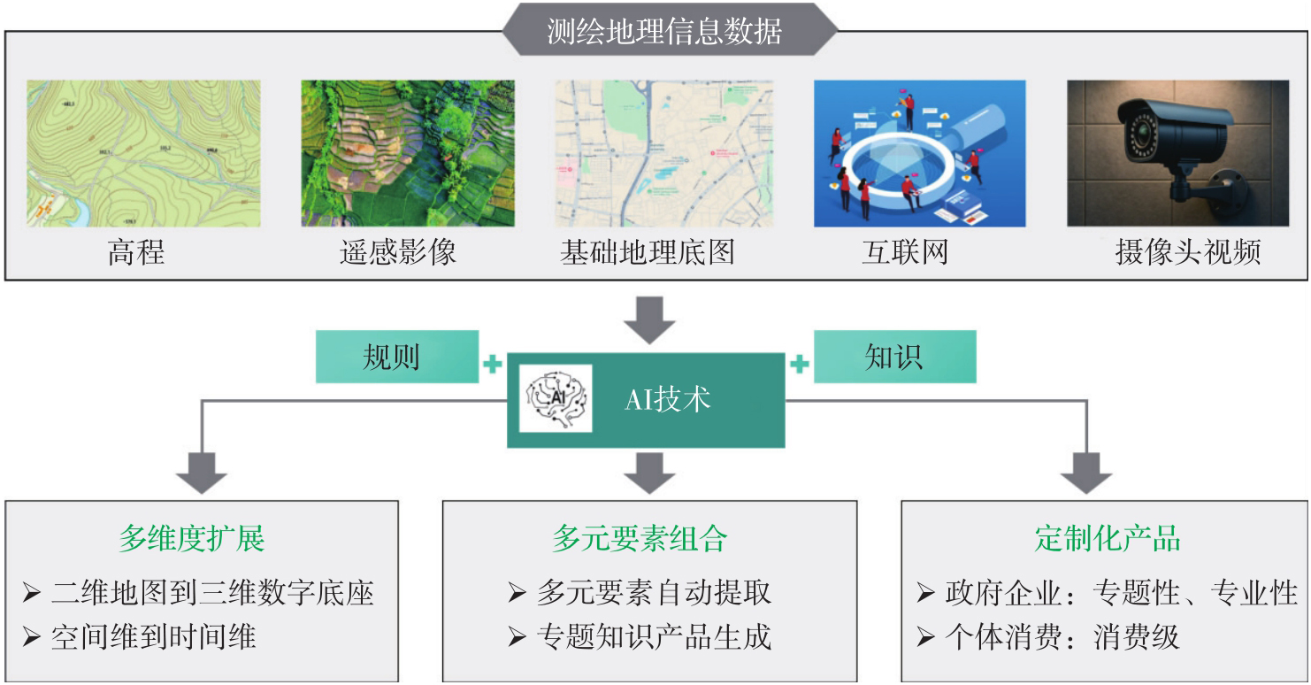
图2
构建应用场景导向的个性化技术体系"
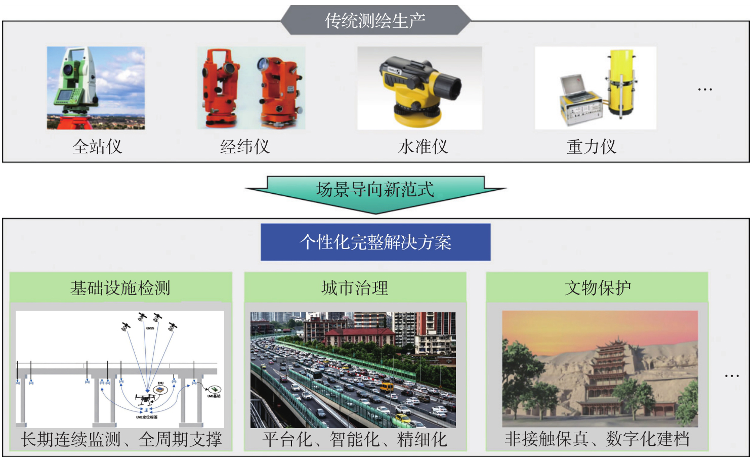
图3
测绘新公共产品"
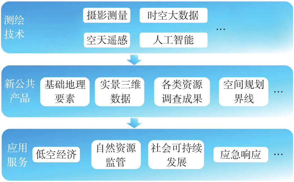
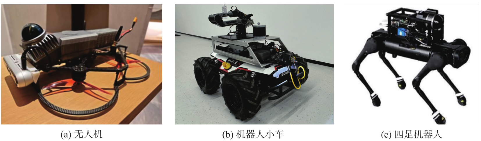
图4
常见无人自主测绘平台"
| [1] |
李德仁, 王密, 申文斌, 等. 论人工智能时代的测绘学发展[J]. 测绘学报, 2025, 54(12): 2107-2115. DOI: .
doi: 10.11947/j.AGCS.2025.20250438 |
|
LI Deren, WANG Mi, SHEN Wenbin, et al. On the development of surveying and mapping in the era of artificial intelligence[J]. Acta Geodaetica et Cartographica Sinica, 2025, 54(12): 2107-2115. DOI: .
doi: 10.11947/j.AGCS.2025.20250438 |
|
| [2] |
李德仁, 徐小迪, 邵振峰. 论万物互联时代的地球空间信息学[J]. 测绘学报, 2022, 51(1): 1-8. DOI: .
doi: 10.11947/j.AGCS.2022.20210564 |
|
LI Deren, XU Xiaodi, SHAO Zhenfeng. On geospatial information science in the era of IoE[J]. Acta Geodaetica et Cartographica Sinica, 2022, 51(1): 1-8. DOI: .
doi: 10.11947/j.AGCS.2022.20210564 |
|
| [3] | TANG Yuzhi, YANG Chao, WU Haishan, et al. Tropical forest carbon offsets deliver partial gains amid persistent over-crediting[J]. Science, 2025, 390(6769): 182-187. |
| [4] |
XU Nan, ZHANG Zihao, XU Hao, et al. Multifaceted assessment of recent saltwater intrusion along China's coasts[J/OL]. Science Bulletin, 2026, 2: 021. DOI: .
doi: 10.1016/j.scib.2026.02.021 |
| [5] | YANG Chao, ZHANG Yinghui, CHEN Min, et al. Roof greening in major Chinese cities possibly afford a large potential carbon sink[J]. Science Bulletin, 2024, 69(20): 3216-3220. |
| [6] |
李清泉, 张德津, 汪驰升, 等. 动态精密工程测量技术及应用[J]. 测绘学报, 2021, 50(9): 1147-1158. DOI: .
doi: 10.11947/j.AGCS.2021.20210172 |
|
LI Qingquan, ZHANG Dejin, WANG Chisheng, et al. Technology and applications of dynamic and precise engineering surveying[J]. Acta Geodaetica et Cartographica Sinica, 2021, 50(9): 1147-1158. DOI: .
doi: 10.11947/j.AGCS.2021.20210172 |
|
| [7] | WANG Chisheng, CHANG Ling, WANG Xiangsheng, et al. Interferometric synthetic aperture radar statistical inference in deformation measurement and geophysical inversion: a review[J]. IEEE Geoscience and Remote Sensing Magazine, 2024, 12(1): 8-35. |
| [8] |
白正伟, 张勤, 黄观文, 等. “轻终端+行业云”的实时北斗滑坡监测技术[J]. 测绘学报, 2019, 48(11): 1424-1429. DOI: .
doi: 10.11947/j.AGCS.2019.20190167 |
|
BAI Zhengwei, ZHANG Qin, HUANG Guanwen, et al. Real-time BeiDou landslide monitoring technology of “light terminal plus industry cloud”[J]. Acta Geodaetica et Cartographica Sinica, 2019, 48(11): 1424-1429. DOI: .
doi: 10.11947/j.AGCS.2019.20190167 |
|
| [9] | 李清泉, 汪驰升, 熊思婷, 等. 从几何计算到特征提取的广义测量数据处理[J]. 武汉大学学报(信息科学版), 2022, 47(11): 1805-1814. |
| LI Qingquan, WANG Chisheng, XIONG Siting, et al. Generalized surveying data processing: from geometric parameters calculation to feature information extraction[J]. Geomatics and Information Science of Wuhan University, 2022, 47(11): 1805-1814. | |
| [10] | XIA Jizhe, YE Pei, PAN Longyan, et al. Mobile phone data show spatial and socioeconomic inequalities in hospital utilization[J/OL]. Nature Health, 2026: 1-10[2026-06-05]. https://doi.org/10.1038/s44360-026-00100-6. |
| [11] | SUN Xian, WANG Peijin, LU Wanxuan, et al. RingMo: a remote sensing foundation model with masked image modeling[J]. IEEE Transactions on Geoscience and Remote Sensing, 2023, 61: 5612822. |
| [12] | 张良培, 张乐飞, 袁强强. 遥感大模型:进展与前瞻[J]. 武汉大学学报(信息科学版), 2023, 48(10): 1574-1581. |
| ZHANG Liangpei, ZHANG Lefei, YUAN Qiangqiang. Large remote sensing model: progress and prospects[J]. Geomatics and Information Science of Wuhan University, 2023, 48(10): 1574-1581. | |
| [13] | WU Kang, ZHANG Yingying, RU Lixiang, et al. A semantic-enhanced multi-modal remote sensing foundation model for Earth observation[J]. Nature Machine Intelligence, 2025, 7(8): 1235-1249. |
| [14] |
龚健雅, 许越, 胡翔云, 等. 遥感影像智能解译样本库现状与研究[J]. 测绘学报, 2021, 50(8): 1013-1022. DOI: .
doi: 10.11947/j.AGCS.2021.20210085 |
|
GONG Jianya, XU Yue, HU Xiangyun, et al. Status analysis and research of sample database for intelligent interpretation of remote sensing image[J]. Acta Geodaetica et Cartographica Sinica, 2021, 50(8): 1013-1022. DOI: .
doi: 10.11947/j.AGCS.2021.20210085 |
|
| [15] |
史文中, 张敏. 人工智能用于遥感目标可靠性识别:总体框架设计、现状分析及展望[J]. 测绘学报, 2021, 50(8): 1049-1058. DOI: .
doi: 10.11947/j.AGCS.2021.20210095 |
|
SHI Wenzhong, ZHANG Min. Artificial intelligence for reliable object recognition from remotely sensed data: overall framework design, review and prospect[J]. Acta Geodaetica et Cartographica Sinica, 2021, 50(8): 1049-1058. DOI: .
doi: 10.11947/j.AGCS.2021.20210095 |
|
| [16] | ZHANG Yifan, WEI Cheng, HE Zhengting, et al. GeoGPT: an assistant for understanding and processing geospatial tasks[J]. International Journal of Applied Earth Observation and Geoinformation, 2024, 131: 103976. |
| [17] |
杨必胜, 董震. 点云智能研究进展与趋势[J]. 测绘学报, 2019, 48(12): 1575-1585. DOI: .
doi: 10.11947/j.AGCS.2019.20190465 |
|
YANG Bisheng, DONG Zhen. Progress and perspective of point cloud intelligence[J]. Acta Geodaetica et Cartographica Sinica, 2019, 48(12): 1575-1585. DOI: .
doi: 10.11947/j.AGCS.2019.20190465 |
|
| [18] | 李德仁, 沈欣. 我国天基信息实时智能服务系统发展战略研究[J]. 中国工程科学, 2020, 22(2): 138-143. |
| LI Deren, SHEN Xin. Research on the development strategy of RealTime and intelligent space-based information service system in China[J]. Strategic Study of CAE, 2020, 22(2): 138-143. | |
| [19] |
张永军, 张祖勋, 龚健雅. 天空地多源遥感数据的广义摄影测量学[J]. 测绘学报, 2021, 50(1): 1-11. DOI: .
doi: 10.11947/j.AGCS.2021.20200245 |
|
ZHANG Yongjun, ZHANG Zuxun, GONG Jianya. Generalized photogrammetry of spaceborne, airborne and terrestrial multi-source remote sensing datasets[J]. Acta Geodaetica et Cartographica Sinica, 2021, 50(1): 1-11. DOI: .
doi: 10.11947/j.AGCS.2021.20200245 |
|
| [20] |
杨元喜. 地理空间数字孪生与时空智能[J]. 测绘学报, 2025, 54(2): 213-220. DOI: .
doi: 10.11947/j.AGCS.2025.20240515 |
|
YANG Yuanxi. Digital twin and spatio-temporal intelligence of geospatial information system[J]. Acta Geodaetica et Cartographica Sinica, 2025, 54(2): 213-220. DOI: .
doi: 10.11947/j.AGCS.2025.20240515 |
|
| [21] | 李清泉, 李德仁. 大数据GIS[J]. 武汉大学学报(信息科学版), 2014, 39(6): 641-644, 666. |
| LI Qingquan, LI Deren. Big data GIS[J]. Geomatics and Information Science of Wuhan University, 2014, 39(6): 641-644, 666. | |
| [22] | 朱建军, 宋迎春, 胡俊, 等. 测绘大数据时代数据处理理论面临的挑战与发展[J]. 武汉大学学报(信息科学版), 2021, 46(7): 1025-1031. |
| ZHU Jianjun, SONG Yingchun, HU Jun, et al. Challenges and development of data processing theory in the era of surveying and mapping big data[J]. Geomatics and Information Science of Wuhan University, 2021, 46(7): 1025-1031. | |
| [23] |
郭仁忠, 贺彪, 赵志刚, 等. 智慧城市逻辑架构与孪生平台技术需求[J]. 测绘学报, 2025, 54(5): 777-784. DOI: .
doi: 10.11947/j.AGCS.2025.20240001 |
|
GUO Renzhong, HE Biao, ZHAO Zhigang, et al. Smart city logical framework and digital-twin platform technical requirements[J]. Acta Geodaetica et Cartographica Sinica, 2025, 54(5): 777-784. DOI: .
doi: 10.11947/j.AGCS.2025.20240001 |
|
| [24] | 徐开明. 整合变化监测业务,构建“一测多用”自然资源系统测绘生产体系[M]//测绘地理信息研究报告(2025). 北京: 社会科学文献出版社, 2025. |
| XU Kaiming. Integrate change monitoring services and build a “One Survey for Multiple Uses” surveying and mapping production system in natural resources system[M]//Research report on surveying, mapping and geographic information (2025). Beijing: Social Sciences Academic Press (China), 2025. | |
| [25] | 陈军, 武昊, 刘万增. 自然资源“一张图”的技术内涵与发展方向[J]. 时空信息学报, 2026, 33(1): 1-12. |
| CHEN Jun, WU Hao, LIU Wanzeng. Technical connotation and research agenda of China's “One Map” for natural resources[J]. Journal of Spatio-Temporal Information, 2026, 33(1): 1-12. | |
| [26] | 刘春, 艾克然木·艾克拜尔, 沈雨清, 等. 时空智能驱动低空技术的测绘新质发展[J]. 测绘通报, 2026(4): 11-19. |
| LIU Chun, Akram Akbar, SHEN Yuqing, et al. Spatio-temporal intelligence-driven new-quality development of low-altitude surveying and mapping[J]. Bulletin of Surveying and Mapping, 2026(4): 11-19. |
| [1] | 刘万增, 陈军, 章炜. 论地理信息保密的技术逻辑[J]. 测绘学报, 2026, 55(5): 826-837. |
| [2] | 周旭升, 谭永滨, 于忠海, 王维, 肖青云. 融合矢量结构特征的复杂建筑物形状识别方法[J]. 测绘学报, 2026, 55(5): 838-849. |
| [3] | 张亚. 联合POI语义和空间形态特征的城市建筑物功能分类方法研究[J]. 测绘学报, 2026, 55(5): 948-948. |
| [4] | 吴明光, 成梓铭. 顾及使用场景的绿色地图颜色生成方法研究[J]. 测绘学报, 2026, 55(3): 390-403. |
| [5] | 杨敏, 马宏然, 孔博, 刘鹏程, 艾廷华. 基于预训练模型的矢量海岸线形态模式判别方法[J]. 测绘学报, 2026, 55(3): 404-414. |
| [6] | 禹文豪, 曾子怡, 张一帆, 钱海忠. 融合欧氏空间邻近与拓扑邻接信息预训练模型的路网网格模式[J]. 测绘学报, 2026, 55(3): 415-424. |
| [7] | 禄小敏, 张志义, 闫浩文, 何毅, 苏小宁. 融合深度图信息最大化和多层感知机的建筑物群组模式识别方法[J]. 测绘学报, 2026, 55(3): 425-438. |
| [8] | 于永灿, 赵建虎, 李冰墨, 贺子扬. 侧扫声呐图像目标识别模型类增量更新方法[J]. 测绘学报, 2026, 55(3): 502-514. |
| [9] | 成晓强, 赵家威, 刘鹏程. 基于距离-相似性隐喻的空间交互可视化[J]. 测绘学报, 2026, 55(3): 536-547. |
| [10] | 王泽矫, 向隆刚, 王猛, 王兴娟, 刘清. 融合层级特征与多样化注意力的道路面与中心线协同提取网络[J]. 测绘学报, 2026, 55(3): 548-563. |
| [11] | 徐智邦. 实体城市的多层次边界识别、模式分析与扩张模拟[J]. 测绘学报, 2026, 55(3): 566-566. |
| [12] | 冉耘博, 杨雪, 周文豪, 吴承恩, 周宝定, 唐炉亮, 李清泉. 多维偏好增强型对抗深度强化学习驱动的行人路径规划[J]. 测绘学报, 2026, 55(2): 191-205. |
| [13] | 王立增, 程诗奋, 杨一涛, 王培晓, 陆锋. 局部-全局联合感知的时空自适应交通集成预测方法[J]. 测绘学报, 2026, 55(2): 206-221. |
| [14] | 王少华, 梁浩健, 苏澄, 徐大川, 周亮, 秦昆. 耦合时空大数据和人工智能的城市设施配置优化研究进展与展望[J]. 测绘学报, 2026, 55(2): 222-235. |
| [15] | 付晓, 朱司蕊, 厉旭东, 闾国年. 面向长距离通勤场景的城市垂直起降场布局优化方法[J]. 测绘学报, 2026, 55(2): 236-248. |
| 阅读次数 | ||||||
|
全文 |
|
|||||
|
摘要 |
|
|||||
