


测绘学报 ›› 2026, Vol. 55 ›› Issue (6): 990-1002.doi: 10.11947/j.AGCS.2026.20250489
• 影像大地测量前沿技术与智慧防灾创新应用 • 上一篇
刘骐1,2( ), 余琛1,3,4(), 李振洪1,3,4, 宋闯1,3,4, 胡晓宁1,2, 李杰1,2, 胡腾辉1,2
收稿日期:2025-11-19
修回日期:2026-06-05
发布日期:2026-07-28
通讯作者:
余琛
E-mail:liuqi2002@chd.edu.cn;chen.yu@chd.edu.cn
作者简介:刘骐(2002—),男,博士生,研究方向为洪水监测与InSAR形变监测。E-mail:liuqi2002@chd.edu.cn
基金资助:
Qi LIU1,2(), Chen YU1,3,4(), Zhenhong LI1,3,4, Chuang SONG1,3,4, Xiaoning HU1,2, Jie LI1,2, Tenghui HU1,2
Received:2025-11-19
Revised:2026-06-05
Published:2026-07-28
Contact:
Chen YU
E-mail:liuqi2002@chd.edu.cn;chen.yu@chd.edu.cn
About author:LIU Qi (2002—), male, PhD candidate, majors in flood monitoring and InSAR deformation monitoring. E-mail: liuqi2002@chd.edu.cn
Supported by:摘要:
垃圾填埋场在封场后仍会长期经历由生物降解与压缩引起的持续沉降,其空间差异性强、时序特征复杂,在当前城市固废处置设施向更加安全、长效管理模式转型的背景下,填埋场封场后的地表沉降演化规律变得尤为重要,迫切需要地表形变监测与风险评估。本文以曾为亚洲单体处理规模最大的广东兴丰生活垃圾填埋场为例,整合Envisat和Sentinel-1数据,利用偏移量追踪技术对不同卫星数据处理以补全数据空缺期形变,结合小基线集技术构建了18年的长时间形变序列,并对其未来形变趋势进行了预测。监测结果显示了显著的空间不均匀沉降现象,且不均匀程度与填埋工艺、填埋废物类型高度相关,东部生活垃圾填埋区地面沉降剧烈(2008—2025年间累积沉降4.4 m),西部应急填埋区地表变化相对稳定(2008—2025年间累积沉降1.9 m)。填埋场沉降与气候因子呈现较强相关性,沉降存在3~4个月的时滞效应,揭示了气候变化对填埋场地表稳定性的控制作用。形变预测结果显示未来较长一段时间内,填埋场仍将处于不均匀沉降状态,其中,东部填埋区需8~10年达到地表稳定,西部填埋区则需5年达到地表稳定。本文通过长时序形变监测实现垃圾填埋场全周期形变特征识别,并利用形变分解对各分区的形变特征进行量化;基于ConvLSTM模型,对填埋场未来形变、风险特征及地表稳定时间进行评估,可为类似填埋场的长时序全周期地表形变与风险评估提供参考。
中图分类号:
刘骐, 余琛, 李振洪, 宋闯, 胡晓宁, 李杰, 胡腾辉. 超大型垃圾填埋场长时序不均匀沉降监测与风险预测[J]. 测绘学报, 2026, 55(6): 990-1002.
Qi LIU, Chen YU, Zhenhong LI, Chuang SONG, Xiaoning HU, Jie LI, Tenghui HU. Long-term uneven subsidence monitoring and risk prediction of ultra-large garbage landfills[J]. Acta Geodaetica et Cartographica Sinica, 2026, 55(6): 990-1002.
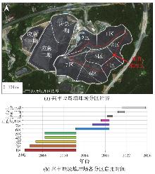
图1
研究区分区边界及各分区使用时间表"
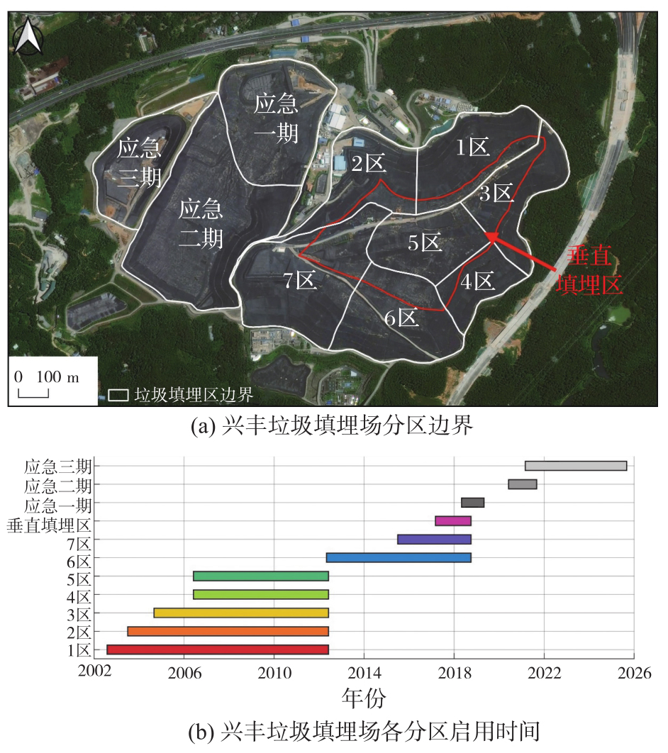

表1
研究区影像数据参数"
| 卫星 | 轨道 | 极化方式 | 成像模式 | 开始日期 | 截止日期 | 影像数量 |
|---|---|---|---|---|---|---|
| Envisat | 升轨 | VV | IM | 2008-01-07 | 2010-09-26 | 33 |
| Sentinel-1 | 升轨 | VV | IW | 2015-06-15 | 2025-05-17 | 273 |
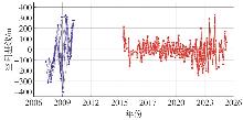
图2
SBAS-InSAR时空基线注:蓝色部分为Envisat卫星时空基线,红色部分为Sentinel-1卫星时空基线"
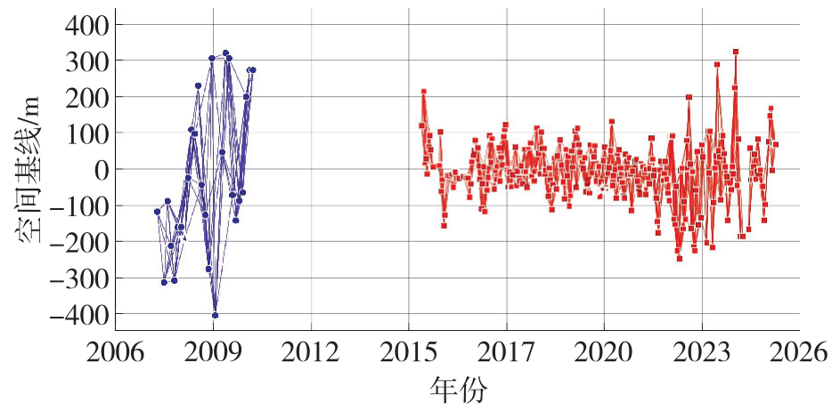
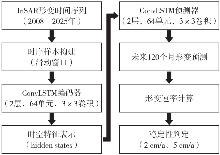
图3
模型流程"
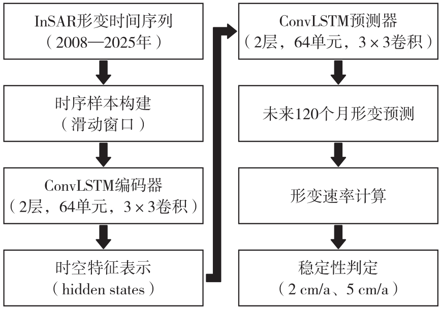
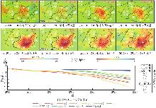
图4
垂直形变速率及形变量"

表2
特征点大气校正前后时序标准差对比"
| 点名 | P11 | P12 | P13 | P14 | P15 | P16 | P17 | P21 | P22 | P23 |
|---|---|---|---|---|---|---|---|---|---|---|
| 标准差 | 99.28 | 140.33 | 111.12 | 153.59 | 204.63 | 175.86 | 104.28 | 56.86 | 38.24 | 21.70 |
| 标准差(校正) | 36.71 | 76.24 | 81.95 | 114.64 | 170.27 | 151.39 | 84.91 | 55.96 | 33.25 | 17.35 |
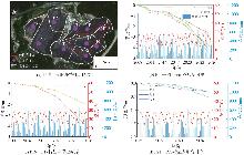
图5
填埋场地表形变时序特征"

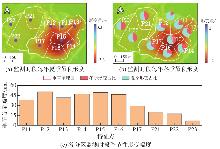
图6
季节性形变与形变幅度"
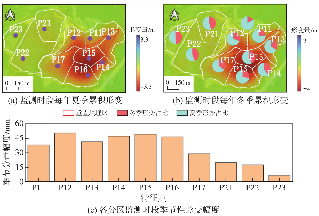
表3
形变时序和气候变化相关性与时滞"
| 特征点 | 温度相关性(Pearson系数) | 温度相关性(Spearman系数) | 降水相关性(Pearson系数) | 降水相关性(Spearman系数) | 温度时滞/d | 降水时滞/d |
|---|---|---|---|---|---|---|
| P11 | 0.72 | 0.68 | 0.69 | 0.64 | 115 | 108 |
| P12 | 0.75 | 0.81 | 0.74 | 0.82 | 124 | 104 |
| P13 | 0.76 | 0.63 | 0.79 | 0.58 | 105 | 106 |
| P14 | 0.69 | 0.74 | 0.64 | 0.69 | 111 | 118 |
| P15 | 0.66 | 0.59 | 0.69 | 0.54 | 115 | 124 |
| P16 | 0.59 | 0.71 | 0.61 | 0.67 | 118 | 132 |
| P17 | 0.62 | 0.56 | 0.57 | 0.52 | 101 | 99 |
| P21 | 0.58 | 0.66 | 0.59 | 0.73 | 132 | 114 |
| P22 | 0.64 | 0.78 | 0.54 | 0.76 | 119 | 110 |
| P23 | 0.53 | 0.61 | 0.51 | 0.49 | 119 | 124 |
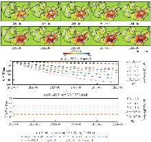
图7
填埋场时序预测特征"

表4
预测精度验证结果"
| 模型 | RMSE/mm | R2 |
|---|---|---|
| ConvLSTM | 21.2 | 0.892 |
| LSTM | 25.8 | 0.831 |
| GRU | 26.4 | 0.816 |
| Transformer | 28.2 | 0.789 |
| ARIMA | 32.5 | 0.724 |
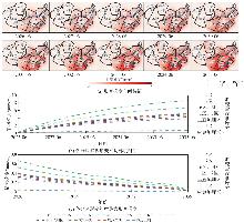
图8
填埋场时序预测梯度特征"
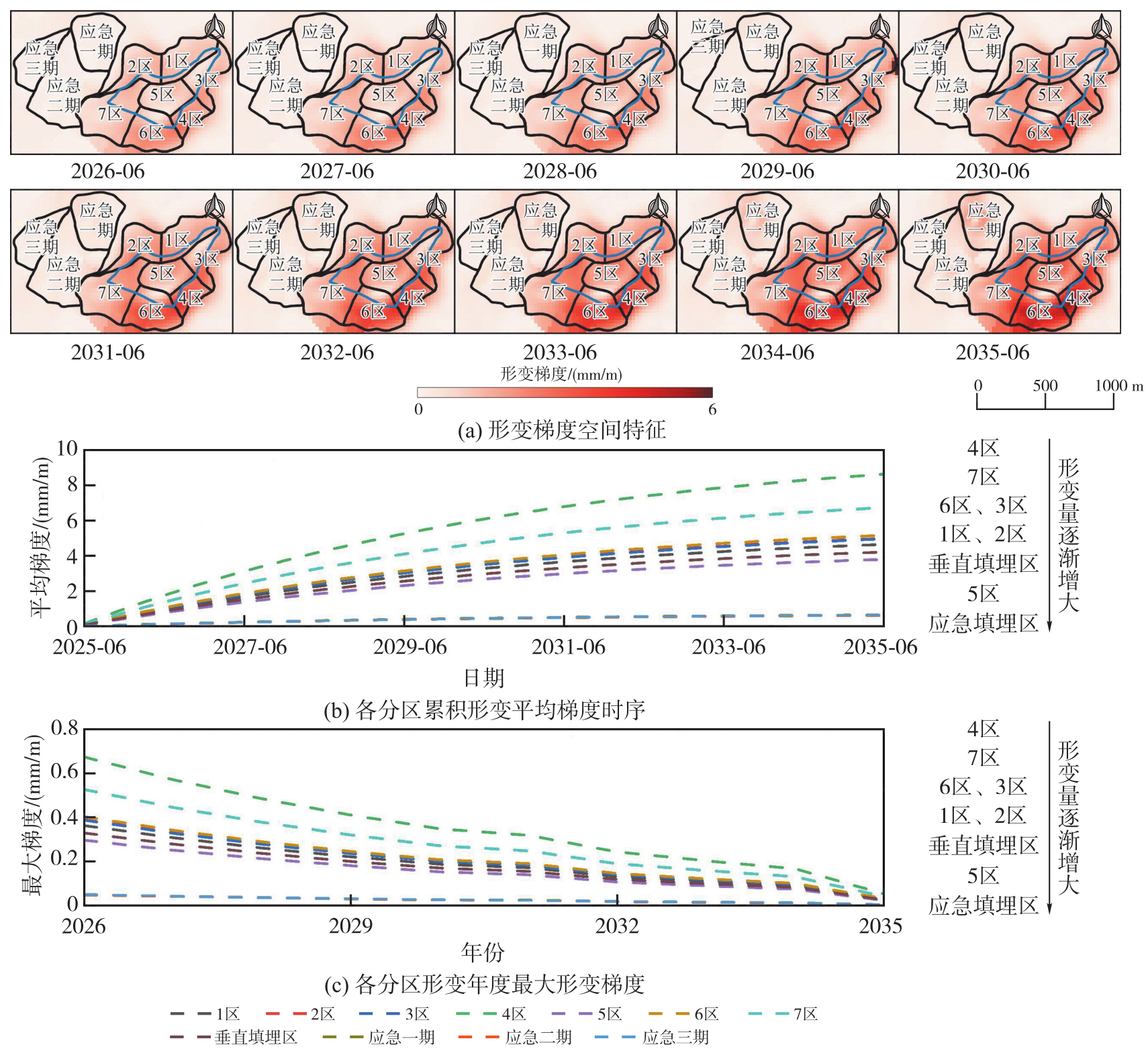
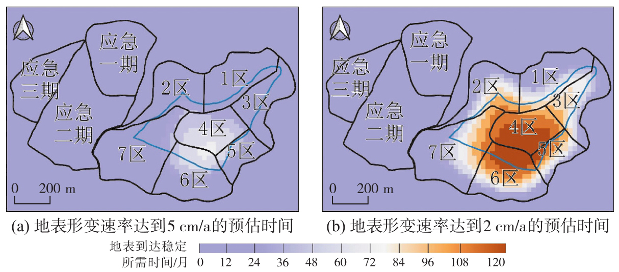
图9
填埋场地表稳定时间"
| [1] | 戴福初, 李军, 张晓晖. 城市建设用地与地质环境协调性评价的GIS方法及其应用[J]. 地球科学, 2000, 25(2): 209-214. |
| DAI Fuchu, LI Jun, ZHANG Xiaohui. GIS methodology and its application to evaluation of coordination between urban land use and geo-environmental potential[J]. Earth Science, 2000, 25(2): 209-214. | |
| [2] | 袁文祥, 陈善平, 邰俊, 等. 我国垃圾填埋场现状、问题及发展对策[J]. 环境卫生工程, 2016, 24(5): 8-11. |
| YUAN Wenxiang, CHEN Shanping, TAI Jun, et al. Present situation, problems and development countermeasures of landfill in China[J]. Environmental Sanitation Engineering, 2016, 24(5): 8-11. | |
| [3] | 宋薇, 吴彬彬, 陶其阳. 我国生活垃圾填埋场封场后管理现状与建议[J]. 环境卫生工程, 2018, 26(2): 73-75, 79. |
| SONG Wei, WU Binbin, TAO Qiyang. Status and suggestion on post-closure management of municipal solid waste landfill in China[J]. Environmental Sanitation Engineering, 2018, 26(2): 73-75, 79. | |
| [4] | MOR S, RAVINDRA K. Municipal solid waste landfills in lower-and middle-income countries: environmental impacts, challenges and sustainable management practices[J]. Process Safety and Environmental Protection, 2023, 174: 510-530. |
| [5] | IQBAL A, LIU X M, CHEN G H. Municipal solid waste: review of best practices in application of life cycle assessment and sustainable management techniques[J]. Science of the Total Environment, 2020, 729: 138622. |
| [6] | ZHANG Shuai, LÜ Yunhong, YANG Haiben, et al. Monitoring and quantitative human risk assessment of municipal solid waste landfill using integrated satellite-UAV-ground survey approach[J]. Remote Sensing, 2021, 13(22): 4496. |
| [7] | WALL D K, ZEISS C. Municipal landfill biodegradation and settlement[J]. Journal of Environmental Engineering, 1995, 121(3): 214-224. |
| [8] | HOSSAIN M S, GABR M A, BARLAZ M A. Relationship of compressibility parameters to municipal solid waste decomposition[J]. Journal of Geotechnical and Geoenvironmental Engineering, 2003, 129(12): 1151-1158. |
| [9] | DUAN Z H, SCHEUTZ C, KJELDSEN P. Trace gas emissions from municipal solid waste landfills: a review[J]. Waste Management, 2021, 119: 39-62. |
| [10] | ZHANG Xiwen, SONG Jing, PENG Jian, et al. Landslides-oriented urban disaster resilience assessment: a case study in ShenZhen, China[J]. Science of the Total Environment, 2019, 661: 95-106. |
| [11] | KE Han, MA Pengcheng, LAN Jiwu, et al. Field behaviors of a geogrid reinforced MSW slope in a high-food-waste-content MSW landfill: a case study[J]. Geotextiles and Geomembranes, 2021, 49(2): 430-441. |
| [12] | NANDA S, BERRUTI F. Municipal solid waste management and landfilling technologies: a review[J]. Environmental Chemistry Letters, 2021, 19(2): 1433-1456. |
| [13] | MA Shijun, ZHOU Chuanbin, PAN Jingjin, et al. Leachate from municipal solid waste landfills in a global perspective: characteristics, influential factors and environmental risks[J]. Journal of Cleaner Production, 2022, 333: 130234. |
| [14] | 王罗春, 赵由才, 陆雍森. 垃圾填埋场稳定化评价[J]. 环境卫生工程, 2001, 9(4): 157-159, 166. |
| WANG Luochun, ZHAO Youcai, LU Yongsen. Evaluating of refuse landfill site stabilization[J]. Environmental Sanitation Engineering, 2001, 9(4): 157-159, 166. | |
| [15] | KWARTENG A Y, AL-ENEZI A. Assessment of Kuwait's Al-qurain landfill using remotely sensed data[J]. Journal of Environmental Science and Health, Part A, 2004, 39(2): 351-364. |
| [16] | AL-YAQOUT A F, HAMODA M F, ZAFAR M. Characteristics of wastes, leachate, and gas at landfills operated in arid climate[J]. Practice Periodical of Hazardous, Toxic, and Radioactive Waste Management, 2005, 9(2): 97-102. |
| [17] | XIE Y K, XUE J F. Quantifying the long-term settlement of municipal solid wastes in landfills based on global navigation satellite system[C]//Proceedings of the 9th International Conference on Environmental Geotechnics. Chania: ISSMGE, 2023: 451. |
| [18] | ADAMCOVÁ D, BARTON S, OSINSKI P, et al. Analytical modelling of MSW landfill surface displacement based on GNSS monitoring[J]. Sensors, 2020, 20(21): 5998. |
| [19] | BAEK W K, JUNG H S, JO M J, et al. Ground subsidence observation of solid waste landfill park using multi-temporal radar interferometry[J]. International Journal of Urban Sciences, 2019, 23(3): 406-421. |
| [20] | DU Yanan, FU Haiqiang, LIU Lin, et al. Continued monitoring and modeling of Xingfeng solid waste landfill settlement, China, based on multiplatform SAR images[J]. Remote Sensing, 2021, 13(16): 3286. |
| [21] | 李晨程, 江利明, 吴宇轩, 等. 基于时序InSAR技术的武汉大型垃圾填埋场形变监测与分析[J]. 武汉大学学报(信息科学版), 2025, 50(8): 1694-1704. |
| LI Chencheng, JIANG Liming, WU Yuxuan, et al. Monitoring ground displacement of large-scale landfills in Wuhan using time-series InSAR technology[J]. Geomatics and Information Science of Wuhan University, 2025, 50(8): 1694-1704. | |
| [22] | 史绪国, 徐金虎, 蒋厚军, 等. 时序InSAR技术三峡库区藕塘滑坡稳定性监测与状态更新[J]. 地球科学, 2019, 44(12): 4284-4292. |
| SHI Xuguo, XU Jinhu, JIANG Houjun, et al. Slope stability state monitoring and updating of the Outang landslide, Three Gorges area with time series InSAR analysis[J]. Earth Science, 2019, 44(12): 4284-4292. | |
| [23] | SONG Chuang, YU Chen, LI Zhenhong, et al. Triggering and recovery of earthquake accelerated landslides in central Italy revealed by satellite radar observations[J]. Nature Communications, 2022, 13: 7278. |
| [24] | GONZÁLEZ F. InSAR-based mapping of ground deformation caused by industrial waste disposals: the case study of the Huelva phosphogypsum stack, SW Spain[J]. Bulletin of Engineering Geology and the Environment, 2022, 81(8): 304. |
| [25] | EMIL M K, SULTAN M, ALAKHRAS K, et al. Countrywide monitoring of ground deformation using InSAR time series: a case study from Qatar[J]. Remote Sensing, 2021, 13(4): 702. |
| [26] | GABRIEL A K, GOLDSTEIN R M, ZEBKER H A. Mapping small elevation changes over large areas: differential radar interferometry[J]. Journal of Geophysical Research: Solid Earth, 1989, 94(B7): 9183-9191. |
| [27] | 刘国祥. InSAR原理与应用[M]. 北京: 科学出版社, 2019. |
| LIU Guoxiang. Principle and application of InSAR[M]. Beijing: Science Press, 2019. | |
| [28] | YU C, LI Z H, PENNA N T. Triggered afterslip on the southern Hikurangi subduction interface following the 2016 Kaikōura earthquake from InSAR time series with atmospheric corrections[J]. Remote Sensing of Environment, 2020, 251: 112097. |
| [29] | BERARDINO P, FORNARO G, LANARI R, et al. A new algorithm for surface deformation monitoring based on small baseline differential SAR interferograms[J]. IEEE Transactions on Geoscience and Remote Sensing, 2002, 40(11): 2375-2383. |
| [30] | LI Z, YU C, XIAO R, et al. Entering a new era of InSAR: advanced techniques and emerging applications[J]. Journal of Geodesy and Geoinformation Science, 2022, 5(1): 1-4. |
| [31] | GOLDSTEIN R M, WERNER C L. Radar interferogram filtering for geophysical applications[J]. Geophysical Research Letters, 1998, 25(21): 4035-4038. |
| [32] | JIACHENG X, XIUFENG H, STEIN A, et al. Deformation monitoring of the embankments using multitemporal InSAR: a case study of the Kangshan embankment[J]. Journal of Geodesy and Geoinformation Science, 2025, 8(1): 12-29. |
| [33] | YU C, LI Z H, PENNA N T. Interferometric synthetic aperture radar atmospheric correction using a GPS-based iterative tropospheric decomposition model[J]. Remote Sensing of Environment, 2018, 204: 109-121. |
| [34] | YU C, LI Z H, PENNA N T, et al. Generic atmospheric correction model for interferometric synthetic aperture radar observations[J]. Journal of Geophysical Research: Solid Earth, 2018, 123(10): 9202-9222. |
| [35] | COSTANTINI M. A novel phase unwrapping method based on network programming[J]. IEEE Transactions on Geoscience and Remote Sensing, 1998, 36(3): 813-821. |
| [36] | LI Jia, LI Zhiwei, DING Xiaoli, et al. Investigating mountain glacier motion with the method of SAR intensity-tracking: removal of topographic effects and analysis of the dynamic patterns[J]. Earth-Science Reviews, 2014, 138: 179-195. |
| [37] | LIU Xiaojie, ZHAO Chaoying, ZHANG Qin, et al. Deformation of the Baige landslide, Tibet, China, revealed through the integration of cross-platform ALOS/PALSAR-1 and ALOS/PALSAR-2 SAR observations[J]. Geophysical Research Letters, 2020, 47(3): e2019GL086142. |
| [38] | YIN Yueping, LIU Xiaojie, ZHAO Chaoying, et al. Multi-dimensional and long-term time series monitoring and early warning of landslide hazard with improved cross-platform SAR offset tracking method[J]. Science China Technological Sciences, 2022, 65(8): 1891-1912. |
| [39] | 刘晓杰. 星载雷达遥感广域滑坡早期识别与监测预测关键技术研究[D]. 西安: 长安大学, 2022. |
| LIU Xiaojie. Research on key technologies for early identification, monitoring and forecasting of wide-area landslides with spaceborne radar remote sensing[D]. Xi'an: Changan University, 2022. | |
| [40] | 胡敏云, 陈云敏, 温振统. 城市垃圾填埋场垃圾土压缩变形的研究[J]. 岩土工程学报, 2001, 23(1): 123-126. |
| HU Minyun, CHEN Yunmin, WEN Zhentong. Study on compression deformation of waste soil in municipal solid waste landfill[J]. Chinese Journal of Geotechnical Engineering, 2001, 23(1): 123-126. | |
| [41] | ZEKKOS D, DATA S, FEI X C. Coupled process modeling for energy generation from municipal solid waste degradation: Laboratory-scale and field-scale simulations[J]. Japanese Geotechnical Society Special Publication, 2021, 9(11): 485-503. |
| [42] | 柯瀚, 刘骏龙, 陈云敏, 等. 不同压力下垃圾降解压缩试验研究[J]. 岩土工程学报, 2010, 32(10): 1610-1615. |
| KE Han, LIU Junlong, CHEN Yunmin, et al. Biodegradation-compression tests on municipal solid waste subjected to different vertical pressures[J]. Chinese Journal of Geotechnical Engineering, 2010, 32(10): 1610-1615. | |
| [43] | 罗袆沅, 许强, 蒋亚楠, 等. 基于时序InSAR与机器学习的大范围地面沉降预测方法[J]. 地球科学, 2024, 49(5): 1736-1745. |
| LUO Yiyuan, XU Qiang, JIANG Yanan, et al. The prediction method of large-scale land subsidence based on multi-temporal InSAR and machine learning[J]. Earth Science, 2024, 49(5): 1736-1745. | |
| [44] | SHI Xingjian, CHEN Zhourong, WANG Hao, et al. Convolutional LSTM network: a machine learning approach for precipitation nowcasting[J]. Advances in neural information processing systems, 2015, 28: 6352419. |
| [45] | 国家质量监督检验检疫总局, 中国国家标准化管理委员会. 生活垃圾填埋场稳定化场地利用技术要求:GB/T 25179—2010[S]. 北京: 中国标准出版社, 2011. |
| General Administration of Quality Supervision, Inspection and Quarantine of the People's Republic of China, Standardization Administration of the People's Republic of China. Technical requirements for site utilization after stabilization in municipal solid waste landfill: GB/T 25179—2010[S]. Beijing: Standards Press of China, 2011. | |
| [46] | 国家市场监督管理总局, 国家标准化管理委员会. 地质灾害危险性评估规范:GB/T 40112—2021[S]. 北京: 中国标准出版社, 2021. |
| State Administration for Market Regulation, Standardization Administration of the People's Republic of China. Specifications for risk assessment of geological hazard: GB/T 40112—2021[S]. Beijing: Standards Press of China, 2021. | |
| [47] | SHIN Y, LEE H. Subsidence of a coal ash landfill in a power plant observed by applying PSInSAR to Sentinel-1 SAR data[J]. Remote Sensing, 2023, 15(17): 4127. |
| [1] | 高二涛, 刘静, 李淑瑾, 周国清, 付波霖, 李淑娴. 光学遥感与SAR协同的茅尾海潮滩多维时空演变监测与分析[J]. 测绘学报, 2026, 55(4): 632-646. |
| [2] | 路中, 赵金奇, 牛玉芬, 陈立权, 樊茜佑, 司锦钊, 王子璇, 高源, 王帅, 曲菲霏, 时洪涛, 闫世勇, 师芸, 赵争. NISAR卫星对地观测革新及其在地表形变监测中的应用[J]. 测绘学报, 2026, 55(2): 261-274. |
| [3] | 李鹏, 白建博, 李振洪, 王厚杰. 融合多轨道TS-InSAR的广域海岸带地面沉降监测及成因解析——以山东省为例[J]. 测绘学报, 2025, 54(7): 1178-1191. |
| [4] | 杜钊锋, 李国鹏, 刘站科, 尚夏明, 康胜军, 王晓强. 国家重点沉降区域多监测手段综合分析[J]. 测绘学报, 2025, 54(3): 481-492. |
| [5] | 陈海禄, 沈云中. GNSS辅助下的InSAR对流层延迟垂直分层与湍流分量联合改正模型[J]. 测绘学报, 2025, 54(10): 1786-1797. |
| [6] | 江利明, 邵益, 周志伟, 马培峰, 王腾. 智能化InSAR数据处理研究进展、挑战与展望[J]. 测绘学报, 2024, 53(6): 1037-1056. |
| [7] | 周苍海, 田镇, 石震, 托坎哈衣那尔·. 时序InSAR与GNSS联合约束下的亚东-谷露断裂运动特征[J]. 测绘学报, 2024, 53(5): 933-945. |
| [8] | 朱珺, 彭葳, 付海强, 欧蔓, 雷缮诚, 张石平. 观测信息不足条件下TanDEM-X InSAR的大范围林下地形反演[J]. 测绘学报, 2024, 53(5): 959-966. |
| [9] | 高延东, 贾义琨, 李世金, 陈宇, 李怀展, 郑南山, 张书毕. InSAR相位解缠最大流/最小割权值改进算法[J]. 测绘学报, 2024, 53(4): 644-652. |
| [10] | 何毅, 杨旺, 朱庆. 基于R2AU-Net的InSAR相位解缠方法[J]. 测绘学报, 2024, 53(3): 435-449. |
| [11] | 王媛, 徐华平, 李春升, 曾国兵, 刘爱芳, 葛仕奇. 星载分布式SAR双频乒乓模式测高精度分析[J]. 测绘学报, 2024, 53(3): 463-472. |
| [12] | 岳佳伟, 黄其欢, 刘辉, 马张烽. 离散优化框架下的多基线InSAR相位解缠方法[J]. 测绘学报, 2024, 53(3): 473-481. |
| [13] | 宋鑫友, 张磊, 李涛, 雷宝成, 宋瑞庆. 陆探一号干涉SAR在轨测试阶段基线精化与DEM精度分析[J]. 测绘学报, 2024, 53(10): 1920-1929. |
| [14] | 许兵, 朱焱, 李志伟, 易辉伟, 胡妙文, 陈琦, 韩焜, 杜洵. 国产卫星时序InSAR形变监测精度分析[J]. 测绘学报, 2024, 53(10): 1930-1941. |
| [15] | 林东方, 姚宜斌, 郑敦勇, 廖孟光, 谢建. 利用均方误差相对变化规律确定正则化参数及其在PolInSAR测量反演中的应用[J]. 测绘学报, 2023, 52(9): 1480-1491. |
| 阅读次数 | ||||||
|
全文 |
|
|||||
|
摘要 |
|
|||||
