

Acta Geodaetica et Cartographica Sinica ›› 2024, Vol. 53 ›› Issue (4): 653-665.doi: 10.11947/j.AGCS.2024.20230044
• Geodesy and Navigation • Previous Articles Next Articles
Tian HE1( ), Guojie MENG1(), Weiwei WU1, Xiaoning SU2, Guoqiang ZHAO1,3, Congmin WEI1,4, Zhihua DONG1,4
Received:2023-02-21
Revised:2023-07-01
Published:2024-05-13
Contact:
Guojie MENG
E-mail:2269566647@qq.com;mgj@ief.ac.cn
About author:HE Tian (1997—), male, postgraduate, majors in precise processing of GNSS data and current crustal deformation. E-mail: 2269566647@qq.com
Supported by:CLC Number:
Tian HE, Guojie MENG, Weiwei WU, Xiaoning SU, Guoqiang ZHAO, Congmin WEI, Zhihua DONG. Preliminary analysis to positioning precision and crustal movement of BDS-3 data recorded by the China seismic experiment site[J]. Acta Geodaetica et Cartographica Sinica, 2024, 53(4): 653-665.

Fig. 1
The seismotectonics of the Sichuan-Yunnan region"
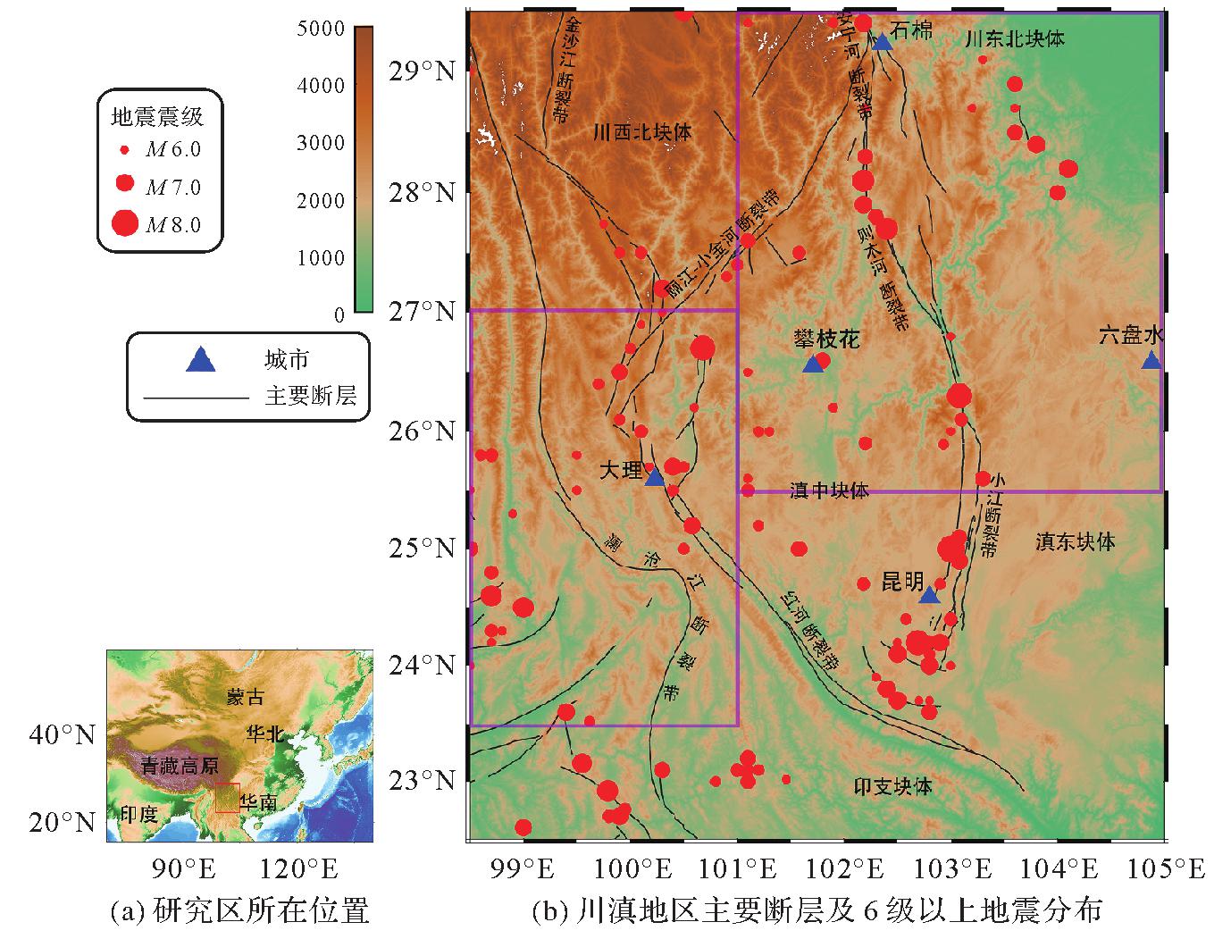
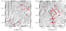
Fig. 2
Distribution of BDS-3 stations in China seismic experimental site"

Fig. 3
BDS-3 data time span for China seismic experimental site used in this study"
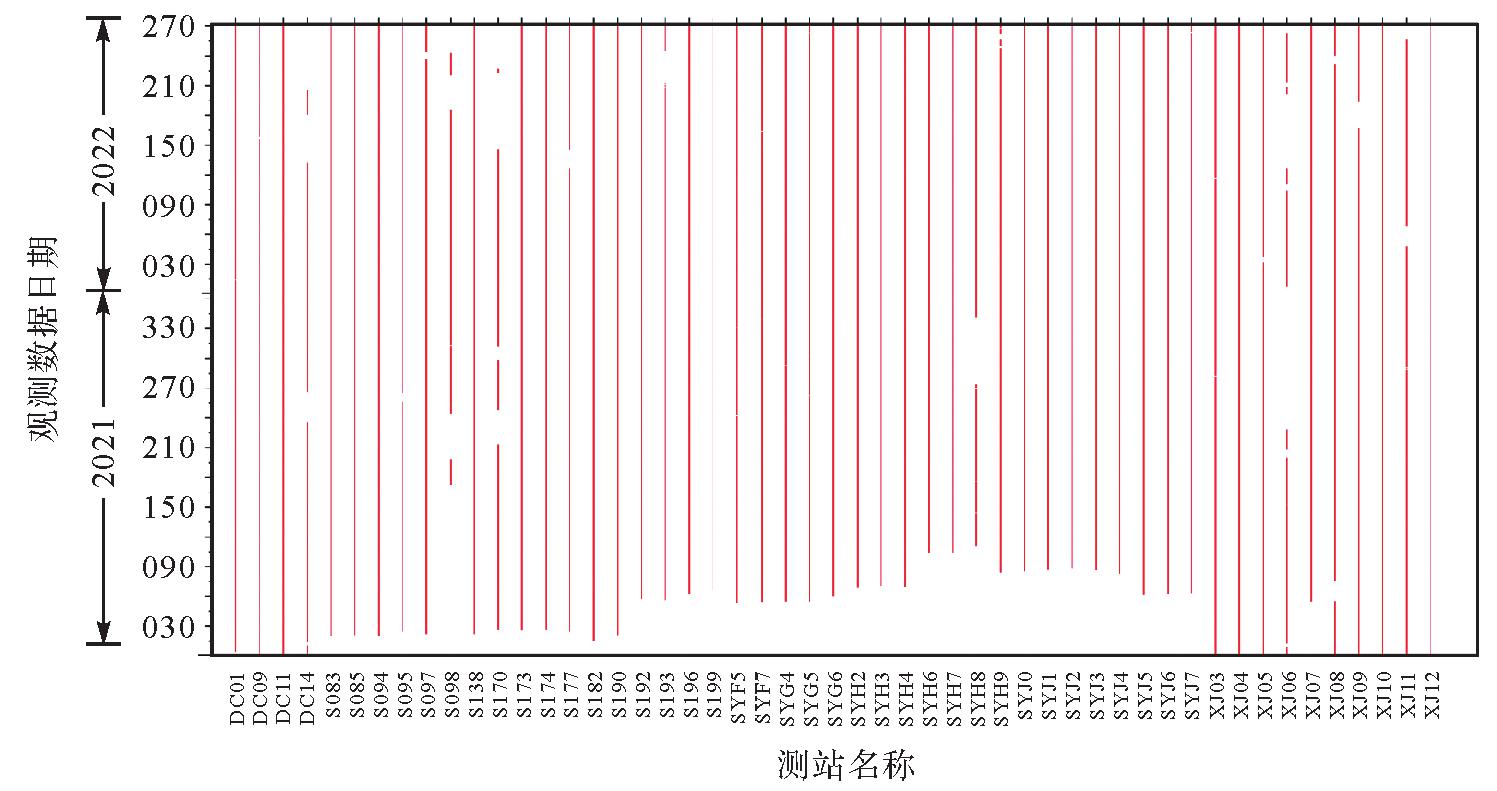
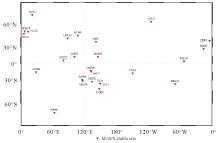
Fig. 4
Spatial global distribution of MGEX stations"
Fig. 5
The data quality of C37 satellite of BDS-3 at the station S083 on DOY 305 of 2021"
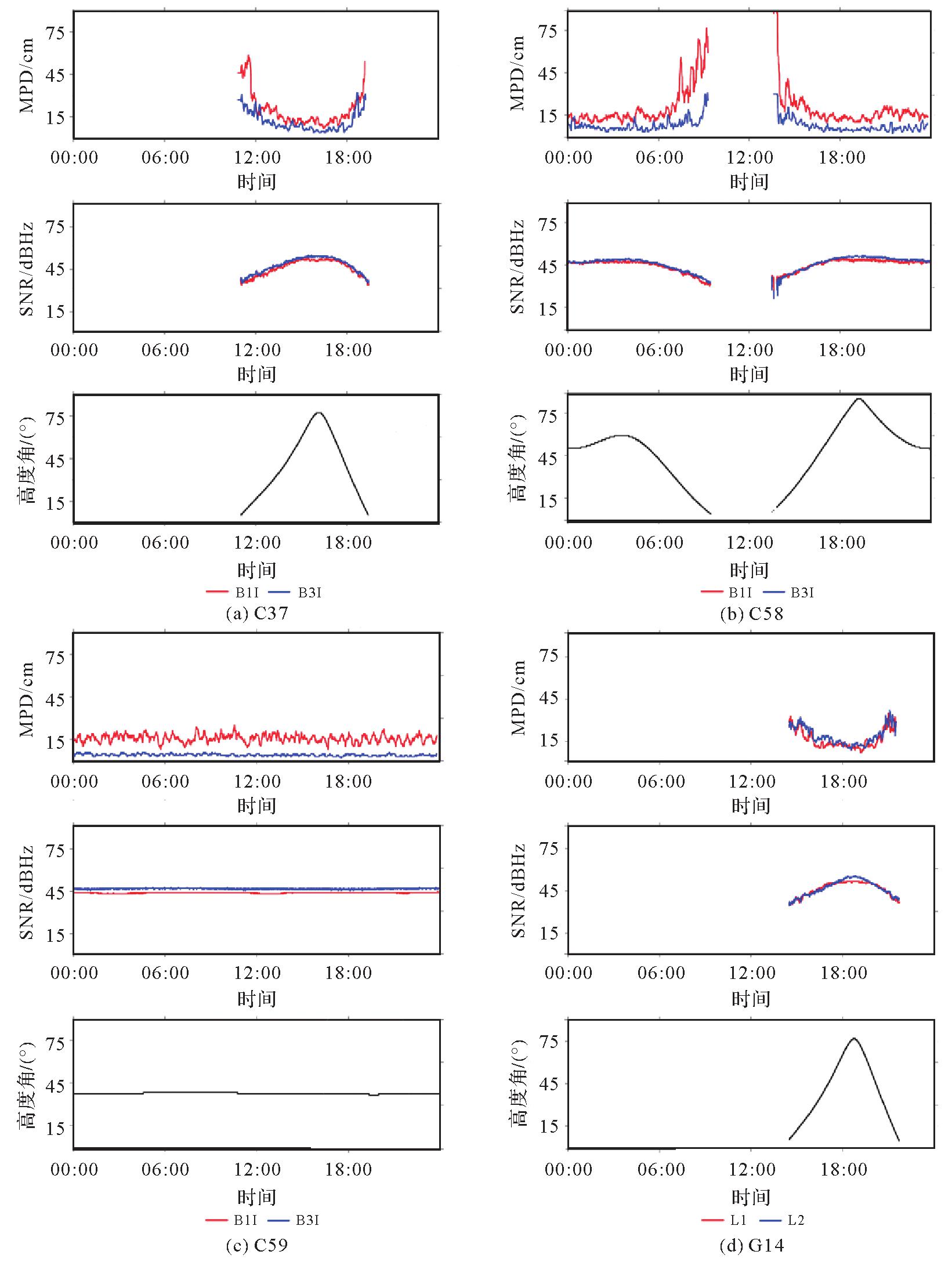
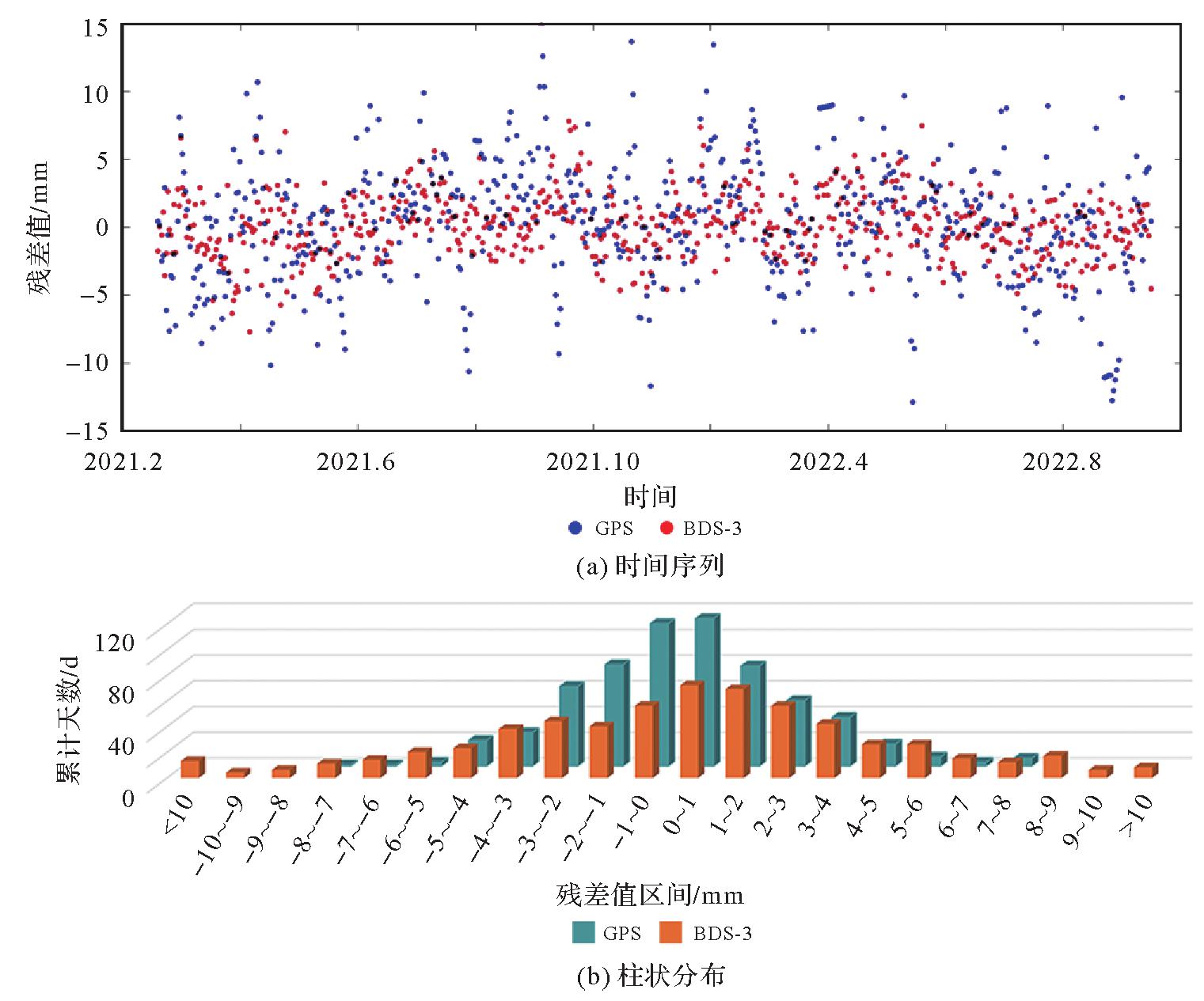
Fig. 6
Residual time series in the N direction of station S083 for BDS-3 and GPS, respectively"
Tab. 1
The average RMS values of the coordinate residual time series of for all stations derived from BDS-3 and GPS observations"
| 星座 | N | E | U |
|---|---|---|---|
| BDS | 4.42 | 4.26 | 8.34 |
| GPS | 2.65 | 3.19 | 7.39 |
Tab. 2
The precision of 3D velocity fields from BDS-3 and GPS observations"
| 星座 | N | E | U |
|---|---|---|---|
| BDS | 3.03 | 1.64 | 4.47 |
| GPS | 0.81 | 0.80 | 2.92 |
Fig. 7
The differences of 3D velocity fields"
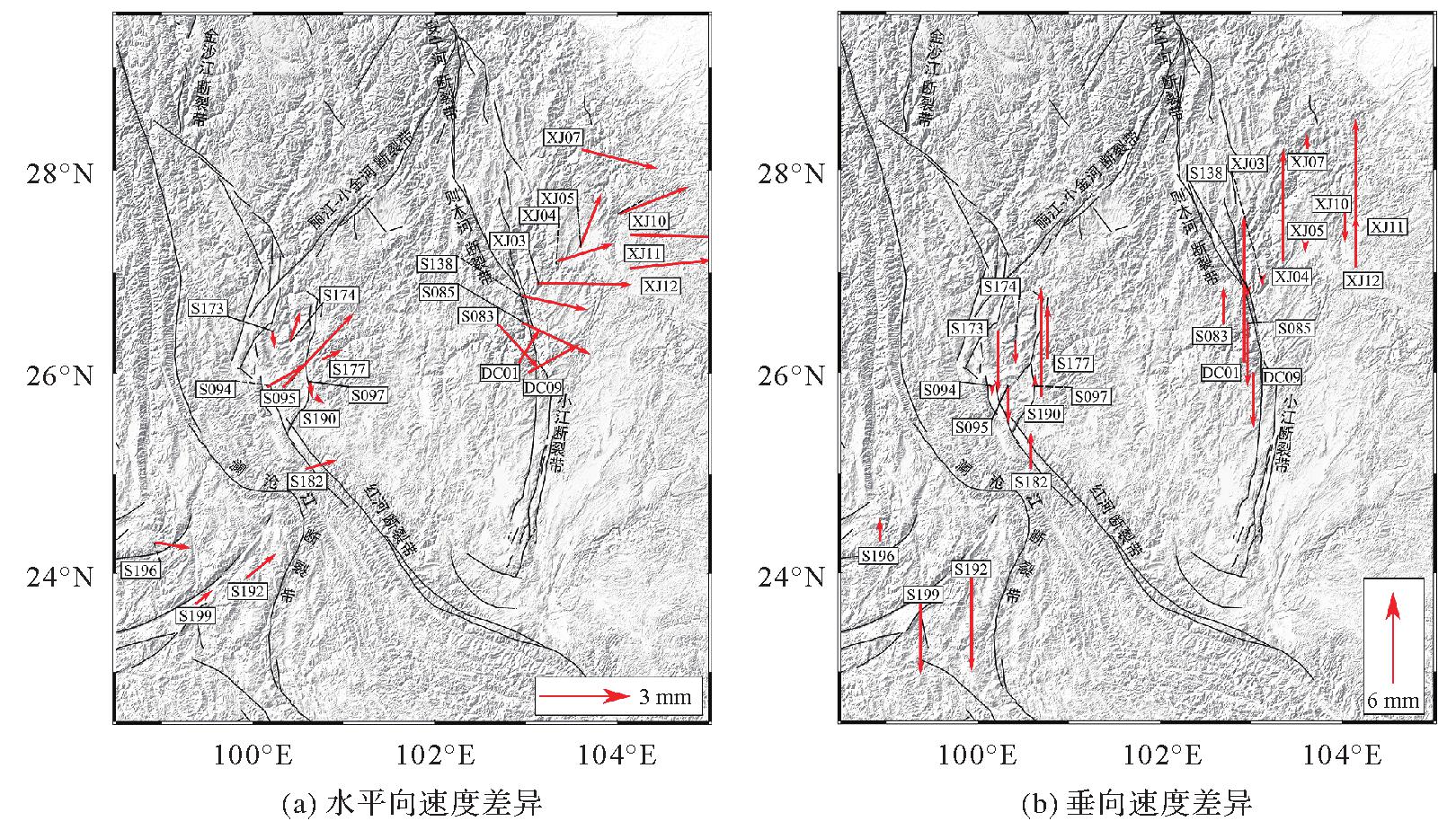
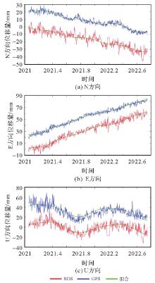
Fig. 8
The fitting of position time series of station S083"
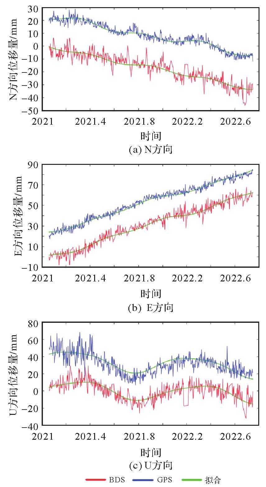
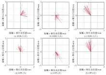
Fig. 9
The annual signals of BDS-3 and GPS observations"
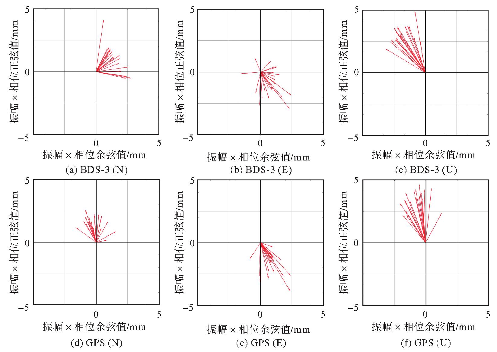

Fig. 10
The semi-annual signals derived from BDS-3 and GPS observations"
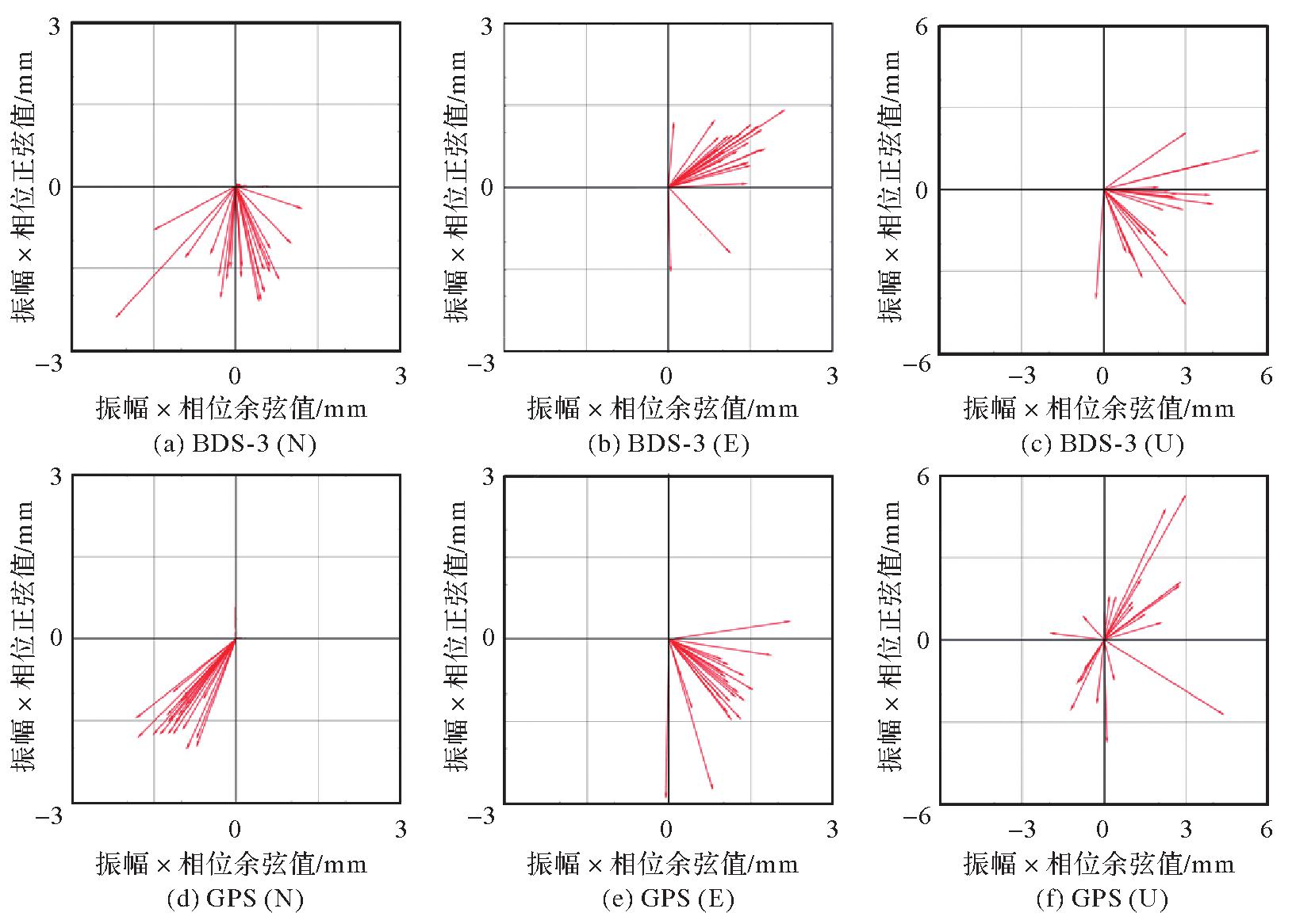
Fig. 11
Vertical annual signals derived from BDS-3 and GPS observations"

Tab. 3
The average horizontal velocities for stations in E, W, S and N regions(relative to ITRF14)"
| 区域 | 东 | 西 | 北 | 南 |
|---|---|---|---|---|
| 水平向速度均值 | 37.36 | 34.13 | 36.94 | 32.49 |
| [1] | 中国卫星导航系统管理办公室.北斗卫星导航系统介绍[EB/OL]. [2023-02-12].http://www.csno-tarc.cn/system/introduction. |
| China Satellite Navigation Office. BeiDou navigation satellite system introduction[EB/OL]. [2023-02-12]. http://www.csno-tarc.cn/system/introduction. | |
| [2] | 杨元喜, 许扬胤, 李金龙, 等. 北斗三号系统进展及性能预测:试验验证数据分析[J]. 中国科学:地球科学, 2018, 48(5):584-594. |
| YANG Yuanxi, XU Yangyin, LI Jinlong, et al. Progress and performance evaluation of BeiDou global navigation satellite system: data analysis based on BDS-3 demonstration system[J]. Scientia Sinica (Terrae), 2018, 48(5):584-594. | |
| [3] | 黄文德, 康娟, 张利云, 等. 北斗卫星导航定位原理与方法[M]. 北京: 科学出版社, 2019: 17. |
| HUANG Wende, KANG Juan, ZHANG Liyun, et al. Principle and method of BeiDou satellite navigation and positioning[M]. Beijing: Science Press, 2019: 17. | |
| [4] | 张双成, 王倩怡, 刘奇, 等. BDS精密相对定位精度的GAMIT分析[J]. 测绘科学, 2018, 43(12):92-97. |
| ZHANG Shuangcheng, WANG Qianyi, LIU Qi, et al. Analysis of precision relative positioning accuracy of BDS by GAMIT[J]. Science of Surveying and Mapping, 2018, 43(12):92-97. | |
| [5] | 王西龙, 许小龙, 赵齐乐. 北斗三号系统信号质量分析及轨道精度验证[J]. 武汉大学学报(信息科学版), 2023, 48(4):611-619. |
| WANG Xilong, XU Xiaolong, ZHAO Qile. Signal quality analysis and orbit accuracy verification of BDS-3[J]. Geomatics and Information Science of Wuhan University, 2023, 48(4):611-619. | |
| [6] | 程军龙, 王旺, 马立烨, 等. 北斗三号观测数据质量及定位精度初步评估[J]. 测绘通报, 2019(8):1-7. |
| CHENG Junlong, WANG Wang, MA Liye, et al. Preliminary analysis of observation quality and positioning precision for BDS-3 satellites[J]. Bulletin of Surveying and Mapping, 2019(8):1-7. | |
| [7] | 符宏伟. GNSS静态相对定位精度分析与比较[J]. 导航定位学报, 2021, 9(5):114-120. |
| FU Hongwei. Precision analysis and comparison of GNSS static relative positioning[J]. Journal of Navigation and Positioning, 2021, 9(5):114-120. | |
| [8] | SU Xiaoning, MENG Guojie, SUN Haili, et al. Positioning performance of BDS observation of the crustal movement observation network of China and its potential application on crustal deformation[J]. Sensors, 2018, 18(10):3353. |
| [9] | 中国卫星导航系统管理办公室测试评估研究中心.北斗系统状态:星座状态 [EB/OL].[2023-02-12].http://www.csno-tarc.cn/system/constellation. |
| Test and Assessment Research Center of China Satellite Navigation Office. BeiDou navigation system status: constellation status [EB/OL]. [2023-02-12]. http://www.csno-tarc.cn/system/constellation. | |
| [10] | HERRING T A, KING R W, MCCLUSKY S C. GLOBK reference manual: global Kalman filter VLBI and GPS analysis program, release 10.6 [EB/OL]. [2023-02-12].http://geoweb.mit.edu/gg/docs/GLOBK_Ref.pdf. |
| [11] | HERRING T A, KING R W, MCKLUSKY S C. GAMIT reference manual: GPS analysis at MIT, version 10.7 [EB/OL]. [2023-02-12].http://geoweb.mit.edu/gg/docs/GAMIT_Ref.pdf. |
| [12] | SAASTAMOINEN J. Contributions to the theory of atmospheric refraction[J]. Bulletin Géodésique (1946—1975), 1972, 105(1):279-298. |
| [13] | BOEHM J, NIELL A, TREGONING P, et al. Global mapping function (GMF): a new empirical mapping function based on numerical weather model data[J]. Geophysical Research Letters, 2006, 33(7):304-307. |
| [14] | LYARD F, LEFEVRE F, LETELLIER T, et al. Modelling the global ocean tides: modern insights from FES2004[J]. Ocean Dyna-mics, 2006, 56(5):394-415. |
| [15] | BOS M S, FERNANDES R M S, WILLIAMS S D P, et al. Fast error analysis of continuous GNSS observations with missing data[J]. Journal of Geodesy, 2013, 87(4):351-360. |
| [16] | NIKOLAIDIS R. Observation of geodetic and seismic deformation with the global positioning system [D]. San Diego: University of California, 2002. |
| [17] | ZHANG Jie, BOCK Y, JOHNSON H, et al. Southern California permanent GPS geodetic array: error analysis of daily position estimates and site velocities[J]. Journal of Geophical Research, 1997, 102(B8):18035-18055. |
| [18] | WILLIAMS S D P, BOCK Y, FANG Peng, et al. Error analysis of continuous GPS position time series[J]. Journal of Geophysical Research: Solid Earth, 2004, 109(B3):B03412. |
| [19] | 张小红, 丁乐乐. 北斗二代观测值质量分析及随机模型精化[J]. 武汉大学学报(信息科学版), 2013, 38(7):832-836. |
| ZHANG Xiaohong, DING Lele. Quality analysis of the second generation compass observables and stochastic model refining[J]. Geomatics and Information Science of Wuhan University, 2013, 38(7):832-836. | |
| [20] | 王阅兵, 甘卫军, 陈为涛, 等. 北斗导航系统精密单点定位在地壳运动监测中的应用分析[J]. 测绘学报, 2018, 47(1):48-56. DOI: 10.11947/j.AGCS.2018.20170147. |
| WANG Yuebing, GAN Weijun, CHEN Weitao, et al. The analysis of precise point positioning of BeiDou navigation satellite system application in crustal motion monitoring[J]. Acta Geodaetica et Cartographica Sinica, 2018, 47(1):48-56. DOI: 10.11947/j.AGCS.2018.20170147. | |
| [21] | 施闯, 魏娜, 李敏, 等. 利用北斗系统建立和维持国家大地坐标参考框架的方法研究[J]. 武汉大学学报(信息科学版), 2017, 42(11):1635-1643. |
| SHI Chuang, WEI Na, LI Min, et al. Approaches to realize and maintain national terrestrial reference frame based on BDS data[J]. Geomatics and Information Science of Wuhan University, 2017, 42(11):1635-1643. | |
| [22] | 李星星, 李婕, 袁勇强, 等. 北斗三号卫星经验型太阳光压模型分析与精化[J]. 测绘学报, 2022, 51(8):1680-1689. DOI: 10.11947/j.AGCS.2022.20210532. |
| LI Xingxing, LI Jie, YUAN Yongqiang, et al. Assessment and improvement of the empirical solar radiation pressure models for BDS-3 satellites[J]. Acta Geodaetica et Cartographica Sinica, 2022, 51(8):1680-1689. DOI: 10.11947/j.AGCS.2022.20210532. | |
| [23] | CHEN Qiuli, YANG Hui, CHEN Zhonggui, et al. Solar radiation pressure modeling and application of BDS satellites[J]. Journal of Geodesy and Geoinformation Science, 2020, 3(2):45-52. |
| [24] | 李星星, 张伟, 袁勇强, 等. GNSS卫星精密定轨综述:现状、挑战与机遇[J]. 测绘学报, 2022, 51(7):1271-1293. DOI: 10.11947/j.AGCS.2022.20220173. |
| LI Xingxing, ZHANG Wei, YUAN Yongqiang, et al. Review of GNSS precise orbit determination: status, challenges, and opportunities[J]. Acta Geodaetica et Cartographica Sinica, 2022, 51(7):1271-1293. DOI: 10.11947/j.AGCS.2022.20220173. | |
| [25] | 刘路, 郭金运, 周茂盛, 等. GNSS广播星历轨道和钟差精度分析[J]. 武汉大学学报(信息科学版), 2022, 47(7):1122-1132. |
| LIU Lu, GUO Jinyun, ZHOU Maosheng, et al. Accuracy analysis of GNSS broadcast ephemeris orbit and clock offset[J]. Geomatics and Information Science of Wuhan University, 2022, 47(7):1122-1132. | |
| [26] | 张小红, 李盼, 李星星, 等. 天线相位中心改正模型对PPP参数估计的影响[J]. 武汉大学学报(信息科学版), 2011, 36(12):1470-1473. |
| ZHANG Xiaohong, LI Pan, LI Xingxing, et al. Influcence of antenna phase center correction model on precise point positioning[J]. Geomatics and Information Science of Wuhan University, 2011, 36(12):1470-1473. | |
| [27] | 张胜凯, 左耀文, 鄂栋臣, 等. 天线相位中心改正模型对南极GPS基线解算的影响[J]. 测绘科学, 2018, 43(8):151-156. |
| ZHANG Shengkai, ZUO Yaowen, E Dongchen, et al. The impact of antenna phase center correction model on the GPS baseline solution in Antarctic[J]. Science of Surveying and Mapping, 2018, 43(8):151-156. | |
| [28] | 任琛, 王晨, 李振洪. 北斗三号卫星天线相位中心改正模型对精密定轨和定位的影响[J]. 大地测量与地球动力学, 2022, 42(12):1227-1232,1261. |
| REN Chen, WANG Chen, LI Zhenhong. Impact of satellites antenna phase center correction model on BDS-3 precise orbit determination and positioning[J]. Journal of Geodesy and Geodynamics, 2022, 42(12):1227-1232,1261. | |
| [29] | QU Ziyang, GUO Jing, ZHAO Qile. Phase center corrections for BDS IGSO and MEO satellites in IGb14 and IGSR3 frame[J]. Remote Sensing, 2021, 13(4):745. |
| [30] | 乔学军, 王琪, 杜瑞林. 川滇地区活动地块现今地壳形变特征[J]. 地球物理学报, 2004, 47(5):806-812. |
| QIAO Xuejun, WANG Qi, DU Ruilin. Characteristics of current crustal deformation of active blocks in the Sichuan-Yunnan region[J]. Chinese Journal of Geophysics, 2004, 47(5):806-812. |
| [1] | Jinwei BU, Shuhui LIU, Shunshuang XU, Tongsu XIANG, Qiulan WANG, Chaoying JI, Xiaoqing ZUO. Construction of an empirical model for estimating the global wave period of spaceborne GNSS-R [J]. Acta Geodaetica et Cartographica Sinica, 2026, 55(4): 684-697. |
| [2] | Tangting WU, Xinyu LUO, Liguo LU, Zhanke LIU, Nengfang CHAO. Assessment of water resource changes and drought characteristics in the Shaanxi, Gansu and Ningxia region based on GNSS and GRACE/GRACE-FO [J]. Acta Geodaetica et Cartographica Sinica, 2026, 55(3): 439-450. |
| [3] | Zhongmin MA, Shuangcheng ZHANG, Xin ZHOU, Qi LIU, Ning LIU, Hengli WANG. A flood monitoring method using FY-3 GNSS-R accounting for surface reflectivity uncertainty: a case study of the August 2 Guangdong rainstorm disaster [J]. Acta Geodaetica et Cartographica Sinica, 2026, 55(3): 451-464. |
| [4] | Qingyun YAN, Zixuan GUO, Yuanjin PAN, Yan JIA, Shuanggen JIN. Quantitative driving factors and zoning patterns of GNSS-R land surface reflectivity spatial heterogeneity [J]. Acta Geodaetica et Cartographica Sinica, 2026, 55(2): 315-327. |
| [5] | Qingzhi ZHAO, Duoduo JIANG, Yibin YAO, Zhi MA, Yongjie MA, Haojie LI, Ruirui XUE. An adaptive method for selecting the optimal GNSS satellite signal for water vapor tomography [J]. Acta Geodaetica et Cartographica Sinica, 2026, 55(1): 25-35. |
| [6] | Deying YU, Houpu LI, Yi LIU, Shuguang WU, Deyan LI, Mingchao LI, Wenkui LI, Shaofeng BIAN. A DBSCAN-based RAIM algorithm for multiple gross error identification [J]. Acta Geodaetica et Cartographica Sinica, 2026, 55(1): 59-72. |
| [7] | Dongliang CHENG, Lingqiu CHEN, Zhiyong HUANG, Shubo QIAO, Dandan WANG, Yaming YAN. Performance evaluation of COATS-based multi-mode and multi-frequency iGNSS-R altimetry [J]. Acta Geodaetica et Cartographica Sinica, 2026, 55(1): 73-89. |
| [8] | Yarong LUO, Wentao LU, Chi GUO, Jingnan LIU. Left-handed symmetry equivariant filtering model and algorithm for GNSS/INS integrated navigation [J]. Acta Geodaetica et Cartographica Sinica, 2025, 54(8): 1389-1403. |
| [9] | Yangyi CHEN, Kai ZHENG, Xiaohong ZHANG, Mingkui WU, Pengxu WANG, Wenju FU, Kezhong LIU. GPS/Galileo/BDS overlapping frequencies multipath error analysis and modeling [J]. Acta Geodaetica et Cartographica Sinica, 2025, 54(8): 1427-1438. |
| [10] | Jianzhang LI, Haowen YAN, Weifang YANG, Xiaoning SU. GNSS pseudo trigonometric leveling method [J]. Acta Geodaetica et Cartographica Sinica, 2025, 54(7): 1170-1177. |
| [11] | Qingzhi ZHAO, Lulu CHANG, Yibin YAO, Haojie LI. A method for constructing a hydrological drought index integrated with GNSS and meteorological data [J]. Acta Geodaetica et Cartographica Sinica, 2025, 54(7): 1192-1205. |
| [12] | Qianxin WANG, Chao HU, Tong CHENG. A method for satellite ultra-rapid orbit and clock offset estimation based on the prior information of the GNSS clock parameters [J]. Acta Geodaetica et Cartographica Sinica, 2025, 54(6): 982-994. |
| [13] | Yang SHEN, Guangyun LI, Mingjian CHEN, Linyang LI, Xingyu SHI, Wei CAI, Weifeng HAO. Assessment of GNSS ionosphere models based on FY-3 TEC in polar regions [J]. Acta Geodaetica et Cartographica Sinica, 2025, 54(6): 995-1008. |
| [14] | Shunqiang HU, Kejie CHEN, Xiaoxing HE, Hai ZHU, Tan WANG. The impact of environmental loading on nonlinear variations of 3D coordinate time series of GNSS stations in Sichuan and Yunnan region [J]. Acta Geodaetica et Cartographica Sinica, 2025, 54(5): 805-818. |
| [15] | Wentao YANG, Fei GUO, Xiaohong ZHANG, Zhiyu ZHANG, Yifan ZHU, Zheng LI, Ziheng WU. Soil moisture and freeze-thaw map using GNSS reflectometer and SMAP radiometer for Qinghai-Xizang Plateau [J]. Acta Geodaetica et Cartographica Sinica, 2025, 54(4): 725-735. |
| Viewed | ||||||
|
Full text |
|
|||||
|
Abstract |
|
|||||