

Acta Geodaetica et Cartographica Sinica ›› 2025, Vol. 54 ›› Issue (4): 603-620.doi: 10.11947/j.AGCS.2025.20230137
• Review • Previous Articles Next Articles
Xinchang ZHANG1,2,3( ), Ji QI1,3(), Chao TAO4, Siyang FU5, Mingning GUO4, Yongjian RUAN1,3
Received:2024-03-29
Online:2025-05-30
Published:2025-05-30
Contact:
Ji QI
E-mail:zhangxc@gzhu.edu.cn;jameschi95@foxmail.com
About author:ZHANG Xinchang (1957—), male, PhD, professor, majors in spatial data integration and adaptive updating technologies, digital city (smart city) theories and methods, as well as deep learning and the classification and extraction of natural resource elements. E-mail: zhangxc@gzhu.edu.cn
Supported by:CLC Number:
Xinchang ZHANG, Ji QI, Chao TAO, Siyang FU, Mingning GUO, Yongjian RUAN. A survey on cloud removal in optical remote sensing images: progress, challenges, and future works[J]. Acta Geodaetica et Cartographica Sinica, 2025, 54(4): 603-620.
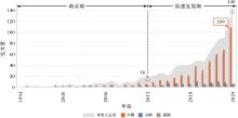
Fig. 1
Literature published in the field of cloud removal in optical remote sensing image"
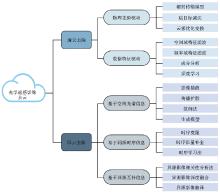
Fig. 2
Summary of cloud removal in optical remote sensing image"
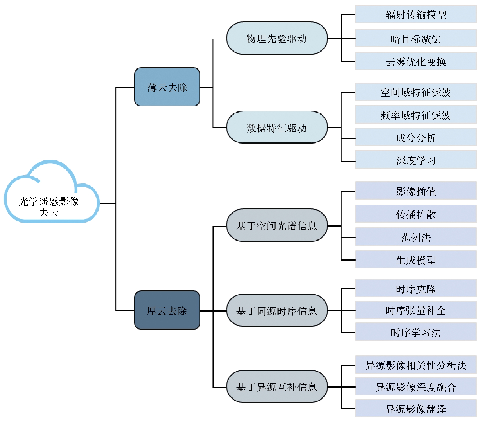
Tab. 1
Overview of studies on thin cloud removal in optical remote sensing images and representative approaches"
| 大类 | 子类 | 代表性工作 | 说明 |
|---|---|---|---|
| 物理先验驱动 | 辐射传输模型(RTM) | 传统RTM[ | 对整个大气辐射传输过程建模以去除大气或云雾干扰 |
| 物理视角简化RTM[ | 对云雾干扰下的辐射传输过程进行建模 | ||
| 统计视角简化RTM[ | 用数据统计规律或经验公式近似替代传统RTM的部分物理建模过程 | ||
| 暗目标减法(DOS) | 全局DOS[ | 对整个影像搜索暗目标并作为先验引导云雾去除 | |
| 局部DOS[ | 对影像的不同局部区域分别提取暗目标 | ||
| 暗通道先验法[ | 从影像中提取像素的暗通道作为先验信息 | ||
| 云雾优化变换(HOT) | 传统HOT方法[ | 手动选取晴空线来计算HOT图并引导云雾去除 | |
| 自动化HOT[ | 自动选取影像中的代表性无云区域以定义晴空线 | ||
| 掩膜HOT[ | 将部分明亮地物进行掩膜以消除虚假响应 | ||
| 迭代HOT[ | 通过迭代挖掘额外参考影像的信息以提升HOT图准确性 | ||
| AHOT[ | 通过非线性变换得到HOT响应图 | ||
| HOT&云轨迹[ | 建模过程考虑了云雾干扰的乘性影响 | ||
| 大类 | 子类 | 代表性工作 | 说明 |
| 数据特征驱动 | 空间域特征滤波(SDFF) | 中值滤波法[ | 将薄云视为稀疏椒盐噪声,并用中值滤波去云 |
| 均值滤波法[ | 将薄云视为低频噪声,用均值滤波提取图像的低频云雾信息进行去云 | ||
| 拉普拉斯滤波法[ | 将薄云干扰视为高斯模糊噪声,并通过增强影像高频信息来实现去云 | ||
| 频率域特征滤波(FDFF) | 同态滤波法(HF)[ | 假设云雾与地物乘性耦合,通过对数变换将乘性噪声转化为加性噪声,并在频域应用高通滤波器去云 | |
| 小波变换法(WA)[ | 通过在不同尺度上分别抑制低频云雾信息并增强高频地表信息来实现去云 | ||
| 成分分析(CA) | 独立成分分析法(ICA)[ | 假设云雾和地表信息为线性混合的非高斯独立信号,利用独立成分分析算法分离两者 | |
| 主成分变换法(PCT)[ | 通过最大化信噪比并调整噪声水平来分离云雾与地表信息 | ||
| 深度学习(DL) | 数据集构建 | 以仿真模拟[ | |
| 网络架构设计 | 包括编码器架构[ | ||
| 损失函数设计 | 包括监督损失函数[ |
Tab. 2
Overview of studies on think cloud removal in optical remote sensing images and representative approaches"
| 大类 | 子类 | 代表性工作 | 说明 |
|---|---|---|---|
| 基于空间光谱信息的方法 | 影像插值 | 克里金插值法[ | 基于相邻像素光谱相似性,通过插值重建被厚云遮挡的区域 |
| 最大后验概率插值[ | 利用影像的空间自相关性,结合光谱、纹理和边缘信息重建缺失区域 | ||
| 传播扩散 | 基于偏微分方程的扩散模型[ | 基于偏微分方程构建扩散模型,通过空间光谱信息的传播扩散来修复缺失区域 | |
| 基于深度学习的扩散模型[ | 基于数据驱动的扩散模型,利用统计先验引导信息传播来修复缺失区域 | ||
| 范例法 | 像素级范例法[ | 通过检索并复制与缺失区域相似的像素来完成影像修复 | |
| 补丁级范例法[ | 通过检索并替换缺失区域的相似区域来修复影像 | ||
| 生成模型 | 生成对抗网络[ | 学习语义信息与视觉表现之间的映射关系来实现去云利用统计先验引导信息传播实现去云修复 | |
| 基于同源时序信息的方法 | 时序克隆 | 直接时序克隆[ | 假设时序差异小,直接用参考影像填补当前影像缺失 |
| 间接时序克隆[ | 通过辐射校正提升两者视觉一致性,再用参考影像的信息来修复当前影像 | ||
| 时空融合克隆[ | 结合时序影像空间和时序信息,联合插值和信息克隆方法修复影像缺失区域 | ||
| 时序张量补全 | 基于时序连续性的矩阵补全[ | 利用时序影像的低秩张量表示,从残缺数据提取本质特征以重建完整影像 | |
| 时序学习法 | 基于传统机器学习的方法[ | 基于低层次视觉特征构建稀疏特征映射,恢复完整影像 | |
| 基于深度学习的方法[ | 基于深度学习模型建立残缺时序数据与无云影像的复杂映射关系进行去云 | ||
| 基于异源互补信息的方法 | 异源影像相关性分析法 | 异源光学影像相关性分析法[ | 分析并利用异源光学参考影像的光谱相关性,从参考影像中提取先验信息进行去云 |
| 异源光学-SAR影像相关性分析法[ | 利用光学和SAR影像的非显式相关性来指导基于范例法的图像修复 | ||
| 异源影像深度融合 | 基于物理或统计特性的融合方法[ | 分析异源遥感影像在物理或统计特性上的互补性,并通过融合异源影像来生成无云影像 | |
| 基于深度学习的融合方法[ | 通过深度学习建立异源遥感影像互补性,并通过融合异源影像得到无云影像 | ||
| 异源影像翻译 | SAR-光学转换[ | 通过深度学习建立SAR与光学影像的映射关系,生成无云光学影像 |
| [1] |
李德仁, 张良培, 夏桂松. 遥感大数据自动分析与数据挖掘[J]. 测绘学报, 2014, 43(12): 1211-1216. DOI:.
doi: 10.13485/j.cnki.11-2089.2014.0187 |
|
LI Deren, ZHANG Liangpei, XIA Guisong. Automatic analysis and mining of remote sensing big data[J]. Acta Geodaetica et Cartographica Sinica, 2014, 43(12): 1211-1216. DOI:.
doi: 10.13485/j.cnki.11-2089.2014.0187 |
|
| [2] | 廖小罕. 中国对地观测20年科技进步和发展[J]. 遥感学报, 2021, 25(1): 267-275. |
| LIAO Xiaohan. Scientific and technological progress and development prospect of the Earth observation in China in the past 20 years[J]. National Remote Sensing Bulletin, 2021, 25(1): 267-275. | |
| [3] | ROSSOW W, GOLEA V, WALKER A, et al. International satellite cloud climatology project (ISCCP) climate data record, H-series[Z]. [S.l.]: NOAA National Centers for Environmental Information, 2017. |
| [4] | JU Junchang, ROY D P. The availability of cloud-free Landsat ETM+ data over the conterminous United States and globally[J]. Remote Sensing of Environment, 2008, 112(3): 1196-1211. |
| [5] | 姜侯, 吕宁. 单幅光学遥感影像去霾算法及评价综述[J]. 中国图象图形学报, 2019, 24(9): 1416-1433. |
| JIANG Hou, LÜ Ning. Overview of single image-based haze removal method for visible remote sensing images[J]. Journal of Image and Graphics, 2019, 24(9): 1416-1433. | |
| [6] | SHEN Huanfeng, JIANG Menghui, LI Jie, et al. Coupling model-and data-driven methods for remote sensing image restoration and fusion: improving physical interpretability[J]. IEEE Geoscience and Remote Sensing Magazine, 2022, 10(2): 231-249. |
| [7] | 李德仁, 童庆禧, 李荣兴, 等. 高分辨率对地观测的若干前沿科学问题[J]. 中国科学:地球科学, 2012, 42(6): 805-813. |
| LI Deren, TONG Qingxi, LI Rongxing, et al. Current issues in high-resolution Earth observation technology[J]. Science China Earth Sciences, 2012, 55: 1043-1051. | |
| [8] | KAUR H, SOHI N. Cloud detection: a systematic review and evaluation[C]//Proceedings of 2016 ICCCCS. Singapore: Springer, 2018: 217-229. |
| [9] | LI Liyuan, LI Xiaoyan, JIANG Linyi, et al. A review on deep learning techniques for cloud detection methodologies and challenges[J]. Signal, Image and Video Processing, 2021, 15(7): 1527-1535. |
| [10] | GUPTA R, NANDA S J. Cloud detection in satellite images with classical and deep neural network approach: a review[J]. Multimedia Tools and Applications, 2022, 81(22): 31847-31880. |
| [11] | LI Zhiwei, SHEN Huanfeng, WENG Qihao, et al. Cloud and cloud shadow detection for optical satellite imagery: features, algorithms, validation, and prospects[J]. ISPRS Journal of Photogrammetry and Remote Sensing, 2022, 188: 89-108. |
| [12] | 陈津乐, 张锦水, 段雅鸣, 等. 中分辨率遥感影像云检测与厚云去除研究综述[J]. 遥感技术与应用, 2023, 38(1): 143-155. |
| CHEN Jinle, ZHANG Jinshui, DUAN Yaming, et al. A review of cloud detection and thick cloud removal in medium resolution remote sensing images[J]. Remote Sensing Technology and Application, 2023, 38(1): 143-155. | |
| [13] | 刘子力, 杨家俊, 王文静, 等. 遥感图像云检测方法综述[J]. 中国空间科学技术, 2023, 43(1): 1-17. |
| LIU Zili, YANG Jiajun, WANG Wenjing, et al. Cloud detection methods for remote sensing images: a survey[J]. Chinese Space Science and Technology, 2023, 43(1): 1-17. | |
| [14] | 徐萌, 王思涵, 郭仁忠, 等. 遥感影像云检测和去除方法综述[J]. 计算机研究与发展, 2023, 61(6): 1585-1607. |
| XU Meng, WANG Sihan, GUO Renzhong, et al. A review of cloud detection and removal methods for remote sensing images[J]. Journal of Computer Research and Development, 2023, 61(6): 1585-1607. | |
| [15] | VERMOTE E F, TANRE D, DEUZE J L, et al. Second simulation of the satellite signal in the solar spectrum, 6S: an overview[J]. IEEE Transactions on Geoscience and Remote Sensing, 1997, 35(3): 675-686. |
| [16] | LIANG S, FANG H, CHEN M. Atmospheric correction of Landsat ETM+ land surface imagery. I. methods[J]. IEEE Transactions on Geoscience and Remote Sensing, 2001, 39(11): 2490-2498. |
| [17] | GAO Bocai, YANG Ping, HAN Wei, et al. An algorithm using visible and 1.38 μm channels to retrieve cirrus cloud reflectances from aircraft and satellite data[J]. IEEE Transactions on Geoscience and Remote Sensing, 2002, 40(8): 1659-1668. |
| [18] | XU Meng, PICKERING M, PLAZA A J, et al. Thin cloud removal based on signal transmission principles and spectral mixture analysis[J]. IEEE Transactions on Geoscience and Remote Sensing, 2016, 54(3): 1659-1669. |
| [19] | LI Enguang, ZHANG Zhaoyang, TAN Yunhui, et al. A novel cloud detection algorithm based on simplified radiative transfer model for aerosol retrievals: preliminary result on Himawari-8 over eastern China[J]. IEEE Transactions on Geoscience and Remote Sensing, 2021, 59(3): 2550-2561. |
| [20] | LÜ Haitao, WANG Yong, SHEN Yang. An empirical and radiative transfer model based algorithm to remove thin clouds in visible bands[J]. Remote Sensing of Environment, 2016, 179: 183-195. |
| [21] | GAO Bocai, LI Rongrong. Removal of thin cirrus scattering effects in Landsat 8 OLI images using the cirrus detecting channel[J]. Remote Sensing, 2017, 9(8): 834. |
| [22] | ZHANG Chi, YI Peng, LIU Yang, et al. Thin cloud correction method for visible remote sensing images using a spectral transformation scheme[J]. GIScience & Remote Sensing, 2023, 60(1): 2196133. |
| [23] | CHAVEZ P S. An improved dark-object subtraction technique for atmospheric scattering correction of multispectral data[J]. Remote Sensing of Environment, 1988, 24(3): 459-479. |
| [24] | KAUFMAN Y J, SENDRA C. Algorithm for automatic atmospheric corrections to visible and near-IR satellite imagery[J]. International Journal of Remote Sensing, 1988, 9(8): 1357-1381. |
| [25] | DING Huimei, SHI Junsheng, WANG Yuanfangzhou, et al. An improved dark-object subtraction technique for atmospheric correction of Landsat 8[C]//Proceedings of 2015 International Symposium on Multispectral Image Processing and Pattern Recognition. Enshi: SPIE, 2015. |
| [26] | MAKARAU A, RICHTER R, MULLER R, et al. Haze detection and removal in remotely sensed multispectral imagery[J]. IEEE Transactions on Geoscience and Remote Sensing, 2014, 52(9): 5895-5905. |
| [27] | XU Haoran, GUO Jianming, LIU Qing, et al. Fast image dehazing using improved dark channel prior[C]//Proceedings of 2012 IEEE International Conference on Information Science and Technology. Wuhan: IEEE, 2012: 663-667. |
| [28] | LONG Jiao, SHI Zhenwei, TANG Wei, et al. Single remote sensing image dehazing[J]. IEEE Geoscience and Remote Sensing Letters, 2014, 11(1): 59-63. |
| [29] | HE Kaiming, SUN Jian, TANG Xiaoou. Single image haze removal using dark channel prior[J]. IEEE Transactions on Pattern Analysis and Machine Intelligence, 2011, 33(12): 2341-2353. |
| [30] | LI Jiayuan, HU Qingwu, AI Mingyao. Haze and thin cloud removal via sphere model improved dark channel prior[J]. IEEE Geoscience and Remote Sensing Letters, 2019, 16(3): 472-476. |
| [31] | ZHANG Y, GUINDON B, CIHLAR J. An image transform to characterize and compensate for spatial variations in thin cloud contamination of Landsat images[J]. Remote Sensing of Environment, 2002, 82(2/3): 173-187. |
| [32] | LU D. Detection and substitution of clouds/hazes and their cast shadows on IKONOS images[J]. International Journal of Remote Sensing, 2007, 28(18): 4027-4035. |
| [33] | ZHU Zhe, WOODCOCK C E. Object-based cloud and cloud shadow detection in Landsat imagery[J]. Remote Sensing of Environment, 2012, 118: 83-94. |
| [34] | WU Wei, LUO Jiancheng, HU Xiaodong, et al. A thin-cloud mask method for remote sensing images based on sparse dark pixel region detection[J]. Remote Sensing, 2018, 10(4): 617. |
| [35] | HE Xingyuan, HU Jianbo, CHEN Wei, et al. Haze removal based on advanced haze-optimized transformation (AHOT) for multispectral imagery[J]. International Journal of Remote Sensing, 2010, 31(20): 5331-5348. |
| [36] | CHEN Shuli, CHEN Xuehong, CHEN Jin, et al. An iterative haze optimized transformation for automatic cloud/haze detection of Landsat imagery[J]. IEEE Transactions on Geoscience and Remote Sensing, 2016, 54(5): 2682-2694. |
| [37] | CHEN Shuli, CHEN Xuehong, CHEN Xiang, et al. A novel cloud removal method based on IHOT and the cloud trajectories for Landsat imagery[J]. Remote Sensing, 2018, 10(7): 1040. |
| [38] | 沈文水, 周新志. 基于同态滤波的遥感薄云去除算法[J]. 强激光与粒子束, 2010, 22(1): 45-48. |
| SHEN Wenshui, ZHOU Xinzhi. Algorithm for removing thin cloud from remote sensing digital images based on homomorphic filtering[J]. High Power Laser and Particle Beams, 2010, 22(1): 45-48. | |
| [39] | YU Guang, SUN Wen bang, LIU Gang, et al. A thin cloud removal method for optical image based on improved homomorphism filtering[J]. Applied Mechanics and Materials, 2014, 618: 519-522. |
| [40] | 谢华美, 李荣艳, 田艳琴, 等. 基于大数据量遥感图像的薄云去除[J]. 北京师范大学学报(自然科学版), 2006, 42(1): 42-46. |
| XIE Huamei, LI Rongyan, TIAN Yanqin, et al. The removing clouds method based on large remote sensing image[J]. Journal of Beijing Normal University (Natural Science), 2006, 42(1): 42-46. | |
| [41] | MITCHELL O R, DELP E J, CHEN P L. Filtering to remove cloud cover in satellite imagery[J]. IEEE Transactions on Geoscience Electronics, 1977, 15(3): 137-141. |
| [42] | LIU Z K, HUNT B R. A new approach to removing cloud cover from satellite imagery[J]. Computer Vision, Graphics, and Image Processing, 1984, 25(2): 252-256. |
| [43] | DU Yong, GUINDON B, CIHLAR J. Haze detection and removal in high resolution satellite image with wavelet analysis[J]. IEEE Transactions on Geoscience and Remote Sensing, 2002, 40(1): 210-217. |
| [44] | 陈奋, 闫冬梅, 赵忠明. 基于无抽样小波的遥感影像薄云检测与去除[J]. 武汉大学学报(信息科学版), 2007, 32(1): 71-74. |
| CHEN Fen, YAN Dongmei, ZHAO Zhongming. Haze detection and removal in remote sensing images based on undecimated wavelet transform[J]. Geomatics and Information Science of Wuhan University, 2007, 32(1): 71-74. | |
| [45] | 朱锡芳, 吴峰, 庄燕滨. 基于Mallat算法遥感图像去云雾处理的改进方法[J]. 遥感学报, 2007, 11(2): 241-246. |
| ZHU Xifang, WU Feng, ZHUANG Yanbin. An improved approach to remove cloud and mist from remote sensing digital images based on Mallat algorithm[J]. Journal of Remote Sensing, 2007, 11(2): 241-246. | |
| [46] | HU Gensheng, LI Xiaoyi, LIANG Dong. Thin cloud removal from remote sensing images using multidirectional dual tree complex wavelet transform and transfer least square support vector regression[J]. Journal of Applied Remote Sensing, 2015, 9(1): 095053. |
| [47] | SHEN Yang, WANG Yong, LÜ Haitao, et al. Removal of thin clouds in Landsat-8 OLI data with independent component analysis[J]. Remote Sensing, 2015, 7(9): 11481-11500. |
| [48] | LÜ Haitao, WANG Yong, GAO Yue. Using independent component analysis and estimated thin-cloud reflectance to remove cloud effect on Landsat-8 OLI band data[C]//Proceedings of 2018 IEEE International Geoscience and Remote Sensing Symposium. Valencia: IEEE, 2018: 915-918. |
| [49] | XU Meng, JIA Xiuping, PICKERING M, et al. Thin cloud removal from optical remote sensing images using the noise-adjusted principal components transform[J]. ISPRS Journal of Photogrammetry and Remote Sensing, 2019, 149: 215-225. |
| [50] | ENOMOTO K, SAKURADA K, WANG Weimin, et al. Filmy cloud removal on satellite imagery with multispectral conditional generative adversarial nets[C]//Proceedings of 2017 IEEE Conference on Computer Vision and Pattern Recognition Workshops. Honolulu: IEEE, 2017: 1533-1541. |
| [51] | QIN Manjun, XIE Fengying, LI Wei, et al. Dehazing for multispectral remote sensing images based on a convolutional neural network with the residual architecture[J]. IEEE Journal of Selected Topics in Applied Earth Observations and Remote Sensing, 2018, 11(5): 1645-1655. |
| [52] | JIANG Bo, WANG Jinshuai, WU Yuwei, et al. A dehazing method for remote sensing image under nonuniform hazy weather based on deep learning network[J]. IEEE Transactions on Geoscience and Remote Sensing, 2023, 61: 1-17. |
| [53] | LIN Daoyu, XU Guangluan, WANG Xiaoke, et al. A remote sensing image dataset for cloud removal[EB/OL]. [2023-04-03]. https://arxiv.org/abs/1901.00600v1. |
| [54] | CAI Bolun, XU Xiangmin, JIA Kui, et al. DehazeNet: an end-to-end system for single image haze removal[J]. IEEE Transactions on Image Processing, 2016, 25(11): 5187-5198. |
| [55] | DING Haidong, XIE Fengying, ZI Yue, et al. Feedback network for compact thin cloud removal[J]. IEEE Geoscience and Remote Sensing Letters, 2023, 20: 3256416. |
| [56] | LI Wenbo, LI Ying, CHEN Di, et al. Thin cloud removal with residual symmetrical concatenation network[J]. ISPRS Journal of Photogrammetry and Remote Sensing, 2019, 153: 137-150. |
| [57] | ZHENG Jiahao, LIU Xiaoyang, WANG Xiaodong. Single image cloud removal using U-Net and generative adversarial networks[J]. IEEE Transactions on Geoscience and Remote Sensing, 2021, 59(8): 6371-6385. |
| [58] | LI Jun, ZHANG Yuejie, SHENG Qinghong, et al. Thin cloud removal fusing full spectral and spatial features for Sentinel-2 imagery[J]. IEEE Journal of Selected Topics in Applied Earth Observations and Remote Sensing, 2022, 15: 8759-8775. |
| [59] | LI Xiaoling, HUA Zhen, LI Jinjiang. Two-stage single image dehazing network using swin-transformer[J]. IET Image Processing, 2022, 16(9): 2518-2534. |
| [60] | YANG Zhe, LI Xiaoling, LI Jinjiang. Transformer-based progressive residual network for single image dehazing[J]. Frontiers in Neurorobotics, 2022, 16: 1084543. |
| [61] | MA Xianping, HUANG Yiming, ZHANG Xiaokang, et al. Cloud-EGAN: rethinking CycleGAN from a feature enhancement perspective for cloud removal by combining CNN and Transformer[J]. IEEE Journal of Selected Topics in Applied Earth Observations and Remote Sensing, 2023, 16: 4999-5012. |
| [62] | ZHOU Jianjun, LUO Xiaobo, RONG Wentao, et al. Cloud removal for optical remote sensing imagery using distortion coding network combined with compound loss functions[J]. Remote Sensing, 2022, 14(14): 3452. |
| [63] | ZONG Ping, LI Jinjiang, HUA Zhen. Lightweight multi-scale attentional network for single image dehazing[C]//Proceedings of 2022 International Conference on Image Processing, Computer Vision and Machine Learning. Xi'an: IEEE, 2022: 401-405. |
| [64] | SINGH P, KOMODAKIS N. Cloud-Gan: cloud removal for Sentinel-2 imagery using a cyclic consistent generative adversarial networks[C]//Proceedings of 2018 IEEE International Geoscience and Remote Sensing Symposium. Valencia: IEEE, 2018: 1772-1775. |
| [65] | WEI Jianchong, CAO Yan, YANG Kunping, et al. Self-supervised remote sensing image dehazing network based on zero-shot learning[J]. Remote Sensing, 2023, 15(11): 2732. |
| [66] | CHAVEZ P S. Image-based atmospheric corrections: revisited and improved[J]. Photogrammetric engineering and remote Sensing, 1996, 62(9): 1025-1035. |
| [67] | KAUFMAN Y J, REMER L A. Detection of forests using mid-IR reflectance: an application for aerosol studies[J]. IEEE Transactions on Geoscience and Remote Sensing, 1994, 32(3): 672-683. |
| [68] | 姜侯, 吕宁, 姚凌. 改进HOT法的Landsat 8 OLI遥感影像雾霾及薄云去除[J]. 遥感学报, 2016, 20(4): 620-631. |
| JIANG Hou, LÜ Ning, YAO Ling. HOT-transform based method to remove haze or thin cloud for Landsat 8 OLI satellite data[J]. Journal of Remote Sensing, 2016, 20(4): 620-631. | |
| [69] | CAI Wenting, LIU Yongxue, LI Manchun, et al. A self-adaptive homomorphic filter method for removing thin cloud[C]//Proceedings of 2011 International Conference on Geoinformatics. Shanghai: IEEE, 2011: 1-4. |
| [70] | LI Jun, WU Zhaocong, HU Zhongwen, et al. Deep learning based thin cloud removal fusing vegetation red edge and short wave infrared spectral information for Sentinel-2A imagery[J]. Remote Sensing, 2021, 13(1): 157. |
| [71] | ZHANG Chuanrong, LI Weidong, TRAVIS D. Gaps-fill of SLC-off Landsat ETM+ satellite image using a geostatistical approach[J]. International Journal of Remote Sensing, 2007, 28(22): 5103-5122. |
| [72] | ZHANG Chuanrong, LI Weidong, TRAVIS D J. Restoration of clouded pixels in multispectral remotely sensed imagery with cokriging[J]. International Journal of Remote Sensing, 2009, 30(9): 2173-2195. |
| [73] | SHEN Huanfeng, ZHANG Liangpei. A MAP-based algorithm for destriping and inpainting of remotely sensed images[J]. IEEE Transactions on Geoscience and Remote Sensing, 2009, 47(5): 1492-1502. |
| [74] | TELEA A. An image inpainting technique based on the fast marching method[J]. Journal of Graphics Tools, 2004, 9(1): 23-34. |
| [75] | MAALOUF A, CARRE P, AUGEREAU B, et al. A bandelet-based inpainting technique for clouds removal from remotely sensed images[J]. IEEE Transactions on Geoscience and Remote Sensing, 2009, 47(7): 2363-2371. |
| [76] | JING Ran, DUAN Fuzhou, LU Fengxian, et al. Denoising diffusion probabilistic feature-based network for cloud removal in Sentinel-2 imagery[J]. Remote Sensing, 2023, 15(9): 2217. |
| [77] | KHANNA S, LIU P, ZHOU Linqi, et al. DiffusionSat: a generative foundation model for satellite imagery[EB/OL]. [2023-04-03]. https://arxiv.org/pdf/2312.03606. |
| [78] | 胡浩, 李佳田, 阿晓荟, 等. 利用隐扩散模型的光学遥感影像去云方法[J]. 光学学报, 2024, 44(12): 1228009. |
| HU Hao, LI Jiatian, A Xiaohui, et al. Method for cloud removal from optical remote-sensing image based onlatent diffusion model[J]. Acta Optica Sinica, 2024, 44(12): 1228009. | |
| [79] | ZOU Xuechao, LI Kai, XING Junliang, et al. DiffCR: a fast conditional diffusion framework for cloud removal from optical satellite images[J]. IEEE Transactions on Geoscience and Remote Sensing, 2024, 62: 1-14. |
| [80] | EFROS A A, LEUNG T K. Texture synthesis by non-parametric sampling[C]//Proceedings of 1999 IEEE International Conference on Computer Vision. Kerkyra: IEEE, 1999: 1033-1038. |
| [81] | BARNES C, SHECHTMAN E, FINKELSTEIN A, et al. PatchMatch: a randomized correspondence algorithm for structural image editing[J]. ACM Transactions on Graphics, 2009, 28(3): 1-11. |
| [82] | LORENZI L, MELGANI F, MERCIER G. Inpainting strategies for reconstruction of missing data in VHR images[J]. IEEE Geoscience and Remote Sensing Letters, 2011, 8(5): 914-918. |
| [83] | ZHENG Wenjie, ZHAO Xile, ZHENG Yubang, et al. Nonlocal patch-based fully connected tensor network decomposition for multispectral image inpainting[J]. IEEE Geoscience and Remote Sensing Letters, 2022, 19: 3124804. |
| [84] |
郑凯, 李建胜, 王俊强, 等. DCLS-GAN:利用生成对抗网络的天绘一号卫星高原地区影像去云方法[J]. 测绘学报, 2021, 50(2): 248-259. DOI:.
doi: 10.11947/j.AGCS.2021.20200020 |
|
ZHENG Kai, LI Jiansheng, WANG Junqiang, et al. DCLS-GAN: cloud removal method for plateau area of TH-1 satellite image[J]. Acta Geodaetica et Cartographica Sinica, 2021, 50(2): 248-259. DOI:.
doi: 10.11947/j.AGCS.2021.20200020 |
|
| [85] | SHAO Mingwen, WANG Chao, WU Tianjun, et al. Context-based multiscale unified network for missing data reconstruction in remote sensing images[J]. IEEE Geoscience and Remote Sensing Letters, 2022, 19: 3021116. |
| [86] | TAO Chao, FU Siyang, QI Ji, et al. Thick cloud removal in optical remote sensing images using a texture complexity guided self-paced learning method[J]. IEEE Transactions on Geoscience and Remote Sensing, 2022, 60: 1-12. |
| [87] | HELMER E H, RUEFENACHT B. Cloud-free satellite image mosaics with regression trees and histogram matching[J]. Photogrammetric Engineering & Remote Sensing, 2005, 71(9): 1079-1089. |
| [88] | TSENG D C, TSENG H T, CHIEN C L. Automatic cloud removal from multi-temporal SPOT images[J]. Applied Mathematics and Computation, 2008, 205(2): 584-600. |
| [89] | WANG B, ONO A, MURAMATSU K, et al. Automated detection and removal of clouds and their shadows from Landsat TM images[J]. IEICE transactions on information and Systems, 1999, E82-D(2): 453-460. |
| [90] | LIN C H, TSAI P H, LAI K H, et al. Cloud removal from multitemporal satellite images using information cloning[J]. IEEE Transactions on Geoscience and Remote Sensing, 2013, 51(1): 232-241. |
| [91] | LIN C H, LAI K H, CHEN Z B, et al. Patch-based information reconstruction of cloud-contaminated multitemporal images[J]. IEEE Transactions on Geoscience and Remote Sensing, 2014, 52(1): 163-174. |
| [92] | ZHU Shaocong, LI Zhiwei, SHEN Huanfeng, et al. A fast two-step algorithm for large-area thick cloud removal in high-resolution images[J]. Remote Sensing Letters, 2023, 14(1): 1-9. |
| [93] | CHEN Jin, ZHU Xiaolin, VOGELMANN J E, et al. A simple and effective method for filling gaps in Landsat ETM+ SLC-off images[J]. Remote Sensing of Environment, 2011, 115(4): 1053-1064. |
| [94] | POGGIO L, GIMONA A, BROWN I. Spatio-temporal MODIS EVI gap filling under cloud cover: an example in Scotland[J]. ISPRS Journal of Photogrammetry and Remote Sensing, 2012, 72: 56-72. |
| [95] | ZHU Xiaolin, GAO Feng, LIU Desheng, et al. A modified neighborhood similar pixel interpolator approach for removing thick clouds in landsat images[J]. IEEE Geoscience and Remote Sensing Letters, 2012, 9(3): 521-525. |
| [96] | CHENG Qing, SHEN Huanfeng, ZHANG Liangpei, et al. Cloud removal for remotely sensed images by similar pixel replacement guided with a spatio-temporal MRF model[J]. ISPRS Journal of Photogrammetry and Remote Sensing, 2014, 92: 54-68. |
| [97] | CHEN Bin, HUANG Bo, CHEN Lifan, et al. Spatially and temporally weighted regression: a novel method to produce continuous cloud-free landsat imagery[J]. IEEE Transactions on Geoscience and Remote Sensing, 2017, 55(1): 27-37. |
| [98] | SHEN Huanfeng, WU Jingan, CHENG Qing, et al. A spatiotemporal fusion based cloud removal method for remote sensing images with land cover changes[J]. IEEE Journal of Selected Topics in Applied Earth Observations and Remote Sensing, 2019, 12(3): 862-874. |
| [99] | WANG Jialei, OLSEN P A, CONN A R, et al. Removing clouds and recovering ground observations in satellite image sequences via temporally contiguous robust matrix completion[C]//Proceedings of 2016 IEEE Conference on Computer Vision and Pattern Recognition. Las Vegas: IEEE, 2016: 2754-2763. |
| [100] | NG M K P, YUAN Q Q, YAN L, et al. An adaptive weighted tensor completion method for the recovery of remote sensing images with missing data[J]. IEEE Transactions on Geoscience and Remote Sensing, 2017, 55(6): 3367-3381. |
| [101] | ZHANG Qiang, YUAN Qiangqiang, LI Zhiwei, et al. Combined deep prior with low-rank tensor SVD for thick cloud removal in multitemporal images[J]. ISPRS Journal of Photogrammetry and Remote Sensing, 2021, 177: 161-173. |
| [102] | ABDEL L B, LECERF R, MERCIER G, et al. Preprocessing of low-resolution time series contaminated by clouds and shadows[J]. IEEE Transactions on Geoscience and Remote Sensing, 2008, 46(7): 2083-2096. |
| [103] | CHANG N B, BAI K X, CHEN C F. Smart information reconstruction via time-space-spectrum continuum for cloud removal in satellite images[J]. IEEE Journal of Selected Topics in Applied Earth Observations and Remote Sensing, 2015, 8(5): 1898-1912. |
| [104] | LI Xinghua, SHEN Huanfeng, ZHANG Liangpei, et al. Recovering quantitative remote sensing products contaminated by thick clouds and shadows using multitemporal dictionary learning[J]. IEEE Transactions on Geoscience and Remote Sensing, 2014, 52(11): 7086-7098. |
| [105] | LI Xinghua, SHEN Huanfeng, ZHANG Liangpei, et al. Sparse-based reconstruction of missing information in remote sensing images from spectral/temporal complementary information[J]. ISPRS Journal of Photogrammetry and Remote Sensing, 2015, 106: 1-15. |
| [106] | XU Meng, JIA Xiuping, PICKERING M, et al. Cloud removal based on sparse representation via multitemporal dictionary learning[J]. IEEE Transactions on Geoscience and Remote Sensing, 2016, 54(5): 2998-3006. |
| [107] | CAO Ruyin, CHEN Yang, CHEN Jin, et al. Thick cloud removal in Landsat images based on autoregression of Landsat time-series data[J]. Remote Sensing of Environment, 2020, 249: 112001. |
| [108] | ZHANG Qiang, YUAN Qiangqiang, ZENG Chao, et al. Missing data reconstruction in remote sensing image with a unified spatial-temporal-spectral deep convolutional neural network[J]. IEEE Transactions on Geoscience and Remote Sensing, 2018, 56(8): 4274-4288. |
| [109] | DONG Junyu, YIN Ruiying, SUN Xin, et al. Inpainting of remote sensing SST images with deep convolutional generative adversarial network[J]. IEEE Geoscience and Remote Sensing Letters, 2019, 16(2): 173-177. |
| [110] | ZHANG Qiang, YUAN Qiangqiang, LI Jie, et al. Thick cloud and cloud shadow removal in multitemporal imagery using progressively spatio-temporal patch group deep learning[J]. ISPRS Journal of Photogrammetry and Remote Sensing, 2020, 162: 148-160. |
| [111] | JI Shunping, DAI Peiyu, LU Meng, et al. Simultaneous cloud detection and removal from bitemporal remote sensing images using cascade convolutional neural networks[J]. IEEE Transactions on Geoscience and Remote Sensing, 2021, 59(1): 732-748. |
| [112] | GAO Jianhao, YUAN Qiangqiang, LI Jie, et al. Unsupervised missing information reconstruction for single remote sensing image with deep code regression[J]. International Journal of Applied Earth Observation and Geoinformation, 2021, 105: 102599. |
| [113] | JIANG Bo, LI Xiaoyang, CHONG Haozhan, et al. A deep-learning reconstruction method for remote sensing images with large thick cloud cover[J]. International Journal of Applied Earth Observation and Geoinformation, 2022, 115: 103079. |
| [114] | ROY D P, JU Junchang, LEWIS P, et al. Multi-temporal MODIS-Landsat data fusion for relative radiometric normalization, gap filling, and prediction of Landsat data[J]. Remote Sensing of Environment, 2008, 112(6): 3112-3130. |
| [115] | LI Chang, ZHENG Yanping, WU Yijin. Recovering missing pixels for Landsat ETM + SLC-off imagery using HJ-1A/1B as auxiliary data[J]. International Journal of Remote Sensing, 2017, 38(11): 3430-3444. |
| [116] | ZHANG Lifu, ZHANG Mingyue, SUN Xuejian, et al. Cloud removal for hyperspectral remotely sensed images based on hyperspectral information fusion[J]. International Journal of Remote Sensing, 2018, 39(20): 6646-6656. |
| [117] | ECKARDT R, BERGER C, THIEL C, et al. Removal of optically thick clouds from multi-spectral satellite images using multi-frequency SAR data[J]. Remote Sensing, 2013, 5(6): 2973-3006. |
| [118] | LI Ying, LI Wenbo, SHEN Chunhua. Removal of optically thick clouds from high-resolution satellite imagery using dictionary group learning and interdictionary nonlocal joint sparse coding[J]. IEEE Journal of Selected Topics in Applied Earth Observations and Remote Sensing, 2017, 10(5): 1870-1882. |
| [119] | LI Huifang, ZHANG Liangpei, SHEN Huanfeng, et al. A variational gradient-based fusion method for visible and SWIR imagery[J]. Photogrammetric Engineering & Remote Sensing, 2012, 78(9): 947-958. |
| [120] | WU Mingquan, WU Chaoyang, HUANG Wenjiang, et al. An improved high spatial and temporal data fusion approach for combining Landsat and MODIS data to generate daily synthetic Landsat imagery[J]. Information Fusion, 2016, 31: 14-25. |
| [121] | MORENO-MARTÍNEZ Á, IZQUIERDO-VERDIGUIER E, MANETA M P, et al. Multispectral high resolution sensor fusion for smoothing and gap-filling in the cloud[J]. Remote Sensing of Environment, 2020, 247: 111901. |
| [122] | 李金超, 马卫春, 陈春晖. 基于PCA的多源SAR与光学影像联合去云研究[J]. 安徽地质, 2022(): 97-102. |
| LI Jinchao, MA Weichun, CHEN Chunhui. Research on joint cloud removal of multi-source SAR and optical images based on PCA[J]. Anhui Geology, 2022(): 97-102. | |
| [123] | GROHNFELDT C, SCHMITT M, ZHU Xiaoxiang. A conditional generative adversarial network to fuse sar and multispectral optical data for cloud removal from Sentinel-2 images[C]//Proceedings of 2018 IEEE International Geoscience and Remote Sensing Symposium. Valencia: IEEE, 2018: 1726-1729. |
| [124] | LI W B, LI Y, CHAN J C. Thick cloud removal with optical and SAR imagery via convolutional-mapping-deconvolutional network[J]. IEEE Transactions on Geoscience and Remote Sensing, 2020, 58(4): 2865-2879. |
| [125] | MERANER A, EBEL P, ZHU X X, et al. Cloud removal in Sentinel-2 imagery using a deep residual neural network and SAR-optical data fusion[J]. ISPRS Journal of Photogrammetry and Remote Sensing, 2020, 166: 333-346. |
| [126] | 王梦瑶, 孟祥超, 邵枫, 等. 基于深度学习的SAR辅助下光学遥感图像去云方法[J]. 光学学报, 2021, 41(12): 1228002. |
| WANG Mengyao, MENG Xiangchao, SHAO Feng, et al. SAR-assisted optical remote sensing image cloud removal method based on deep learning[J]. Acta Optica Sinica, 2021, 41(12): 1228002. | |
| [127] | EBEL P, MERANER A, SCHMITT M, et al. Multisensor data fusion for cloud removal in global and all-season Sentinel-2 imagery[J]. IEEE Transactions on Geoscience and Remote Sensing, 2021, 59(7): 5866-5878. |
| [128] | BERMUDEZ J D, HAPP P N, OLIVEIRA D A B, et al. SAR to optical image synthesis for cloud removal with generative adversarial networks[J]. ISPRS Annals of Photogrammetry, Remote Sensing and Spatial Information Sciences, 2018, Ⅳ-1: 5-11. |
| [129] | FUENTES R M, AUER S, MERKLE N, et al. SAR-to-optical image translation based on conditional generative adversarial networks: optimization, opportunities and limits[J]. Remote Sensing, 2019, 11(17): 2067. |
| [130] | DARBAGHSHAHI F N, MOHAMMADI M R, SORYANI M. Cloud removal in remote sensing images using generative adversarial networks and SAR-to-optical image translation[J]. IEEE Transactions on Geoscience and Remote Sensing, 2022, 60: 1-9. |
| [131] | XIONG Quan, LI Guoqing, YAO Xiaochuang, et al. SAR-to-optical image translation and cloud removal based on conditional generative adversarial networks: literature survey, taxonomy, evaluation indicators, limits and future directions[J]. Remote Sensing, 2023, 15(4): 1137. |
| [132] | SIRAVENHA A C, SOUSA D, BISPO A, et al. Evaluating inpainting methods to the satellite images clouds and shadows removing[C]//Proceedings of 2011 Signal Processing, Image Processing and Pattern Recognition. Berlin: Springer, 2011. |
| [133] | SHEN Huanfeng, LI Xinghua, CHENG Qing, et al. Missing information reconstruction of remote sensing data: a technical review[J]. IEEE Geoscience and Remote Sensing Magazine, 2015, 3(3): 61-85. |
| [134] | ULYANOV D, VEDALDI A, LEMPITSKY V. Deep image prior[J]. International Journal of Computer Vision, 2020, 128(7): 1867-1888. |
| [135] | 张新长, 赵元, 齐霁, 等. 基于Al大模型的文生图技术方法研究及应用[J]. 地球信息科学学报, 2025, 27(1): 10-26. |
| ZHANG Xinchang, ZHAO Yuan, QI Ji, et al. Research and application of text-to-image technology based on AI foundation models[J]. Journal of Geo-information Science, 2025, 27(1): 10-26. | |
| [136] | HUGHES M J, KENNEDY R. High-quality cloud masking of Landsat 8 imagery using convolutional neural networks[J]. Remote Sensing, 2019, 11(21): 2591. |
| [137] | SARUKKAI V, JAIN A, UZKENT B, et al. Cloud removal in satellite images using spatiotemporal generative networks[C]//Proceedings of 2020 IEEE Winter Conference on Applications of Computer Vision. Snowmass Village: IEEE, 2020: 1785-1794. |
| [138] | HUANG G L, WU P Y. CTGAN: cloud transformer generative adversarial network[C]//Proceedings of 2022 IEEE International Conference on Image Processing. Bordeaux: IEEE, 2022: 511-515. |
| [139] | ZHOU H Y, KAO C H, PHOO C P, et al. AllClear: a comprehensive dataset and benchmark for cloud removal in satellite imagery[EB/OL]. [2023-04-03]. https://arxiv.org/pdf/2410.23891. |
| [140] | ZHANG Yongjun, WEN Fei, GAO Zhi, et al. A coarse-to-fine framework for cloud removal in remote sensing image sequence[J]. IEEE Transactions on Geoscience and Remote Sensing, 2019, 57(8): 5963-5974. |
| [141] | CHEN Yong, HE Wei, YOKOYA N, et al. Blind cloud and cloud shadow removal of multitemporal images based on total variation regularized low-rank sparsity decomposition[J]. ISPRS Journal of Photogrammetry and Remote Sensing, 2019, 157: 93-107. |
| [142] | LI Xinghua, WANG Liyuan, CHENG Qing, et al. Cloud removal in remote sensing images using nonnegative matrix factorization and error correction[J]. ISPRS Journal of Photogrammetry and Remote Sensing, 2019, 148: 103-113. |
| [143] | ZHENG Wenjie, ZHAO Xile, ZHENG Yubang, et al. Spatial-spectral-temporal connective tensor network decomposition for thick cloud removal[J]. ISPRS Journal of Photogrammetry and Remote Sensing, 2023, 199: 182-194. |
| [144] | ZHANG Xiwang, QIN Fen, QIN Yaochen. Study on the thick cloud removal method based on multi-temporal remote sensing images[C]//Proceedings of 2010 International Conference on Multimedia Technology. Ningbo: IEEE, 2010: 1-3. |
| [145] | 蒋斯立, 黄微, 黄睿. 基于多参考影像信息融合的遥感影像厚云去除[J]. 自然资源遥感, 2022, 34(2): 121-127. |
| JIANG Sili, HUANG Wei, HUANG Rui. Thick cloud removal in remote sensing images based on multi-reference image information fusion[J]. Remote Sensing of Natural Resources, 2022, 34(2): 121-127. |
| [1] | Chao WANG, Tianyu CHEN, Tong ZHANG, Tanvir AHMED, Liqiang JI, Tao XIE, Jiajun YANG, Shuai WANG. Multi-sensor optical remote sensing images change detection based on global differential enhancement module and balance penalty loss [J]. Acta Geodaetica et Cartographica Sinica, 2025, 54(5): 873-887. |
| [2] | Jialing LI, Ji QI, Weipeng LU, Chao TAO. Self-supervised learning based urban functional zone classification by integrating optical remote sensing image-OSM data [J]. Acta Geodaetica et Cartographica Sinica, 2025, 54(1): 154-164. |
| [3] | WANG Chao, WANG Shuai, CHEN Xiao, LI Junyong, XIE Tao. Object-level change detection of multi-sensor optical remote sensing images combined with UNet++ and multi-level difference module [J]. Acta Geodaetica et Cartographica Sinica, 2023, 52(2): 283-296. |
| [4] | LI Rongxing, LI Guojun, FENG Tiantian, SHEN Qiang, QIAO Gang, YE Zhen, XIA Menglian. A review of Antarctic ice velocity products and methods based on optical remote sensing satellite images [J]. Acta Geodaetica et Cartographica Sinica, 2022, 51(6): 953-963. |
| [5] | WANG Lanxing, WANG Qunming, TONG Xiaohua. Thick cloud removal of hyperspectral images by fusing with multispectral images [J]. Acta Geodaetica et Cartographica Sinica, 2022, 51(4): 612-621. |
| [6] | ZHENG Kai, LI Jiansheng, WANG Junqiang, OUYANG Wen, GU Youyi, ZHANG Xun. DCLS-GAN: cloud removal method for plateau area of TH-1 satellite image [J]. Acta Geodaetica et Cartographica Sinica, 2021, 50(2): 248-259. |
| [7] | DENG Kaiyuan, REN Chao. Water extraction model of multispectral optical remote sensing image [J]. Acta Geodaetica et Cartographica Sinica, 2021, 50(10): 1370-1379. |
| [8] | LU Wanyun, WANG Jizhou, CAO Meng. Cloud Removal in ZY-3 Remote Sensing Image Based on Atoms-reordered Dictionary Learning AO-DL [J]. Acta Geodaetica et Cartographica Sinica, 2017, 46(5): 623-630. |
| [9] | FU Peng, SUN Quansen, JI Zexuan. Noise Estimation from Remote Sensing Images by Fractal Theory and Adaptive Image Block Division [J]. Acta Geodaetica et Cartographica Sinica, 2015, 44(11): 1235-1245. |
| [10] | . A precise method to measure the on-orbit point spread function of remote sensors [J]. Acta Geodaetica et Cartographica Sinica, 2014, 43(3): 284-289. |
| [11] | MENG Fan, YANG Xiaomei, ZHOU Chenghu. A Novel Approach for Restoration of Low-rank Information from Remote Sensing Images via Matrix Completion [J]. Acta Geodaetica et Cartographica Sinica, 2014, 43(12): 1245-1251,1273. |
| [12] | . Restoration of Irregular Sampled Remote Sensing Image [J]. Acta Geodaetica et Cartographica Sinica, 2012, 41(2): 232-238. |
| [13] | . The Removal of Thick Cloud and Cloud Shadow of Remote Sensing Image Based on Support Vector Machine [J]. Acta Geodaetica et Cartographica Sinica, 2012, 41(2): 225-231,. |
| Viewed | ||||||
|
Full text |
|
|||||
|
Abstract |
|
|||||