

Acta Geodaetica et Cartographica Sinica ›› 2025, Vol. 54 ›› Issue (4): 688-701.doi: 10.11947/j.AGCS.2025.20240359
• China's 3D Realistic Model Construction • Previous Articles Next Articles
Xin JIA1,2( ), Qing ZHU1,3(), Xuming GE3, Ruifeng MA4, Han HU3
Received:2024-08-31
Online:2025-05-30
Published:2025-05-30
Contact:
Qing ZHU
E-mail:jiaxin1246782373@163.com;zhuqing@swjtu.edu.cn
About author:JIA Xin (1995—), male, PhD candidate, majors in MLS point cloud 3D reconstruction. E-mail: jiaxin1246782373@163.com
Supported by:CLC Number:
Xin JIA, Qing ZHU, Xuming GE, Ruifeng MA, Han HU. Parametric modeling and deformation identification of highway guardrail driven by MLS point clouds[J]. Acta Geodaetica et Cartographica Sinica, 2025, 54(4): 688-701.
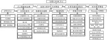
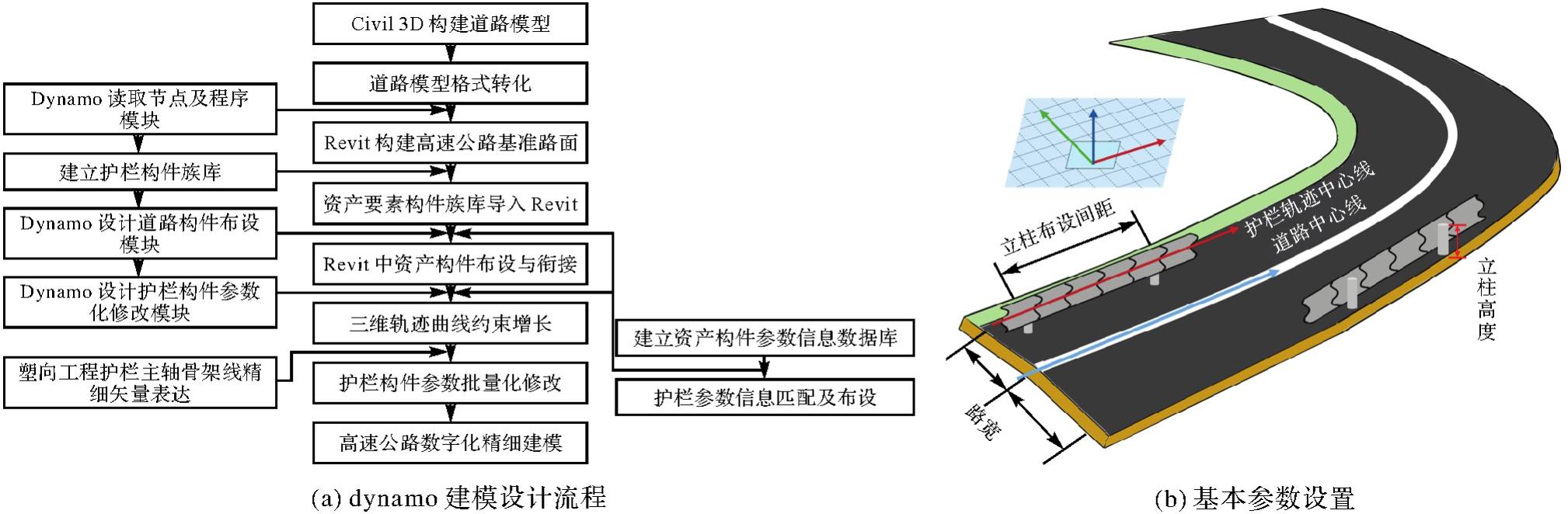
Fig. 1
Workflow of technologies"
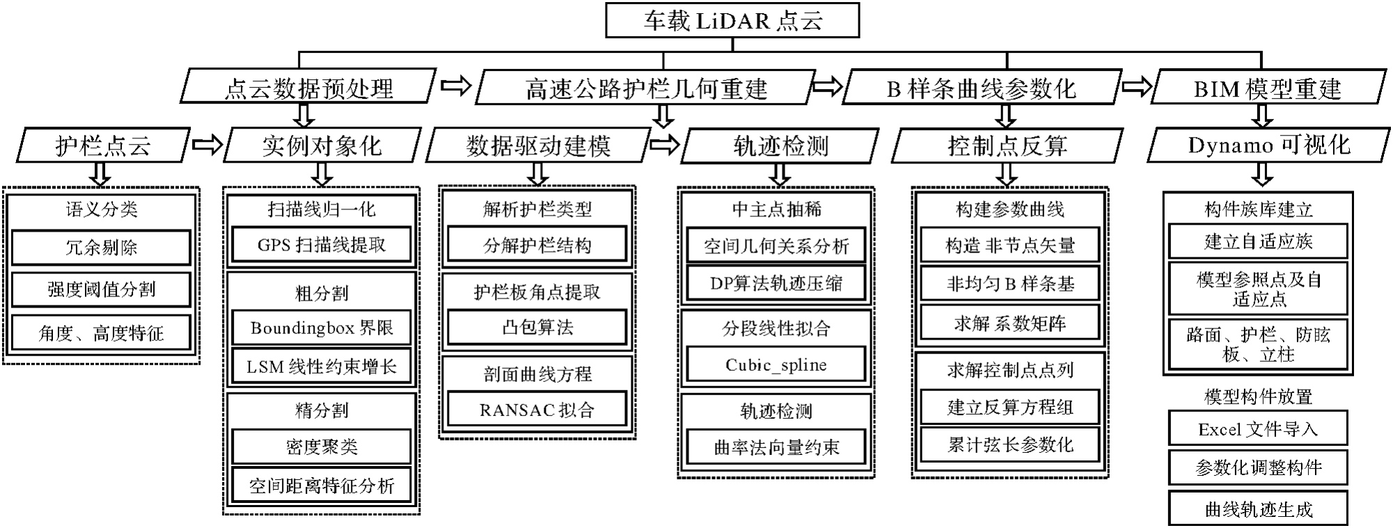
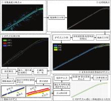
Fig. 2
Flowchart of point clouds guardrail instantiation and vectorization method"


Fig. 3
Four types of highway guardrails"
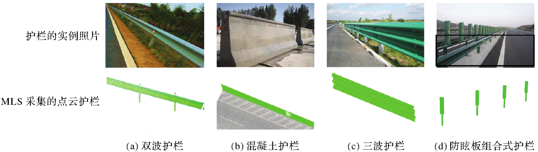
Fig. 4
Profile of guardrail point clouds"
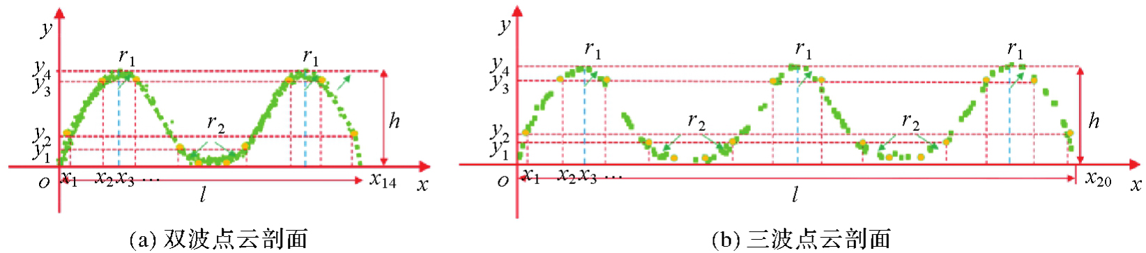
Fig. 5
Curve fitting of guardrail profile"
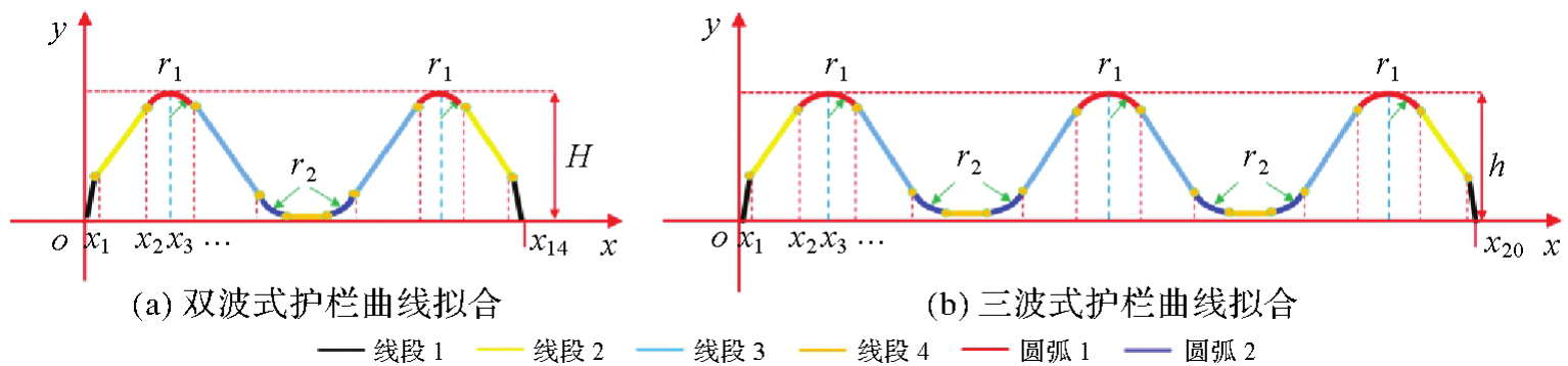
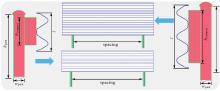
Fig. 6
Example of guardrail installation"
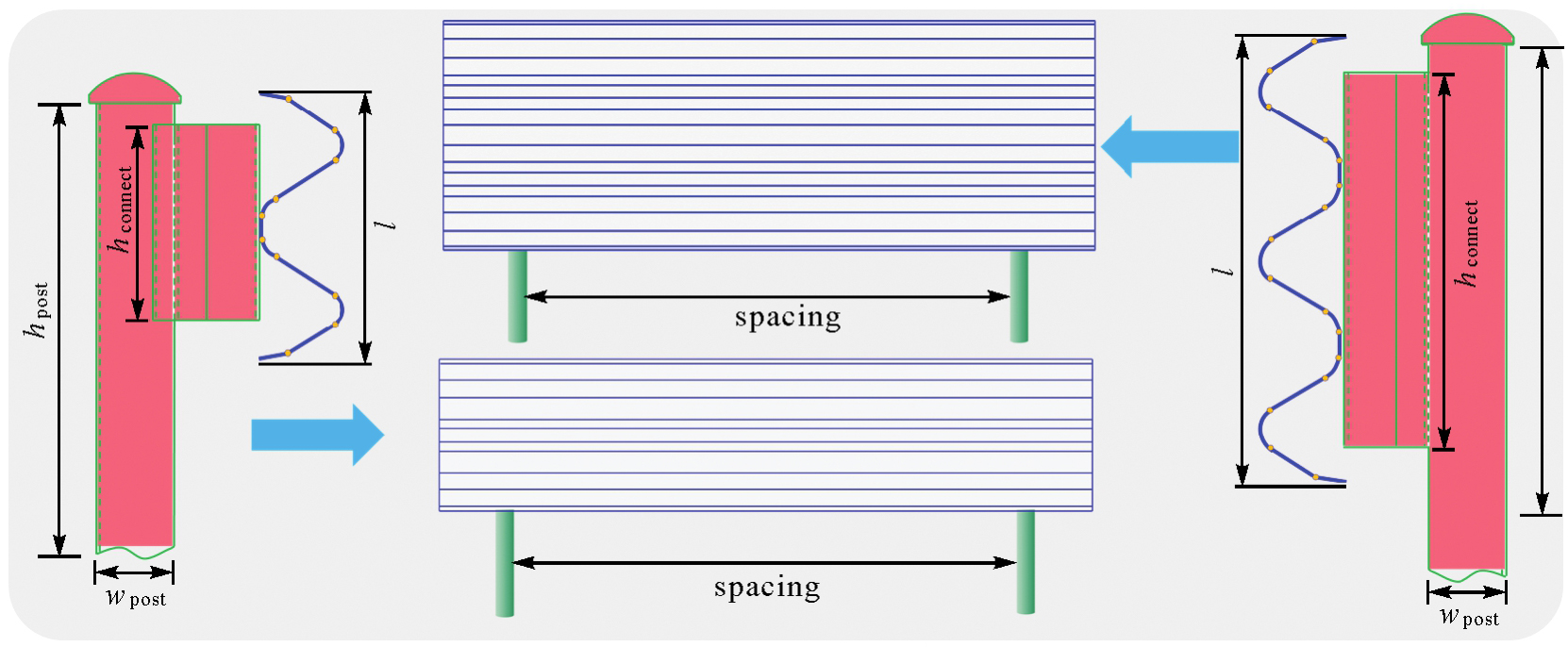
Fig. 7
The geometric relationship of these variables"

Fig. 8
Curvature comparison of different guardrail trajectories"

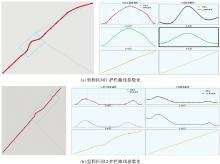
Fig. 9
Trajectory curve parameterization"

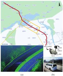
Fig. 10
Experimental Rongchang (RC) highways"

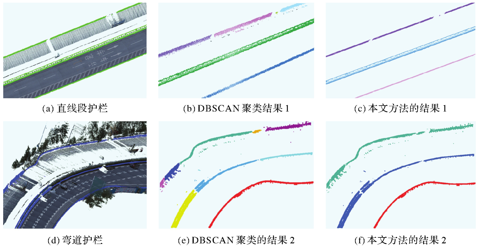
Tab. 1
Comparing the clustering algorithm with the proposed method"
| 方法 | 聚类数量 | |
|---|---|---|
| 直线段 | 弯道 | |
| DBSCAN | 6 | 9 |
| 本文方法 | 3 | 3 |
| 真实值 | 3 | 3 |
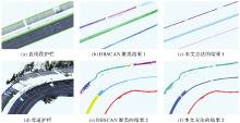
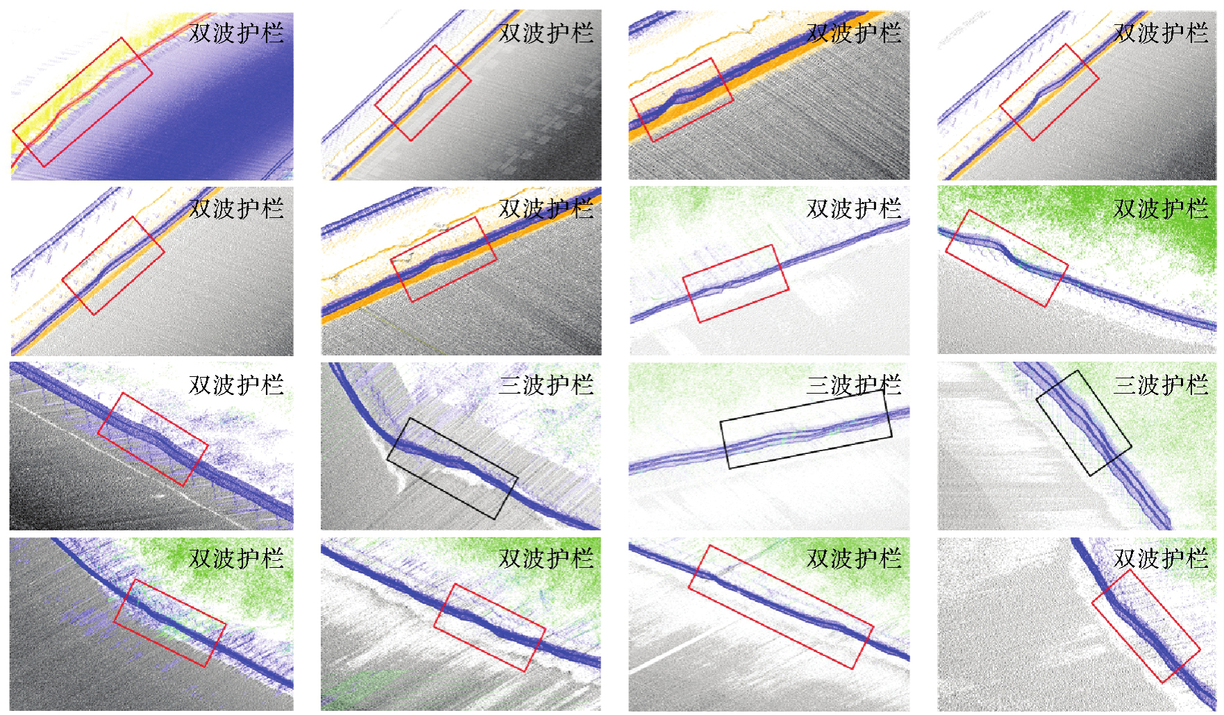
Fig. 11
Instantiation extraction of straight line and curve guardrail"
Tab. 2
Quantitative assessment of guardrail segmentation accuracy"
| 试验段 | 真正例和假负例 | 真正例和假正例 | 真正例 | 精确率/(%) | 召回率/(%) |
|---|---|---|---|---|---|
| 直线 | 302 869 | 302 258 | 299 235 | 99.0 | 98.8 |
| 弯道 | 370 246 | 369 492 | 363 211 | 98.4 | 98.1 |
Fig. 12
Dynamo visual programming mechanism"
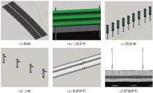
Fig. 13
BIM modeling component family"

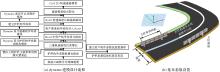
Fig. 14
Modeling route of guardrails"
Tab. 3
Parameters of different types"
| 类型 | 已知参数 | 未知参数 |
|---|---|---|
| dual-wave | H,L,r1,r2,r3,x2,x3,…,x14 | Length,R,Positiondual |
| three-wave | H,L,r1,r2,r3,r4,r5,x2,x3,…,x20 | Length,R,Positionthree |
| pillar | wpost,hpost | Spacingpillar,Positionpillar,offset,R |
| anti-dazzle board | Rectangle,Cylinder | Spacingboard,Positionboard,offset,R |
| concrete barriers | trapezoid | Length,Positionbarriers |
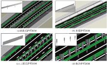
Fig. 15
BIM models of guardrails"

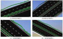
Fig. 16
Parametric BIM model of deformed guardrail"
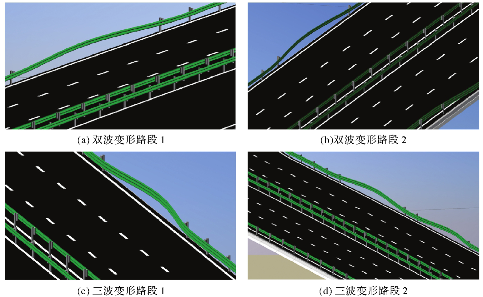
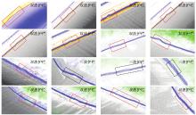
Fig. 17
Example of deformed guardrail detection—Rongchang highways"
Tab. 4
Results of deformed guardrail detection and mileage positioning"
| 护栏 | 变形里程检测/m | 实际里程位置/m | 实际里程范围/m | 里程误差/m |
|---|---|---|---|---|
| 1 | K46+419.9 | K11+422.0 | K46+420—K46+430 | +2.1 |
| 2 | K47+457.8 | K47+459.1 | K47+455—K47+465 | +1.3 |
| 3 | K49+263.0 | K49+263.0 | K49+270—K49+270 | 0 |
| 4 | K49+658.5 | K49+659.2 | K49+655—K49+665 | +0.7 |
| 5 | K50+341.6 | K50+339.1 | K50+335—K50+345 | -1.5 |
| 6 | K50+773.4 | K50+771.7 | K50+765—K50+775 | -1.7 |
| 7 | K51+583.5 | K51+585.1 | K51+580—K50+590 | +1.6 |
| 8 | K52+766.3 | K52+764.8 | K52+760—K52+770 | -1.5 |
| 9 | K52+844.7 | K52+846.4 | K52+840—K52+850 | +1.7 |
| 10 | K54+189.1 | K54+190.3 | K54+185—K54+195 | +1.2 |
| 11 | K55+380.2 | K55+379.0 | K55+375—K55+385 | -0.8 |
| 12 | K56+612.3 | K56+614.1 | K56+610—K56+620 | +1.8 |
| 13 | K57+296.7 | K57+298.0 | K57+290—K57+230 | +1.3 |
| 14 | K58+146.8 | K58+144.6 | K58+140—K58+150 | -2.2 |
| 15 | K58+475.0 | K58+473.6 | K58+470—K58+480 | -1.4 |
| 16 | K59+223.7 | K59+224.9 | K59+220—K59+230 | +1.2 |
Tab. 5
Comparison of mileage positioning methods for deformation guardrail"
| 方法 | 试验路段长度/km | 识别精度/(%) | 里程定位误差/m | 形变护栏数 | 有效检测数 |
|---|---|---|---|---|---|
| 文献[ | 12 | 92.8 | 10.0 | 11 | 10 |
| 本文方法 | 15.5 | 98.7 | 2.2 | 16 | 16 |
| [1] |
李升甫. 高速公路改扩建多源激光扫描数据集成处理与应用关键技术[J]. 测绘学报, 2023, 52(11): 2013. DOI:.
doi: 10.11947/)AGCS.2023.20220487 |
|
LI Shengfu. Multi-source laser scanning data integration processing and application of key technologies for expressway reconstruction and expansion[J]. Acta Geodaetica et Cartographica Sinica, 2023, 52(11): 2013. DOI:.
doi: 10.11947/)AGCS.2023.20220487 |
|
| [2] | 王羽尘, 于斌, 陈晓阳, 等. 基于激光雷达点云的道路几何信息提取与数字化建模研究[J]. 中国公路学报, 2023, 36(3): 45-60. |
| WANG Yuchen, YU Bin, CHEN Xiaoyang, et al. Extraction and digital modeling of road geometric information using LiDAR data point clouds[J]. China Journal of Highway and Transport, 2023, 36(3): 45-60. | |
| [3] | 杜豫川, 刘成龙, 吴荻非, 等. 新一代智慧高速公路系统架构设计[J]. 中国公路学报, 2022, 35(4): 203-214. |
| DU Yuchuan, LIU Chenglong, WU Difei, et al. Framework of the new generation of smart highway[J]. China Journal of Highway and Transport, 2022, 35(4): 203-214. | |
| [4] | HUANG Ming, ZHOU Chuanli, HUO Pengpeng, et al. Expressway guardrail extraction and classification based on slice method[J]. Sensors and Materials, 2020, 32(11): 4005. |
| [5] | RIO J, FERREIRA B, POÇAS-MARTINS J. Expansion of IFC model with structural sensors[J]. Informes de la Construcción, 2013, 65(530): 219-228. |
| [6] | SOILÁN M, JUSTO A, SÁNCHEZ-RODRÍGUEZ A, et al. 3D point cloud to BIM: semi-automated framework to define IFC alignment entities from MLS-acquired LiDAR data of highway roads[J]. Remote Sensing, 2020, 12(14): 2301. |
| [7] | ZHOU Yuzhou, HUANG Ronggang, JIANG Tengping, et al. Highway alignments extraction and 3D modeling from airborne laser scanning point clouds[J]. International Journal of Applied Earth Observation and Geoinformation, 2021, 102: 102429. |
| [8] | SOILÁN M, NÓVOA A, SÁNCHEZ-RODRÍGUEZ A, et al. Fully automated methodology for the delineation of railway lanes and the generation of IFC alignment models using 3D point cloud data[J]. Automation in Construction, 2021, 126: 103684. |
| [9] | BIANCARDO S A, VISCIONE N, CERBONE A, et al. BIM-based design for road infrastructure: a critical focus on modeling guardrails and retaining walls[J]. Infrastructures, 2020, 5(7): 59. |
| [10] |
朱庆, 张利国, 丁雨淋, 等. 从实景三维建模到数字孪生建模[J]. 测绘学报, 2022, 51(6): 1040-1049. DOI:.
doi: 10.11947/j.AGCS.2022.20210640 |
|
ZHU Qing, ZHANG Liguo, DING Yulin, et al. From real 3D modeling to digital twin modeling[J]. Acta Geodaetica et Cartographica Sinica, 2022, 51(6): 1040-1049. DOI:.
doi: 10.11947/j.AGCS.2022.20210640 |
|
| [11] | SOILÁN M, SÁNCHEZ-RODRÍGUEZ A, DEL RÍO-BARRAL P, et al. Review of laser scanning technologies and their applications for road and railway infrastructure monitoring[J]. Infrastructures, 2019, 4(4): 58. |
| [12] | PUENTE I, GONZÁLEZ-JORGE H, MARTÍNEZ-SÁNCHEZ J, et al. Review of mobile mapping and surveying technologies[J]. Measurement, 2013, 46(7): 2127-2145. |
| [13] | WILLIAMS K, OLSEN M J, ROE G V, et al. Synthesis of transportation applications of mobile LiDAR[J]. Remote Sensing, 2013, 5(9): 4652-4692. |
| [14] | MA Lingfei, LI Ying, LI J, et al. Mobile laser scanned point-clouds for road object detection and extraction: a review[J]. Remote Sensing, 2018, 10(10): 1531. |
| [15] |
方莉娜, 沈贵熙, 游志龙, 等. 融合点云和多视图的车载激光点云路侧多目标识别[J]. 测绘学报, 2021, 50(11): 1558-1573. DOI:.
doi: 10.11947/j.AGCS.2021.20210246 |
|
FANG Lina, SHEN Guixi, YOU Zhilong, et al. A joint network of point cloud and multiple views for roadside objects recognition from mobile laser point clouds[J]. Acta Geodaetica et Cartographica Sinica, 2021, 50(11): 1558-1573. DOI:.
doi: 10.11947/j.AGCS.2021.20210246 |
|
| [16] | ZEYBEK M. Extraction of road lane markings from mobile LiDAR data[J]. Transportation Research Record: Journal of the Transportation Research Board, 2021, 2675(5): 30-47. |
| [17] | PǍTRǍUCEAN V, ARMENI I, NAHANGI M, et al. State of research in automatic as-built modelling[J]. Advanced Engineering Informatics, 2015, 29(2): 162-171. |
| [18] | BARAZZETTI L, PREVITALI M, SCAIONI M. Roads detection and parametrization in integrated BIM-GIS using LiDAR[J]. Infrastructures, 2020, 5(7): 55. |
| [19] | NOVÁČEK J, KOHOUT T, VRTAL P, et al. Application of RSA principles to improve the BIM in the road design process with focus on the road restraint systems[J]. The International Archives of the Photogrammetry, Remote Sensing and Spatial Information Sciences, 2022, 46: 159-164. |
| [20] | JUSTO A, SOILÁN M, SÁNCHEZ-RODRÍGUEZ A, et al. Scan-to-BIM for the infrastructure domain: generation of IFC-compliant models of road infrastructure assets and semantics using 3D point cloud data[J]. Automation in Construction, 2021, 127: 103703. |
| [21] | ZHU Hao, GUO Bin. A beam guardrail detection algorithm using LiDAR for intelligent vehicle[C]//Proceedings of 2018 Annual International Conference on CYBER Technology in Automation, Control, and Intelligent Systems. Tianjin: IEEE, 2018: 1398-1402. |
| [22] | JIANG Yu, HE Bei, LIU Li, et al. Effective and robust corrugated beam guardrail detection based on mobile laser scanning data[C]//Proceedings of 2016 International Conference on Intelligent Transportation Systems. Rio de Janeiro: IEEE, 2016: 1540-1545. |
| [23] | YUE Yuanwen, GOUDA M, EL-BASYOUNY K. Automatic detection and mapping of highway guardrails from mobile LiDAR point clouds[C]//Proceedings of 2021 IEEE International Geoscience and Remote Sensing Symposium IGARSS. Brussels: IEEE, 2021: 2520-2523. |
| [24] | GAO Jianlan, CHEN Yiping, JUNIOR J M, et al. Rapid extraction of urban road guardrails from mobile LiDAR point clouds[J]. IEEE Transactions on Intelligent Transportation Systems, 2022, 23(2): 1572-1577. |
| [25] | HU Qingyong, YANG Bo, XIE Linhai, et al. RandLA-Net: efficient semantic segmentation of large-scale point clouds[C]//Proceedings of 2020 IEEE/CVF Conference on Computer Vision and Pattern Recognition. Seattle: IEEE, 2020: 11108-11117. |
| [26] | JIA Xin, ZHU Qing, GE Xuming, et al. Robust guardrail instantiation and trajectory optimization of complex highways based on mobile laser scanning point clouds[J]. Photogrammetric Engineering & Remote Sensing, 2023, 89(3): 151-161. |
| [27] | KEDZIERSKI M, FRYSKOWSKA A. Terrestrial and aerial laser scanning data integration using wavelet analysis for the purpose of 3D building modeling[J]. Sensors, 2014, 14(7): 12070-12092. |
| [28] | MA Lingfei, LI Ying, LI J, et al. Generation of horizontally curved driving lines in HD maps using mobile laser scanning point clouds[J]. IEEE Journal of Selected Topics in Applied Earth Observations and Remote Sensing, 2019, 12(5): 1572-1586. |
| [29] | ZHANG Xiaopeng, LI Hongjun, CHENG Zhanglin. Curvature estimation of 3D point cloud surfaces through the fitting of normal section curvatures[EB/OL]. [2024-06-21]. https://nlpr.ia.ac.cn/2008papers/gjhy/gh129.pdf. |
| [30] | 李振宇, 李林, 朱晓峰, 等. 基于双目视觉的形变护栏检测及里程定位[J]. 交通科技与经济, 2022, 24(2): 24-33. |
| LI Zhenyu, LI Lin, ZHU Xiaofeng, et al. Deformation guardrail detection and mileage location based on binocular vision[J]. Technology & Economy in Areas of Communications, 2022, 24(2): 24-33. |
| [1] | Kefan SHAO, Zengke LI, Meng SUN, Zhenbin LIU, Qi WU. A geomagnetic SLAM method enhanced by multi-source data fusion based on smartphones [J]. Acta Geodaetica et Cartographica Sinica, 2025, 54(10): 1812-1825. |
| [2] | Weitong WU, Chi CHEN, Bisheng YANG, Xiufeng HE. Robust multi-sensor fusion-based odometry method of LiDAR, millimeter-wave radar and IMU in degraded scenes [J]. Acta Geodaetica et Cartographica Sinica, 2025, 54(9): 1677-1686. |
| [3] | Jiayin LIU, Jiatian LI, Guokun CHEN, Xiaohui A, Jingjing WEI, Hao HU. A Markov model for estimating camera pose using target changes [J]. Acta Geodaetica et Cartographica Sinica, 2025, 54(6): 1071-1081. |
| [4] | Luguang LAI, Dongqing ZHAO, Linyang LI, Wenzhe FAN, Xiongqing LI, Pengfei LI. A thermal-inertial odometry with point and line fusion for the weak textured dark scenes [J]. Acta Geodaetica et Cartographica Sinica, 2025, 54(3): 448-460. |
| [5] | Xiaohu LIN, Xin YANG, Wanqiang YAO, Hongwei MA, Bolin MA, Xiongwei MA. A dynamic weighted fusion SLAM method using multi-source sensor data in complex underground spaces [J]. Acta Geodaetica et Cartographica Sinica, 2025, 54(3): 523-535. |
| [6] | Qingzhou MAO, Mengxuan XIA, Qingquan LI, Jing ZHU, Tingli FAN. Global registration method for multi-station point clouds based on the bundle adjustment method [J]. Acta Geodaetica et Cartographica Sinica, 2024, 53(9): 1663-1670. |
| [7] | Dan ZHANG, Weifeng WANG, Guiping HUANG, Xinping WANG, Yanrong LIU, Zhanghong ZHAO. Measurement field error analysis and on site evaluation method for binocular stereo industrial photogrammetry system [J]. Acta Geodaetica et Cartographica Sinica, 2024, 53(9): 1725-1736. |
| [8] | KANG Junhua. End-to-end dense stereo matching based on full convolutional neural network [J]. Acta Geodaetica et Cartographica Sinica, 2022, 51(5): 785-785. |
| [9] | LI Jiatian, WANG Congcong, A Xiaohui, YAN Ling, ZHU Zhihao, GAO Peng. Method of close-range space intersection combining multi-image forward intersection with single hidden layer neural network [J]. Acta Geodaetica et Cartographica Sinica, 2020, 49(6): 736-745. |
| [10] | YAN Li, DAI Jicheng, TAN Junxiang, LIU Hua, CHEN Changjun. Global fine registration of point cloud in LiDAR SLAM based on pose graph [J]. Acta Geodaetica et Cartographica Sinica, 2019, 48(3): 313-321. |
| [11] | ZHANG Chunsen, ZHANG Mengmeng, GUO Bingxuan. Refinement of the 3D Mesh Model Driven by the Image Information [J]. Acta Geodaetica et Cartographica Sinica, 2018, 47(7): 959-967. |
| [12] | YAN Li, TAN Junxiang, LIU Hua, CHEN Changjun. Registration of TLS and MLS Point Cloud Combining Genetic Algorithm with ICP [J]. Acta Geodaetica et Cartographica Sinica, 2018, 47(4): 528-536. |
| [13] | ZHANG Fan, HUANG Yin, HUANG Xianfeng, XU Siqi. 3D Laser Scanning Assisted by Ordinary Plane Mirror for Non-direct Viewing Area [J]. Acta Geodaetica et Cartographica Sinica, 2017, 46(12): 1950-1958. |
| [14] | DENG Fei, WU Yousi, HU Yulei, CUI Hongxia. Position and Pose Estimation of Spherical Panoramic Image with Improved EPnP Algorithm [J]. Acta Geodaetica et Cartographica Sinica, 2016, 45(6): 677-684. |
| [15] | WANG Xiang, ZHANG Yongjun, HUANG Shan, XIE Xunwei. Bandwidth Optimization of Normal Equation Matrix in Bundle Block Adjustment in Multi-baseline Rotational Photography [J]. Acta Geodaetica et Cartographica Sinica, 2016, 45(2): 170-177. |
| Viewed | ||||||
|
Full text |
|
|||||
|
Abstract |
|
|||||