

Acta Geodaetica et Cartographica Sinica ›› 2025, Vol. 54 ›› Issue (11): 1992-2008.doi: 10.11947/j.AGCS.2025.20250138
• Photogrammetry and Remote Sensing • Previous Articles Next Articles
Hao WU1( ), Dongyang HOU2, Jun ZHANG1, Ping ZHANG1, Yuxuan LIU3, Lei DU4, Lu KANG5, Tao CHENG1, Jun CHEN1()
Received:2025-03-31
Revised:2025-09-30
Online:2025-12-15
Published:2025-12-15
Contact:
Jun CHEN
E-mail:wuhao@ngcc.cn;chenjun@ngcc.cn
About author:WU Hao (1983—), male, PhD, professorate senior engineer, majors in dynamic service computing for geographic information. E-mail: wuhao@ngcc.cn
Supported by:CLC Number:
Hao WU, Dongyang HOU, Jun ZHANG, Ping ZHANG, Yuxuan LIU, Lei DU, Lu KANG, Tao CHENG, Jun CHEN. Research on key technologies of remote sensing based natural resources monitoring and supervision platform supported by dynamic service computing[J]. Acta Geodaetica et Cartographica Sinica, 2025, 54(11): 1992-2008.
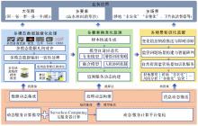
Fig. 1
Overall technical idea"
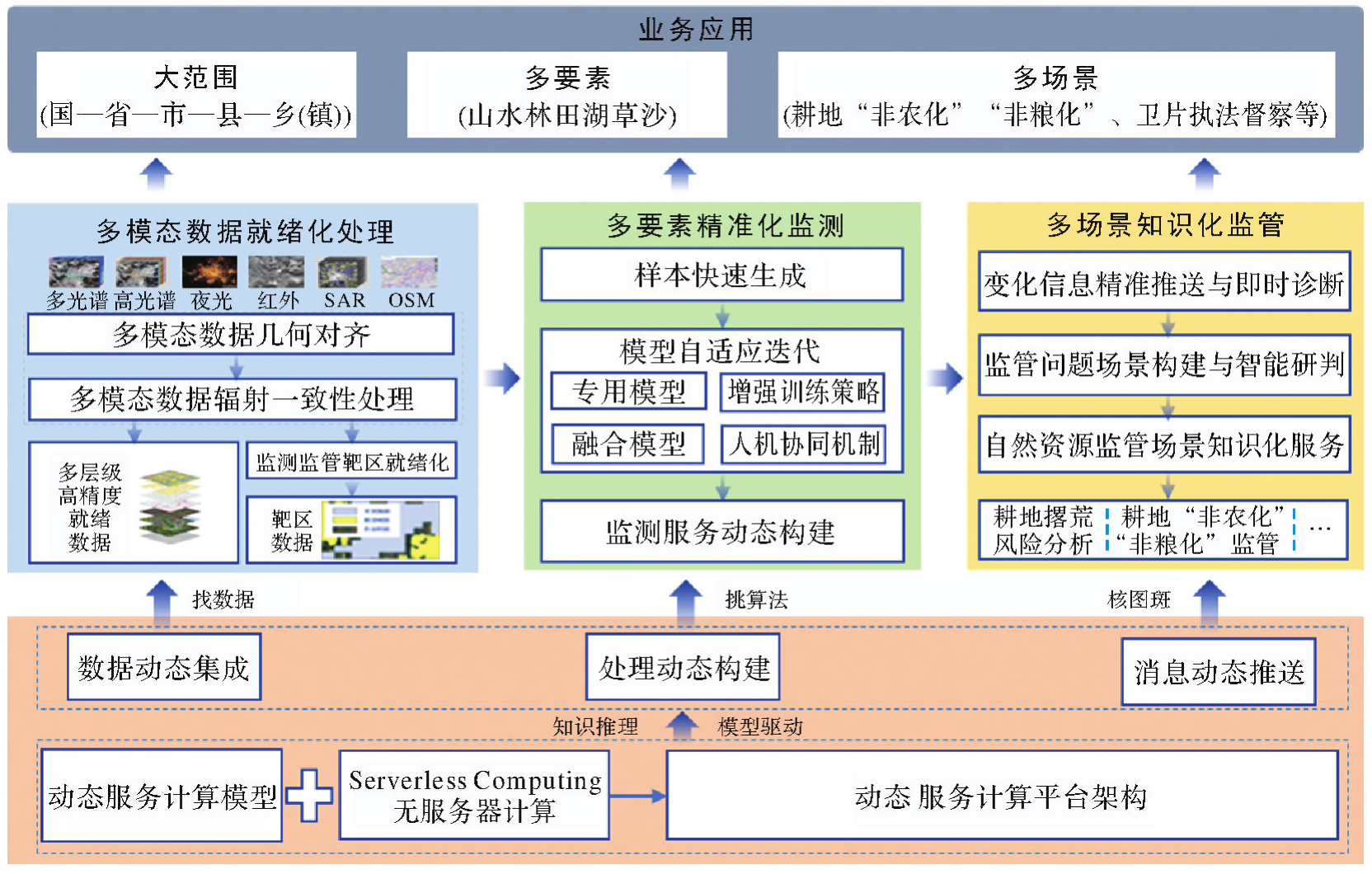
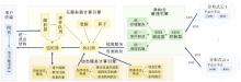
Fig. 2
Dynamic service computing architecture"

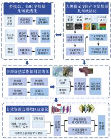
Fig. 3
Main technical roadmap for readiness processing"

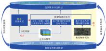
Fig. 4
Technical roadmap for precision monitoring"
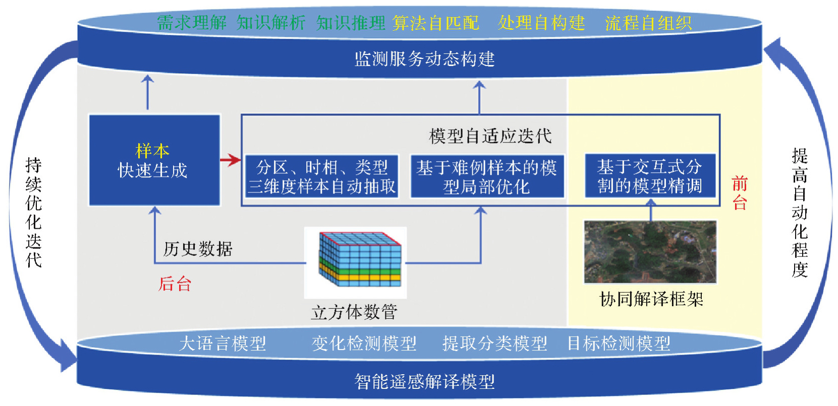
Fig. 5
Technical roadmap for knowledge-based supervision"

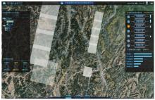
Fig. 6
Remote sensing image automated processing supervision platform interface"


Fig. 7
Remote sensing image monitoring and management platform interface"

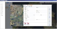
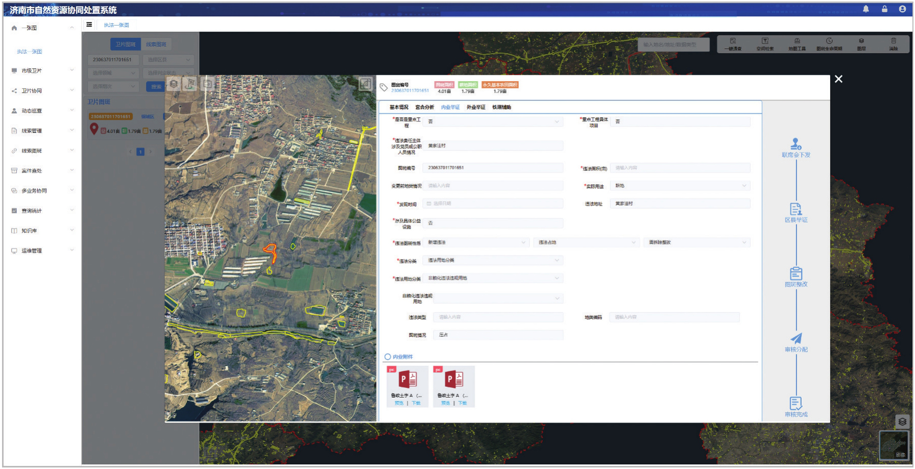
Fig. 8
Natural resources collaborative disposal system interface"
| [1] | 陈军, 武昊, 刘万增, 等. 自然资源时空信息的技术内涵与研究方向[J]. 测绘学报, 2022, 51(7): 1130-1140. DOI: 10.11947/j.AGCS.2022.20210643. |
| CHEN Jun, WU Hao, LIU Wanzeng, et al. Technical connotation and research agenda of natural resources spatio-temporal information[J]. Acta Geodaetica et Cartographica Sinica, 2022, 51(7): 1130-1140. DOI: 10.11947/j.AGCS.2022.20210643. | |
| [2] | 苗前军, 姚艳霞. 自然资源统一调查监测的赋能与升维[J]. 测绘科学, 2022, 47(8): 1-8. |
| MIAO Qianjun, YAO Yanxia. Empowerment and upgrade of unified survey and monitoring of natural resources[J]. Science of Surveying and Mapping, 2022, 47(8): 1-8. | |
| [3] | 陈军, 武昊, 张继贤, 等. 自然资源调查监测技术体系构建的方向与任务[J]. 地理学报, 2022, 77(5): 1041-1055. |
| CHEN Jun, WU Hao, ZHANG Jixian, et al. Building natural resources surveying and monitoring technological system: direction and research agenda[J]. Acta Geographica Sinica, 2022, 77(5): 1041-1055. | |
| [4] | 于法稳, 代明慧, 林珊. 基于粮食安全底线思维的耕地保护:现状、困境及对策[J]. 经济纵横, 2022(12): 9-16. |
| YU Fawen, DAI Minghui, LIN Shan. Cultivated land protection based on bottom line thinking of food security: current situation, difficulties and countermeasures[J]. Economic Review Journal, 2022(12): 9-16. | |
| [5] | 刘向祎, 芦仲进, 邰向荣, 等. 土地利用地图的专题色彩设计:以《第三次全国国土调查工作分类》配色方案设计为例[J]. 测绘通报, 2022(9): 141-144. |
| LIU Xiangyi, LU Zhongjin, TAI Xiangrong, et al. Thematic color design of land use map: a case study of the color scheme design of the classification of the third national land survey[J]. Bulletin of Surveying and Mapping, 2022(9): 141-144. | |
| [6] | 刘立国, 朱聪明. 第三次全国国土调查后年度国土变更调查的技术流程和方法探讨[J]. 自然资源信息化, 2022(1): 7-11. |
| LIU Liguo, ZHU Congming. Discussion on technical process and methods of annual national land change survey after the third national land survey[J]. Natural Resources Informatization, 2022(1): 7-11. | |
| [7] | 中华人民共和国自然资源部办公厅. 自然资源部办公厅关于开展2025年城市国土空间监测工作的通知[EB/OL]. (2025-06-04). [2025-09-30]. https://gi.mnr.gov.cn/202506/t20250606_2885263.html. |
| Ministry of Natural Resources of the People's Republic of China, General Office. Notice of the general office of the Ministry of Natural Resources on carrying out urban territorial space monitoring in 2025[EB/OL]. (2025-06-04)[2025-09-30]. https://gi.mnr.gov.cn/202506/t20250606_2885263.html. | |
| [8] | 中华人民共和国自然资源部办公厅. 自然资源部办公厅关于开展2024年城市国土空间监测工作的通知[EB/OL]. (2024-04-28) [2025-09-30]. https://gi.mnr.gov.cn/202405/t20240509_2844669.html. |
| Ministry of Natural Resources of the People's Republic of China, General Office. Notice of the general office of the Ministry of Natural Resources on carrying out urban territorial space monitoring in 2024[EB/OL]. (2024-04-28)[2025-09-30]. https://gi.mnr.gov.cn/202405/t20240509_2844669.html. | |
| [9] | 自然资源部执法局. 保持严格保护耕地定力切实减轻基层负担——2024年自然资源季度卫片执法工作解读[J]. 资源与人居环境, 2024(3): 18-21. |
| Law Enforcement Bureau of the Ministry of Natural Resources. Upholding strict farmland protection and alleviating grassroots burden: interpretation of 2024 quarterly natural resources satellite image law enforcement work[J]. Resources and Habitant Environment, 2024(3): 18-21. | |
| [10] | 陈军, 艾廷华, 闫利, 等. 智能化测绘的混合计算范式与方法研究[J]. 测绘学报, 2024, 53(6): 985-998. DOI: 10.11947/j.AGCS.2024.20240131. |
| CHEN Jun, AI Tinghua, YAN Li, et al. Hybrid computational paradigm and methods for intelligentized surveying and mapping[J]. Acta Geodaetica et Cartographica Sinica, 2024, 53(6): 985-998. DOI: 10.11947/j.AGCS.2024.20240131. | |
| [11] | 陈军, 武昊, 李松年. 全球地表覆盖领域服务计算的研究进展——以GlobeLand 30为例[J]. 测绘学报, 2017, 46(10): 1526-1533. DOI: 10.11947/j.AGCS.2017.20170411. |
| CHEN Jun, WU Hao, LI Songnian. Research progress of global land domain service computing: take GlobeLand 30 as an example[J]. Acta Geodaetica et Cartographica Sinica, 2017, 46(10): 1526-1533. DOI: 10.11947/j.AGCS.2017.20170411. | |
| [12] | 燕琴, 刘纪平, 董春, 等. 自然资源调查监测分析评价框架设计及关键技术[J]. 地理信息世界, 2022, 29(5): 6-13. |
| YAN Qin, LIU Jiping, DONG Chun, et al. Framework and key technologies for analysis and evaluation of natural resources[J]. Geomatics World, 2022, 29(5): 6-13. | |
| [13] | 张力, 刘玉轩, 孙洋杰, 等. 数字航空摄影三维重建理论与技术发展综述[J]. 测绘学报, 2022, 51(7): 1437-1457. DOI: 10.11947/j.AGCS.2022.20220130. |
| ZHANG Li, LIU Yuxuan, SUN Yangjie, et al. A review of developments in the theory and technology of three-dimensional reconstruction in digital aerial photogrammetry[J]. Acta Geodaetica et Cartographica Sinica, 2022, 51(7): 1437-1457. DOI: 10.11947/j.AGCS.2022.20220130. | |
| [14] | 朱庆, 付萧. 多模态时空大数据可视分析方法综述[J]. 测绘学报, 2017, 46(10): 1672-1677. DOI: 10.11947/j.AGCS.2017.20170286. |
| ZHU Qing, FU Xiao. The review of visual analysis methods of multi-modal spatio-temporal big data[J]. Acta Geodaetica et Cartographica Sinica, 2017, 46(10): 1672-1677. DOI: 10.11947/j.AGCS.2017.20170286. | |
| [15] | 樊仲藜, 张力, 王庆栋, 等. SAR影像和光学影像梯度方向加权的快速匹配方法[J]. 测绘学报, 2021, 50(10): 1390-1403. DOI: 10.11947/j.AGCS.2021.20200587. |
| FAN Zhongli, ZHANG Li, WANG Qingdong, et al. A fast matching method of SAR and optical images using angular weighted orientated gradients[J]. Acta Geodaetica et Cartographica Sinica, 2021, 50(10): 1390-1403. DOI: 10.11947/j.AGCS.2021.20200587. | |
| [16] | 张力, 艾海滨, 许彪, 等. 基于多视影像匹配模型的倾斜航空影像自动连接点提取及区域网平差方法[J]. 测绘学报, 2017, 46(5): 554-564. DOI: 10.11947/j.AGCS.2017.20160571. |
| ZHANG Li, AI Haibin, XU Biao, et al. Automatic tie-point extraction based on multiple-image matching and bundle adjustment of large block of oblique aerial images[J]. Acta Geodaetica et Cartographica Sinica, 2017, 46(5): 554-564. DOI: 10.11947/j.AGCS.2017.20160571. | |
| [17] | SUN Xian, TIAN Yu, LU Wanxuan, et al. From single- to multi-modal remote sensing imagery interpretation: a survey and taxonomy[J]. Science China Information Sciences, 2023, 66(4): 140301. |
| [18] | 李德仁, 张洪云, 金文杰. 新基建时代地球空间信息学的使命[J]. 武汉大学学报(信息科学版), 2022, 47(10): 1515-1522. |
| LI Deren, ZHANG Hongyun, JIN Wenjie. The mission of geo-spatial information science in new infrastructure era[J]. Geomatics and Information Science of Wuhan University, 2022, 47(10): 1515-1522. | |
| [19] | 段依妮, 张立福, 晏磊, 等. 遥感影像相对辐射校正方法及适用性研究[J]. 遥感学报, 2014, 18(3): 597-617. |
| DUAN Yini, ZHANG Lifu, YAN Lei, et al. Relative radiometric correction methods for remote sensing images and their applicability analysis[J]. Journal of Remote Sensing, 2014, 18(3): 597-617. | |
| [20] | 梁丽, 边金虎, 李爱农, 等. 中巴经济走廊DMSP/OLS与NPP/VIIRS夜光数据辐射一致性校正[J]. 遥感学报, 2020, 24(2): 149-160. |
| LIANG Li, BIAN Jinhu, LI Ainong, et al. Consistent intercalibration of nighttime light data between DMSP/OLS and NPP/VIIRS in the China-Pakistan Economic Corridor[J]. Journal of Remote Sensing, 2020, 24(2): 149-160. | |
| [21] | 王阳, 钮新华, 张锷, 等. FY-3B/VIRR真空红外定标辐射响应度一致性校正[J]. 遥感学报, 2023, 27(10): 2295-2306. |
| WANG Yang, NIU Xinhua, ZHANG E, et al. Uniformity correction of radiance responsivity in vacuum infrared calibration for FY-3B/VIRR[J]. National Remote Sensing Bulletin, 2023, 27(10): 2295-2306. | |
| [22] | YUAN Qiangqiang, SHEN Huanfeng, LI Tongwen, et al. Deep learning in environmental remote sensing: achievements and challenges[J]. Remote Sensing of Environment, 2020, 241: 111716. |
| [23] | HOU Zhuolu, LIU Yuxuan, ZHANG Li. POS-GIFT: a geometric and intensity-invariant feature transformation for multimodal images[J]. Information Fusion, 2024, 102: 102027. |
| [24] | 刘玉轩, 张力, 樊仲藜, 等. 面向多模态图像的非线性辐射和几何不变匹配[J]. 光学学报, 2025, 45(6): 329-344. |
| LIU Yuxuan, ZHANG Li, FAN Zhongli, et al. Nonlinear radiation and geometric invariant matching for multimodal imagery[J]. Acta Optica Sinica, 2025, 45(6): 329-344. | |
| [25] | FENG Mengdan, HU Sixing, ANG M H, et al. 2D3D-matchnet: learning to match keypoints across 2D image and 3D point cloud[C]//Proceedings of 2019 International Conference on Robotics and Automation. Montreal: IEEE, 2019: 4790-4796. |
| [26] | GUO Zhou, XU Rui, FENG C C, et al. PIF-Net: a deep point-image fusion network for multimodality semantic segmentation of very high-resolution imagery and aerial point cloud[J]. IEEE Transactions on Geoscience and Remote Sensing, 2024, 62: 5700615. |
| [27] | LI Shengyang, SUN Xian, GU Yanfeng, et al. Recent advances in intelligent processing of satellite video: challenges, methods, and applications[J]. IEEE Journal of Selected Topics in Applied Earth Observations and Remote Sensing, 2023, 16: 6776-6798. |
| [28] | LIU Yuxuan, FAN Zhongli, LI Zhang, et al. Comparative analysis of mainstream multi-source image matching methods on remote sensing imagery[C]//Proceedings of 2024 IEEE International Geoscience and Remote Sensing Symposium. Athens: IEEE, 2024: 2986-2990. |
| [29] | 柳思聪, 都科丞, 郑永杰, 等. 人工智能时代的遥感变化检测技术:继承、发展与挑战[J]. 遥感学报, 2023, 27(9): 1975-1987. |
| LIU Sicong, DU Kecheng, ZHENG Yongjie, et al. Remote sensing change detection technology in the era of artificial intelligence: inheritance, development and challenges[J]. National Remote Sensing Bulletin, 2023, 27(9): 1975-1987. | |
| [30] | HANG Renlong, YANG Ping, ZHOU Feng, et al. Multiscale progressive segmentation network for high-resolution remote sensing imagery[J]. IEEE Transactions on Geoscience and Remote Sensing, 2022, 60: 5412012. |
| [31] | ZHAO Yang, GUO Peng, SUN Zihao, et al. ResiDualGAN: resize-residual dualGAN for cross-domain remote sensing images semantic segmentation[J]. Remote Sensing, 2023, 15(5): 1428. |
| [32] | ZHENG Jianwei, SHAO Anhao, YAN Yidong, et al. Remote sensing semantic segmentation via boundary supervision-aided multiscale channelwise cross attention network[J]. IEEE Transactions on Geoscience and Remote Sensing, 2023, 61: 4405814. |
| [33] | 龚健雅, 许越, 胡翔云, 等. 遥感影像智能解译样本库现状与研究[J]. 测绘学报, 2021, 50(8): 1013-1022. DOI: 10.11947/j.AGCS.2021.20210085. |
| GONG Jianya, XU Yue, HU Xiangyun, et al. Status analysis and research of sample database for intelligent interpretation of remote sensing image[J]. Acta Geodaetica et Cartographica Sinica, 2021, 50(8): 1013-1022. DOI: 10.11947/j.AGCS.2021.20210085. | |
| [34] | 陶超, 阴紫薇, 朱庆, 等. 遥感影像智能解译:从监督学习到自监督学习[J]. 测绘学报, 2021, 50(8): 1122-1134. DOI: 10.11947/j.AGCS.2021.20210089. |
| TAO Chao, YIN Ziwei, ZHU Qing, et al. Remote sensing image intelligent interpretation: from supervised learning to self-supervised learning[J]. Acta Geodaetica et Cartographica Sinica, 2021, 50(8): 1122-1134. DOI: 10.11947/j.AGCS.2021.20210089. | |
| [35] | 刘洋, 廖薇, 徐震. 融合表字段的NL2SQL多任务学习方法[J]. 计算机应用研究, 2024, 41(9): 2800-2804. |
| LIU Yang, LIAO Wei, XU Zhen. Multi-task learning method for NL2SQL with fused table columns[J]. Application Research of Computers, 2024, 41(9): 2800-2804. | |
| [36] | 雷鸣. 自然语言提示驱动的智能信息分析模式研究[J]. 情报理论与实践, 2025, 48(1): 168-175. |
| LEI Ming. Research on the intelligent information analysis mode driven by natural language prompting[J]. Information Studies (Theory & Application), 2025, 48(1): 168-175. | |
| [37] | 翟雪松, 季爽, 焦丽珍, 等. 基于多智能体的人机协同解决复杂学习问题实证研究[J]. 开放教育研究, 2024, 30(3): 63-73. |
| ZHAI Xuesong, JI Shuang, JIAO Lizhen, et al. Empirical investigation of human-machine collaboration in solving complex learning problems through a LLM-based multi-agent framework[J]. Open Education Research, 2024, 30(3): 63-73. | |
| [38] | ZHAO Xinjie, BLUM M, YANG Rui, et al. AGENTiGraph: an interactive knowledge graph platform for LLM-based chatbots utilizing private data[EB/OL]. [2025-09-30]. https://arxiv.org/abs/2410.11531. |
| [39] | 张雪英, 张春菊, 吴明光, 等. 顾及时空特征的地理知识图谱构建方法[J]. 中国科学:信息科学, 2020, 50(7): 1019-1032. |
| ZHANG Xueying, ZHANG Chunju, WU Mingguang, et al. Spatiotemporal features based geographical knowledge graph construction[J]. Scientia Sinica (Informationis), 2020, 50(7): 1019-1032. | |
| [40] | 周成虎, 王华, 王成善, 等. 大数据时代的地学知识图谱研究[J]. 中国科学:地球科学, 2021, 51(7): 1070-1079. |
| ZHOU Chenghu, WANG Hua, WANG Chengshan, et al. Research on geoscience knowledge graph in the big data era[J]. Scientia Sinica (Terrae), 2021, 51(7): 1070-1079. | |
| [41] | 李彦胜, 武康, 欧阳松, 等. 地学知识图谱引导的遥感影像语义分割[J]. 遥感学报, 2024, 28(2): 455-469. |
| LI Yansheng, WU Kang, OUYANG Song, et al. Geographic knowledge graph-guided remote sensing image semantic segmentation[J]. National Remote Sensing Bulletin, 2024, 28(2): 455-469. | |
| [42] | 余铁桥, 罗亚, 张耘逸, 等. 国土空间信息模型的总体架构与构建路径研究[J]. 自然资源信息化, 2024(6): 46-53, 62. |
| YU Tieqiao, LUO Ya, ZHANG Yunyi, et al. Study on the overall architecture and construction path of territorial information model[J]. Natural Resources Informatization, 2024(6): 46-53, 62. | |
| [43] | 程立海, 崔荣国, 董瑾, 等. 自然资源和国土空间大数据技术应用框架[J]. 地球信息科学学报, 2024, 26(4): 881-897. |
| CHENG Lihai, CUI Rongguo, DONG Jin, et al. Technical application framework of big data on natural resources and territorial space[J]. Journal of Geo-information Science, 2024, 26(4): 881-897. | |
| [44] | 段志军. 基于城市信息模型的新型智慧城市平台建设探讨[J]. 测绘与空间地理信息, 2020, 43(8): 138-139, 142. |
| DUAN Zhijun. Discussion on construction of new-type smart cities platform based on city information modeling[J]. Geomatics & Spatial Information Technology, 2020, 43(8): 138-139, 142. | |
| [45] | 韩青, 杨瀚霆, 姚博文, 等. 国土空间信息模型建设思路借鉴与思考[J]. 自然资源信息化, 2025(1): 18-25. |
| HAN Qing, YANG Hanting, YAO Bowen, et al. Reference and reflection on the construction approach of territory information model[J]. Natural Resources Informatization, 2025(1): 18-25. | |
| [46] | ZENG Jie, LUO Ting, CHEN Wanxu, et al. Assessing and mapping cropland abandonment risk in China[J]. Land Degradation & Development, 2024, 35(8): 2738-2753. |
| [47] | MA Yongchao, WANG Jiasheng, XIONG Jianhong, et al. Risk assessment for cropland abandonment in mountainous area based on AHP and PCA: take Yunnan province in China as an example[J]. Ecological Indicators, 2024, 158: 111287. |
| [48] | HAN Ji, HAYASHI Y, CAO Xin, et al. Application of an integrated system dynamics and cellular automata model for urban growth assessment: a case study of Shanghai, China[J]. Landscape and Urban Planning, 2009, 91(3): 133-141. |
| [49] | SU Yue, WANG Cheng, HUANG Yue, et al. Study on spatio-temporal pattern changes and prediction of arable land abandonment in developed area: take Pingyang county as an example[J]. Sustainability, 2022, 14(17): 10560. |
| [50] | SONG Wei, YANG Dazhi, WANG Yanwei. Integrating an abandoned farmland simulation model (AFSM) using system dynamics and CLUE-S for sustainable agriculture[J]. Agricultural Systems, 2024, 219: 104063. |
| [51] | WU Zhaohui, DENG Shuiguang, WU Jian. Service computing: concept, method and technology[M]. Orlando: Academic Press, Inc., 2014. |
| [52] | 武昊, 张俊, 陈军. 地表覆盖信息服务标准研究[J]. 地理信息世界, 2018, 25(5): 29-34. |
| WU Hao, ZHANG Jun, CHEN Jun. Research on standards of land cover information service[J]. Geomatics World, 2018, 25(5): 29-34. | |
| [53] | FAN Zhongli, WANG Mi, PI Yingdong, et al. A robust oriented filter-based matching method for multisource, multitemporal remote sensing images[J]. IEEE Transactions on Geoscience and Remote Sensing, 2023, 61: 4703316. |
| [54] | LI Zijun, GUO Linsong, CHENG Jiagan, et al. The serverless computing survey: a technical primer for design architecture[J]. ACM Computing Surveys, 2022, 54(10s): 1-34. |
| [55] | TOOSI A N, JAVADI B, IOSUP A, et al. Serverless computing for next-generation application development[J]. Future Generation Computer Systems, 2025, 164: 107573. |
| [56] | KAUR A, RAMA KRISHNA C, PATIL N V. A comprehensive review on software-defined networking (SDN) and DDoS attacks: ecosystem, taxonomy, traffic engineering, challenges and research directions[J]. Computer Science Review, 2025, 55: 100692. |
| [57] | WANG Yaoxiang, WU Zhiyong, YAO Junfeng, et al. TDAG: a multi-agent framework based on dynamic task decomposition and agent generation[J]. Neural Networks, 2025, 185: 107200. |
| [58] | GORELICK N, HANCHER M, DIXON M, et al. Google Earth Engine: planetary-scale geospatial analysis for everyone[J]. Remote Sensing of Environment, 2017, 202: 18-27. |
| [59] | 程伟, 钱晓明, 李世卫, 等. 时空遥感云计算平台PIE-Engine Studio的研究与应用[J]. 遥感学报, 2022, 26(2): 335-347. |
| CHENG Wei, QIAN Xiaoming, LI Shiwei, et al. Research and application of PIE-Engine Studio for spatiotemporal remote sensing cloud computing platform[J]. National Remote Sensing Bulletin, 2022, 26(2): 335-347. | |
| [60] | ZHANG Xianyuan, XIANG Longgang, YUE Peng, et al. Open geospatial engine: a cloud-based spatiotemporal computing platform[J]. ISPRS Annals of the Photogrammetry, Remote Sensing and Spatial Information Sciences, 2024, 10: 453-459. |
| [61] | 宁晓刚, 张翰超, 张瑞倩. 遥感影像高可信智能不变检测技术框架与方法实践[J]. 测绘学报, 2024, 53(6): 1098-1112. DOI: 10.11947/j.AGCS.2024.20230405. |
| NING Xiaogang, ZHANG Hanchao, ZHANG Ruiqian. Practical framework and methodology for high-performance intelligent invariant detection in remote sensing imagery[J]. Acta Geodaetica et Cartographica Sinica, 2024, 53(6): 1098-1112. DOI: 10.11947/j.AGCS.2024.20230405. |
| [1] | CHENG Dayu. Study on Dynamic Service Computing of HSOSCS [J]. Acta Geodaetica et Cartographica Sinica, 2014, 43(9): 989-989. |
| Viewed | ||||||
|
Full text |
|
|||||
|
Abstract |
|
|||||