

Acta Geodaetica et Cartographica Sinica ›› 2026, Vol. 55 ›› Issue (4): 647-657.doi: 10.11947/j.AGCS.2026.20250319
• Coastal and Marine Surveying, Mapping, and Remote Sensing • Previous Articles Next Articles
Yi GAO1( ), Xin LIU1(), Daocheng YU2, Shaoshuai YA1, Shaofeng BIAN3, Heping SUN4, Jinyun GUO1
Received:2025-08-11
Revised:2026-03-12
Online:2026-05-11
Published:2026-05-11
Contact:
Xin LIU
E-mail:2250291272@qq.com;xinliu1969@126.com
About author:GAO Yi (2001—), male, postgraduate, majors in satellite altimetry data processing and application. E-mail: 2250291272@qq.com
Supported by:CLC Number:
Yi GAO, Xin LIU, Daocheng YU, Shaoshuai YA, Shaofeng BIAN, Heping SUN, Jinyun GUO. An automated seamount detection method integrating vertical gravity gradient anomaly and seafloor topographic models[J]. Acta Geodaetica et Cartographica Sinica, 2026, 55(4): 647-657.
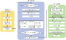
Fig. 1
Flowchart of ISDHEB algorithm"
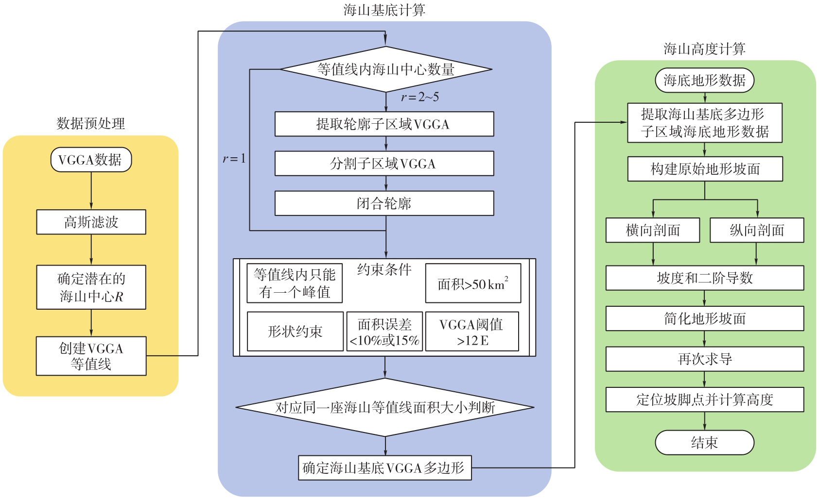
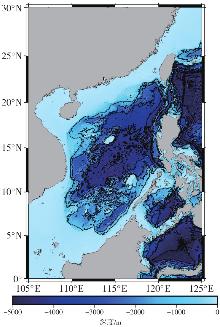
Fig. 2
Seafloor topography map of South China Sea and its surrounding areas (GEBCO_2024)"
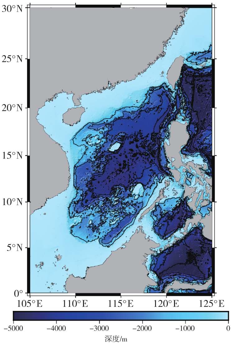
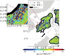
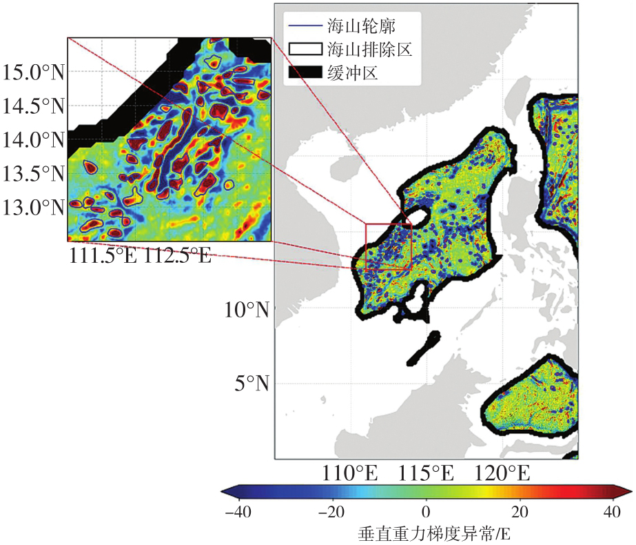
Fig. 3
Seamount base contours in the experimental area identified by the ISDHEB algorithm"
Tab. 1
Statistical results of seamount heights"
| 海山高度/m | 数量 |
|---|---|
| 小型海山(100<h<1000) | 139 |
| 中型海山(1000<h<3000) | 126 |
| 大型海山(h>3000) | 13 |
Fig. 4
Spatial distribution and height classification of seamounts detected in the study area"
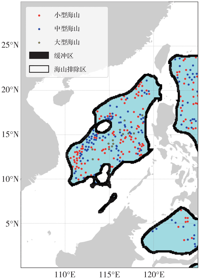

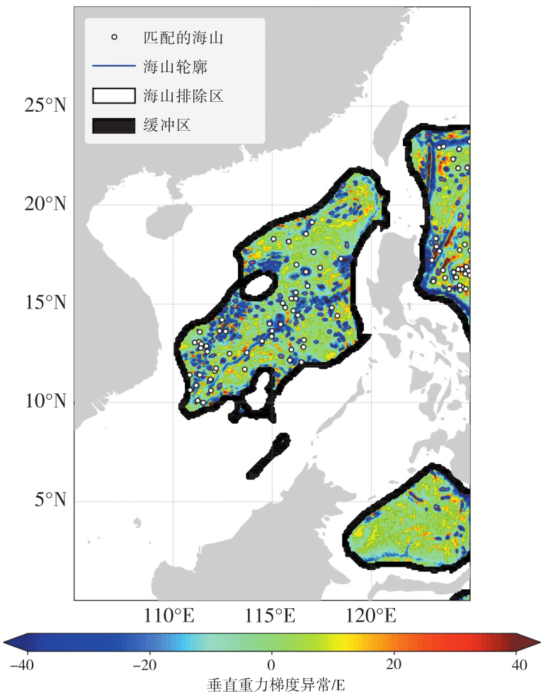
Fig. 5
Comparative analysis of ISDHEB detection results with the SIO 2023 seamount catalog"
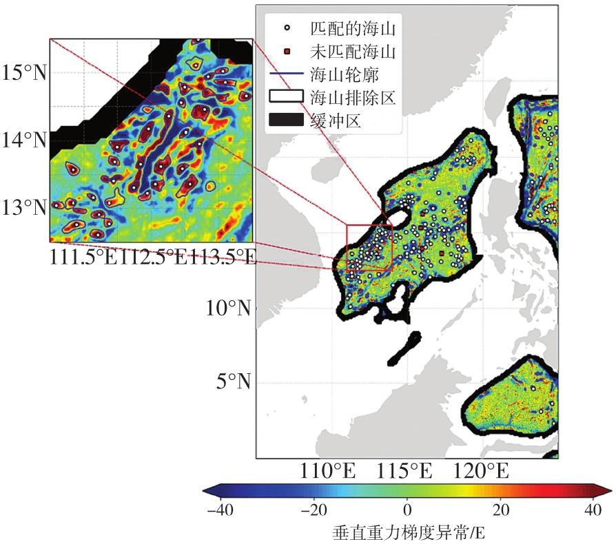
Fig. 6
Signatures of four undetected seamounts in VGGA and seafloor topography"
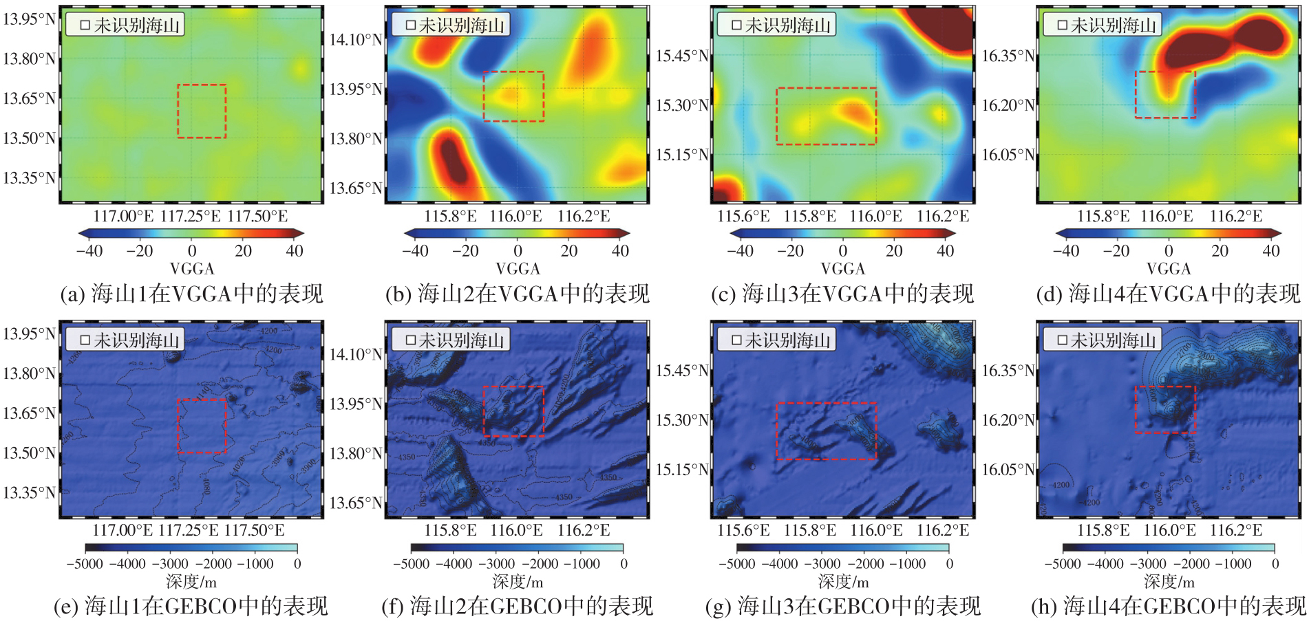
Fig. 7
Analysis of VGGA signals and GEBCO topographic features for some targets that failed visual verification"

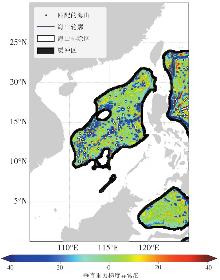
Fig. 8
Comparison of detection results with seamounts in the GEBCO dataset"
Tab. 2
Seamount height error metrics"
| 算法 | MAX | MIN | 平均值 | STD | RMSE |
|---|---|---|---|---|---|
| ISDHEB | 668.5 | -912 | -155.6 | 318.4 | 354.4 |
| SIO | 1260 | -1467 | 2.13 | 684.6 | 684.6 |
| [1] | MENARD H W. Marine geology of the pacific[M]. New York: McGraw-Hill, 1964. |
| [2] | ZIOLKOWSKI T, DEVEY C W, KOSCHMIDER A. Detecting small seamounts in multibeam data using convolutional neural networks[J]. Frontiers in Marine Science, 2025, 12: 1613061. |
| [3] | WESSEL P. Seamount characteristics[M]//PITCHER T J, MORATO T, HART P J B, et al. Seamounts: Ecology, Fisheries, and Conservation. Oxford: Blackwell Publishing, 2007: 3-25. |
| [4] |
李倩倩, 鲍李峰, 王勇. 2022汤加海底火山活动的测高海面观测异常分析[J]. 测绘学报, 2024, 53(2): 263-273. DOI: .
doi: 10.11947/j.AGCS.2024.20230277 |
|
LI Qianqian, BAO Lifeng, WANG Yong. Altimetric sea surface observation anomaly analysis of the 2022 Tonga submarine volcanic activity[J]. Acta Geodaetica et Cartographica Sinica, 2024, 53(2): 263-273. DOI: .
doi: 10.11947/j.AGCS.2024.20230277 |
|
| [5] | WEI X, ZHANG Y, SHI X F, et al. Geochronological and geochemical constraints on the petrogenesis and geodynamic process of Hemler, Vlinder, and Il'ichev seamount lavas in NW Pacific[J]. Science China Earth Sciences, 2024, 67(7): 1856-1871. |
| [6] | ZHOU W, LI G, LUO Y, et al. Holocene sea level variations drive formation of a coral atoll in southern South China Sea[J]. Global and Planetary Change, 2025, 251: 104835. |
| [7] | MAYER L, JAKOBSSON M, ALLEN G, et al. The nippon foundation-GEBCO seabed 2030 project: the quest to see the world's oceans completely mapped by 2030[J]. Geosciences, 2018, 8(2): 63. |
| [8] | 郭金运, 张鸿飞, 李真, 等. 多源船载重力异常数据的联合再处理:以墨西哥湾为例[J]. 武汉大学学报(信息科学版), 2025, 50(7): 1277-1290. |
| GUO Jinyun, ZHANG Hongfei, LI Zhen, et al. Joint reprocessing of multi-sources shipborne gravity anomalies: a case study of Gulf of Mexico[J]. Geomatics and Information Science of Wuhan University, 2025, 50(7): 1277-1290. | |
| [9] | XU H, YU J, WAN X, et al. An expression for gravity generated by an anomalous geological body and its application in bathymetry inversion[J]. Journal of Geodesy and Geoinformation Science, 2021, 4(4): 63-73. |
| [10] | SANDWELL D T, SMITH W H F. Marine gravity anomalies from GEOSAT and ERS-1 satellite altimetry[J]. Journal of Geophysical Research, 1997, 102(B5): 10039-10054. |
| [11] |
李真, 郭金运, 孙中苗, 等, 基于ICESa-2多波東激光测高数据的全球海洋重力异常反演分析[J]. 测绘学报, 2024, 53(2): 252-262. DOI: .
doi: 10.11947/j.AGCS.2024.20230207 |
|
LI Zhen, GUO Jinyun, SUN Zhongmiao, et al. Global marine gravity anomalies recovered from multi-beam laser altimeter data of ICESat-2[J]. Acta Geodaetica et Cartographica Sinica, 2024, 53(2): 252-262. DOI: .
doi: 10.11947/j.AGCS.2024.20230207 |
|
| [12] | CRAIG C H, SANDWELL D T. Global distribution of seamounts from Seasat profiles[J]. Journal of Geophysical Research, 1988, 93(B9): 10408-10420. |
| [13] | BAUDRY N, CALMANT S. 3D modelling of seamount topography from satellite altimetry[J]. Geophysical Research Letters, 1991, 18(6): 1143-1146. |
| [14] | YESSON C, CLARK M R, TAYLOR M L, et al. The global distribution of seamounts based on 30 arc seconds bathymetry data[J]. Deep Sea Research PartⅠ: Oceanographic Research Papers, 2011, 58(4): 442-453. |
| [15] | WESSEL P, SANDWELL D T, KIM S S. The global seamount census[J]. Oceanography, 2010, 23(1): 24-33. |
| [16] | SANDWELL D T, MÜLLER R D, SMITH W H F, et al. New global marine gravity model from CryoSat-2 and Jason-1 reveals buried tectonic structure[J]. Science, 2014, 346(6205): 65-67. |
| [17] | NOVÁK P, ŠPRLÁK M, PITOŇÁK M. On determination of the geoid from measured gradients of the Earth's gravity field potential[J]. Earth-Science Reviews, 2021, 221: 103773. |
| [18] | 郭金运, 吴渴知, 金鑫, 等. 高精度三维跟踪抛物运动的重力垂直梯度测量方法[J]. 武汉大学学报(信息科学版), 2025, 50(3): 462-468. |
| GUO Jinyun, WU Kezhi, JIN Xin, et al. A method to determine vertical gravity gradient by high-precision 3D tracking parabolic motion[J]. Geomatics and Information Science of Wuhan University, 2025, 50(3): 462-468. | |
| [19] | KIM S S, WESSEL P. New global seamount census from altimetry-derived gravity data[J]. Geophysical Journal International, 2011, 186(2): 615-631. |
| [20] | ZHOU R C, LIU X, GUO J Y, et al. Inverting vertical gravity anomaly gradients using multidirectional data from a mean sea surface model: the case of the Arabian Sea[J]. Earth, Planets and Space, 2024, 76: 170. |
| [21] | ZHOU R C, GUO J Y, YA S S, et al. SDUST2023VGGA: a global ocean vertical gradient of gravity anomaly model determined from multidirectional data from mean sea surface[J]. Earth System Science Data, 2025, 17(2): 817-836. |
| [22] | WESSEL P. Sizes and ages of seamounts using remote sensing: implications for intraplate volcanism[J]. Science, 1997, 277(5327): 802-805. |
| [23] | GEVORGIAN J, SANDWELL D T, YU Y, et al. Global distribution and morphology of small seamounts[J]. Earth and Space Science, 2023, 10(1): e2022EA002331. |
| [24] | MORROW R, FU L L, ARDHUIN F, et al. Global observations of fine-scale ocean surface topography with the surface water and ocean topography (SWOT) mission[J]. Frontiers in Marine Science, 2019, 6: 232. |
| [25] |
押少帅, 刘新, 周瑞宸, 等. 基于科学阶段SWOT/KaRIn测高数据反演高精度的垂直重力异常梯度模型[J]. 测绘学报, 2025, 54(9): 1583-1595. DOI: .
doi: 10.11947/j.AGCS.2025.20240520 |
|
YA Shaoshuai, LIU Xin, ZHOU Ruichen, et al. High-accuracy vertical gradient of gravity anomaly model determined from SWOT/KaRIn altimetry data during scientific phase[J]. Acta Geodaetica et Cartographica Sinica, 2025, 54(9): 1583-1595. DOI: .
doi: 10.11947/j.AGCS.2025.20240520 |
|
| [26] | FU L L, PAVELSKY T, CRETAUX J F, et al. The surface water and ocean topography mission: a breakthrough in radar remote sensing of the ocean and land surface water[J]. Geophysical Research Letters, 2024, 51(4): e2023GL107652. |
| [27] | GUO H, WAN X, WANG H. Validation of just-released SWOT L2 KaRIn beta prevalidated data based on restore the marine gravity field and its application[J]. IEEE Journal of Selected Topics in Applied Earth Observations and Remote Sensing, 2024, 17: 7878-7887. |
| [28] | YU D, HWANG C, ANDERSEN O B, et al. Gravity recovery from SWOT altimetry using geoid height and geoid gradient[J]. Remote Sensing of Environment, 2021, 265: 112650. |
| [29] | YU D, WENG Z, HWANG C, et al. Seamount detection using SWOT-derived vertical gravity gradient: advancements and challenges[J]. Geophysical Journal International, 2024, 237(3): 1780-1793. |
| [30] | FORNARI D J, PERFIT M R, ALLAN J F, et al. Small-scale heterogeneities in depleted mantle sources: near-ridge seamount lava geochemistry and implications for mid-ocean-ridge magmatic processes[J]. Nature, 1988, 331(6156): 511-513. |
| [31] |
郭金运, 金鑫, 边少锋, 等. 垂线偏差测量的固体潮和海潮改正[J]. 测绘学报, 2022, 51(7): 1215-1224. DOI: .
doi: 10.11947/j.AGCS.2022.20220104 |
|
GUO Jinyun, JIN Xin, BIAN Shaofeng, et al. Corrections of solid earth tide and ocean tide for measurement of deflection of the vertical[J]. Acta Geodaetica et Cartographica Sinica, 2022, 51(7): 1215-1224. DOI: .
doi: 10.11947/j.AGCS.2022.20220104 |
|
| [32] | GONZALEZ R C, WOODS R E. Digital image processing[M]. 4th ed. London: Pearson, 2017. |
| [33] | 吴自银, 李家彪, 阳凡林, 等. 一种大陆坡脚点自动识别与综合判断方法[J]. 测绘学报, 2014, 43(2): 170-177. |
| WU Ziyin, LI Jiabiao, YANG Fanlin, et al. An automatic identification and comprehensive judgment method for the foot of continental slope[J]. Acta Geodaetica et Cartographica Sinica, 2014, 43(2): 170-177. | |
| [34] | OTSU N. A threshold selection method from gray-level histograms[J]. IEEE Transactions on Systems, Man, and Cybernetics, 1979, 9(1): 62-66. |
| [35] | 中国科学院地理研究所. 中国1∶100万土地貌制图规范[M]. 北京: 科学出版社, 1987. |
| Institute of Geography, Chinese Academy of Sciences. Specifications for China's 1∶1 000 000 landform mapping[M]. Beijing: Science Press, 1987. | |
| [36] | SANDWELL D T, HARPER H, TOZER B, et al. Gravity field recovery from geodetic altimeter missions[J]. Advances in Space Research, 2021, 68(2): 1059-1072. |
| [37] | YU Y, SANDWELL D T, DIBARBOURE G. Abyssal marine tectonics from the SWOT mission[J]. Science, 2024, 386(6722): 1251-1256. |
| [38] | TOZER B, SANDWELL D T, SMITH W H F, et al. Global bathymetry and topography at 15 arc sec: SRTM15+[J]. Earth and Space Science, 2019, 6(10): 1847-1864. |
| [1] | Shaoshuai YA, Xin LIU, Ruichen ZHOU, Zhen LI, Shaofeng BIAN, Jinyun GUO. High accuracy vertical gradient of gravity anomaly model determined from SWOT/KaRIn altimetry data during scientific phase [J]. Acta Geodaetica et Cartographica Sinica, 2025, 54(9): 1583-1595. |
| [2] | FAN Diao, LI Shanshan, OUYANG Yongzhong, MENG Shuyu, CHEN Cheng, XING Zhibin, ZHANG Chi. Seafloor topography inversion using least square collocation considering nonlinear term [J]. Acta Geodaetica et Cartographica Sinica, 2021, 50(7): 953-971. |
| [3] | WANG Jiasheng, YANG Kun, ZHU Yanhui, XIONG Jianhong. Euclidean distance transform on the sea based on cellular automata modeling [J]. Acta Geodaetica et Cartographica Sinica, 2019, 48(3): 384-392. |
| [4] | DING Kai, LI Qingquan, ZHU Jiasong, WANG Chisheng, GUAN Minglei, CUI Yang, YANG Chao, XU Tian. Evaluation of Airborne LiDAR Bathymetric Parameters on the Northern South China Sea Based on MODIS Data [J]. Acta Geodaetica et Cartographica Sinica, 2018, 47(2): 180-187. |
| Viewed | ||||||
|
Full text |
|
|||||
|
Abstract |
|
|||||