

Acta Geodaetica et Cartographica Sinica ›› 2026, Vol. 55 ›› Issue (4): 632-646.doi: 10.11947/j.AGCS.2026.20250412
• Coastal and Marine Surveying, Mapping, and Remote Sensing • Previous Articles Next Articles
Ertao GAO1,2,3( ), Jing LIU1, Shujin LI4, Guoqing ZHOU1,2(), Bolin FU1,2,3, Shuxian LI1
Received:2025-10-19
Revised:2026-03-25
Online:2026-05-11
Published:2026-05-11
Contact:
Guoqing ZHOU
E-mail:gaoertao@glut.edu.cn;gzhou@glut.edu.cn
About author:GAO Ertao (1991—), male, PhD, associate professor, majors in coastal wetland remote sensing. E-mail: gaoertao@glut.edu.cn
Supported by:CLC Number:
Ertao GAO, Jing LIU, Shujin LI, Guoqing ZHOU, Bolin FU, Shuxian LI. Multi-dimensional spatiotemporal monitoring and analysis of tidal flats in the Maowei Sea using integrated optical remote sensing and SAR[J]. Acta Geodaetica et Cartographica Sinica, 2026, 55(4): 632-646.
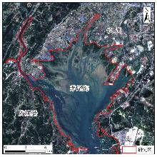
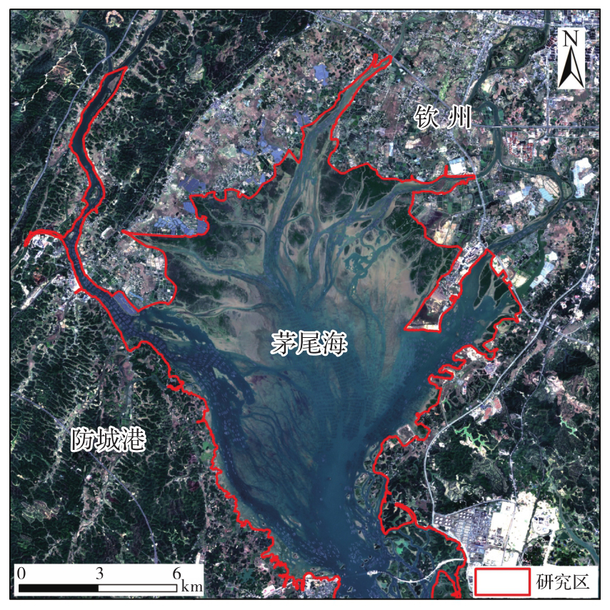
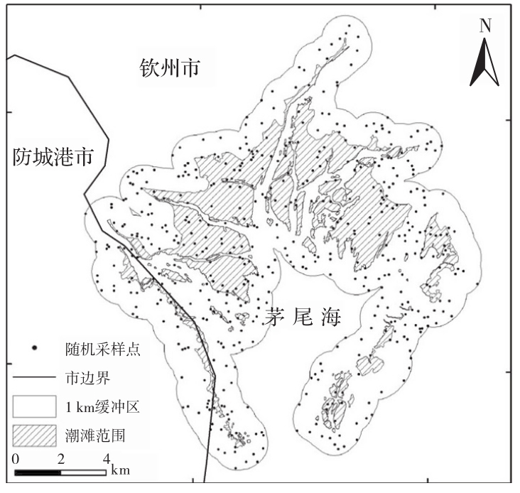
Fig. 1
Location of the study area"
Tab. 1
Sentinel-1/Sentinel-2 image acquisition information"
| 卫星 | 影像类型 | 获取年份 | 数量 | |
|---|---|---|---|---|
| Sentinel-1 | Sentinel-2 | |||
| Sentinel-1/Sentinel-2 | SAR/多光谱 | 2015 | 5 | 0 |
| 2016 | 8 | 7 | ||
| 2017 | 12 | 8 | ||
| 2018 | 12 | 14 | ||
| 2019 | 12 | 12 | ||
| 2020 | 12 | 13 | ||
| 2021 | 12 | 14 | ||
| 2022 | 11 | 17 | ||
| 2023 | 11 | 11 | ||
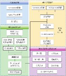
Fig. 2
Technical flow of this study"
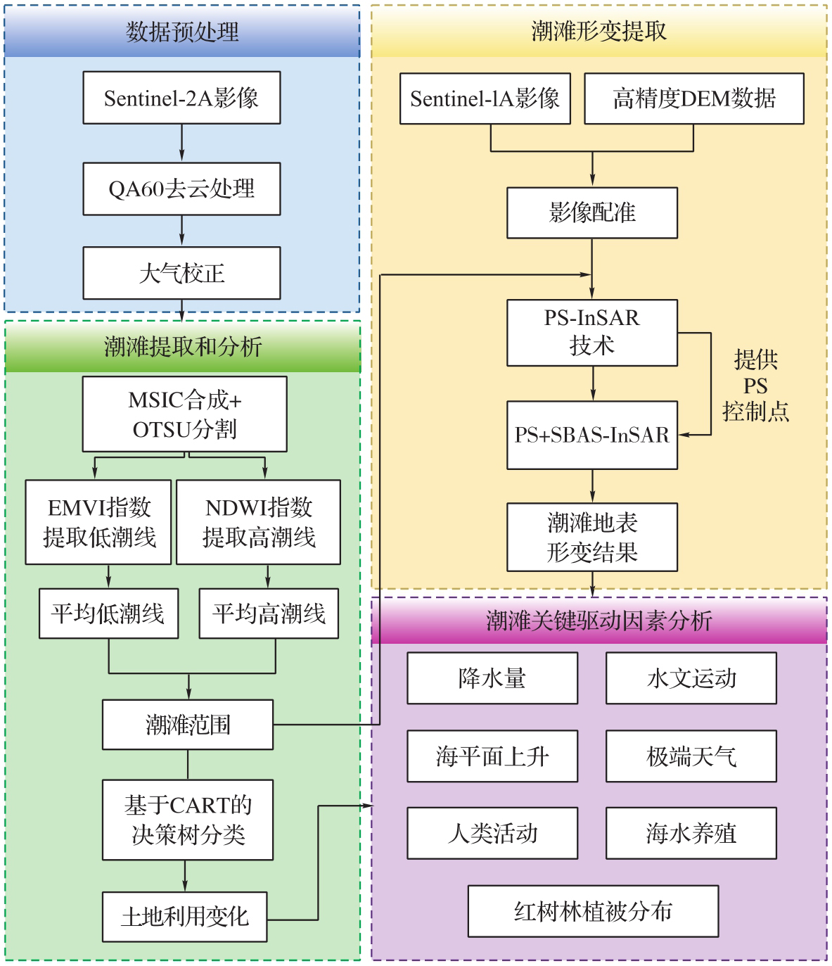
Fig. 3
Low tide results calculated by EMVI"

Fig. 4
Maximum synthetic image based on MSIC algorithm"
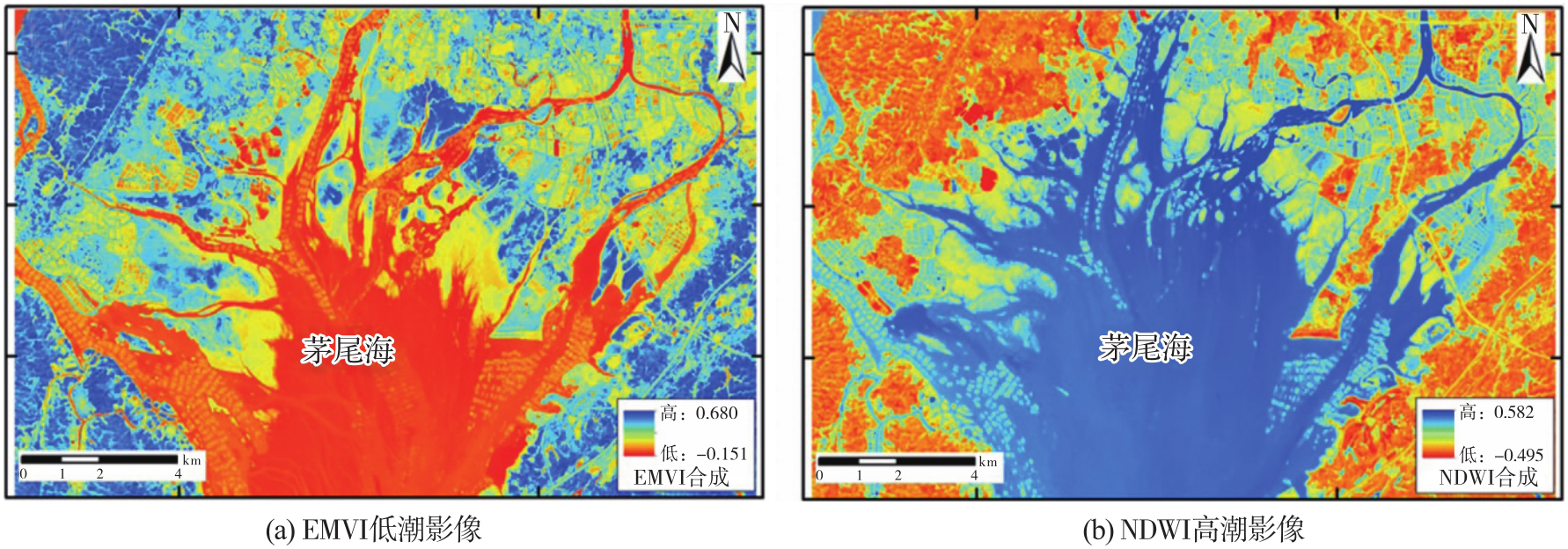
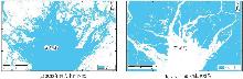
Fig. 5
Distribution of water bodies and land after binarization"
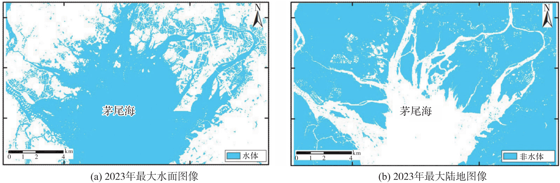
Fig. 6
Spatio-temporal baseline connectivity maps"
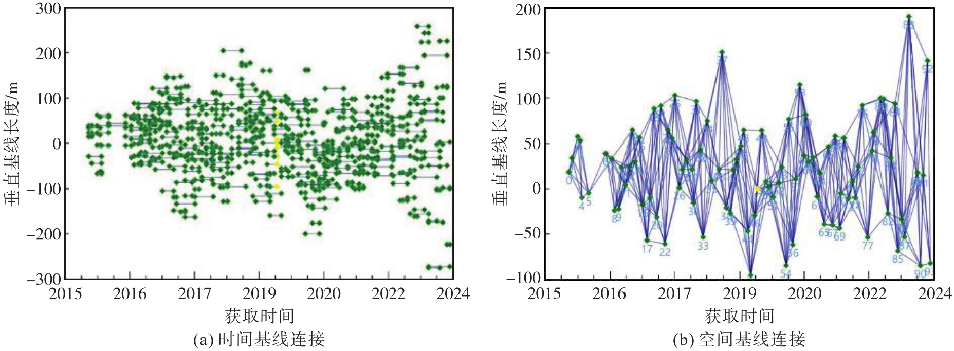
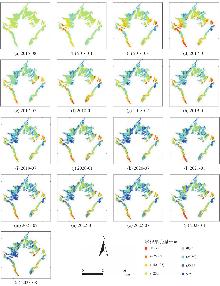
Fig. 7
Temporal deformation of tidal flats in Maowei Sea"
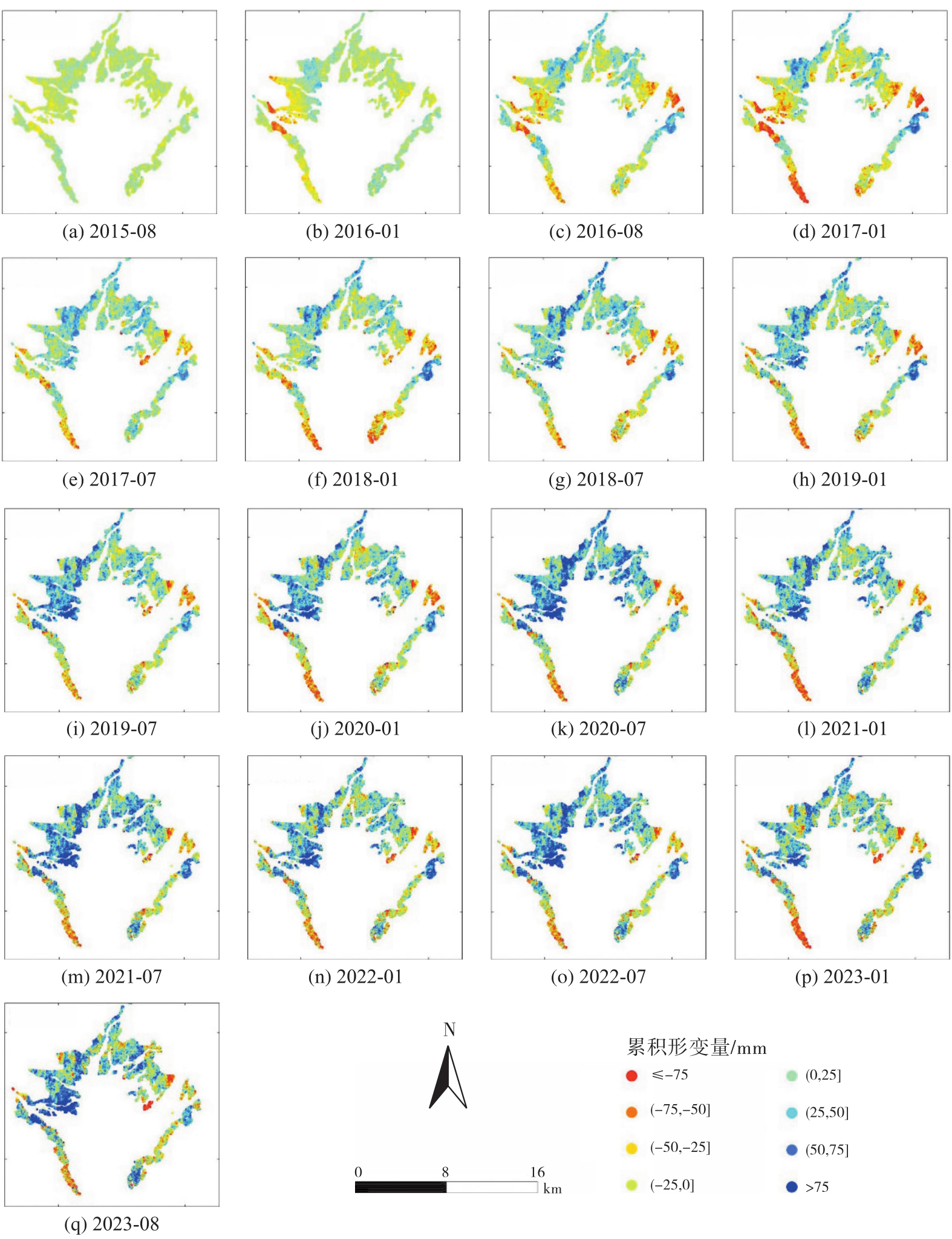
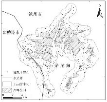
Fig. 8
Distribution of sampling points and buffers"
Tab. 2
Confusion matrix for evaluating the accuracy of tidal flats extraction"
| 提取类型 | 地物类别 | 用户精度 | ||
|---|---|---|---|---|
| 潮滩 | 其他 | 行总计 | ||
| 潮滩 | 143 | 6 | 149 | 95.97% |
| 其他 | 11 | 340 | 351 | 96.87% |
| 列总计 | 154 | 346 | 500 | — |
| 制图精度 | 92.86% | 98.27% | — | — |
| 总体分类精度:96.60% | Kappa系数:0.92 | |||
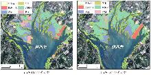
Fig. 9
Changes in tidal flats land use in the Maowei Sea"
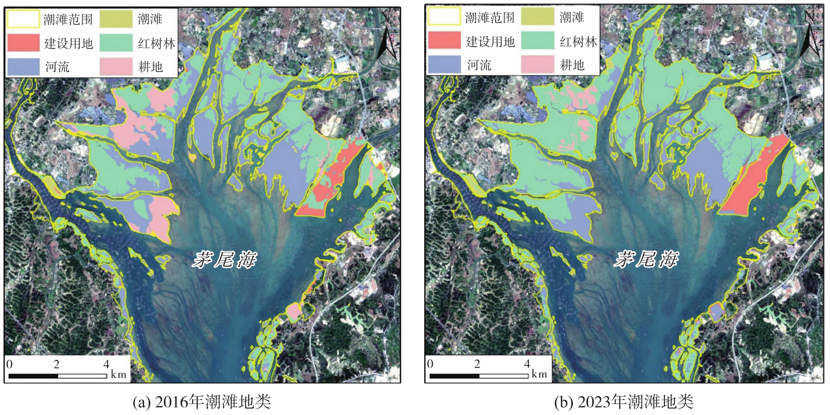
Fig. 10
Deformation results obtained by the PS+SBAS-InSAR technique"
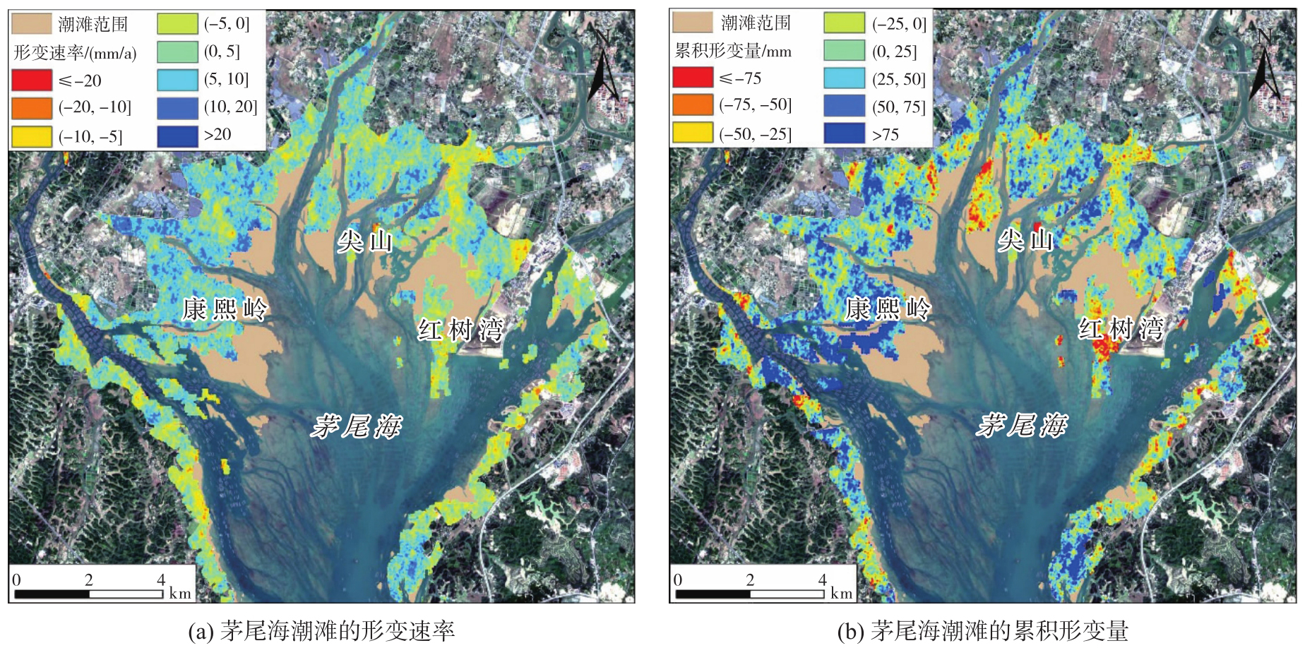
Fig. 11
Deformation results obtained by the PS-InSAR technique"
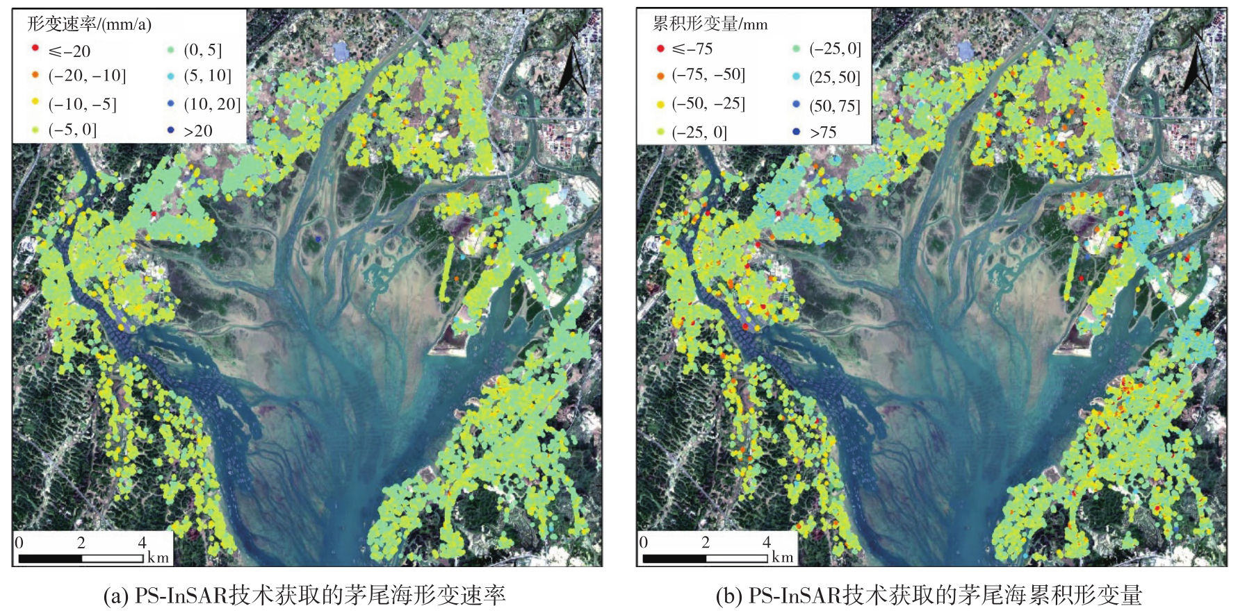
Tab. 3
Distribution statistics of deformation rate"
| 速率范围 | 相干点数量 | 所占比例/(%) |
|---|---|---|
| 速率≤-20 | 876 | 0.26 |
| -20<速率≤-10 | 16 929 | 4.98 |
| -10<速率≤-5 | 44 330 | 13.04 |
| -5<速率≤0 | 87 536 | 25.74 |
| 0<速率≤5 | 96 187 | 28.28 |
| 5<速率≤10 | 59 724 | 17.56 |
| 10<速率≤20 | 31 171 | 9.17 |
| 速率>20 | 3312 | 0.97 |
| 总计 | 340 065 | 100 |
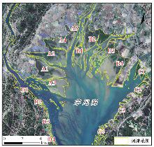
Fig. 12
Distribution of feature points in the study area"
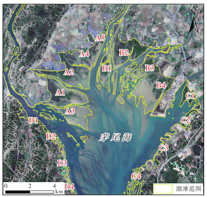

Fig. 13
Temporal deformation of characteristic points in each subregion of the study area"
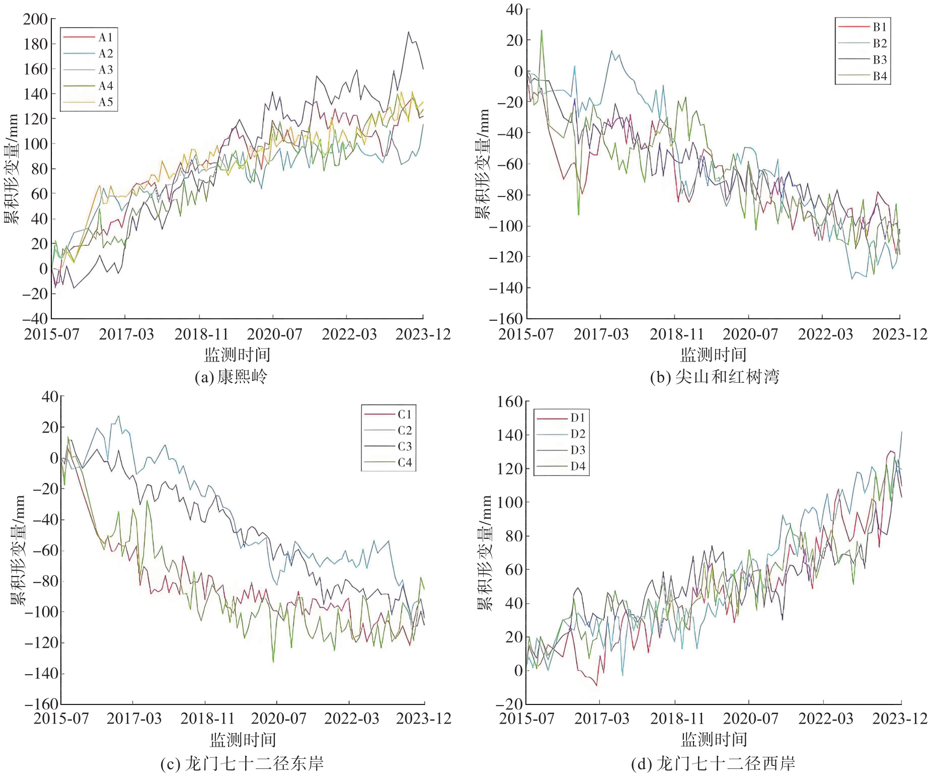
Fig. 14
Relationship between time-series deformation and precipitation at different feature points"
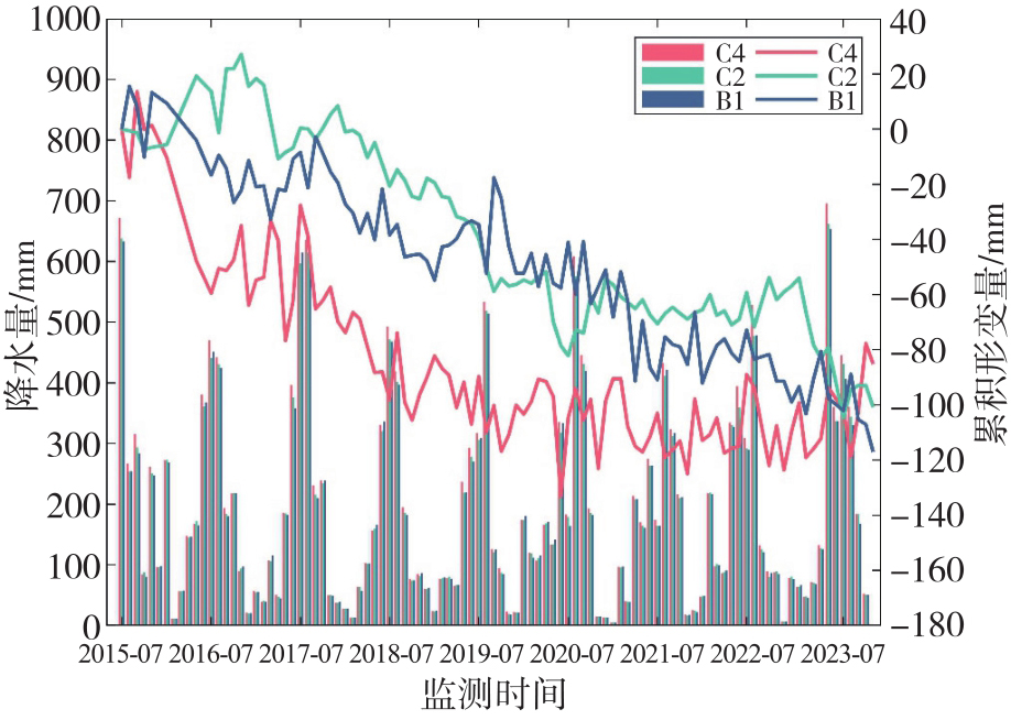
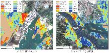
Fig. 15
Cumulative deformation of tidal flats in the estuaries of the Qinjiang and Maoling Rivers"
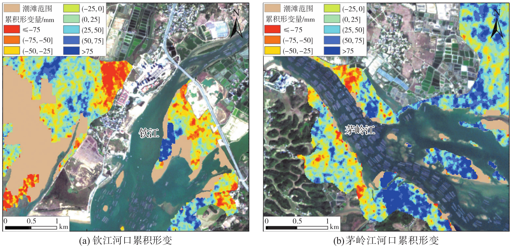
Fig. 16
Mean sea level change in the Beibu Gulf from 2015 to 2023"
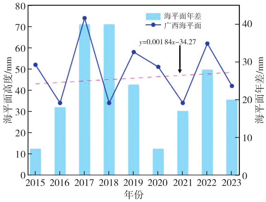
Fig. 17
Mean discharge and sediment load of the Qinjiang River under tropical cyclones and normal weather conditions"
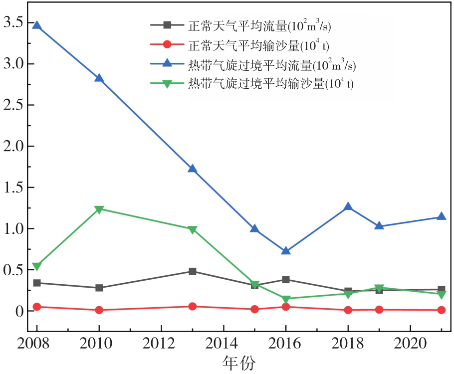
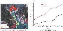
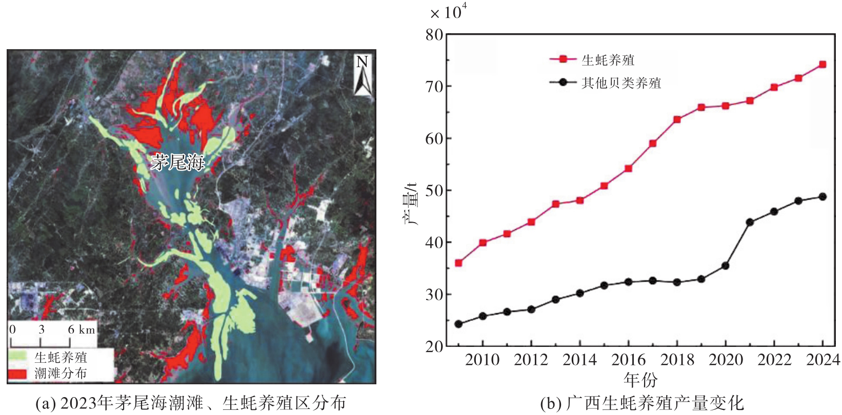
Fig. 18
Changes in oyster cultivation output in Guangxi from 2009 to 2024"
| [1] | HE Qiang, LI Zu'ang, DALEO P, et al. Coastal wetland resilience through local, regional and global conservation[J]. Nature Reviews Biodiversity, 2025, 1(1): 50-67. |
| [2] | GAO Ertao, ZHOU Guoqing, LI Shuxian, et al. Spatio-temporal evolution monitoring and analysis of tidal flats in Beibu Gulf from 1987 to 2021 using multisource remote sensing[J]. IEEE Journal of Selected Topics in Applied Earth Observations and Remote Sensing, 2024, 17: 6099-6114. |
| [3] | WU Wenting, ZHANG Min, CHEN Chunpeng, et al. Coastal reclamation shaped narrower and steeper tidal flats in Fujian, China: evidence from time-series satellite data[J]. Ocean & Coastal Management, 2024, 247: 106933. |
| [4] | TANG Pengfei, GUO Shanchuan, ZHANG Peng, et al. A highly efficient index for robust mapping of tidal flats from sentinel-2 images directly[J]. ISPRS Journal of Photogrammetry and Remote Sensing, 2024, 218: 742-760. |
| [5] | TSAI Y S, TSENG K H. Monitoring multidecadal coastline change and reconstructing tidal flat topography[J]. International Journal of Applied Earth Observation and Geoinformation, 2023, 118: 103260. |
| [6] |
邓开元, 任超. 多光谱光学遥感影像水体提取模型[J]. 测绘学报, 2021, 50(10): 1370-1379. DOI: .
doi: 10.11947/j.AGCS.2021.20200482 |
|
DENG Kaiyuan, REN Chao. Water extraction model of multispectral optical remote sensing image[J]. Acta Geodaetica et Cartographica Sinica, 2021, 50(10): 1370-1379. DOI: .
doi: 10.11947/j.AGCS.2021.20200482 |
|
| [7] | ZHANG Xuhui, ZUO Liqin, LU Yongjun, et al. An improved approach for retrieval of tidal flat elevation based on inundation frequency[J]. Estuarine, Coastal and Shelf Science, 2025, 313: 109061. |
| [8] | MURRAY N J, PHINN S R, DEWITT M, et al. The global distribution and trajectory of tidal flats[J]. Nature, 2019, 565(7738): 222-225. |
| [9] | GORELICK N, HANCHER M, DIXON M, et al. Google Earth Engine: planetary-scale geospatial analysis for everyone[J]. Remote Sensing of Environment, 2017, 202: 18-27. |
| [10] | MURRAY N J, PHINN S P, FULLER R A, et al. High-resolution global maps of tidal flat ecosystems from 1984 to 2019[J]. Scientific Data, 2022, 9: 542. |
| [11] | WANG Xinxin, XIAO Xiangming, ZOU Zhenhua, et al. Tracking annual changes of coastal tidal flats in China during 1986-2016 through analyses of Landsat images with Google Earth Engine[J]. Remote Sensing of Environment, 2020, 238: 110987. |
| [12] | JIA Mingming, WANG Zongming, MAO Dehua, et al. Rapid, robust, and automated mapping of tidal flats in China using time series Sentinel-2 images and Google Earth Engine[J]. Remote Sensing of Environment, 2021, 255: 112285. |
| [13] | 仇传银, 李行, 刘淑安, 等. 长江三角洲滩涂信息的遥感提取及时空变化[J]. 地球信息科学学报, 2019, 21(2): 269-278. |
| QIU Chuanyin, LI Xing, LIU Shu'an, et al. Monitoring tidal flats in the Yangtze River delta using landsat images[J]. Journal of Geo-Information Science, 2019, 21(2): 269-278. | |
| [14] |
王霞迎. InSAR在地表形变监测中的关键技术及应用[J]. 测绘学报, 2022, 51(10): 2244. DOI: .
doi: 10.11947/j.AGCS.2022.20220001 |
|
WANG Xiaying. Key techniques and their application of InSAR in ground deformation monitoring[J]. Acta Geodaetica et Cartographica Sinica, 2022, 51(10): 2244. DOI: .
doi: 10.11947/j.AGCS.2022.20220001 |
|
| [15] |
刘媛媛. 不同尺度综合地表形变InSAR时序监测与机理分析[J]. 测绘学报, 2020, 49(7): 935-935. DOI: .
doi: 10.11947/j.AGCS.2020.20190339 |
|
LIU Yuanyuan. Research on the monitoring and inversion of different-scale complex surface deformation with multi-temporal InSAR[J]. Acta Geodaetica et Cartographica Sinica, 2020, 49(7): 935-935. DOI: .
doi: 10.11947/j.AGCS.2020.20190339 |
|
| [16] | XIONG Jiacheng, HE Xiufeng, Alfred STEIN, et al. Deformation monitoring of the embankments using multi-temporal InSAR: a case study of the Kangshan embankment[J]. Journal of Geodesy and Geoinformation Science, 2025, 8(1): 12-29. |
| [17] | FERRETTI A, PRATI C, ROCCA F. Permanent scatterers in SAR interferometry[J]. IEEE Transactions on Geoscience and Remote Sensing, 2001, 39(1): 8-20. |
| [18] | BERARDINO P, FORNARO G, LANARI R, et al. A new algorithm for surface deformation monitoring based on small baseline differential SAR interferograms[J]. IEEE Transactions on Geoscience and Remote Sensing, 2002, 40(11): 2375-2383. |
| [19] |
朱建军, 李志伟, 胡俊. InSAR变形监测方法与研究进展[J]. 测绘学报, 2017, 46(10): 1717-1733. DOI: .
doi: 10.11947/j.AGCS.2017.20170350 |
|
ZHU Jianjun, LI Zhiwei, HU Jun. Research progress and methods of InSAR for deformation monitoring[J]. Acta Geodaetica et Cartographica Sinica, 2017, 46(10): 1717-1733. DOI: .
doi: 10.11947/j.AGCS.2017.20170350 |
|
| [20] | ZHOU LÜ, ZHAO Yizhan, ZHU Zilin, et al. Spatial and temporal evolution of surface subsidence in Tianjin from 2015 to 2020 based on SBAS-InSAR technology[J]. Journal of Geodesy and Geoinformation Science, 2022, 5(1): 60-72. |
| [21] | LIU Guang, PERSKI Z, SALVI S, et al. Land surface displacement geohazards monitoring using multi-temporal InSAR techniques[J]. Journal of Geodesy and Geoinformation Science, 2021, 4(1): 77-87. |
| [22] | 明小勇, 田义超, 张强, 等. 基于哨兵主被动遥感的茅尾海潮滩地表形变监测与分析[J]. 遥感学报, 2024, 28(9): 2306-2319. |
| MING Xiaoyong, TIAN Yichao, ZHANG Qiang, et al. Monitoring and analysis of surface deformation of tidal flat in Maowei Sea on the basis of Sentinel active and passive remote sensing[J]. National Remote Sensing Bulletin, 2024, 28(9): 2306-2319. | |
| [23] |
李鹏, 白建博, 李振洪, 等. 融合多轨道TS-InSAR的广域海岸带地面沉降监测及成因解析:以山东省为例[J]. 测绘学报, 2025, 54(7): 1178-1191. DOI: .
doi: 10.11947/j.AGCS.2025.20250061 |
|
LI Peng, BAI Jianbo, LI Zhenhong, et al. Wide area coastal subsidence monitoring and driver analysis with multi tracks of TS-InSAR: a case study of Shandong province[J]. Acta Geodaeticaet Cartographica Sinica, 2025, 54(7): 1178-1191. DOI: .
doi: 10.11947/j.AGCS.2025.20250061 |
|
| [24] | 朱武, 张勤, 丁晓利. 多参考点的PS-InSAR变形监测数据处理[J]. 测绘学报, 2012, 41(6): 886-890, 903. |
| ZHU Wu, ZHANG Qin, DING Xiaoli. PS-InSAR deformation monitoring data processing based on multi-reference points[J]. Acta Geodaetica et Cartographica Sinica, 2012, 41(6): 886-890, 903. | |
| [25] | YANG Gang, HUANG Ke, SUN Weiwei, et al. Enhanced mangrove vegetation index based on hyperspectral images for mapping mangrove[J]. ISPRS Journal of Photogrammetry and Remote Sensing, 2022, 189: 236-254. |
| [26] | TALUKDAR S, PAL S. Effects of damming on the hydrological regime of Punarbhaba river basin wetlands[J]. Ecological Engineering, 2019, 135: 61-74. |
| [27] | GAO Bocai. NDWI: a normalized difference water index for remote sensing of vegetation liquid water from space[J]. Remote Sensing of Environment, 1996, 58(3): 257-266. |
| [28] | 陆双龙. 月尺度下的茅尾海营养盐与环境因子的时空变化及空间自相关特征研究[D]. 南宁: 南宁师范大学, 2021. |
| LU Shuanglong. Spatiotemporal variation and spatial autocorrelation of nutrient and environmental factors in Maowei Sea at monthly scale[D]. Nanning: Nanning Normal University, 2021. | |
| [29] | 黎树式, 黄鹄. 近50年钦江水沙变化研究[J]. 广西科学, 2018, 25(4): 409-417. |
| LI Shushi, HUANG Hu. Variations of runoff and sediment in Qinjiang River in the past 50 years[J]. Guangxi Sciences, 2018, 25(4): 409-417. | |
| [30] | LEUVEN J R F W, PIERIK H J, VAN DER VEGT M, et al. Sea-level-rise-induced threats depend on the size of tide-influenced estuaries worldwide[J]. Nature Climate Change, 2019, 9(12): 986-992. |
| [31] | 罗新正, 孟宪伟. 基于相对海平面变化的广西茅尾海红树林面积稳定性评估[J]. 海洋环境科学, 2022, 41(6): 881-887. |
| LUO Xinzheng, MENG Xianwei. Assessment of mangrove area stability based on relative sea level change in Maowei Sea, Guangxi[J]. Marine Environmental Science, 2022, 41(6): 881-887. | |
| [32] | 许珊珊, 杨夏玲, 黎树式, 等. 北部湾钦江响应极端天气的水沙变化过程[J]. 热带地理, 2023, 43(11): 2135-2145. |
| XU Shanshan, YANG Xialing, LI Shushi, et al. Variations in the characteristics of water and sediment in response to extreme weather conditions in the Qinjiang River of the Beibu Gulf[J]. Tropical Geography, 2023, 43(11): 2135-2145. | |
| [33] | 江锐捷, 程鹏, 高建华, 等. 红树林对潮流底边界层动力过程的影响[J]. 海洋地质前沿, 2020, 36(4): 37-44. |
| JIANG Ruijie, CHENG Peng, GAO Jianhua, et al. Impacts of mangrove on the dynamic process of bottom boundary layer[J]. Marine Geology Frontiers, 2020, 36(4): 37-44. | |
| [34] | 王日明, 苏金恒, 戴志军, 等. 钦州湾茅岭江河口红树林湿地动态变化过程[J]. 热带海洋学报, 2025, 44(6): 143-154. |
| WANG Riming, SU Jinheng, DAI Zhijun, et al. Dynamic changes in mangrove wetland of the Maolingjiang Estuary, Qinzhou Gulf[J]. Journal of Tropical Oceanography, 2025, 44(6): 143-154. | |
| [35] | 焦海峰, 郑丹, 严巧娜, 等. 温度、盐度及交互作用对僧帽牡蛎(Saccostrea cucullata)呼吸排泄的影响[J]. 生态学报, 2017, 37(2): 692-699. |
| JIAO Haifeng, ZHENG Dan, YAN Qiaona, et al. Effects of water temperature and salinity on oxygen consumption rate and ammonia excretion rate of Saccostrea cucullata[J]. Acta Ecologica Sinica, 2017, 37(2): 692-699. |
| [1] | Peng LI, Jiahan ZHANG, Zhihan WANG, Houjie WANG, Zhenhong LI. A review of intertidal topography reconstruction methods: current status, challenges and trends [J]. Acta Geodaetica et Cartographica Sinica, 2026, 55(4): 571-587. |
| [2] | Lanxin WU, Jiangtao PENG, Weiwei SUN, Bing YANG. An Euler embedding and complementary feature modeling framework for hyperspectral change detection in coastal wetlands [J]. Acta Geodaetica et Cartographica Sinica, 2026, 55(4): 618-631. |
| [3] | Chenming YE, Zhizhong KANG, Jinhao CAI, Bingzheng ZUO, Shuai SHAO, Yan LI. A morphology-guided real-scene 3D modeling method of lunar geo-entities [J]. Acta Geodaetica et Cartographica Sinica, 2026, 55(3): 525-535. |
| [4] | Zhonghe LIU, Zongchun LI, Hua HE, Yinggang GUO, Wenbin ZHAO. A strategy for selecting quasi-stable points with a high breakdown point by integrating robust S-transform with K-means clustering [J]. Acta Geodaetica et Cartographica Sinica, 2025, 54(9): 1608-1619. |
| [5] | Shunping JI, Jin LIU, Jian GAO, Jianya GONG. An intelligent 3D reconstruction framework via deep learning based multi-view image matching [J]. Acta Geodaetica et Cartographica Sinica, 2025, 54(9): 1633-1646. |
| [6] | Kai YAN, Jianming XU, Qiao WANG. Earth surface anomaly detection based on lightweight large vision model features in remotely sensed imagery [J]. Acta Geodaetica et Cartographica Sinica, 2025, 54(9): 1664-1676. |
| [7] | Tianjun WU, Manjia LI, Jiancheng LUO, Ziqi LI, Xiaodong HU, Lijing GAO, Zhanfeng SHEN. Farmland-parcel-based crop remote sensing classification method in complex mountainous areas via coupling spatial distribution patterns [J]. Acta Geodaetica et Cartographica Sinica, 2025, 54(7): 1215-1229. |
| [8] | Yakun XIE, Yaoji ZHAO, Jiaxing TU, Ruifeng XIA, Dejun FENG, Suning LIU, Hongyu CHEN, Jun ZHU. Edge and global features integrated network for salient object detection in optical remote sensing images [J]. Acta Geodaetica et Cartographica Sinica, 2025, 54(7): 1265-1279. |
| [9] | Zibo DONG, Jingxue WANG, Lijing BU, Lin FANG, Zhenghui XU. MAFNet: building extraction method from remote sensing images based on multi-scale atrous fusion network [J]. Acta Geodaetica et Cartographica Sinica, 2025, 54(6): 1094-1106. |
| [10] | Haifeng LI, Wang GUO, Mengwei WU, Chengli PENG, Qing ZHU, Yu LIU, Chao TAO. Visual-language joint representation and intelligent interpretation of remote sensing geo-objects: principles, challenges and opportunities [J]. Acta Geodaetica et Cartographica Sinica, 2025, 54(5): 853-872. |
| [11] | Chao WANG, Tianyu CHEN, Tong ZHANG, Tanvir AHMED, Liqiang JI, Tao XIE, Jiajun YANG, Shuai WANG. Multi-sensor optical remote sensing images change detection based on global differential enhancement module and balance penalty loss [J]. Acta Geodaetica et Cartographica Sinica, 2025, 54(5): 873-887. |
| [12] | Yiming ZHAO, Kelin HU, Kelong TU, Yaxian QING, Chao YANG, Kunlun QI, Huayi WU. Multi-label scene classification method based on fusion of SAR and optical remote sensing images [J]. Acta Geodaetica et Cartographica Sinica, 2025, 54(5): 911-923. |
| [13] | Xinchang ZHANG, Ji QI, Chao TAO, Siyang FU, Mingning GUO, Yongjian RUAN. A survey on cloud removal in optical remote sensing images: progress, challenges, and future works [J]. Acta Geodaetica et Cartographica Sinica, 2025, 54(4): 603-620. |
| [14] | Bofeng LI, Long CHEN, Leitong YUAN. A high-precision deformation monitoring method with GNSS multi-baseline solutions [J]. Acta Geodaetica et Cartographica Sinica, 2025, 54(12): 2116-2128. |
| [15] | Xinrui LI, Xuanyu QU, Qin ZHANG, Bao SHU, Lingen MENG, Hao XU, Shuangcheng ZHANG, Guanwen HUANG, Hanwen WU, Li WANG. A data-driven multipath error mitigation method for PPP-RTK and its application in deformation monitoring [J]. Acta Geodaetica et Cartographica Sinica, 2025, 54(12): 2168-2181. |
| Viewed | ||||||
|
Full text |
|
|||||
|
Abstract |
|
|||||