

Acta Geodaetica et Cartographica Sinica ›› 2026, Vol. 55 ›› Issue (4): 571-587.doi: 10.11947/j.AGCS.2026.20260037
• Coastal and Marine Surveying, Mapping, and Remote Sensing • Next Articles
Peng LI1,2( ), Jiahan ZHANG1, Zhihan WANG1, Houjie WANG1,2, Zhenhong LI3()
Received:2026-01-26
Revised:2026-03-17
Online:2026-05-11
Published:2026-05-11
Contact:
Zhenhong LI
E-mail:pengli@ouc.edu.cn;zhenhong.li@chd.edu.cn
About author:LI Peng (1984—), male, PhD, associate professor, majors in coastal topographic surveying and deformation monitoring. E-mail: pengli@ouc.edu.cn
Supported by:CLC Number:
Peng LI, Jiahan ZHANG, Zhihan WANG, Houjie WANG, Zhenhong LI. A review of intertidal topography reconstruction methods: current status, challenges and trends[J]. Acta Geodaetica et Cartographica Sinica, 2026, 55(4): 571-587.
Fig. 1
Typical intertidal topographic monitoring platforms"
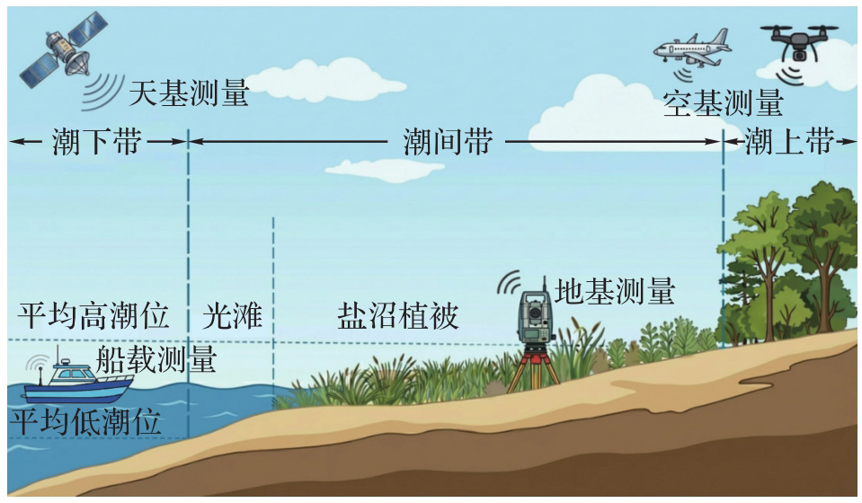
Fig. 2
Mainstrean global DEM data and its quality assessment: Yellow River Delta"
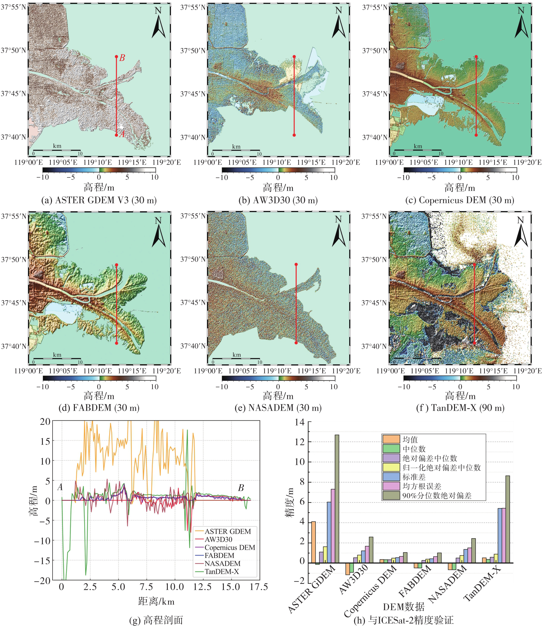
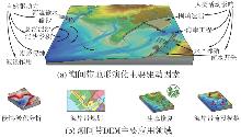
Fig. 3
Driving forces for intertidal geomorphological evolution and its typical applications"
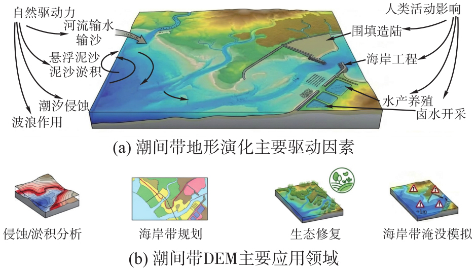
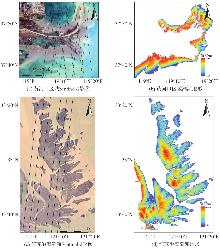
Fig. 4
Deep learning-driven thematic intertidal topography for the Yellow River Delta and the Jiangsu Radial Sand Ridges using multi-source data"

| [1] | 郑永飞, 郭正堂, 焦念志, 等. 地球系统科学研究态势[J]. 中国科学:地球科学, 2024, 54(10): 3065-3090. |
| ZHENG Yongfei, GUO zhengtang, JIAO Nianzhi, et al. A holistic perspective on Earth system science[J]. Scientia Sinica (Terrae), 2024, 54(10): 3065-3090. | |
| [2] | 陈吉余, 陈沈良. 中国河口海岸面临的挑战[J]. 海洋地质动态, 2002, 18(1): 1-5. |
| CHEN Jiyu, CHEN Shenliang. Estuarine and coastal challenges in China[J]. Marine Geology Letters, 2002, 18(1): 1-5. | |
| [3] | 骆永明. 中国海岸带可持续发展中的生态环境问题与海岸科学发展[J]. 中国科学院院刊, 2016, 31(10): 1133-1142. |
| LUO Yongming. Sustainability associated coastal eco-environmental problems and coastal science development in China[J]. Bulletin of the Chinese Academy of Sciences, 2016, 31(10): 1133-1142. | |
| [4] | 高抒, 贾建军, 于谦. 海岸冲淤动态的理论分析:物质收支、剖面形态、岸线进退[J]. 海洋地质与第四纪地质, 2023, 43(2): 1-17. |
| GAO Shu, JIA Jianjun, YU Qian. Theoretical framework for coastal accretion-erosion analysis: material budgeting, profile morphology, shoreline change[J]. Marine Geology & Quaternary Geology, 2023, 43(2): 1-17. | |
| [5] | MURRAY N J, PHINN S R, DEWITT M, et al. The global distribution and trajectory of tidal flats[J]. Nature, 2019, 565(7738): 222-225. |
| [6] | SCHUERCH M, SPENCER T, TEMMERMAN S, et al. Future response of global coastal wetlands to sea-level rise[J]. Nature, 2018, 561(7722): 231-234. |
| [7] | 李清泉, 卢艺, 胡水波, 等. 海岸带地理环境遥感监测综述[J]. 遥感学报, 2016, 20(5): 1216-1229. |
| LI Qingquan, LU Yi, HU Shuibo, et al. Review of remotely sensed geo-environmental monitoring of coastal zones[J]. Journal of Remote Sensing, 2016, 20(5): 1216-1229. | |
| [8] | LIU Shuai, HU Zhan, GRANDJEAN T J, et al. Dynamics and drivers of tidal flat morphology in China[J]. Nature Communications, 2025, 16: 2153. |
| [9] | ZHANG Zhen, XU Nan, LI Yangfan, et al. Sub-continental-scale mapping of tidal wetland composition for East Asia: a novel algorithm integrating satellite tide-level and phenological features[J]. Remote Sensing of Environment, 2022, 269: 112799. |
| [10] | BARBIER E B, HACKER S D, KENNEDY C, et al. The value of estuarine and coastal ecosystem services[J]. Ecological Monographs, 2011, 81(2): 169-193. |
| [11] | 朱庆, 张庆珩. 基于自适应分形内插的数字地面重建[J]. 北方交通大学学报, 1995(2): 159-164. |
| ZHU Qing, ZHANG Qingheng. The digital terrain reconstruction based on adaptive fractal interpolation[J]. Journal of Northern Jiaotong University, 1995(2): 159-164. | |
| [12] | ZHENG Yongjian. Digital photogrammetric inversion: theory and application to surface reconstruction[J]. Photogrammetric Engineering and Remote Sensing, 1993, 59(4): 489-498. |
| [13] | 李振洪, 李鹏, 丁咚, 等. 全球高分辨率数字高程模型研究进展与展望[J]. 武汉大学学报(信息科学版), 2018, 43(12): 1927-1942. |
| LI Zhenhong, LI Peng, DING Dong, et al. Research progress of global high resolution digital elevation models[J]. Geomatics and Information Science of Wuhan University, 2018, 43(12): 1927-1942. | |
| [14] | 孙伟伟, 陈超, 付波霖, 等. 海岸带遥感研究综述:进展、机遇和挑战[J]. 遥感学报, 2025, 29(11): 3136-3161. |
| SUN Weiwei, CHEN Chao, FU Bolin, et al. Review of coastal zone remote sensing research: development, opportunities and challenges[J]. National Remote Sensing Bulletin, 2025, 29(11): 3136-3161. | |
| [15] |
李鹏. 海岸带地理环境雷达遥感监测关键问题研究[J]. 测绘学报, 2021, 50(4): 565. DOI: .
doi: 10.11947/j.AGCS.2021.20200165 |
|
LI Peng. Key issues on coastal geographical environment monitoring with radar remote sensing[J]. Acta Geodaetica et Cartographica Sinica, 2021, 50(4): 565. DOI: .
doi: 10.11947/j.AGCS.2021.20200165 |
|
| [16] | 周曾, 陈雷, 林伟波, 等. 盐沼潮滩生物动力地貌演变研究进展[J]. 水科学进展, 2021, 32(3): 470-484. |
| ZHOU Zeng, CHEN Lei, LIN Weibo, et al. Advances in biogeomorphology of tidal flat-salt marsh systems[J]. Advances in Water Science, 2021, 32(3): 470-484. | |
| [17] | LI Peng, LI Zhenhong, DAI Keren, et al. Reconstruction and evaluation of DEMs from bistatic TanDEM-X SAR in mountainous and coastal areas of China[J]. IEEE Journal of Selected Topics in Applied Earth Observations and Remote Sensing, 2021, 14: 5152-5170. |
| [18] | 李鹏, 李振洪, 施闯, 等. 中国地区30 m分辨率SRTM质量评估[J]. 测绘通报, 2016(9): 24-28. |
| LI Peng, LI Zhenhong, SHI Chuang, et al. Quality evaluation of 1 arc second version SRTM DEM in China[J]. Bulletin of Surveying and Mapping, 2016(9): 24-28. | |
| [19] | MURRAY N J, WORTHINGTON T A, BUNTING P, et al. High-resolution mapping of losses and gains of Earth's tidal wetlands[J]. Science, 2022, 376(6594): 744-749. |
| [20] | XU Nan, GONG Peng. Significant coastline changes in China during 1991-2015 tracked by Landsat data[J]. Science Bulletin, 2018, 63(14): 883-886. |
| [21] | LEE J M, PARK J Y, CHOI J Y. Evaluation of sub-aerial topographic surveying techniques using total station and RTK-GPS for applications in macrotidal sand beach environment[J]. Journal of Coastal Research, 2013: 535-540. |
| [22] | LIPPMANN T C, HOLMAN R A. Quantification of sand bar morphology: a video technique based on wave dissipation[J]. Journal of Geophysical Research: Oceans, 1989, 94(C1): 995-1011. |
| [23] | AARNINKHOF S G J, TURNER I L, DRONKERS T D T, et al. A video-based technique for mapping intertidal beach bathymetry[J]. Coastal Engineering, 2003, 49(4): 275-289. |
| [24] | 郭云鹏, 陈玉军, 廖宝文, 等. 东寨港和淇澳岛红树林区地表高程和沉积层厚度变化的测量与研究[J]. 湿地科学, 2021, 19(3): 353-359. |
| GUO Yunpeng, CHEN Yujun, LIAO Baowen, et al. Measurement and study on variations of surface elevation and accretion thickness of areas of mangrove forests in Dongzhaigang bay and Qi'ao island[J]. Wetland Science, 2021, 19(3): 353-359. | |
| [25] | ELLENSON A N, SIMMONS J A, WILSON G W, et al. Beach state recognition using Argus imagery and convolutional neural networks[J]. Remote Sensing, 2020, 12(23): 3953. |
| [26] | HOLMAN R A, SYMONDS G, THORNTON E B, et al. Rip spacing and persistence on an embayed beach[J]. Journal of Geophysical Research: Oceans, 2006, 111(C1): 2005JC002965. |
| [27] | 时连强, 郭俊丽, 刘海江, 等. Argus系统在我国海滩研究中的应用进展与展望[J]. 地球科学进展, 2019, 34(5): 552-560. |
| SHI Lianqiang, GUO Junli, LIU Haijiang, et al. Application progress and prospect of Argus system in beach research in China[J]. Advances in Earth Science, 2019, 34(5): 552-560. | |
| [28] | MONTES J, DEL RíO L, PLOMARITIS T A, et al. Video-monitoring tools for assessing beach morphodynamics in tidal beaches[J]. Remote Sensing, 2023, 15(10): 2650. |
| [29] | GAO Wenli, SHEN Fang, TAN Kai, et al. Monitoring terrain elevation of intertidal wetlands by utilising the spatial-temporal fusion of multi-source satellite data: a case study in the Yangtze (Changjiang) Estuary[J]. Geomorphology, 2021, 383: 107683. |
| [30] | GUISADO-PINTADO E, JACKSON D W T, ROGERS D. 3D mapping efficacy of a drone and terrestrial laser scanner over a temperate beach-dune zone[J]. Geomorphology, 2019, 328: 157-172. |
| [31] | FABBRI S, GIAMBASTIANI B M S, SISTILLI F, et al. Geomorphological analysis and classification of foredune ridges based on terrestrial laser scanning (TLS) technology[J]. Geomorphology, 2017, 295: 436-451. |
| [32] | ANDRIOLO U, ALMEIDA L P, ALMAR R. Coupling terrestrial LiDAR and video imagery to perform 3D intertidal beach topography[J]. Coastal Engineering, 2018, 140: 232-239. |
| [33] | DONKER J, VAN MAARSEVEEN M, RUESSINK G. Spatio-temporal variations in foredune dynamics determined with mobile laser scanning[J]. Journal of Marine Science and Engineering, 2018, 6(4): 126. |
| [34] | CALLIGARO S, SOFIA G, PROSDOCIMI M, et al. Terrestrial laser scanner data to support coastal erosion analysis: the Conero case study[J]. The International Archives of the Photogrammetry, Remote Sensing and Spatial Information Sciences, 2014, XL-5/W3: 125-129. |
| [35] | BLENKINSOPP C E, MOLE M A, TURNER I L, et al. Measurements of the time-varying free-surface profile across the swash zone obtained using an industrial LiDAR[J]. Coastal Engineering, 2010, 57(11/12): 1059-1065. |
| [36] | VOUSDOUKAS M I, KIRUPAKARAMOORTHY T, OUMERACI H, et al. The role of combined laser scanning and video techniques in monitoring wave-by-wave swash zone processes[J]. Coastal Engineering, 2014, 83: 150-165. |
| [37] | TAN Kai, CHEN Jin, ZHANG Weiguo, et al. Estimation of soil surface water contents for intertidal mudflats using a near-infrared long-range terrestrial laser scanner[J]. ISPRS Journal of Photogrammetry and Remote Sensing, 2020, 159: 129-139. |
| [38] | MADRICARDO F, FOGLINI F, KRUSS A, et al. High resolution multibeam and hydrodynamic datasets of tidal channels and inlets of the Venice Lagoon[J]. Scientific Data, 2017, 4: 170121. |
| [39] | JANOWSKI L, TRZCINSKA K, TEGOWSKI J, et al. Nearshore benthic habitat mapping based on multi-frequency, multibeam echosounder data using a combined object-based approach: a case study from the Rowy site in the southern Baltic Sea[J]. Remote Sensing, 2018, 10(12): 1983. |
| [40] | 李勇航, 单晨晨, 苏明, 等. 声学水面无人艇在浅水海底地貌调查中的应用[J]. 海洋地质与第四纪地质, 2020, 40(6): 219-226. |
| LI Yonghang, SHAN Chenchen, SU Ming, et al. Application of acoustic unmanned surface vehicle to submarine geomorphology survey in shallow water[J]. Marine Geology & Quaternary Geology, 2020, 40(6): 219-226. | |
| [41] | 朱晓武, 王斌, 刘金沧, 等. 联合船载单波束潮间带机载LiDAR测量系统[J]. 测绘通报, 2023(2): 145-149. |
| ZHU Xiaowu, WANG Bin, LIU Jincang, et al. Intertidal zone measurement combined shipborne single beam bathymetry with airborne LiDAR system[J]. Bulletin of Surveying and Mapping, 2023(2): 145-149. | |
| [42] | WESTOBY M J, BRASINGTON J, GLASSER N F, et al. ‘Structure-from-motion’ photogrammetry: a low-cost, effective tool for geoscience applications[J]. Geomorphology, 2012, 179: 300-314. |
| [43] | FONSTAD M A, DIETRICH J T, COURVILLE B C, et al. Topographic structure from motion: a new development in photogrammetric measurement[J]. Earth Surface Processes and Landforms, 2013, 38(4): 421-430. |
| [44] | LONG N, MILLESCAMPS B, GUILLOT B, et al. Monitoring the topography of a dynamic tidal inlet using UAV imagery[J]. Remote Sensing, 2016, 8(5): 387. |
| [45] | STURDIVANT E J, LENTZ E E, THIELER E R, et al. UAS-SfM for coastal research: geomorphic feature extraction and land cover classification from high-resolution elevation and optical imagery[J]. Remote Sensing, 2017, 9(10): 1020. |
| [46] | CHEN Chunpeng, ZHANG Ce, SCHWARZ C, et al. Mapping three-dimensional morphological characteristics of tidal salt-marsh channels using UAV structure-from-motion photogrammetry[J]. Geomorphology, 2022, 407: 108235. |
| [47] | LEE H, KIM D J. Generation of dense and high-precision digital elevation model using low-cost unmanned aerial vehicle and space-borne TanDEM-X to measure exposed area change due to tidal invasion[J]. IEEE Journal of Selected Topics in Applied Earth Observations and Remote Sensing, 2022, 15: 6899-6911. |
| [48] | KALACSKA M, CHMURA G L, LUCANUS O, et al. Structure from motion will revolutionize analyses of tidal wetland landscapes[J]. Remote Sensing of Environment, 2017, 199: 14-24. |
| [49] | NIELSEN M S, NIKOLOV I, KRUSE E K, et al. Quantifying the influence of surface texture and shape on structure from motion 3D reconstructions[J]. Sensors, 2023, 23(1): 178. |
| [50] | VOUMARD J, DERRON M H, JABOYEDOFF M, et al. Pros and cons of structure for motion embarked on a vehicle to survey slopes along transportation lines using 3D georeferenced and coloured point clouds[J]. Remote Sensing, 2018, 10(11): 1732. |
| [51] | DENKA DURGAN S, ZHANG Caiyun, DUECASTER A. Evaluation and enhancement of unmanned aircraft system photogrammetric data quality for coastal wetlands[J]. GIScience & Remote Sensing, 2020, 57(7): 865-881. |
| [52] | CURCIO A C, PERALTA G, ARANDA M, et al. Evaluating the performance of high spatial resolution UAV-photogrammetry and UAV-LiDAR for salt marshes: the Cádiz Bay study case[J]. Remote Sensing, 2022, 14(15): 3582. |
| [53] | MORGAN G R, HODGSON M E, WANG Cuizhen, et al. Unmanned aerial remote sensing of coastal vegetation: a review[J]. Annals of GIS, 2022, 28(3): 385-399. |
| [54] | PINTON D, CANESTRELLI A, WILKINSON B, et al. A new algorithm for estimating ground elevation and vegetation characteristics in coastal salt marshes from high-resolution UAV-based LiDAR point clouds[J]. Earth Surface Processes and Landforms, 2020, 45(14): 3687-3701. |
| [55] | WU Xixiu, TAN Kai, LIU Shuai, et al. Drone multiline light detection and ranging data filtering in coastal salt marshes using extreme gradient boosting model[J]. Drones, 2024, 8(1): 13. |
| [56] | BRUNETTA R, DUO E, CIAVOLA P. Evaluating short-term tidal flat evolution through UAV surveys: a case study in the Po Delta (Italy)[J]. Remote Sensing, 2021, 13(12): 2322. |
| [57] | ZHANG Haifeng, WANG Lian, ZHAO Yifei, et al. Application of airborne LiDAR measurements to the topographic survey of the tidal flats of the northern Jiangsu radial sand ridges in the southern Yellow Sea[J]. Frontiers in Marine Science, 2022, 9: 871156. |
| [58] | DENG Longbo, HUANG Liping, QI Yali, et al. A preliminary study on the impact of high-level pond tailwater discharge on beach topography: based on unmanned aerial vehicle LiDAR measurement data[J]. Anthropocene Coasts, 2025, 8(1): 29. |
| [59] | MADER D, RICHTER K, WESTFELD P, et al. Volumetric nonlinear ortho full-waveform stacking in airborne LiDAR bathymetry for reliable water bottom point detection in shallow waters[J]. ISPRS Journal of Photogrammetry and Remote Sensing, 2023, 204: 145-162. |
| [60] | FERNANDEZ-NUNEZ M, BURNINGHAM H, OJEDA ZUJAR J. Improving accuracy of LiDAR-derived digital terrain models for salt marsh management[J]. Journal of Coastal Conservation, 2017, 21(1): 209-222. |
| [61] | AMANTE C J. Estimating coastal digital elevation model uncertainty[J]. Journal of Coastal Research, 2018, 34(6): 1382-1397. |
| [62] | YAO Huang, QIN Rongjun, CHEN Xiaoyu. Unmanned aerial vehicle for remote sensing applications: a review[J]. Remote Sensing, 2019, 11(12): 1443. |
| [63] |
唐新明, 王鸿燕. 我国民用光学卫星测绘产品体系的建立与应用[J]. 测绘学报, 2022, 51(7): 1386-1397. DOI: .
doi: 10.11947/j.AGCS.2022.20220181 |
|
TANG Xinming, WANG Hongyan. Establishment and application of China civil optical satellite surveying and mapping products[J]. Acta Geodaetica et Cartographica Sinica, 2022, 51(7): 1386-1397. DOI: .
doi: 10.11947/j.AGCS.2022.20220181 |
|
| [64] | JAMES D, COLLIN A, MURY A, et al. Satellite-derived topography and morphometry for VHR coastal habitat mapping: the Pleiades-1 tri-stereo enhancement[J]. Remote Sensing, 2022, 14(1): 219. |
| [65] | ALMEIDA L P, ALMAR R, BERGSMA E W J, et al. Deriving high spatial-resolution coastal topography from sub-meter satellite stereo imagery[J]. Remote Sensing, 2019, 11(5): 590. |
| [66] | ALMAR R, BERGSMA E W J, BRODIE K L, et al. Coastal topo-bathymetry from a single-pass satellite video: insights in space-videos for coastal monitoring at Duck beach (NC, USA)[J]. Remote Sensing, 2022, 14(7): 1529. |
| [67] | BERGSMA E W J, ALMAR R, ROLLAND A, et al. Coastal morphology from space: a showcase of monitoring the topography-bathymetry continuum[J]. Remote Sensing of Environment, 2021, 261: 112469. |
| [68] | LETORTU P, JAUD M, THÉRY C, et al. The potential of Pléiades images with high angle of incidence for reconstructing the coastal cliff face in Normandy (France)[J]. International Journal of Applied Earth Observation and Geoinformation, 2020, 84: 101976. |
| [69] | SALAMEH E, FRAPPART F, ALMAR R, et al. Monitoring beach topography and nearshore bathymetry using spaceborne remote sensing: a review[J]. Remote Sensing, 2019, 11(19): 2212. |
| [70] | BHUSHAN S, SHEAN D, ALEXANDROV O, et al. Automated digital elevation model (DEM) generation from very-high-resolution Planet SkySat triplet stereo and video imagery[J]. ISPRS Journal of Photogrammetry and Remote Sensing, 2021, 173: 151-165. |
| [71] | LI Peng, WANG Guoyang, LIANG Cunren, et al. InSAR-derived coastal subsidence reveals new inundation scenarios over the Yellow River Delta[J]. IEEE Journal of Selected Topics in Applied Earth Observations and Remote Sensing, 2023, 16: 8431-8441. |
| [72] | WANG Guoyang, LI Peng, LI Zhenhong, et al. Coastal subsidence detection and characterization caused by brine mining over the Yellow River Delta using time series InSAR and PCA[J]. International Journal of Applied Earth Observation and Geoinformation, 2022, 114: 103077. |
| [73] | LEE S K, RYU J H. High-accuracy tidal flat digital elevation model construction using TanDEM-X science phase data[J]. IEEE Journal of Selected Topics in Applied Earth Observations and Remote Sensing, 2017, 10(6): 2713-2724. |
| [74] | CHOI C, KIM D J. Optimum baseline of a single-pass In-SAR system to generate the best DEM in tidal flats[J]. IEEE Journal of Selected Topics in Applied Earth Observations and Remote Sensing, 2018, 11(3): 919-929. |
| [75] | LEE J Y, HONG S H. Construction of digital elevation models on the intertidal flats using TanDEM-X bistatic observations[J]. IEEE Geoscience and Remote Sensing Letters, 2024, 21: 4005805. |
| [76] | KIM K, JUNG H C, CHOI J K, et al. Statistical analysis for tidal flat classification and topography using multitemporal SAR backscattering coefficients[J]. Remote Sensing, 2021, 13(24): 5169. |
| [77] | GADE M, ALPERS W, MELSHEIMER C, et al. Classification of sediments on exposed tidal flats in the German Bight using multi-frequency radar data[J]. Remote Sensing of Environment, 2008, 112(4): 1603-1613. |
| [78] | XU Hao, XU Nan, LI Wenyu, et al. A large-scale framework for deriving tidal flat topography from SWOT data[J]. Remote Sensing of Environment, 2026, 334: 115237. |
| [79] | SALAMEH E, DESROCHES D, DELOFFRE J, et al. Evaluating SWOT's interferometric capabilities for mapping intertidal topography[J]. Remote Sensing of Environment, 2024, 314: 114401. |
| [80] |
唐新明, 谢俊峰, 莫凡, 等. 高分七号卫星双波束激光测高仪在轨几何检校与试验验证[J]. 测绘学报, 2021, 50(3): 384-395. DOI: .
doi: 10.11947/j.AGCS.2021.20200397 |
|
TANG Xinming, XIE Junfeng, MO Fan, et al. GF-7 dual-beam laser altimeter on-orbit geometric calibration and test verification[J]. Acta Geodaetica et Cartographica Sinica, 2021, 50(3): 384-395. DOI: .
doi: 10.11947/j.AGCS.2021.20200397 |
|
| [81] | YAO Jiaqi, MO Fan, XU Nan, et al. The Chinese laser altimetry satellite will significantly enhance the 3D mapping capability of global coastal zones[J]. The Innovation Geoscience, 2025, 3(1): 100121. |
| [82] | 张鹰, 张东, 胡平香. 海岸带潮滩土壤含水量遥感测量[J]. 海洋学报, 2008, 30(5): 29-34. |
| ZHANG Ying, ZHANG Dong, HU Pingxiang. Water content of soil on outcrop beach measured by remote sensing[J]. Haiyang Xuebao, 2008, 30(5): 29-34. | |
| [83] | LI Huan, CUTLER M, ZHANG Dong, et al. Retrieval of tidal flat elevation based on remotely sensed moisture approach[J]. IEEE Journal of Selected Topics in Applied Earth Observations and Remote Sensing, 2022, 15: 5357-5370. |
| [84] | MASON D C, DAVENPORT I J, ROBINSON G J, et al. Construction of an inter-tidal digital elevation model by the ‘water-line’ method[J]. Geophysical Research Letters, 1995, 22(23): 3187-3190. |
| [85] | HEYGSTER G, DANNENBERG J, NOTHOLT J. Topographic mapping of the German tidal flats analyzing SAR images with the waterline method[J]. IEEE Transactions on Geoscience and Remote Sensing, 2010, 48(3): 1019-1030. |
| [86] | MASON D C, DAVENPORT I J, FLATHER R A. Interpolation of an intertidal digital elevation model from heighted shorelines: a case study in the Western Wash[J]. Estuarine, Coastal and Shelf Science, 1997, 45(5): 599-612. |
| [87] | ZHANG Shuangshang, XU Qing, WANG Haoyu, et al. Automatic waterline extraction and topographic mapping of tidal flats from SAR images based on deep learning[J]. Geophysical Research Letters, 2022, 49(2): e2021GL096007. |
| [88] | CHEN Chunpeng, ZHANG Ce, TIAN Bo, et al. Mapping intertidal topographic changes in a highly turbid estuary using dense Sentinel-2 time series with deep learning[J]. ISPRS Journal of Photogrammetry and Remote Sensing, 2023, 205: 1-16. |
| [89] | SALAMEH E, FRAPPART F, TURKI I, et al. Intertidal topography mapping using the waterline method from Sentinel-1 & -2 images: the examples of Arcachon and Veys Bays in France[J]. ISPRS Journal of Photogrammetry and Remote Sensing, 2020, 163: 98-120. |
| [90] | XU Nan, WANG Lin, MA Yue, et al. Constructing intertidal topography for sandy beaches by combining Sentinel-2 imagery and water level data[J]. Geo-spatial Information Science, 2025, 28(5): 2400-2414. |
| [91] | CAO Jicheng, LIU Qing, YU Chengfeng, et al. Extracting waterline and inverting tidal flats topography based on Sentinel-2 remote sensing images: a case study of the northern part of the North Jiangsu radial sand ridges[J]. Geomorphology, 2024, 461: 109323. |
| [92] | LI Chenglei, KIM D J, AN S, et al. An enhanced tidal flat waterline extraction algorithm based on curated Sentinel-2 training data and its applications[J]. IEEE Journal of Selected Topics in Applied Earth Observations and Remote Sensing, 2025, 18: 27430-27452. |
| [93] | XU Nan, MA Yue, YANG Jian, et al. Deriving tidal flat topography using ICESat-2 laser altimetry and Sentinel-2 imagery[J]. Geophysical Research Letters, 2022, 49(2): e2021GL096813. |
| [94] | ZHENG Xiucheng, ZHOU Bin, LEI Hui, et al. Mapping tidal flat topography using time-series Sentinel-2 images and ICESat-2 data: a case study in Cixi city[J]. Ocean & Coastal Management, 2024, 256: 107278. |
| [95] | CHEN Chunpeng, ZHANG Ce, TIAN Bo, et al. Tide2Topo: a new method for mapping intertidal topography accurately in complex estuaries and bays with time-series Sentinel-2 images[J]. ISPRS Journal of Photogrammetry and Remote Sensing, 2023, 200: 55-72. |
| [96] | MING Xiaoyong, TIAN Yichao, ZHANG Qiang, et al. Coupling ICESat-2 and Sentinel-2 data for inversion of mangrove tidal flat to predict future distribution pattern of mangroves[J]. International Journal of Applied Earth Observation and Geoinformation, 2025, 136: 104398. |
| [97] | ZHANG Zhaoyuan, ZHANG Huaguo, CAO Wenting, et al. Inundation frequency correction method for mapping multi-temporal tidal flat topography integrating Sentinel-1 and ICESat-2 data[J/OL]. Geo-spatial Information Science. [2025-12-12]. http://doi.org/10.1080/10095020.2025.2539951. |
| [98] | ZHANG Xuhui, ZUO Liqin, LU Yongjun, et al. An improved approach for retrieval of tidal flat elevation based on inundation frequency[J]. Estuarine, Coastal and Shelf Science, 2025, 313: 109061. |
| [99] | XIN Huichao, XU Nan, XU Hao, et al. Mapping tidal flat topography by combining ICESat-2 laser altimetry and multi-source satellite imagery[J]. International Journal of Digital Earth, 2025, 18(2): 2554313. |
| [100] | TANG Pengfei, GUO Shanchuan, QIE Lu, et al. Tidal flat topography mapping with Sentinel time series using cross-modal sample transfer and deep learning[J]. ISPRS Journal of Photogrammetry and Remote Sensing, 2025, 225: 69-87. |
| [101] | SIMARD M, DENBINA M, MARSHAK C, et al. A global evaluation of radar-derived digital elevation models: SRTM, NASADEM, and GLO-30[J]. Journal of Geophysical Research: Biogeosciences, 2024, 129(11): e2023JG007672. |
| [102] | YAMAZAKI D, IKESHIMA D, TAWATARI R, et al. A high-accuracy map of global terrain elevations[J]. Geophysical Research Letters, 2017, 44(11): 5844-5853. |
| [103] | PRONK M, HOOIJER A, EILANDER D, et al. DeltaDTM: a global coastal digital terrain model[J]. Scientific Data, 2024, 11: 273. |
| [104] | HAWKER L, UHE P, PAULO L, et al. A 30 m global map of elevation with forests and buildings removed[J]. Environmental Research Letters, 2022, 17(2): 024016. |
| [105] | DUSSEAU D, ZOBEL Z, SCHWALM C R. DiluviumDEM: enhanced accuracy in global coastal digital elevation models[J]. Remote Sensing of Environment, 2023, 298: 113812. |
| [106] | GESCH D B. Assessing global elevation models for mapping the low elevation coastal zone[C]//Proceedings of 2023 Geomorphometry. Romania: Tehnopress, 2023. |
| [107] | MEADOWS M, JONES S, REINKE K. Vertical accuracy assessment of freely available global DEMs (FABDEM, copernicus DEM, NASADEM, AW3D30 and SRTM) in flood-prone environments[J]. International Journal of Digital Earth, 2024, 17(1): 2308734. |
| [108] | DING Hu, LIU Junhao, YANG Sihang, et al. Performance assessment of global open-access digital elevation models in China mainland coastal region[J]. Earth Surface Processes and Landforms, 2023, 48(11): 2133-2140. |
| [109] | SHIH S S, HSU W C, HSU Y W. Waterline digital elevation model development to quantify inundation duration and coastal protection of tidal wetlands[J]. Science of the Total Environment, 2023, 874: 162519. |
| [110] | CROWELL N, WEBSTER T, O'DRISCOLL N J. GIS modelling of intertidal wetland exposure characteristics[J]. Journal of Coastal Research, 2011, 27(6A): 44-51. |
| [111] | CURCIO A C, BARBERO L, PERALTA G. Enhancing salt marshes monitoring: estimating biomass with drone-derived habitat-specific models[J]. Remote Sensing Applications: Society and Environment, 2024, 35: 101216. |
| [112] | KANG Yanyan, LEI Jun, WANG Minjing, et al. Topographic evolution of tidal flats based on remote sensing: an example in Jiangsu coast, Southern Yellow Sea[J]. Frontiers in Marine Science, 2023, 10: 1163302. |
| [113] | DAI Weiqi, LI Huan, ZHOU Zeng, et al. UAV photogrammetry for elevation monitoring of intertidal mudflats[J]. Journal of Coastal Research, 2018, 85: 236-240. |
| [114] | GESCH D B. Best practices for elevation-based assessments of sea-level rise and coastal flooding exposure[J]. Frontiers in Earth Science, 2018, 6: 230. |
| [115] | THATCHER C A, BROCK J C, DANIELSON J J, et al. Creating a coastal national elevation database (CoNED) for science and conservation applications[J]. Journal of Coastal Research, 2016, 76: 64-74. |
| [116] | GESCH D B. Consideration of vertical uncertainty in elevation-based sea-level rise assessments: mobile bay, Alabama case study[J]. Journal of Coastal Research, 2013, 63: 197-210. |
| [117] | FERESHTEHPOUR M, KARAMOUZ M. DEM resolution effects on coastal flood vulnerability assessment: deterministic and probabilistic approach[J]. Water Resources Research, 2018, 54(7): 4965-4982. |
| [118] | AVAND M, KURIQI A, KHAZAEI M, et al. DEM resolution effects on machine learning performance for flood probability mapping[J]. Journal of Hydro-Environment Research, 2022, 40: 1-16. |
| [1] | Hao XU, Nan XU, Huichao XIN, Yue MA, Wei TU, Qingquan LI. A topographic photon extraction method for intertidal zones using ICESat-2 satellite altimeter data [J]. Acta Geodaetica et Cartographica Sinica, 2026, 55(4): 658-672. |
| [2] | Jiayao WANG, Lin CHEN, Shiyuan CHENG, Lijun WANG, Siqi XIONG. Artificial intelligence empowering the digital-intelligent transformation of cartographic science [J]. Acta Geodaetica et Cartographica Sinica, 2026, 55(3): 381-389. |
| [3] | Wentao HOU, Yun XIAO, Jie CAO, Yukang WANG, Chunting CAO, Han WANG. A downscaling method for gravity satellite derived groundwater storage changes based on a feature-weighted CatBoost model [J]. Acta Geodaetica et Cartographica Sinica, 2026, 55(3): 490-501. |
| [4] | Shaohua WANG, Haojian LIANG, Cheng SU, Dachuan XU, Liang ZHOU, Kun QIN. Advances and prospects in urban facility allocation optimization through coupling spatio-temporal big data and artificial intelligence [J]. Acta Geodaetica et Cartographica Sinica, 2026, 55(2): 222-235. |
| [5] | Zhaofeng DU, Guopeng LI, Zhanke LIU, Xiaming SHANG, Shengjun KANG, Xiaoqiang WANG. Comprehensive analysis of multiple monitoring methods in main subsidence areas [J]. Acta Geodaetica et Cartographica Sinica, 2025, 54(3): 481-492. |
| [6] | Xiaohu LIN, Xin YANG, Wanqiang YAO, Hongwei MA, Bolin MA, Xiongwei MA. A dynamic weighted fusion SLAM method using multi-source sensor data in complex underground spaces [J]. Acta Geodaetica et Cartographica Sinica, 2025, 54(3): 523-535. |
| [7] | Xiaohua TONG, Rong HUANG, Jiarui CAO, Chen LIU, Rong WANG, Yusheng XU, Zhen YE, Yanmin JIN, Shijie LIU, Sicong LIU, Yongjiu FENG, Huan XIE. Intelligent methods for 3D terrain reconstruction of the Moon and near-Earth planets: a review of current advances and future perspectives [J]. Acta Geodaetica et Cartographica Sinica, 2025, 54(11): 1917-1933. |
| [8] | Jichao LÜ, Rui ZHANG, Xu HE, Ruikai HONG, Age SHAMA, Guoxiang LIU. Multi-branch network assessment and dynamic change analysis of wide-area landslide susceptibility [J]. Acta Geodaetica et Cartographica Sinica, 2025, 54(1): 104-122. |
| [9] | Dongxu LIU, Litang HU, Jianchong SUN, Qi CHENG, Yixuan MA, Xin LIU. Retrieval of groundwater storage anomalies in eastern region of Korla by downscaling GRACE/GRACE-FO data [J]. Acta Geodaetica et Cartographica Sinica, 2024, 53(7): 1265-1277. |
| [10] | Xiaogang NING, Hanchao ZHANG, Ruiqian ZHANG. Practical framework and methodology for high-performance intelligent invariant detection in remote sensing imagery [J]. Acta Geodaetica et Cartographica Sinica, 2024, 53(6): 1098-1112. |
| [11] | Qin YAN, Haiyan GU, Yi YANG, Haitao LI, Hengtong SHEN, Shiqi LIU. Research progress and trend of intelligent remote sensing large model [J]. Acta Geodaetica et Cartographica Sinica, 2024, 53(10): 1967-1980. |
| [12] | WANG Yankun, FAN Hong, FAN Yong, LI Xiaoming, WANG Weixi, GUO Renzhong. A “near” relation enhanced multi-sourced data fusion indoor positioning method [J]. Acta Geodaetica et Cartographica Sinica, 2024, 53(1): 118-125. |
| [13] | LI Shutao, WU Qiong, KANG Xudong. Hyperspectral remote sensing image intrinsic information decomposition: advances and challenges [J]. Acta Geodaetica et Cartographica Sinica, 2023, 52(7): 1059-1073. |
| [14] | ZHANG Bing, GAO Lianru, LI Jiaxin, HONG Danfeng, ZHENG Ke. Advances and prospects in hyperspectral and multispectral remote sensing image super-resolution fusion [J]. Acta Geodaetica et Cartographica Sinica, 2023, 52(7): 1074-1089. |
| [15] | SUN Genyun, WANG Xin, AN Na, ZHANG Aizhu. A method for large-scale and high-resolution impervious surface extraction based on multi-source remote sensing and deep learning [J]. Acta Geodaetica et Cartographica Sinica, 2023, 52(2): 272-282. |
| Viewed | ||||||
|
Full text |
|
|||||
|
Abstract |
|
|||||