

Acta Geodaetica et Cartographica Sinica ›› 2025, Vol. 54 ›› Issue (9): 1633-1646.doi: 10.11947/j.AGCS.2025.20230306
• Photogrammetry and Remote Sensing • Previous Articles Next Articles
Shunping JI1( ), Jin LIU1,2(), Jian GAO1, Jianya GONG1
Received:2023-12-31
Revised:2025-08-07
Online:2025-10-10
Published:2025-10-10
Contact:
Jin LIU
E-mail:jishunping@whu.edu.cn;liujinwhu@whu.edu.cn
About author:JI Shunping (1979—), male, PhD, professor, majors in digital photogrammetry, computer vision, remote sensing image processing, and deep learning, etc. E-mail: jishunping@whu.edu.cn
Supported by:CLC Number:
Shunping JI, Jin LIU, Jian GAO, Jianya GONG. An intelligent 3D reconstruction framework via deep learning based multi-view image matching[J]. Acta Geodaetica et Cartographica Sinica, 2025, 54(9): 1633-1646.
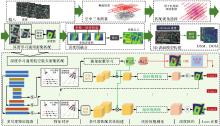
Fig. 1
Processing flow of the general Deep3D framework"

Tab. 1
The hyper-parameters of deep-learning-based dense matching network"
| 超参数类型 | 设置 |
|---|---|
| 深度采样平面数量 | {48,32,8} |
| 深度采样间隔 | WHU-OMVS:{(dmax-dmin)/48 m,0.2 m,0.1 m} DTU:{4 mm,2 mm,1 mm} |
| 匹配视角数量 | 5 |
| 损失函数权重因子{λ0,λ1,λ2,λ3} | {0.5,0.5,1,2} |
| 迭代次数 | ~25万 |
| 训练批次大小 | 1 |
| 优化器与学习率 | RMSProp |
| 学习率 | 0.001 |
Tab. 2
Comparison of reconstruction accuracy of six solutions on the WHU-OMVS test area"
| 软件/方案 | PAG0.2 m/(%)↑ | PAG0.4 m/(%)↑ | PAG0.6 m/(%)↑ | MAE/m T=20 m↓ | RMSE/m T=20 m↓ | Runtime/min↓ |
|---|---|---|---|---|---|---|
| ContextCapture | 83.35 | 95.28 | 97.18 | 0.190 | 0.916 | 128 |
| Metashape | 88.34 | 95.41 | 97.21 | 0.170 | 0.972 | 193 |
| SURE-Aerial | 60.68 | 82.20 | 90.49 | 0.324 | 1.049 | 134 |
| COLMAP | 80.33 | 92.39 | 95.67 | 0.236 | 1.193 | 412 |
| OpenMVS | 83.26 | 94.09 | 96.53 | 0.202 | 0.998 | 299 |
| Deep3D | 86.75 | 95.47 | 97.60 | 0.166 | 0.803 | 187 |
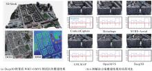
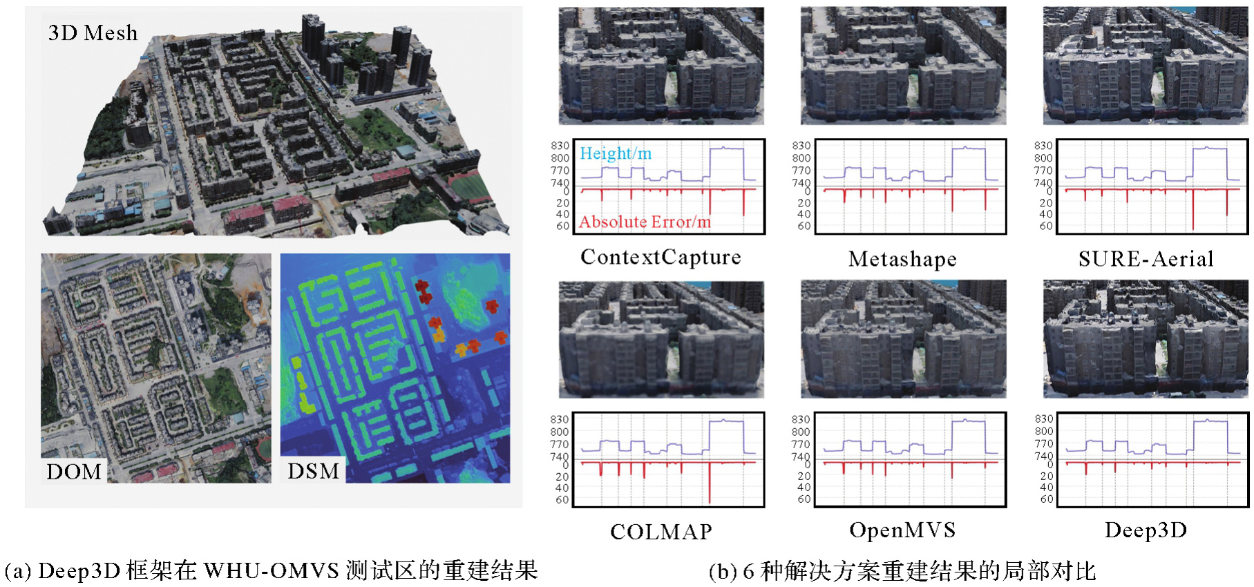
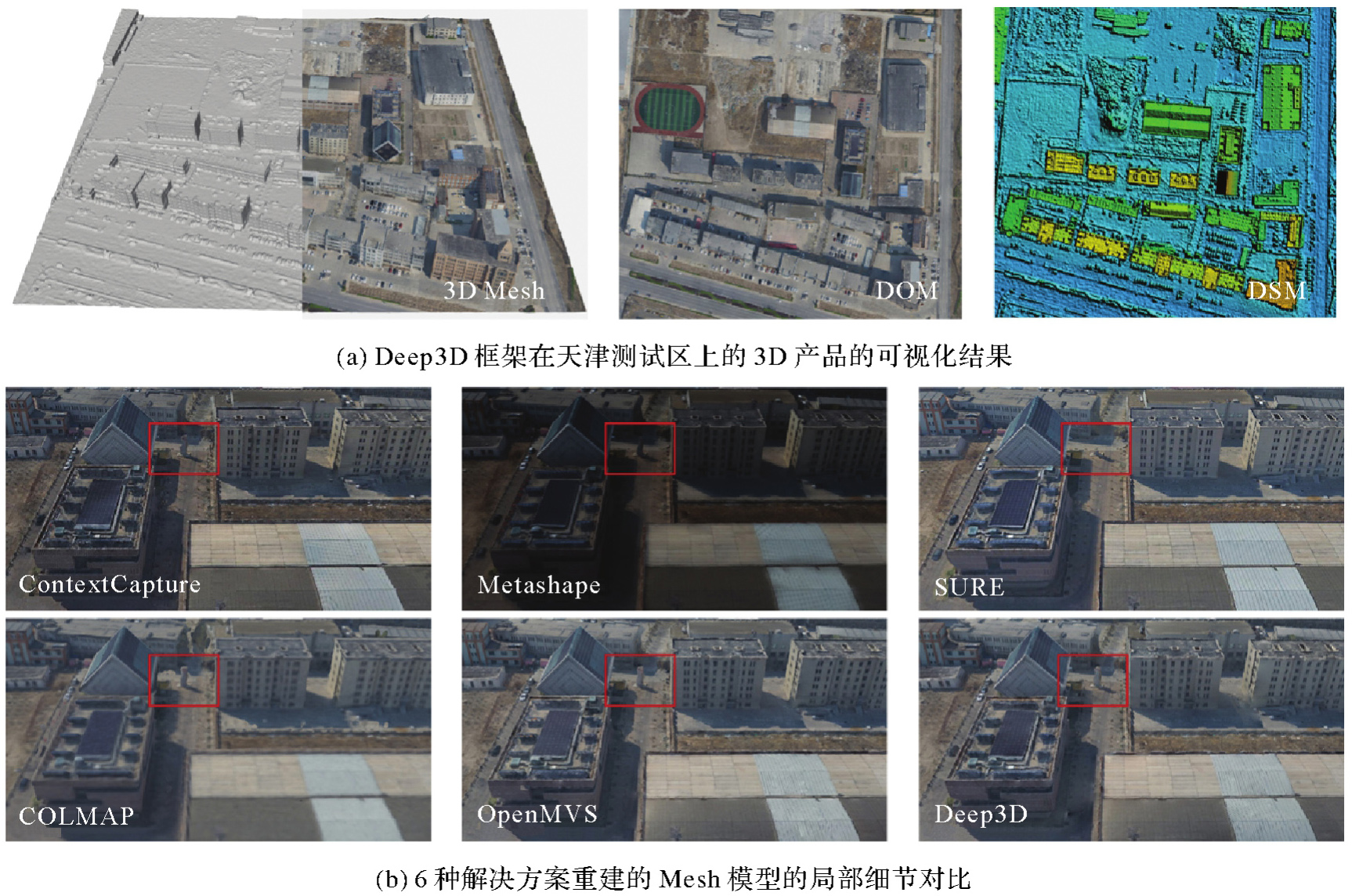
Fig. 2
The reconstruction and comparison results of the Deep3D framework on the WHU-OMVS dataset"
Tab. 3
Comparison of reconstruction accuracy of six solutions on the Tianjin test area"
| 软件/方案 | PAG0.2 m/(%)↑ | PAG0.4 m/(%)↑ | PAG0.6 m/(%)↑ | MAE/m T=20 m↓ | RMSE/m T=20 m↓ | Runtime/min↓ |
|---|---|---|---|---|---|---|
| ContextCapture | 55.49 | 75.28 | 80.69 | 0.822 | 2.189 | 65.2 |
| Metashape | 63.27 | 76.42 | 80.55 | 0.811 | 2.153 | 133.2 |
| SURE-Aerial | 54.87 | 71.98 | 78.65 | 0.841 | 2.177 | 75.0 |
| COLMAP | 65.29 | 76.07 | 80.41 | 0.812 | 2.205 | 300.5 |
| OpenMVS | 63.57 | 75.38 | 80.22 | 0.830 | 2.243 | 204.5 |
| Deep3D | 66.98 | 76.83 | 81.01 | 0.818 | 2.250 | 100.9 |
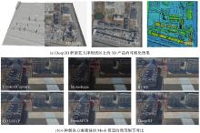
Fig. 3
The reconstruction and comparison results on the Tianjin test set"
Tab. 4
Comparison of different training strategies for Deep3D framework on Tianjin test area"
| 训练策略 | PAG0.2 m/(%)↑ | PAG0.4 m/(%)↑ | PAG0.6 m/(%)↑ | MAE/m T=20 m↓ | RMSE/m T=20 m↓ |
|---|---|---|---|---|---|
| DTU预训练模型 | 65.89 | 76.31 | 80.74 | 0.822 | 2.257 |
| WHU-OMVS预训练模型 | 66.98 | 76.83 | 81.01 | 0.818 | 2.250 |
| 无监督训练模型 | 64.93 | 76.39 | 80.81 | 0.832 | 2.281 |
| 模拟数据训练模型 | 66.51 | 76.84 | 81.05 | 0.819 | 2.248 |
Tab. 5
Comparison of Deep3D and other solutions on satellite images"
| 数据集 | 评价指标 | Metashape(PhotoScan) | Adapted COLMAP | Deep3D |
|---|---|---|---|---|
| WHU-TLC(ZY3-02影像) | RMSE/m | 13.047 | 4.714 | 3.654 |
| MAE/m | 2.693 | 2.168 | 1.895 | |
| PAG2.5 m/(%) | 56.59 | 58.78 | 64.82 | |
| PAG7.5 m/(%) | 75.46 | 76.80 | 80.05 | |
| MVS3D(World View-3影像) | RMSE/m | 3.464 | 8.397 | 3.242 |
| Median/m | 0.495 | 0.371 | 0.397 | |
| PAG1.0 m/(%) | 56.73 | 50.38 | 60.48 |
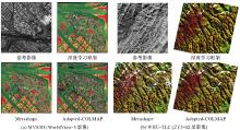
Fig. 4
The visualization of DSM results produced by three solutions on MVS3D dataset and WHU-TLC dataset respectively"

| [1] | SCHÖNBERGER J L, FRAHM J M. Structure-from-motion revisited[C]//Proceedings of 2016 IEEE Conference on Computer Vision and Pattern Recognition (CVPR). Las Vegas: IEEE, 2016: 4104-4113. |
| [2] | SCHÖNBERGER J L, ZHENG Enliang, FRAHM J M, et al. Pixelwise view selection for unstructured multi-view stereo[C]//Proceedings of 2016 Computer Vision-ECCV. Cham: Springer, 2016: 501-518. |
| [3] | MOULON P, MONASSE P, PERROT R, et al. OpenMVG: open multiple view geometry[C]//Proceedings of 2017 Reproducible Research in Pattern Recognition. Cham: Springer, 2017: 60-74. |
| [4] | OpenMVS: open multi-view stereo reconstruction library[CP]. [2023-07-24]. https://github.com/cdcseacave/openMVS. |
| [5] | GRIWODZ C, GASPARINI S, CALVET L, et al. AliceVision Meshroom: an open-source 3D reconstruction pipeline[C]//Proceedings of the 12th ACM Multimedia Systems Conference. Istanbul, Turkey: ACM press, 2021: 241-247. |
| [6] | RUPNIK E, DAAKIR M, PIERROT DESEILLIGNY M. MicMac-a free, open-source solution for photogrammetry[J]. Open Geospatial Data, Software and Standards, 2017, 2(1): 14. |
| [7] | HIRSCHMULLER H. Stereo processing by semiglobal matching and mutual information[J]. IEEE Transactions on Pattern Analysis and Machine Intelligence, 2008, 30(2): 328-341. |
| [8] | BLEYER M, RHEMANN C, ROTHER C. PatchMatch stereo - stereo matching with slanted support windows[C]//Proceedings of 2011 British Machine Vision Conference. Dundee: British Machine Vision Association, 2011: 14. |
| [9] | ROTHERMEL M, WENZEL K, FRITSCH D, et al. SURE: photogrammetric surface reconstruction from imagery[C]//Proceedings of 2012 LC3D Workshop. Berlin: [s.n.], 2012. |
| [10] |
龚健雅, 季顺平. 摄影测量与深度学习[J]. 测绘学报, 2018, 47(6): 693-704. DOI: .
doi: 10.11947/j.AGCS.2018.20170640 |
|
GONG Jianya, JI Shunping. Photogrammetry and deep learning[J]. Acta Geodaetica et Cartographica Sinica, 2018, 47(6): 693-704. DOI: .
doi: 10.11947/j.AGCS.2018.20170640 |
|
| [11] | LIU J, JI S, ZHANG C, et al. Evaluation of deep learning based stereo matching methods: from ground to aerial images[J]. The International Archives of the Photogrammetry, Remote Sensing and Spatial Information Sciences, 2018, XLII-2: 593-597. |
| [12] | YAO Yao, LUO Zixin, LI Shiwei, et al. MVSNet: depth inference for unstructured multi-view stereo[C]//Proceedings of 2018 Computer Vision-ECCV. Cham: Springer, 2018: 785-801. |
| [13] | CHANG Jiaren, CHANG Peichun, CHEN Yongsheng. Attention-aware feature aggregation for real-time stereo matching on edge devices[C]//Proceedings of 2020 Computer Vision. Cham: Springer, 2021: 365-380. |
| [14] | ZHANG Xudong, HU Yutao, WANG Haochen, et al. Long-range attention network for multi-view stereo[C]//Proceedings of 2021 IEEE Winter Conference on Applications of Computer Vision. Waikoloa: IEEE, 2021: 3781-3790. |
| [15] | DING Yikang, YUAN Wentao, ZHU Qingtian, et al. TransMVSNet: global context-aware multi-view stereo network with transformers[C]//Proceedings of 2022 IEEE/CVF Conference on Computer Vision and Pattern Recognition. New Orleans: IEEE, 2022: 8575-8584. |
| [16] | ZHANG Jingyang, LI Shiwei, LUO Zixin, et al. Vis—MVSNet: visibility-aware multi-view stereo network[J]. International Journal of Computer Vision, 2023, 131(1): 199-214. |
| [17] | XU Qingshan, SU Wanjuan, QI Yuhang, et al. Learning inverse depth regression for pixel wise visibility-aware multi-view stereo networks[J]. International Journal of Computer Vision, 2022, 130(8): 2040-2059. |
| [18] | WEI Zizhuang, ZHU Qingtian, MIN Chen, et al. AA-RMVSNet: adaptive aggregation recurrent multi-view stereo network[C]//Proceedings of 2021 IEEE/CVF International Conference on Computer Vision. Montreal: IEEE, 2021: 6167-6176. |
| [19] | YAO Yao, LUO Zixin, LI Shiwei, et al. Recurrent MVSNet for high-resolution multi-view stereo depth inference[C]//Proceedings of 2019 IEEE/CVF Conference on Computer Vision and Pattern Recognition. Long Beach: IEEE, 2019: 5520-5529. |
| [20] | LIU Jin, JI Shunping. A novel recurrent encoder-decoder structure for large-scale multi-view stereo reconstruction from an open aerial dataset[C]//Proceedings of 2020 IEEE/CVF Conference on Computer Vision and Pattern Recognition. Seattle: IEEE, 2020: 6049-6058. |
| [21] | YAN Jianfeng, WEI Zizhuang, YI Hongwei, et al. Dense hybrid recurrent multi-view stereo net with dynamic consistency checking[C]//Proceedings of 2020 Computer Vision. Cham: Springer, 2020: 674-689. |
| [22] | CHEN Poheng, YANG H C, CHEN Kuanwen, et al. MVSNet: learning depth-based attention pyramid features for multi-view stereo[J]. IEEE Transactions on Image Processing, 2020, 29: 7261-7273. |
| [23] | PENG Rui, WANG Rongjie, WANG Zhenyu, et al. Rethinking depth estimation for multi-view stereo: a unified representation[C]//Proceedings of 2022 IEEE/CVF Conference on Computer Vision and Pattern Recognition. New Orleans: IEEE, 2022: 8635-8644. |
| [24] | GU Xiaodong, FAN Zhiwen, ZHU Siyu, et al. Cascade cost volume for high-resolution multi-view stereo and stereo matching[C]//Proceedings of 2020 IEEE/CVF Conference on Computer Vision and Pattern Recognition. Seattle: IEEE, 2020: 2492-2501. |
| [25] | CHENG Shuo, XU Zexiang, ZHU Shilin, et al. Deep stereo using adaptive thin volume representation with uncertainty awareness[C]//Proceedings of 2020 IEEE/CVF Conference on Computer Vision and Pattern Recognition. Seattle: IEEE, 2020: 2521-2531. |
| [26] | YANG Jiayu, MAO Wei, ALVAREZ J M, et al. Cost volume pyramid based depth inference for multi-view stereo[C]//Proceedings of 2020 IEEE/CVF Conference on Computer Vision and Pattern Recognition. Seattle: IEEE, 2020: 4876-4885. |
| [27] | DAI Yuchao, ZHU Zhidong, RAO Zhibo, et al. MVS2: deep unsupervised multi-view stereo with multi-view symmetry[C]//Proceedings of 2019 International Conference on 3D Vision. Quebec City: IEEE, 2019: 1-8. |
| [28] | HUANG Baichuan, YI Hongwei, HUANG Can, et al. M3VSNET: unsupervised multi-metric multi-view stereo network[C]//Proceedings of 2021 IEEE International Conference on Image Processing. Anchorage: IEEE, 2021: 3163-3167. |
| [29] | XU Hongbin, ZHOU Zhipeng, QIAO Yu, et al. Self-supervised multi-view stereo via effective co-segmentation and data-augmentation[C]//Proceedings of 2021 AAAI Conference on Artificial Intelligence. [s.l.]: PKS, 2021: 3030-3038. |
| [30] |
刘瑾, 季顺平. 基于深度学习的航空遥感影像密集匹配[J]. 测绘学报, 2019, 48(9): 1141-1150. DOI: .
doi: 10.11947/j.AGCS.2019.20180247 |
|
LIU Jin, JI Shunping. Deep learning based dense matching for aerial remote sensing images[J]. Acta Geodaetica et Cartographica Sinica, 2019, 48(9): 1141-1150. DOI: .
doi: 10.11947/j.AGCS.2019.20180247 |
|
| [31] | 上海人工智能实验室. 书生·天际[EB/OL]. [2023-07-24]. https://landmark.intern-ai.org.cn/. |
| Shanghai AI Lab. LandMark[EB/OL]. [2023-07-24]. https://landmark.intern-ai.org.cn/. | |
| [32] | CHEN Peimin, HUANG Huabing, LIU Jinying, et al. Leveraging Chinese GaoFen-7 imagery for high-resolution building height estimation in multiple cities[J]. Remote Sensing of Environment, 2023, 298: 113802. |
| [33] | FRASER C S, HANLEY H B. Bias compensation in rational functions for IKONOS satellite imagery[J]. Photogrammetric Engineering & Remote Sensing, 2003, 69(1): 53-57. |
| [34] | HE Kaiming, ZHANG Xiangyu, REN Shaoqing, et al. Spatial pyramid pooling in deep convolutional networks for visual recognition[C]//Proceedings of 2014 Computer Vision. Cham: Springer, 2014: 346-361. |
| [35] | GAO Jian, LIU Jin, JI Shunping. A general deep learning based framework for 3D reconstruction from multi-view stereo satellite images[J]. ISPRS Journal of Photogrammetry and Remote Sensing, 2023, 195: 446-461. |
| [36] | JANCOSEK M, PAJDLA T. Exploiting visibility information in surface reconstruction to preserve weakly supported surfaces[J]. International Scholarly Research Notices, 2014, 2014: 798595. |
| [37] | VU H H, LABATUT P, PONS J P, et al. High accuracy and visibility-consistent dense multiview stereo[J]. IEEE Transactions on Pattern Analysis and Machine Intelligence, 2012, 34(5): 889-901. |
| [38] | WAECHTER M, MOEHRLE N, GOESELE M. Let there be color! large-scale texturing of 3D reconstructions[C]//Proceedings of 2014 Computer Vision. Cham: Springer, 2014: 836-850. |
| [39] | PÉREZ P, GANGNET M, BLAKE A. Poisson image editing[J]. ACM Transactions on Graphics, 2003, 22(3): 313-318. |
| [40] | AANÆS H, JENSEN R R, VOGIATZIS G, et al. Large-scale data for multiple-view stereopsis[J]. International Journal of Computer Vision, 2016, 120(2): 153-168. |
| [41] | GAO Jian, LIU Jin, JI Shunping. Rational polynomial camera model warping for deep learning based satellite multi-view stereo matching[C]//Proceedings of 2021 IEEE/CVF International Conference on Computer Vision. Montreal: IEEE, 2021: 6128-6137. |
| [42] | BOSCH M, KURTZ Z, HAGSTROM S, et al. A multiple view stereo benchmark for satellite imagery[C]//Proceedings of 2016 IEEE Applied Imagery Pattern Recognition Workshop. Washington DC: IEEE, 2016: 1-9. |
| [43] | AGISOFT. Agisoft metashape[EB/OL]. [2023-07-24]. https://www.agisoft.com/. |
| [44] | ZHANG Kai, SNAVELY N, SUN Jin. Leveraging vision reconstruction pipelines for satellite imagery[C]//Proceedings of 2019 IEEE/CVF International Conference on Computer Vision Workshop. Seoul: IEEE, 2019: 2139-2148. |
| [45] | FAN Bin, KONG Qingqun, WANG Xinchao, et al. A performance evaluation of local features for image-based 3D reconstruction[J]. IEEE Transactions on Image Processing, 2019, 28(10): 4774-4789. |
| [46] | MA Jiayi, JIANG Xingyu, FAN Aoxiang, et al. Image matching from handcrafted to deep features: a survey[J]. International Journal of Computer Vision, 2021, 129(1): 23-79. |
| [47] | ZHANG Jingyang, YAO Yao, QUAN Long. Learning signed distance field for multi-view surface reconstruction[C]//Proceedings of 2021 IEEE/CVF International Conference on Computer Vision. Montreal: IEEE, 2021: 6505-6514. |
| [1] | Jiayao WANG, Lin CHEN, Shiyuan CHENG, Lijun WANG, Siqi XIONG. Artificial intelligence empowering the digital-intelligent transformation of cartographic science [J]. Acta Geodaetica et Cartographica Sinica, 2026, 55(3): 381-389. |
| [2] | Xiaomin LU, Zhiyi ZHANG, Haowen YAN, Yi HE, Xiaoning SU. A recognition method for building group pattern integrating deep graph infomax and multilayer perceptron [J]. Acta Geodaetica et Cartographica Sinica, 2026, 55(3): 425-438. |
| [3] | Jixian ZHANG, Haiyan GU, Huan NI, Haitao LI, Yi YANG, Shaopeng DING, Songman SUI. Deep learning methods for remote sensing intelligent change detection: evolution and development [J]. Acta Geodaetica et Cartographica Sinica, 2025, 54(8): 1347-1370. |
| [4] | Shuai FANG, Jiaen LIU, Jing ZHANG. Spatio-temporal fusion algorithm based on adaptive reference feature incorporation and multi-scale feature aggregation [J]. Acta Geodaetica et Cartographica Sinica, 2025, 54(8): 1476-1488. |
| [5] | Yakun XIE, Yaoji ZHAO, Jiaxing TU, Ruifeng XIA, Dejun FENG, Suning LIU, Hongyu CHEN, Jun ZHU. Edge and global features integrated network for salient object detection in optical remote sensing images [J]. Acta Geodaetica et Cartographica Sinica, 2025, 54(7): 1265-1279. |
| [6] | Nina MENG, Fengmei LI, Xiaodong ZHOU. Data and cognition dual-driven building group generalization results and scale consistency assessment [J]. Acta Geodaetica et Cartographica Sinica, 2025, 54(7): 1318-1331. |
| [7] | Yaqing WANG, Zhonghui WANG. River network automated selection method based on heterogeneous graph convolutional networks [J]. Acta Geodaetica et Cartographica Sinica, 2025, 54(7): 1332-1345. |
| [8] | Zibo DONG, Jingxue WANG, Lijing BU, Lin FANG, Zhenghui XU. MAFNet: building extraction method from remote sensing images based on multi-scale atrous fusion network [J]. Acta Geodaetica et Cartographica Sinica, 2025, 54(6): 1094-1106. |
| [9] | Xiaoya AN, Weiru GUO, Pengxin ZHANG, Xinxin LI, Lei SHI. Ship trajectories clustering method considering similarity in geometric position and mobility features [J]. Acta Geodaetica et Cartographica Sinica, 2025, 54(6): 1107-1121. |
| [10] | Chao WANG, Tianyu CHEN, Tong ZHANG, Tanvir AHMED, Liqiang JI, Tao XIE, Jiajun YANG, Shuai WANG. Multi-sensor optical remote sensing images change detection based on global differential enhancement module and balance penalty loss [J]. Acta Geodaetica et Cartographica Sinica, 2025, 54(5): 873-887. |
| [11] | Qingli LUO, Xueyan LI, Guoman HUANG, Honghui CHEN, Minglong XUE, Jian LI. AOSN: alpha optimal structure network for height estimation from a single SAR image in mountain areas [J]. Acta Geodaetica et Cartographica Sinica, 2025, 54(5): 888-898. |
| [12] | Wei TU, Xiangyuan CHI, Tianhong ZHAO, Jian YANG, Shiping ZHU, Deli CHEN. Multi-view spatio-temporal graph convolutional networks model for urban drainage networks flow prediction [J]. Acta Geodaetica et Cartographica Sinica, 2025, 54(2): 334-344. |
| [13] | Zhaoyang HOU, Haowen YAN, Liming ZHANG, Rongjuan MA, Ruitao QU. Zero-watermark copyright protection method for remote sensing images based on coupled neural P system and blockchain [J]. Acta Geodaetica et Cartographica Sinica, 2025, 54(12): 2247-2261. |
| [14] | Zhili ZHANG, Huiwei JIANG, Xiangyun HU. A minimal-interaction framework for accurate and batch extraction of geospatial objects from remote sensing imagery [J]. Acta Geodaetica et Cartographica Sinica, 2025, 54(10): 1863-1876. |
| [15] | Zhenghua ZHANG, Guoliang CHEN. A lightweight rotation-invariant network for LiDAR-based place recognition [J]. Acta Geodaetica et Cartographica Sinica, 2025, 54(1): 90-103. |
| Viewed | ||||||
|
Full text |
|
|||||
|
Abstract |
|
|||||